16.5 miles, via Daisy Hill, Broad Oaks, Churwell, Beeston Royds, Farnley Junction, Far Royds,
Lower Wortley,Western Flatts Park, Cabbage Hill, Upper Wortley, Armley, Armley Mills,
Leeds & Liverpool Canal, Monk Bridge, Granary Wharf, Leeds Bridge, Brewery Wharf,
Crown Point, Leeds Dock, Huinslet Mills, Knowsthorpe, Thwaite Gate, Thwaite Mills,
Stourton, Belle Isle, Middleton, Sissons Wood, West Wood, Owlers, and Gillroyd.
Our pattern of smooth sailing through the 2022 walking year gets rudely disrupted as the first weekend of Summer lands, as a sequence of national train strike hit the country (after the RMT takes issue with management (and government) seeming to have forgotten that the railways have been important Key Workers over the last two years and ought to be treated accordingly in the wake of the Covid-19 pandemic), and when this is coupled to an ongoing (and total) strike action by Arriva Yorkshire's bus crews in Wakefield district, the outcome for me is that my chosen walking field to the south and east of home has been rendered largely inaccessible by public transport, and enforced local walking will have to fill my weekend, which is not the easiest of tasks as lockdown walks absorbed nearly every path around Morley during 2020/1. We'll have to be creative to ensure we're not repeating ourselves too much as we roll down to Morley station for a 9.20am jump off, initially heading city-bound on a plauisble circular route via the path that rises away above the rock cliff to the top of New Bank Street and thence on to Daisy Hill, joining the rough path into the hidden, and somewhat overgrown valley beyond, which deposits us into the fields of wheat ahead of joining the track that leads up to Broad Oaks farm, where future residential development looks like a certainty, as work has already started on the groundwork in the fields around Lane Side farm, which have kept Morley and Churwell distinct. It can remain rural as we rock past the farmstead, cresting to the view towards the city in the northeast, not being able to approach the railway via the downhill path due to the construction work at the new White Rose station site on the embankment, which can be observed at a distance as we keep on the previously untraced path that leads us into the eastern side of Churwell, landing us by the old chapel and Sunday school on Back Green, which leads to the crossing of the A643 by the Old Golden Fleece Tesco and the memorial garden, before we head down old lane into the terraced and suburban village, passing Bar 27 and the village club on the way down. Hang a left by the old Manor farm and pace a way along New Village Way among the Lego houses of the still expanding village suburb, which continues to grow, having now completely absorbed the site of Snittles farm at the side of the M621, which is passed under to emerge by the side of the embankment of the Leeds New Line, which is passed over as we pace the boundary of the Jewish cemeteries and land on the A62 to pace the Gelderd Road over its crest by the factories on the edge of the Beeston Royds hillside, passing below the abandoned Hilltop cemeteries and joining the railway-side path by the split of the flying Farnley Junction.
 |
| No trainspotting to be had at Morley today. |
 |
| Suburbanism will soon claim the fields of Lane Side farm. |
 |
| White Rose station being constructed, east of Cottingley. |
 |
| The old chapel and Sunday school, Back Green, Churwell. |
 |
| New Village Way, Churwell. |
 |
| Beeston Royds hilltop, from Snittles farm lane. |
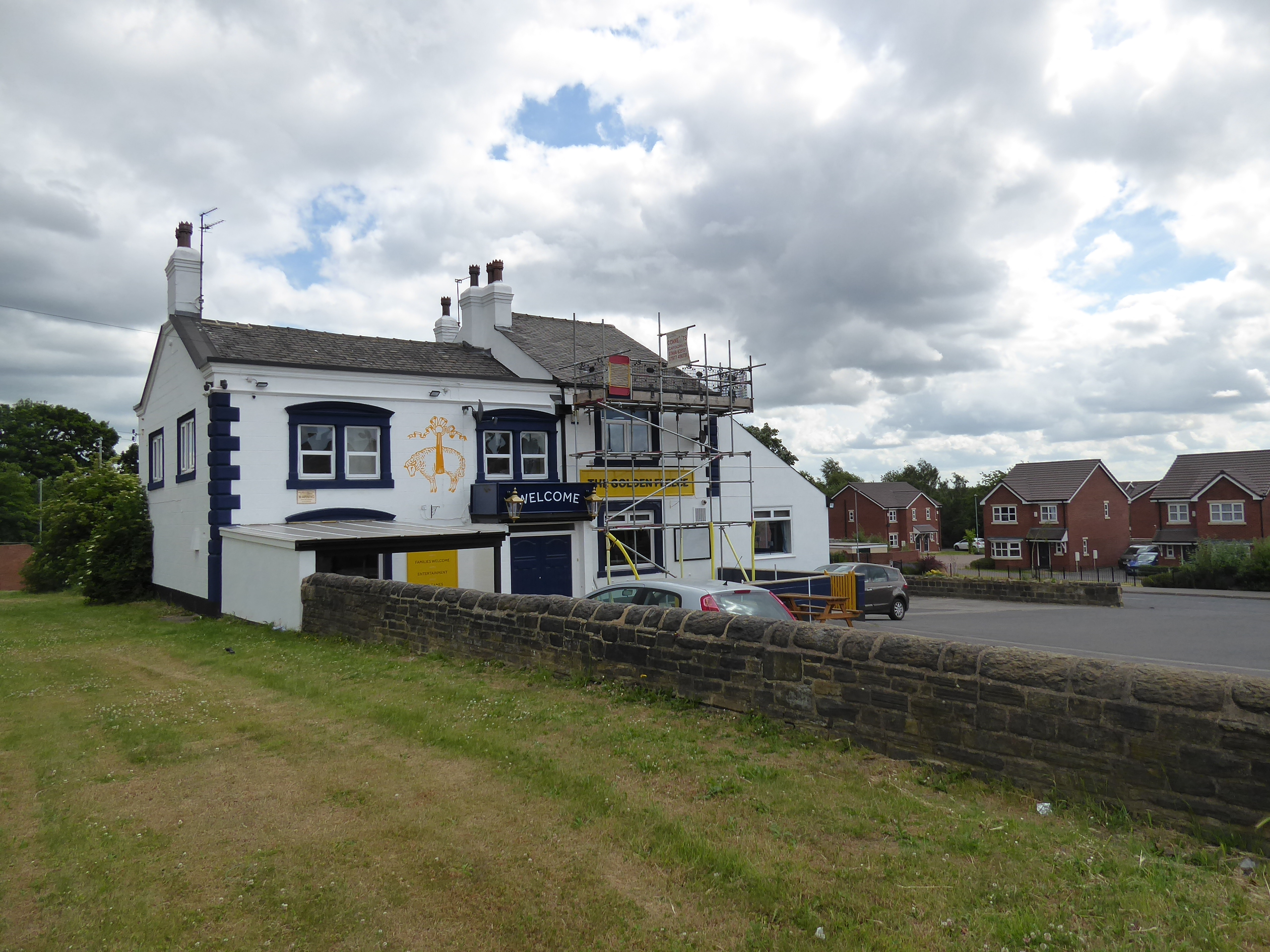
This rough and shaded track leads us over to the now settled-in suburban enclave in the railway triangle and shed site at the other Farnley Junction, passing over the bridge and following Honeybourne Road down by the side of Booker Wholesale to cross the A6110 Ring Road relatively easily, before we pass though the commercial industrial portion of Far Royds via Royds Lane, passing over Wortley Beck and rising to pass across the A58 Whitehall Road and thence uphill into the urban spread of Lower Wortley, via Walker's Lane and the turn onto the footpath that leads to Kellett Lane and across to the passage over to Lower Wortley Road, and the way up between the terraces along Western Road. This leads us to the western end of Western Flatts Park, which offers quite the steepest ascent among its fields and trees, rising us over its so-called cliff to a fine reverse view before exiting across Green Hill Lane to follow the declining path behind the back gardens of the suburban closes to meet the wild edge of the Cabbage Hill green space and be lead on down Barras Garth Road to meet Upper Wortley Road as it slips between the Liberal Club and the Golden Fleece inn, where a turn is made up Thornhill Road to take us up to Tong Road, passing over the Leeds-Bradford railway at the west end of its skewed tunnel and pacing the pavement down to the corner of Wesley Road. The intactness of the former Lyric cinema has top be noted here before we rise up to pass by St Bartholomew's church, the most imposing parish church in the city, before we tangle up with Armley's terraces and come down to the end of Town Street, where we cross over by the Branch Library (and Community Hub) and the Malt Shovel inn, and follow Crab Lane down to the passage among the roadworks on the A647 Armley Road, where the severed end of Canal Road is met, to be followed down to the passage over the Leeds-Skipton line, by the lost Canal Road station and onto the Aire-valley side by the enduring industrial band.
 |
| The bridge leading to the Farnley Junction enclave. |
 |
| The ascent of Walker's Lane, Lower Wortley. |
 |
| The view from Western Flatts park. |
 |
| The Golden Fleece, Upper Wortley. |
 |
| St Bartholomew's church, Armley. |
 |
| The most prominent carpet store in the city, Armley Road. |
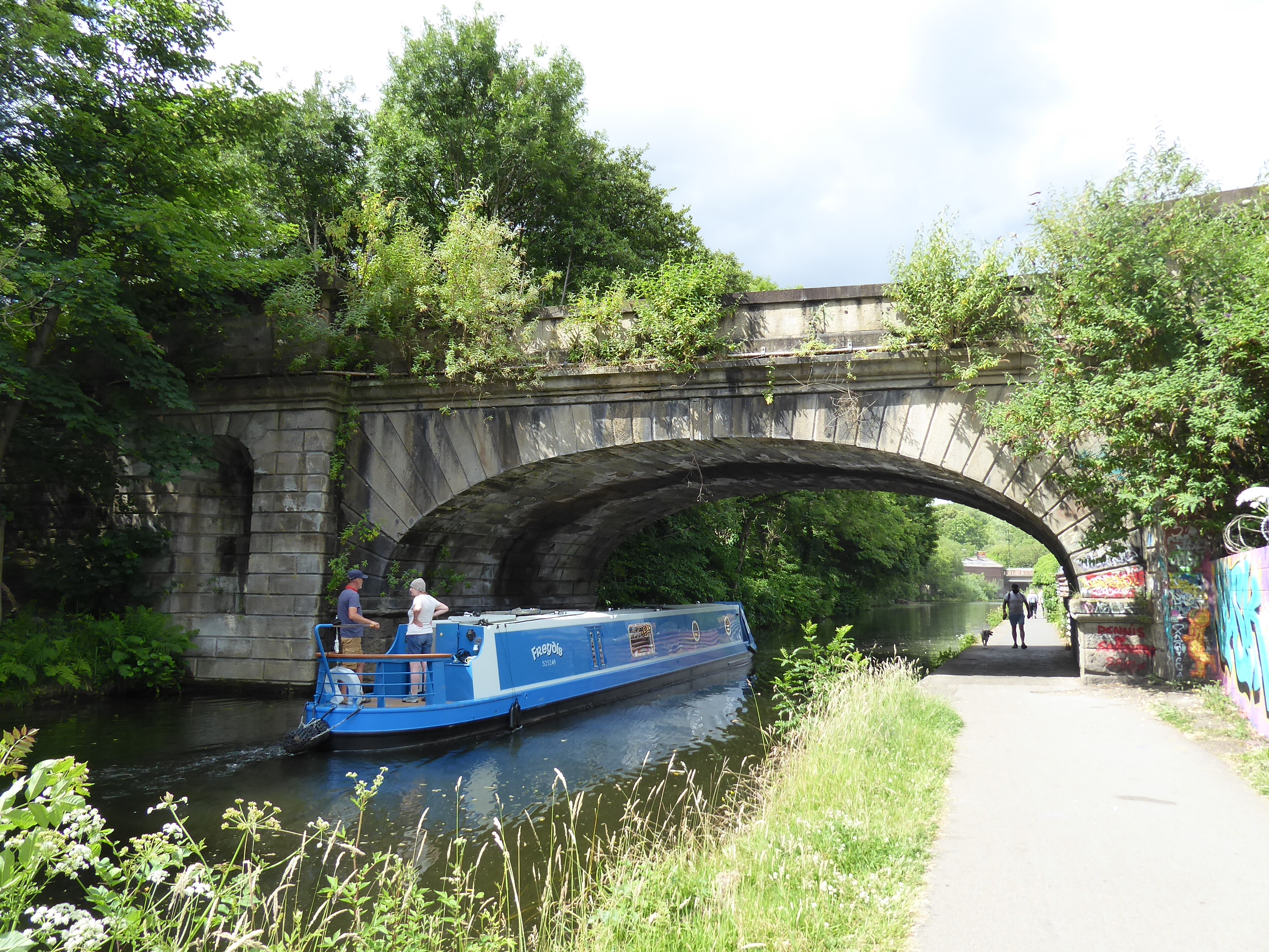
Ahead of the canal, we can detour slightly to take a closer look at the Leeds Industrial Museum at Armley Mills, wandering down its driveway to discover that even when landing after 11am, we've arrived before it's gates have been opened for access and business, and thus thoughts of having a poke around inside are cast aside and instead we pace around to the steps that descend to the towpath of the Leeds & Liverpool canal to confirm that there are no really decent angles to spy it from this side, and also no benches to be found in the locality either, as we set off towards the city, below the Viaduct Road and Kirkstall viaduct bridges. The trek along the canal and river paths will form the main feature of this trip, joining a route that's popular with many other walkers and cyclists, as we pace along the brow of the high wooded embankments on the south side of the river Aire, which is glimpsed across occasionally to reveal the changing post-industrial dynamic along the Kirkstall and Burley Roads, while suburbanism has claimed the finger of land between Spring Garden and Oddy's locks, while Castleton Mill has had a makeover and burst of re-use since we last came this way a decade ago(!), while free entertainment comes below the Wellington Road bridges as an over-height boat tries to navigate a way under them. Beyond City Island and St Anne's Ings locks we find ourselves among the Monk Bridge developments again, with the five towers on the north side having all topped out since we visited 15 months ago, while the two towers on the south side have now grown their cores to the full height, to eventually overshadow the old Leeds Central viaduct, once access to its elevated walkway is opened up, where we'll break for drinks on the first available bench before pacing in towards the city, hearing more train activity around the western station throat than might have been expected before we land by the Tower Works redevelopment, which almost completely conceals the chimneys that rendered the site historically interesting, landing it squarely on the 'what were they thinking?' list.
 |
| Leeds Industrial Museum, Armley Mills. |
 |
| The Leeds & Liverpool Canal, and Kirkstall Viaduct. |
 |
| The river Aire and its redeveloping north bank. |
 |
| Castleton Mill. |
 |
| New access steps to Leeds Central Viaduct. |
 |
| Seven High-Rises developing around Monk Bridge. |
 |
| More trains than expected on the Leeds station approaches. |
 |
| The Tower Works development, where bad choices were made. |
It's the Leeds Waterfront Festival this weekend, and the crowds of revellers and kayakers have to be avoided as we make our way around the canal basin at Granary Wharf, and pass over the Aire, via the footbridge to Little Neville Street, and as there's no access on either side of the river beyond Victoria Bridge, we'll have to make our way to Leeds Bridge via the financial district along Sovereign Street, and get back on track as we pass down Dock Street and Navigation Walk to see how well they've cleaned up after the flooding of 2015, before passing along the riverside at Brewery Wharf, where the hint of silt still sits along the walkways. Pass under Crown Point bridge and across the throat of Leeds Dock, where the festive activities are in full swing in the plaza below the Royal Armouries, where we'll hurry by to join the head of the Trans Pennine Trail link at Leeds Lock, the start of the Aire & Calder navigation, where the surface has been significantly improved as it traces a way out of the city, passing the apartment blocks on the East Street side and the moorings ahead of the Clarence Dock student flats, with the riverfront development continuing along both banks, down to the Citu Climate Innovation District, where a new footbridge has been installed to link them, and a coffee bar offers another bench to water upon. The path continues down to the South Accommodation Road bridge, beyond which Hunslet Mills are finally found to be in the grip of redevelopment after standing derelict for so long, while the north bank greens over, concealing the industrial usages of Knowsthorpe and Cross Green beyond, before we meet the low-rise housing that's making the best of the riverside location, despite being crammed in behind the still-industrial portions of Hunslet, and then come up to the heavily reworked river channel as Knostrop, where the Aire was redirected from the south to the north side of the Navigation channel, before the cut itself was layer dug out to widen the river as a flood management measure.
 |
| Crossing the Aire at Granary Wharf. |
 |
| Crossing the Aire at Leeds Bridge. |
 |
| The Brewery Wharf riverfront. |
 |
| Leeds Dock. |
 |
| The Citu footbridge. |
 |
| Hunslet Mills getting the revival treatment. |
 |
| The stub of the old River Aire channel, Knostrop. |
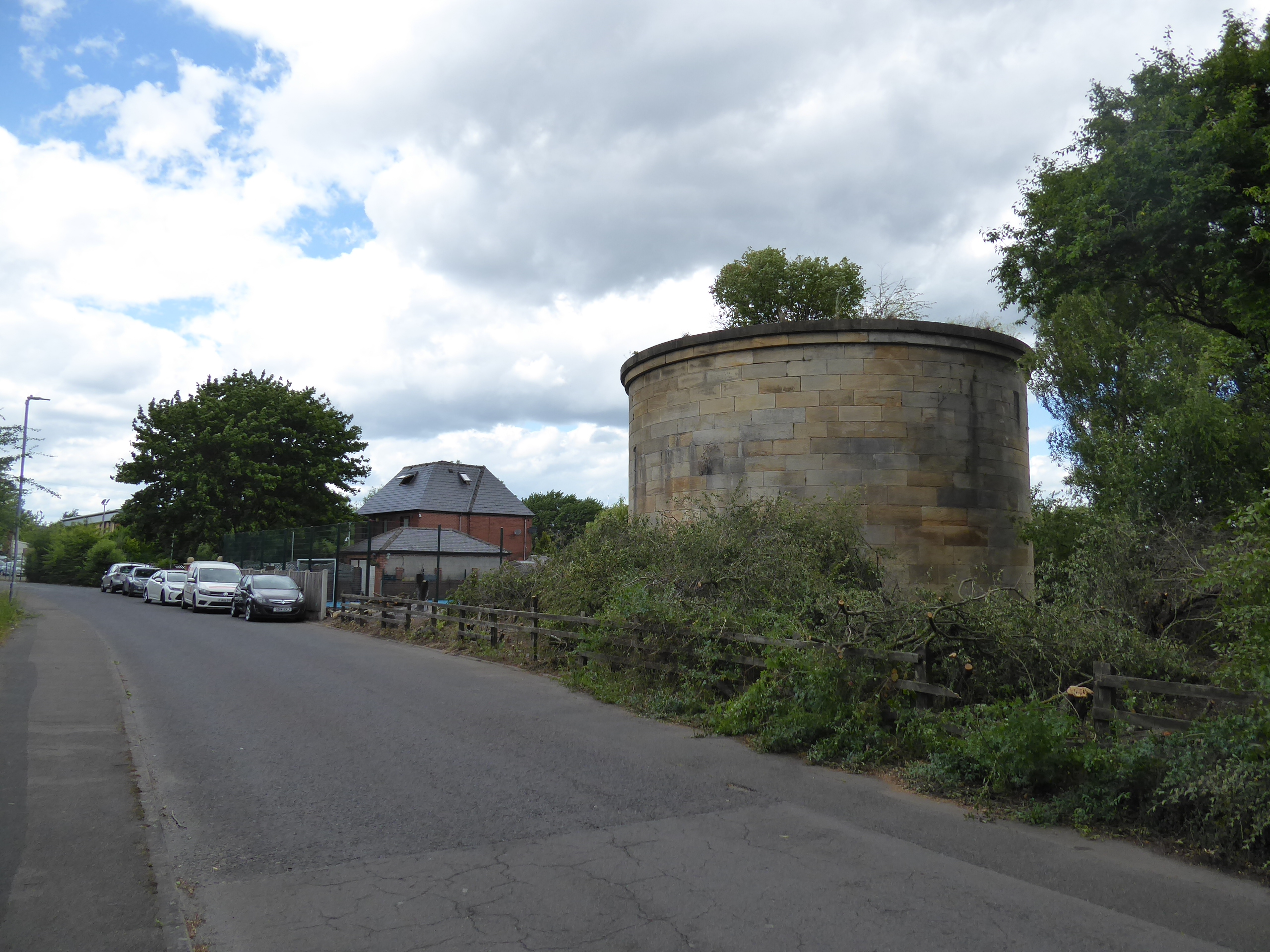
We cross to the Aire’s north bank again, over the surprisingly lightweight footbridges at Knostrop Flood, pacing on downstream along the cycleway that feels a bit more settled-in than it did when we came up here in 2018, with a nicely wild riverside green space developing around it below the industrial sites to the north, also noting that we are still limited to access via the TPT route's crossings as we come down to the passage back over the river at the weir and railway viaduct remnants at Thwaite Gate, where the canal detaches itself and we return to the island between them which runs past to faux stone circle and on towards Thwaite Mills. A better planned day would have factored in some time for a visit to the preserved watermill, where I’ve never been previously, but we’ll have to limit ourselves to admiring the site from without before we quit our riverside themed trek and head for the inbound leg, passing back to the south bank via the road access bridge and pacing Thwaite Lane past the Sea Cadets’ compound and the pivot tower of Knostrop swing bridge before we emerge out onto the A639 by the Skoda dealership, at the end of Pontefract Road, crossing by the Stourton & Thwaite Gate war memorial and rise with the Wakefield Road as it passes the First Direct HQ offices and bridge remnant of the Hunslet Goods line. Beyond the Shell garage and the Queen’s Hotel, we pass across the railway between the Freightliner depot and terminal, before entering the close of houses at Westfield Place North, severed from its community thanks to the construction of the motorway, digging itself through Hunslet, and we pass over the M621 via the available footbridge to the enduring terraced enclave on the southern side, where we’ll drop down to the end of Parnaby Road to follow the path into, and around, the Stourton Park & Ride terminal, which is so new that it doesn’t feature on any online maps, though it already seems to be doing plentiful business, judging by the capacity of its carparks.
 |
| The TPT path, north bank of the Aire. |
 |
| The weir and viaduct remnants, Thwaite Gate. |
 |
| Thwaite Mills. |
 |
| The Knostrop Swing Bridge pivot tower. |
 |
| The Hunslet Goods bridge remanant, Wakefield Road. |
 |
| Westfield Place North, severed by the M621. |
 |
| Stourton Park & Ride terminal. |
A bench provides a last watering spot for the trip before we rise up the access paths to meet Ring Road Middleton as it wends its way uphill through the common fields where horses graze at the northeast corner of the Belle Isle estate, keeping to its pavements rather than seeking the nearby woodland path as the gathering gloom brings unwelcome drizzle as we enter the suburban landscape that has grown around the council estates, mostly after the boundary of the city of Leeds was moved, where a snowbound walk once brought us a few seasons back, while today presenting a look that’s very 1980s, all the way up to the Broom Place lane crossing. Beyond here, we meet the older estate, where the wide plot of the Ring Road was placed in expectation of urban developments than never happened, now standing partly built over before opening up between the redbrick semis to provide a green passage at the middle of the boulevard that leads to the traffic island at the top of Belle Isle Road, where the road gets a whole lot more purposeful and busy, taking us along the local hill crest as we come around to the traffic island by the Asda store, where many trips to the nearby Middleton tip have been driven over the years, and us turning down St George’s Road as it takes us past the other shopping complex and the eponymous community centre and clinic. We slip into a suburban landscape that’s much more contemporary as we follow a pavement among the closes and apartment blocks that doesn’t even feature on my weather-beaten E289, which does lead us to the end of Throstle Road, which leads us back into the older estate landscape past the point where it abruptly terminated its initial growth, sending us along another wide boulevard that suggests the city planners of the past were trying to keep this development spacious and interesting, possibly more so than the current ones as the Throstle Road Rec, previously one of the few green spaces left up here, is currently getting built over, putting more houses on the ground along the way down to the Middleton Park Avenue corner.
 |
| Ring Road Middleton, outside Belle Isle. |
 |
| 80s suburban Belle Isle / Middleton. |
 |
| The wide unsed boulevard of Ring Road Middleton. |
 |
| The active Ring Road, Middleton. |
 |
| Virtually contemporary Middleton, St George's Road. |
 |
| Throstle Road and the vanishing Rec, Middleton. |
Landing on the A654 Thorpe Lane puts us back on more familiar tracks, and it’s going to be a straightforward run home from here, splitting onto the rough path that shadows its way around the southwestern corner of the Middleton estate, where we can watch Ardsley and Tingley pass around on the southern horizon, before we get the old railway line cutting across the landscape and passing over Tingley viaduct, and we’ll descend steeply to meet this via the lower path, shadowing the alignment through Sissons wood, but not trying to enter the cutting itself as it’s looking very damp underfoot down there. We’ll stay on dry tracks until we can get to a point where it is accessible, by the broken cattle creep, where we can rise onto the embankment and get a couple of hundred metres of railway walking in through a surprising amount of overgrowth, before we descend to West Wood Lane as passes out of the woods and under the railway lines, dropping down to Millshaw Beck and noting the amount of culverting and landscaping that has gone on downstream before we rise up to the side of the A653 and cross the Dewsbury Road by the busy McDonald’s site, and then follow Wide Lane as it runs us in towards Morley across the fields of Owlers, where the suburban spread doesn’t seem to have worsened. Past the Gardeners Arms, we join Albert Road by the Newlands Primary academy, but still manage to find a local road that we haven’t traced before as Denshaw Grove leads us through the Gilroyd estate, where not even our lockdown paths brought us among the varieties of local council houses, before we land on Clough Street and run down among the terraces to the Miners Arms & Fisheries corner, and then descend the steps flight down to Valley Road to land us back at the railway station at 4pm, a slow rate for the day as we had no deadline impetus at all, while also having us land well beyond the target of 70 patriotic miles for the month too at 79.3, a challenge target that was never really in doubt, to be honest.
 |
| Railway in the landscape below Middleton / Tingley. |
 |
| Above the railway in Sissons Wood. |
 |
| Railway walking into West Wood. |
 |
| Millshaw Beck valley, with embankment and culvert. |
 |
| Wide Lane, and familiar urban Morley. |
 |
Denshaw Grove and unfamiliar urban Morley.
~~~ |
 |
It's not at all related to my walking tales, but of all my
twitching photography attempts, these Blackbirds snared
on the Valley Road steps might be my favourite so far. |
5,000 Miles Cumulative Total: 5629.4 miles
2022 Total: 344.7 miles
Up Country Total: 5,152.7 miles
Solo Total: 5297.8 miles
5,000 in my 40s Total: 4223.2 miles
Next Up: Normal Service on the South Yorkshire railway station quest is resumed?


No comments:
Post a Comment