Mag Wood, and Armitage Bridge.
 |
Long Distance Trail
means Selfies!
#2 at Holme. |
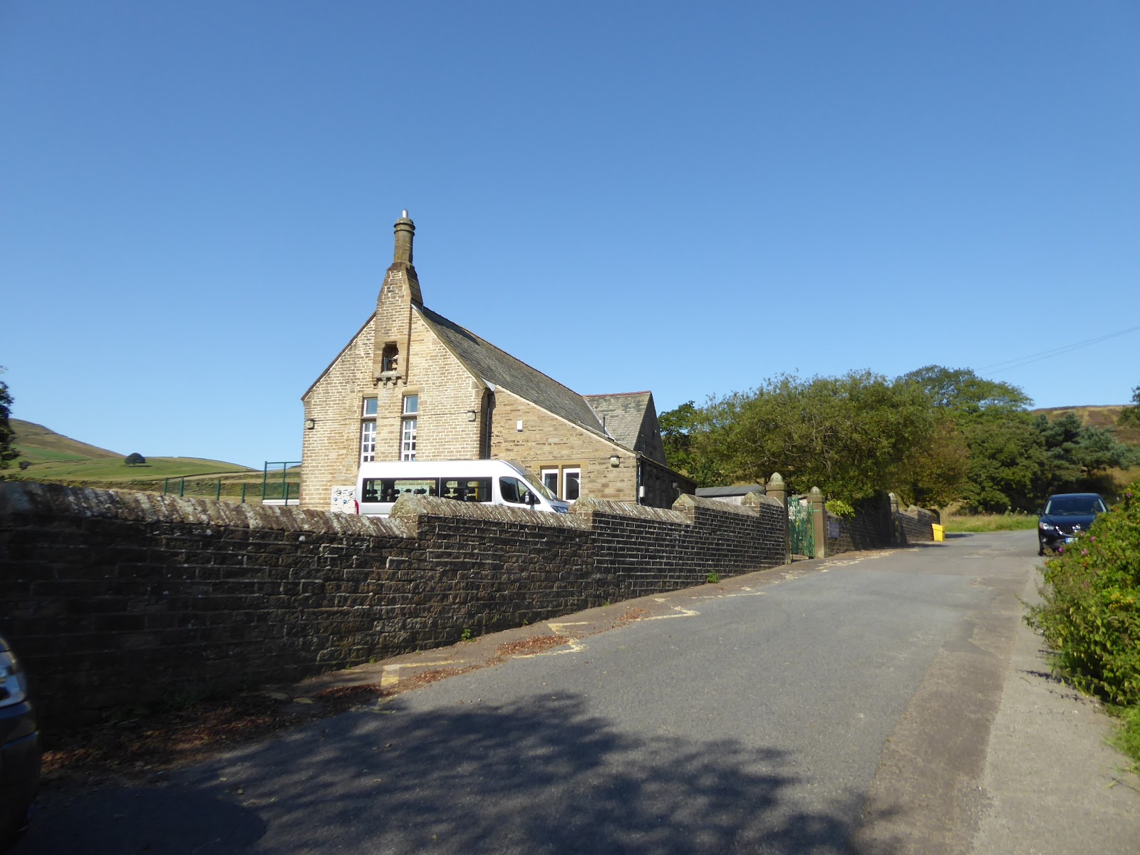
Back to the trail on Bank Holiday Monday morning, and there's absolutely no way to get back out to Holme for a start that could be considered early, as thanks to Sunday bus timetables and the most awkward of travel connections, it's going to be a two hour trip out by train and bus (the uphill ride on the #314 taking as long as the downhill trip did, incidentally) and we can't get going until we've alighted at 10.20am, with the wall of heat hitting you hard, and making you grateful that this isn't going to be anything like a long day on the return leg. It's not often that a day's walk starts with the feeling of peak temperature in the air already, but that's where we are as we set off away from Holme's idyll at the habitable limit of the upper Holme Valley, heading up Meal Hill Road but choosing to not duplicate more footfalls on the Kirklees Way route and instead stick to the lane as it passes out of the village past the school which still endures with possibly the tiniest catchment area, and out into the moorland fields beyond Meal Hill farm, where we crest around the hillside with a fine view downstream. We'll split off Issues Lane, and its alternate route onto Black Hill and instead carry on down Further End Lane, where no right of way endures since the creation of Digley reservoir severed it and the Lumbank farms passed out of the landscape, but I'll strike a blow for reviving old paths as it heads towards the water's perimeter path, with the track petering out as we meet Intake Gutter and strike across the rough path to meet the Kirklees Way path again, which steeply descends as it enters the wood at the reservoir's heel, well illustrating the challenge that comes with any circumnavigation of an artificial lake. Bottom out at the dam of the much older Bilberry reservoir, where the colours of the cloughs beyond are much brighter than when seen in 2014, splitting from the rising route of the Kirklees way path again as we continue onto the north shore of Digley Reservoir, which still show traces of the landscape that it consumed during its construction in the 1950s, as we are mostly kept away from the shore behind the welcome shade of trees before coming round to the remnants of Gilbriding Lane, which gets increasingly overgrown as we rise among the quarries that it once served to the lofty vantage point above the reservoir and its dam.
 |
| Holme Village School, Meal Hill Road. |
 |
| Downstream on the Holme from Further End Lane. |
 |
| Bilberry Reservoir. |
 |
| Digley reservoir from Gilbriding Lane. |
Descend with Digley Royd Lane, enjoying the fine view over the waters to the Holme Moss - Black Hill fringe beyond, to land on the shore by the vast overflow syphon, and find that the way away from this quarter has been redirected, away from the driveway to the waterworks houses and instead sending us down Bank Top Lane for a distance below the dam, and then sharply up though the rough fields to the yard at the houses' eastern end, a path move that seems much more petty than anything else. Thus we start into the field walk beyond, elevating ourselves to gain height opposite the route we took around Crow Hill on the southern side of the valley, and getting Holme Moss to rise as our feature reverse horizon as we clamber over multiple stiles among the sheep on the way over the hamlet of Austonley, which only has one notable house, where the guard dog does its job very volubly and its owner seems to be the only other person to know the Circular route when he queries my walking plan for the day. As we hit the fields beyond again, the sustained heat of the day means we'll be making no effort at all to get this trip in with our aim for a 1.40pm finish, slipping the pace down as the downstream view of the Holme Valley expands, and we count the fields and watch out for the stiles as we shift down into the upper reaches of Stubbin Clough and then ascend up to the isolated former Sunday school on Cold Well Lane, which has the fine addition of a staring terrace attached to its western end. Field walking carries on beyond, with the view back to Holme Moss revealing that it looks its same massively imposing self regardless of the angle its seen from, as we head over to the farm cluster hamlet of Hogley, where a couple of vintage tractors are parked amongst the recently mown hay, notable because they are both manufactured by David Brown of Meltham, and once on tarmac we meet the first habitation of any size since we set out, looking contemporaneously expensive and filling out the cresting hill above the deep clough of Black Sike.
 |
| The Reservoir Houses that Shall Not Be Approached. |
 |
| Austonley House. |
 |
| The Cold Hill Sunday School. |
 |
| Hogley farm hamlet. |
To carry on east, we have to descend though it, which is a steepling drop into the amazingly cool and refreshing atmosphere of Brook Wood to cross the stream at its base and then plough sharply uphill on its far bank back into the unrelenting sunshine to make our passage up to the A635 Greenfield Road, the so far unwalked Trans-Pennine route out of this valley, which we pass over to continue on the ascending lane that head past Newland farm and onwards to the perimeter of Upperthong, at the outermost reach of greater Holmfirth. This was once an independent settlement above the valley, but the town below has gradually grown out to meet it on a strange suburban tangent, but the feeling of the old village is entirely intact along Upperthong Town Gate, with a smart villa at its west end, the Royal Oak inn at its heart and an accumulation of farmsteads and weavers cottages along its length, only gaining a 20th century suburban face as we hit its east end at Lydgate, where the eastward view from Castle Hill around to Cheese Nab almost completely justifies its presence. Back into the fields we head as the opening stretches of the Circular walk form our new horizon, heading north-ish as the path leads over to the fogotten track of Back lane and then sharply downhill to make a shaded crossing of Wickins Dike, one of the many hidden streams of the Holme Valley, close to the amazingly named house of Wolfstones Gardens, beyond which we rise to pass around the edge of the seemingly expanding Crimbles plantation, which brings us to the Brown Hill farmstead, beyond which we strike towards Netherthong. It's a long field walk with an expansive southern view, that takes us over the ridge top to the valley we passed through last week, angling us across and down a field where the hay baler is busy collecting the recently cut straw, to aim us into the village between an allotment and the gardens of Bastille house to land us in the suburbia at the west end of Town Gate, which we retrace up to the corner by the branch of Londis and the yard of All Saints church, where we again retreat into the yard again for a shaded lunchtime break, with lots of fresh chow from Gregg's, for a change.
 |
| Brook wood and Black Sike clough. |
 |
| Upperthong Town Gate. |
 |
| Wickins Dike clough. |
 |
| Field walking to Netherthong and the lower Holme Valley. |
The water situation feel like it could get bad once we press on into the afternoon heat, without adding to the supplies as we go, taking Church Street towards the Clothiers Arms and down past the old Co-op and the remains of the domestic weaving industry along Giles Street, which takes us to the wooded passage of Dean Beck which we shadow before we pass through the burgeoning suburb of Deanhouse, where the mills have been replaced by modern terraces and new builds continue to grow around the Cricketer's Arms and the old heart of the village. The Cider Press cafe doesn't seem to be doing the business that it ought to be doing on a day like this, but it is very much an active business judging by the size of the orchard which our track rises around, heading east into the fields beyond with Haw Cliff rising above Thurstonland Bank ahead of us, and the view down to Thongsbridge and Wooldale making its last appearance as we swing northwards to pass over the next ridge and distinctly into the Lower Holme Valley, where Castle Hill is the sentinel above the river and the edge of greater Huddersfield and the town of Honley, the next town of the district that we've still to visit properly on my walking travels. It's a long field walk to get over there, across the large and ancient plots that stretch out to the west, passing through the suburban enclave that's growing along Oldfield Road, where someone has built their dream house next to a piggery, and the only pen of cows are far to idle to be bothered by my passing as we head down to Long Lane and the vast swath of suburbia that has grown onto this village, which the circular path seems to be aiming an esoteric route into, aiming itself over the grass to the close at Croft Court. Thence on, down Stony Lane as far as the vast retirement home and then onto a path through the council houses leading to Jaggar Lane, which takes us to the playing fields and the cricket club, which is setting up its Bank Holiday festivities for the afternoon, and where we shift into Marsh Gardens and through the yards of industrial units and along passages by older cottages before we are landed on the end of Southgate in the old village market place.
 |
| The Clothiers Arms, Netherthong. |
 |
| The Orchards above Deanhouse Clough. |
 |
| Field Walking to Honley. |
 |
| Stony Lane, Honley. |
As if by magic, our urban landscape changes as we cross Westgate and up Church street, which is a glorious and ancient melange of pale sandstone along a cobbled lane that takes us up past The Allied inn and St Mary's church which casts Honley in completely different light to the one we previously observed it under, a perspective that continues until we crest the lane among the weavers folds and head down into Magdale, taking us past Cliff House and the Lower Thirstin dye works. The shade is appreciated as we cross Mag Brook, but the steep ascent up White Gate to the hamlet of Magdale is less welcome, as we get our last contextual view upstream on the valley as our passage gets increasingly contained by trees as we shift towards the fields along Hawkroyd Bank Road, which could have us headed for the suburban splurge of Netherton if it wasn't for the Circular taking us into Mag Wood, onto a soft and heavily shaded path downhill. It's a deeply tranquil place to be away from the heat outside, taking its time to angle us down a forgotten lane towards the River Holme, which flows below with the sound of Woodhead Road growing beyond it, and after a cool half mile we emerge back into the heat, onto Bank Foot Lane, right next to the Brooke's Mill complex, which ought to become the Kirklees version of Salt's Mill, and deserves a closer look thanks to its rustic and Italianate styling as we have time on our side after a slow day's progress, as does St Paul's church, which sits on the far bank of the Holme across Armitage Bridge. We are now back in the landscape from the start of the Circular trail, with the tower blocks just downstream from us and the A616 ahead, uphill by the Laxmi restaurant and the Berry Brow liberal club, with Waingate taking us up to the passage under the railway bridge and a sneaky path cutting off the corner to Birch Lane, which we join by the Methodist church and only a few steps short of Berry Brow station, where the Holme Valley Circular is completed at 2.25pm, not too far ahead of the train and closing out a very slow pace for a sub-9 mile trip, but thankfully giving the whole day more walking time than that spent travelling to and fro.
 |
| Church Street, Honley. |
 |
| Magdale. |
 |
| Mag Wood. |
 |
| Brooke's Mills, Armitage Bridge. |
 |
| St Paul's church, Armitage Bridge. |
 |
| The Bridge Street bridge, Berry Brow. |
 |
Long Distance Trail means Selfies!
#3 at Berry Brow. |
5,000 Miles Cumulative Total: 4101.3 miles
2019 Total: 450.9 miles
Up Country Total: 3684.3 miles
Solo Total: 3787.1 miles
Miles in My 40s: 2695.1 miles
Next Up: Back to the Long Walk to Leicester, with the bottom quarter of Derbyshire to come.


No comments:
Post a Comment