16.2 miles, via Dunkirk Crossroads, Lower Denby, Upper Denby, Ingbirchworth
& the reservoir, Brown's Edge, Wood Royd Hill, Gate Head, Barnside, Hepworth, Scholes,
Holmfirth (Gully, Bank and Bridge Fold), Netherthong, Wilshaw, Calmlands, Meltham,
Holt Head, and Kitchen Clough.
August so far could easily have convinced me that The End of Summer has arrived a month early, as the cooling temperatures and constant reappearances of rain could fit neatly into the turning weeks of September, and even the yellowing of the evening sunshine seems to be coming on more quickly than usual, all of which have me carefully picking my routes to fit with the weather, and dropping plans to do anything on the open moorlands after the rains have been hammering down throughout Friday afternoon and evening. So we'll no be taking the planned trip onto Meltham Moor this weekend, and instead pull up a walk off the reserve list, one which should be mostly keeping us on the roads and giving us a chance to put down some miles at a decent speed after last Sunday's debacle, riding the rails out to Denby Dale, and choosing a later start so the mornings drizzles can work themselves out before we've gotten too far underway, alighting at 9.45am under skies that are much glummer than projected, and take a few minutes to shelter as the rain has its last fall for the day before we set off. We seek the footpath that leads down to the A636 Wakefield Road by the Dale Inn, passing more developments of Suburbia in the Countryside as we go, crossing the main road to head down Norman Road to meet the Springfield Mill complex and the river Dearne at the valley bottom before heading up the valley side and eastwards with Dearneside Road, among the old cottages of the village and below the suburban growth that has filled out the southern bank of the valley. As we meander our way around to Miller Hill and the rising road out of town, the geographically minded among you will have noticed that we are heading away from our intended destination, and the simple reason for that it after having made so many routes around this part of the West Riding in the late Spring and early Summer, it feels like time to take one victory lap around the area before we put it away for a while, and that's why we are on a bit of a broad circuit up and out of the Dearne valley as the day starts to warm and brighten. We're not quite getting the contextual views that I crave as we make our way uphill, as Denby Dale viaduct manages to hide its considerable bulk from the viewpoints at this remove and so we focus on going up through the green fields and past the isolated, and wonderfully named, Romb Pickle terrace on the way to the Dunkirk Crossroads, filling in a blank on the map that will be the theme for much of the first half of this excursion.
Join the B6115 Lower Denby Lane as it settles onto the high brow at the top edge of the Cawthorne valley, of which we saw so much in the earlier going of this year, and it's always going to be one of the fine secret views to be had beyond the borders of West Yorkshire, where the loosely associated farmsteads of Lower Denby seem well situated to enjoy this vista over this still underpopulated corner of the world, and I do hope that that largest of these still goes by the name of Papist Hill, commanding this hillside prominently. We move away from this view over Hoylandswaine and down to Barnsley and move to the westwards trajectory that this day should be taking, passing under the Penistone line at Pinfold Bridge and tangle up with the Barnsley Boundary walk as we go, a trail that we've paced much of along the course this year, and will probably have to be traced properly when we come this way again in five or so seasons time, and this leads us uphill towards Upper Denby, the so far unseen major village of this quarter, where suburbia and council estates have welded themselves on it along the approach up to The George inn by the village green. The altitude over the valley below surely gives it an extra layer of appeal here at the outermost corner of Kirklees district, which is absorbed as we come around past St John's church and the village school, to get a wholly new vista to the south as we pass the suburban edge, looking over the Upper Don region, with Hartcliff Hill and Royd Moor rising above the terrain that has Penistone hidden in it somewhere down there, and you do have to note that the marquee being set up for someone's wedding reception really has done well in its choice of field location. Pace the lane on, elated that by this view over these fields that have become so familiar to me of late, one which is really only seen by the local farm dwellers otherwise, as we set course west towards the turbines on Whitley Heights, as Falledge Lane drops us down towards Ingbirchworth, or the suburban north end of it, on the A629 in the high catchment of the river Don and in South Yorkshire to boot, where we slip onto Wellhouse Lane, by the house with a prominent view that is nonetheless having another property built on its front garden. The suburbia here still seems a bit odd, at a distinct remove from the other towns aroundabouts, but it still seems popular enough, even if it can't keep the Fountain Inn in business despite having the village playing fields next door, and we are soon out of the village again as Annat Royd Lane splits south to cross the dam of Ingbirchworth reservoir, one of the four that sit along the Scout Dike branches of the Don, built to water Barnsley and looking like its right up at capacity, which shouldn't be that surprising after all the rain we've had over the last three weeks.
Its late 19th century construction consumed the intersecting lanes that once ran around this corner, and so we'll be sticking on the replacement roads as we head around it to the south and west, and choose to not join the boundary path as we'll get better views up to the wind turbines from here rather than from behind the tree cover along the shore, and despite its modest size, its a long feeling walk around to its heel where we join the old Horn Lane to make our westwards ascent past Green Gate farm and its many fields of sheep, where we meet a familiar track on Spicer House Lane. Join Brown's Edge Road as it rises up over moorland altitude cross the ridge between the upper branches of the Don, taking us alongside Blackwater Dike, where industrial plant seems to be doing work on a former, or maybe future, dam on the stream in the shadow of the Whitley Common turbines, and as we rise over Brown's Edge the gloom gathers markedly so as we land on the view to the Upper Don proper we've got the dark cloud cover that seems to come with proximity to the Dark Peak. Fortunately, this view over Crow Edge from Lower Maythorne Lane is one we have already appreciated in brighter conditions than this, but the macro-climate of the Peak District and high Pennines is definitely one of those things to ponder as we start the decline downhill, past the road's eponymous farm and below the rising fields on the periphery of Wood Royd Hill, where the local horses all seems to be striking poses for a dramatic silhouette, and we come around to have Holme Moss on the forward horizon and Victoria Crossroads featuring in the fields below. At the steep drop of the lane, by the Wood Royd farms, we bid our farewell to the turbines on the heights, and the upper reaches of the Don, as our attention focuses over the Holme Valley, and we slip onto a rough and deeply rutted byway track to make the shortcut down towards Gate Head, getting some evolving views to the horizons to the north and west, and over the immediate high edge of Cheese Nab, looking forwards to the traversal that we'll be making across its entire length. Pass through the farmyard that has the look of an owner that hasn't thrown anything away in years, and meet the A616 just upstream from the old chapel and its replacement that form the entirety of the hamlet, where we pause with the best view at the top of Gate Head Lane, where lunch is taken, and the valley below is absorbed, as we pick out our path to come over its wrinkles and consider the fact that in spite of its size, it isn't really large enough to accommodate a single trip's traversal, which is wholly why the first two hours of this trip have been in other river valleys.
We've got a lot of descending to do, as we depart moorland altitude, and set off down the lane that is steep enough to suggest that cycling up it would be no fun at all, to soon meet the hamlet of Barnside, sheltering in the shadow of the valley's elevated perimeter, illuminated by the sunshine as the Pennines proximal weather conditions pass, looking resistant to expansion, althouigh the mill site at it heart has grown into someones's dream rural escape community, which passes in our wake rapidly as the descending lane passes on above Rakes Wood and Mole Clough, in the upper reaches of New Mill Dike. Contextaul views among the undulations are lost in the greenery, and signage indicates when we are due to land in Hepworth village, where the school sits at its southernmost edge, and the rising path of Main Gate illustrates well the fact the suburbia has spread into the upper reaches of the Holme valley, far further than good sense suggests it out to have, consuming the Hepworth Mill site, and the lands of Far Lane, though Town Gate still has all its bucolic charm, and its indications of the domestic weaving industry, which we pass through as we meet the Kirklees Way route and pass the Butcher's Arms. Then take an alternate route through the village past the village hall and old post office, down to the well concealed Holy Trinity church, and then back onto the previously walked alignment, past the bus turning area and down Dean Bridge Lane into the clough of Dean Dike, where the track of 2014 disappears into Morton Wood and we continue to ascend steeply up the other side, among the dramatically placed cottages and up to meet the open fields on the hillside outside Scholes, the third such named place in West Yorkshire, and one of two in Kirklees district. Situated on an altogether flatter stretch of terrain than Hepworth, the suburban growth up here is even more marked and it surely has a friendlier atmosphere today than it would in the dark quarter of the year, and we pass through it southern reaches via Chapelgate, passing its old cottages and school among the century of accrued development, which stretches a distance off to the north, so we'll only be getting the smallest of flavours of it before we pass on. Sandy Gate leads into the green fields beyond, cresting the next rise by the Larch House and Shaley Top farms, and landing us over the main branches of the River Holme, with the Ribble Valley ahead of us, and that means we are also on the elevated field above Holmfirth, the estates of which stretch out onto the apron of greenery, which we descend towards knowing that there'll be quite a lot of down and up to come before we get into the rolls of unfamiliar territory beyond.
Taking this route into town could definitely convince you that the pre-turnpike roads really liked doing their own thing without consideration for the traffic that might use them in the future, as Cinder Hills Road meanders its way along the valley side, between many weaving cottages with only the smallest numbers of plots for later arriving houses, descending us through the district of Gully and settling us in above the Ribble Valley and the Dunford Road at only a short remove but at the bottom of a startling drop down from our path. It's a fascinating way to see how the town of Holmfirth grew, spreading cottages up its steep valley sides through the early 19th century, and we could easily continue our descent into the town, but for variety's sake, we stay higher by passing along Back Lane, which passes us above Holy Trinity church level with its tower, and giving us a view down to the Old Bridge Inn and the Picturedrome, while passing around the houses of Bank perched high above the retaining walls of the valley side, getting a grand view back to the high flank of Holme Moss as we pass among more of those tall building that recent historical instruction has confirmed were as much industrial as residential. Drop out on the A635 at a distance above the town centre and cross to find the way down to the valley floor with the steep decline of Bridge Lane, taking us below the imposing plinth on which the town's railway station once stood, and cross the river Holme behind the Co-op and the Fire Station at Bridge Fold, to come around to the A6024 by the former technical college, and pull away from the town as the Huddersfield Road settles into a leafy passage alongside the burbling river, just across from the cricket field that occupies most of the flat land on the western bank. Press on to find no suburban splurge along this stretch, meeting the local Lidl opposite the impressive and still actively industrial Bridge Mill, which we walk around to meet the B6107 New Road to make our push up the far side of the valley, where we meet the suburban growth and a passage that has only a painted on footway, not that most of these houses would appear to be owned by any one too concerned about the lack of walkable access. This leads us up towards Netherthong, a satellite of it's neighbour these days, where there's enough flat land up the hillside to grow estates, but beyond there's a old village of weaving cottages and small mills that probably costs a fortune to live in, and the Town Gate corner throws all the appeal my way before we need to seek a late lunch spot, found below the trees that surround the compact and lancet windowed All Saints church, where we rest before the final push into the unknown.
As we move into the suburban borderlands, with the finest example of an weaving industrial house so far seen in amongst it, the day starts to warm up again after a gloomy hour or so, and as we press on into the folds of the Upper Holme valley, and it's odd to think that there could be such a large stretch on unseen terrain to be found within the boundaries of West Yorkshire after 7+ years of trail about, but this path towards the Colne Valley will be all fresh to our senses, with Moor Lane forming a frustratingly narrow track along the field boundaries above Dean Brook. There's tight spot or two to negotiate by the roadside farms, before we spy the steeply descending Knoll Lane coming over from Honley to the north of us, passing over the flank of Swinny Knoll, the moorland topped hill of this quarter, which we have been rising towards since Netherthong, though we pass to the south of it as the next vista opens out, with West Nab on the horizon, but with the full reach of Meltham Moor's upland being frustratingly hidden from view as we start or next decline towards Meltham itself, while Slaithwaite Moor and Scapegoat Hill rise on the northern horizon much more identifiably than they would have only a week ago. We soon run into the village of Wilshaw, we seems to be all of a vintage as we pass the village hall and St Mary's court, ahead of the vicarage and church which seems to be far too large to service the community that grew here, and seems suggestive of a Victorian benefactor with a guilty conscience and much as it does one with a sense of altruism, and the later growth on the settlement has kept it at hamlet size, which makes a change in these parts. As we descend towards Meltham, it seems we aren't doing to get a clear look at Deer Hill before we hit the steep passage of Netherthong Road, which the B6107 avoids by taking a snaking route down towards Thick Hollins Dike, deep in its wooded cleft by the former convalescent home and the exceptionally ruined Lane End farm, beyond which we rise to the terraces of Calmlands, at the edge of this most notable of towns in the county that has gone so far unseen on my travels. Mills grew the town in the 19th century, and suburbia padded it in the 20th, now forming a satellite at an even weirder remove than that of Holmfirth, but one that has many points of interest along the main road, as we pass the Oddfellows Hall and the old market place at the top of Town Gate, with the the sentinel hill of Meltham Cop above the town centre, before we pass through the inns and restaurants district, passing the Romanesque St Bartholomew's church and downhill to meet the Morrisons store on the terminus site of the former railway station of the L&YR branch.
Across Meltham Dike, it's an uphill push through the rural outliers and suburban accumulation that goes on and on for a while along the sides of Slaithwaite road, reaching all the way to the Traveller's Rest inn, from where a westwards looks gives a proper look at Meltham moor in all its expansiveness, with the rising peaks of West Nab and Deer Hill giving it the familiar saddle shape that is so obvious from the east, while a look back shows up the wrinkles of the Holme valley that we have passed through, and which have also concealed the town below so successfully from all around. We also have Meltham Cop rising to the east, just beating the moorland altitude, and our path takes us over the Catchwater Drain that feeds Blackmoorfoot reservoir with the run off from the high moors to the west, the evolving view of which will keep us company as we push up to Deer Hill Lane End and Queen Mary's farm atop the highest of fields, and crest our way over into the Colne Valley, which reveals some familiar shapes and features on the northern horizon as we bid farewell to the Holme Valley. The Pole Moor masts rise dead ahead, flanked by Slaithwaite Moor and Scapegoat Hill, as we start to come down into the Colne Valley, towards the hamlet of Holt Head, passing the old Sunday School and crossing the noisily churning Bradley Beck as it flows off the moors above, before we split off the B-road as it heads towards Marsden, and carry on down Varley Road as it sheds all the height from the high valley's edge, with the sound of the beck resounding below as it flows through Hey Wood and noting the plethora of high farmsteads around as we descend down Kitchen Clough. The path of the Colne Valley Circular becomes apparent as we enter the lower stretch of the valley, with Slaithwaite appearing ahead under a much greater amount of sunshine than we managed to see on our westbound passage last weekend, meeting the town's edge by Mansergh House and carrying on down among the long, curved sweeps of terraces that coat the roadside all the way down to the A62 Manchester Road, which we cross to meet Lingards Lane, which take us down into the landscape of industrial mills that still endure at the valley floor. On through Slaithwaite's shopping drag on Britannia Road, which takes us over the River Colne and the Huddersfield Narrow Canal, marking only our second contact with the town in just shy of seven years of trekking, and while the sunshine ought to tempt a drink at the Shoulder if Mutton or the Commercial Inn, I'll not be joining this valley's many visiting drinkers and instead push on uphill along the well-shaded Station Road to the railway station, which I've never managed to visit before, and close the day at 4.20pm, unfortunately way ahead of the train, but nonetheless happy that a trip that was 3 miles longer than my last one also managed to somehow be 75 minutes shorter.
5,000 Miles Cumulative Total: 4076.6 miles
2019 Total: 426.2 miles
Up Country Total: 3659.6 miles
Solo Total: 3762.4 miles
Miles in My 40s: 2670.4 miles
Next Up: August Bank Holiday weekend, and outbound on the Holme Valley circular.
August so far could easily have convinced me that The End of Summer has arrived a month early, as the cooling temperatures and constant reappearances of rain could fit neatly into the turning weeks of September, and even the yellowing of the evening sunshine seems to be coming on more quickly than usual, all of which have me carefully picking my routes to fit with the weather, and dropping plans to do anything on the open moorlands after the rains have been hammering down throughout Friday afternoon and evening. So we'll no be taking the planned trip onto Meltham Moor this weekend, and instead pull up a walk off the reserve list, one which should be mostly keeping us on the roads and giving us a chance to put down some miles at a decent speed after last Sunday's debacle, riding the rails out to Denby Dale, and choosing a later start so the mornings drizzles can work themselves out before we've gotten too far underway, alighting at 9.45am under skies that are much glummer than projected, and take a few minutes to shelter as the rain has its last fall for the day before we set off. We seek the footpath that leads down to the A636 Wakefield Road by the Dale Inn, passing more developments of Suburbia in the Countryside as we go, crossing the main road to head down Norman Road to meet the Springfield Mill complex and the river Dearne at the valley bottom before heading up the valley side and eastwards with Dearneside Road, among the old cottages of the village and below the suburban growth that has filled out the southern bank of the valley. As we meander our way around to Miller Hill and the rising road out of town, the geographically minded among you will have noticed that we are heading away from our intended destination, and the simple reason for that it after having made so many routes around this part of the West Riding in the late Spring and early Summer, it feels like time to take one victory lap around the area before we put it away for a while, and that's why we are on a bit of a broad circuit up and out of the Dearne valley as the day starts to warm and brighten. We're not quite getting the contextual views that I crave as we make our way uphill, as Denby Dale viaduct manages to hide its considerable bulk from the viewpoints at this remove and so we focus on going up through the green fields and past the isolated, and wonderfully named, Romb Pickle terrace on the way to the Dunkirk Crossroads, filling in a blank on the map that will be the theme for much of the first half of this excursion.
 |
| Wakefield Road, The Dale Inn, and Denby Dale viaduct. |
 |
| Miller Hill, Denby Dale. |
 |
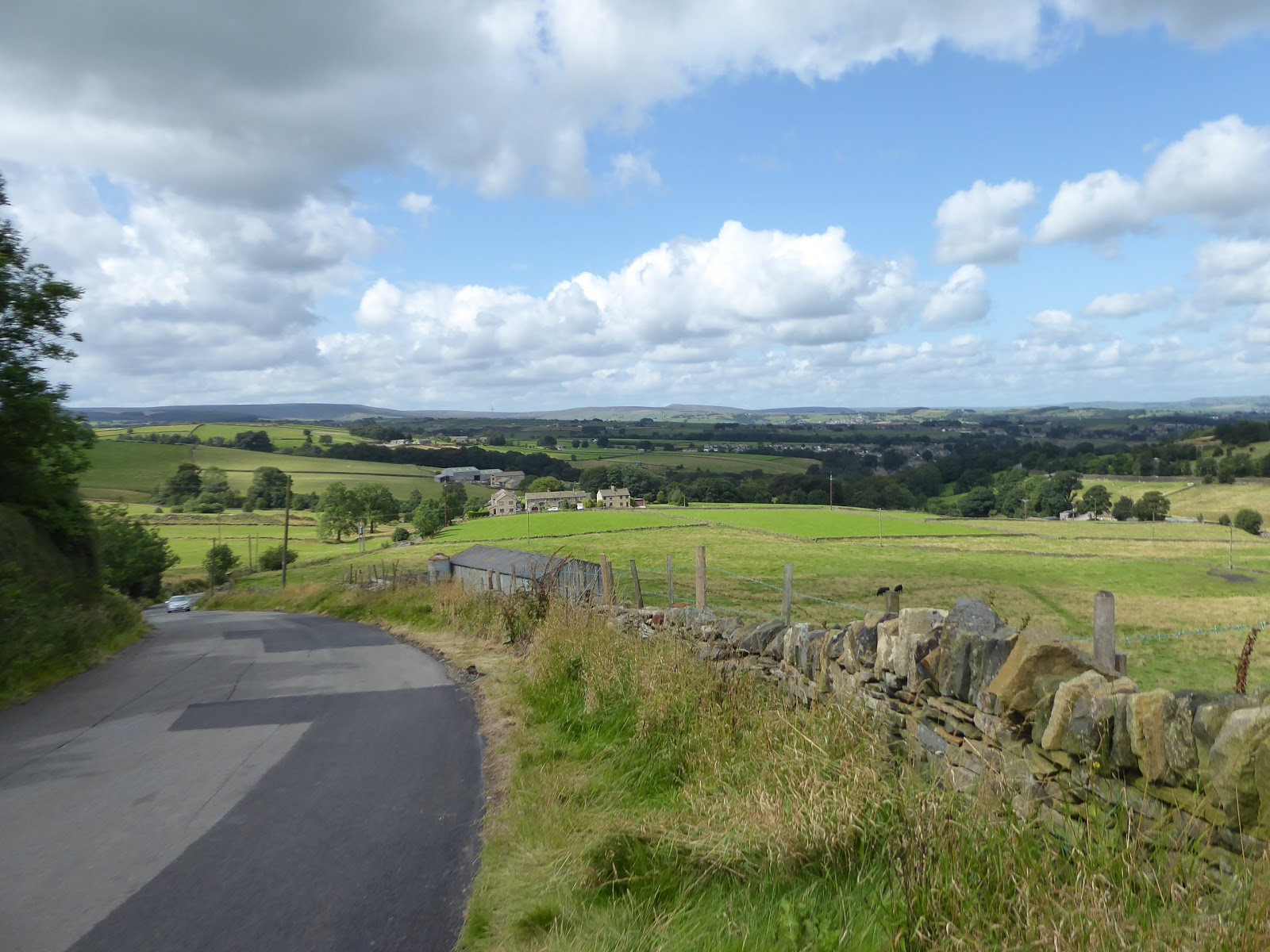
| Dunkirk Crossroads, above the Cawthorne valley. |
Join the B6115 Lower Denby Lane as it settles onto the high brow at the top edge of the Cawthorne valley, of which we saw so much in the earlier going of this year, and it's always going to be one of the fine secret views to be had beyond the borders of West Yorkshire, where the loosely associated farmsteads of Lower Denby seem well situated to enjoy this vista over this still underpopulated corner of the world, and I do hope that that largest of these still goes by the name of Papist Hill, commanding this hillside prominently. We move away from this view over Hoylandswaine and down to Barnsley and move to the westwards trajectory that this day should be taking, passing under the Penistone line at Pinfold Bridge and tangle up with the Barnsley Boundary walk as we go, a trail that we've paced much of along the course this year, and will probably have to be traced properly when we come this way again in five or so seasons time, and this leads us uphill towards Upper Denby, the so far unseen major village of this quarter, where suburbia and council estates have welded themselves on it along the approach up to The George inn by the village green. The altitude over the valley below surely gives it an extra layer of appeal here at the outermost corner of Kirklees district, which is absorbed as we come around past St John's church and the village school, to get a wholly new vista to the south as we pass the suburban edge, looking over the Upper Don region, with Hartcliff Hill and Royd Moor rising above the terrain that has Penistone hidden in it somewhere down there, and you do have to note that the marquee being set up for someone's wedding reception really has done well in its choice of field location. Pace the lane on, elated that by this view over these fields that have become so familiar to me of late, one which is really only seen by the local farm dwellers otherwise, as we set course west towards the turbines on Whitley Heights, as Falledge Lane drops us down towards Ingbirchworth, or the suburban north end of it, on the A629 in the high catchment of the river Don and in South Yorkshire to boot, where we slip onto Wellhouse Lane, by the house with a prominent view that is nonetheless having another property built on its front garden. The suburbia here still seems a bit odd, at a distinct remove from the other towns aroundabouts, but it still seems popular enough, even if it can't keep the Fountain Inn in business despite having the village playing fields next door, and we are soon out of the village again as Annat Royd Lane splits south to cross the dam of Ingbirchworth reservoir, one of the four that sit along the Scout Dike branches of the Don, built to water Barnsley and looking like its right up at capacity, which shouldn't be that surprising after all the rain we've had over the last three weeks.
 |
| Lower Denby hamlet enjoys the best views. |
 |
| St John's church, Upper Denby. |
 |
| The changing perspectives over the Cawthorne and Don. |
 |
| Wellhouse Lane, Ingbirchworth. |
 |
| Ingbirchworth reservoir. |
Its late 19th century construction consumed the intersecting lanes that once ran around this corner, and so we'll be sticking on the replacement roads as we head around it to the south and west, and choose to not join the boundary path as we'll get better views up to the wind turbines from here rather than from behind the tree cover along the shore, and despite its modest size, its a long feeling walk around to its heel where we join the old Horn Lane to make our westwards ascent past Green Gate farm and its many fields of sheep, where we meet a familiar track on Spicer House Lane. Join Brown's Edge Road as it rises up over moorland altitude cross the ridge between the upper branches of the Don, taking us alongside Blackwater Dike, where industrial plant seems to be doing work on a former, or maybe future, dam on the stream in the shadow of the Whitley Common turbines, and as we rise over Brown's Edge the gloom gathers markedly so as we land on the view to the Upper Don proper we've got the dark cloud cover that seems to come with proximity to the Dark Peak. Fortunately, this view over Crow Edge from Lower Maythorne Lane is one we have already appreciated in brighter conditions than this, but the macro-climate of the Peak District and high Pennines is definitely one of those things to ponder as we start the decline downhill, past the road's eponymous farm and below the rising fields on the periphery of Wood Royd Hill, where the local horses all seems to be striking poses for a dramatic silhouette, and we come around to have Holme Moss on the forward horizon and Victoria Crossroads featuring in the fields below. At the steep drop of the lane, by the Wood Royd farms, we bid our farewell to the turbines on the heights, and the upper reaches of the Don, as our attention focuses over the Holme Valley, and we slip onto a rough and deeply rutted byway track to make the shortcut down towards Gate Head, getting some evolving views to the horizons to the north and west, and over the immediate high edge of Cheese Nab, looking forwards to the traversal that we'll be making across its entire length. Pass through the farmyard that has the look of an owner that hasn't thrown anything away in years, and meet the A616 just upstream from the old chapel and its replacement that form the entirety of the hamlet, where we pause with the best view at the top of Gate Head Lane, where lunch is taken, and the valley below is absorbed, as we pick out our path to come over its wrinkles and consider the fact that in spite of its size, it isn't really large enough to accommodate a single trip's traversal, which is wholly why the first two hours of this trip have been in other river valleys.
 |
| The reverse view on Ingbirchworth reservoir. |
 |
| The sunny view East from Brown's Edge. |
 |
| The ominous view west from Brown's Edge. |
 |
| Wool Edge farm, and Victoria Crossroads. |
 |
| The Sunshine over the Holme Valley, from Gate Head. |
We've got a lot of descending to do, as we depart moorland altitude, and set off down the lane that is steep enough to suggest that cycling up it would be no fun at all, to soon meet the hamlet of Barnside, sheltering in the shadow of the valley's elevated perimeter, illuminated by the sunshine as the Pennines proximal weather conditions pass, looking resistant to expansion, althouigh the mill site at it heart has grown into someones's dream rural escape community, which passes in our wake rapidly as the descending lane passes on above Rakes Wood and Mole Clough, in the upper reaches of New Mill Dike. Contextaul views among the undulations are lost in the greenery, and signage indicates when we are due to land in Hepworth village, where the school sits at its southernmost edge, and the rising path of Main Gate illustrates well the fact the suburbia has spread into the upper reaches of the Holme valley, far further than good sense suggests it out to have, consuming the Hepworth Mill site, and the lands of Far Lane, though Town Gate still has all its bucolic charm, and its indications of the domestic weaving industry, which we pass through as we meet the Kirklees Way route and pass the Butcher's Arms. Then take an alternate route through the village past the village hall and old post office, down to the well concealed Holy Trinity church, and then back onto the previously walked alignment, past the bus turning area and down Dean Bridge Lane into the clough of Dean Dike, where the track of 2014 disappears into Morton Wood and we continue to ascend steeply up the other side, among the dramatically placed cottages and up to meet the open fields on the hillside outside Scholes, the third such named place in West Yorkshire, and one of two in Kirklees district. Situated on an altogether flatter stretch of terrain than Hepworth, the suburban growth up here is even more marked and it surely has a friendlier atmosphere today than it would in the dark quarter of the year, and we pass through it southern reaches via Chapelgate, passing its old cottages and school among the century of accrued development, which stretches a distance off to the north, so we'll only be getting the smallest of flavours of it before we pass on. Sandy Gate leads into the green fields beyond, cresting the next rise by the Larch House and Shaley Top farms, and landing us over the main branches of the River Holme, with the Ribble Valley ahead of us, and that means we are also on the elevated field above Holmfirth, the estates of which stretch out onto the apron of greenery, which we descend towards knowing that there'll be quite a lot of down and up to come before we get into the rolls of unfamiliar territory beyond.
 |
| Barnside hamlet. |
 |
| Town Gate, Hepworth. |
 |
| Dean Dike clough. |
 |
| Weavers cottages, Chapelgate, Scholes. |
 |
| Sandy Gate arrives above Holmfirth. |
Taking this route into town could definitely convince you that the pre-turnpike roads really liked doing their own thing without consideration for the traffic that might use them in the future, as Cinder Hills Road meanders its way along the valley side, between many weaving cottages with only the smallest numbers of plots for later arriving houses, descending us through the district of Gully and settling us in above the Ribble Valley and the Dunford Road at only a short remove but at the bottom of a startling drop down from our path. It's a fascinating way to see how the town of Holmfirth grew, spreading cottages up its steep valley sides through the early 19th century, and we could easily continue our descent into the town, but for variety's sake, we stay higher by passing along Back Lane, which passes us above Holy Trinity church level with its tower, and giving us a view down to the Old Bridge Inn and the Picturedrome, while passing around the houses of Bank perched high above the retaining walls of the valley side, getting a grand view back to the high flank of Holme Moss as we pass among more of those tall building that recent historical instruction has confirmed were as much industrial as residential. Drop out on the A635 at a distance above the town centre and cross to find the way down to the valley floor with the steep decline of Bridge Lane, taking us below the imposing plinth on which the town's railway station once stood, and cross the river Holme behind the Co-op and the Fire Station at Bridge Fold, to come around to the A6024 by the former technical college, and pull away from the town as the Huddersfield Road settles into a leafy passage alongside the burbling river, just across from the cricket field that occupies most of the flat land on the western bank. Press on to find no suburban splurge along this stretch, meeting the local Lidl opposite the impressive and still actively industrial Bridge Mill, which we walk around to meet the B6107 New Road to make our push up the far side of the valley, where we meet the suburban growth and a passage that has only a painted on footway, not that most of these houses would appear to be owned by any one too concerned about the lack of walkable access. This leads us up towards Netherthong, a satellite of it's neighbour these days, where there's enough flat land up the hillside to grow estates, but beyond there's a old village of weaving cottages and small mills that probably costs a fortune to live in, and the Town Gate corner throws all the appeal my way before we need to seek a late lunch spot, found below the trees that surround the compact and lancet windowed All Saints church, where we rest before the final push into the unknown.
 |
| Cinder Hill Road, Holmfirth. |
 |
| Holmfirth from Back Lane, with Holme Moss. |
 |
| The Colne Bridge at Bridge Fold. |
 |
| Bridge Mill, Holmfirth. |
 |
| Town Gate, Netherthong. |
As we move into the suburban borderlands, with the finest example of an weaving industrial house so far seen in amongst it, the day starts to warm up again after a gloomy hour or so, and as we press on into the folds of the Upper Holme valley, and it's odd to think that there could be such a large stretch on unseen terrain to be found within the boundaries of West Yorkshire after 7+ years of trail about, but this path towards the Colne Valley will be all fresh to our senses, with Moor Lane forming a frustratingly narrow track along the field boundaries above Dean Brook. There's tight spot or two to negotiate by the roadside farms, before we spy the steeply descending Knoll Lane coming over from Honley to the north of us, passing over the flank of Swinny Knoll, the moorland topped hill of this quarter, which we have been rising towards since Netherthong, though we pass to the south of it as the next vista opens out, with West Nab on the horizon, but with the full reach of Meltham Moor's upland being frustratingly hidden from view as we start or next decline towards Meltham itself, while Slaithwaite Moor and Scapegoat Hill rise on the northern horizon much more identifiably than they would have only a week ago. We soon run into the village of Wilshaw, we seems to be all of a vintage as we pass the village hall and St Mary's court, ahead of the vicarage and church which seems to be far too large to service the community that grew here, and seems suggestive of a Victorian benefactor with a guilty conscience and much as it does one with a sense of altruism, and the later growth on the settlement has kept it at hamlet size, which makes a change in these parts. As we descend towards Meltham, it seems we aren't doing to get a clear look at Deer Hill before we hit the steep passage of Netherthong Road, which the B6107 avoids by taking a snaking route down towards Thick Hollins Dike, deep in its wooded cleft by the former convalescent home and the exceptionally ruined Lane End farm, beyond which we rise to the terraces of Calmlands, at the edge of this most notable of towns in the county that has gone so far unseen on my travels. Mills grew the town in the 19th century, and suburbia padded it in the 20th, now forming a satellite at an even weirder remove than that of Holmfirth, but one that has many points of interest along the main road, as we pass the Oddfellows Hall and the old market place at the top of Town Gate, with the the sentinel hill of Meltham Cop above the town centre, before we pass through the inns and restaurants district, passing the Romanesque St Bartholomew's church and downhill to meet the Morrisons store on the terminus site of the former railway station of the L&YR branch.
 |
| The Dean Brook valley, of sorts. |
 |
| Swinny Knoll. |
 |
| St Mary's church, Wilshaw. |
 |
| The Calmlands Terraces, Meltham. |
 |
| The old Market Place, and St Bart's church, Meltham. |
Across Meltham Dike, it's an uphill push through the rural outliers and suburban accumulation that goes on and on for a while along the sides of Slaithwaite road, reaching all the way to the Traveller's Rest inn, from where a westwards looks gives a proper look at Meltham moor in all its expansiveness, with the rising peaks of West Nab and Deer Hill giving it the familiar saddle shape that is so obvious from the east, while a look back shows up the wrinkles of the Holme valley that we have passed through, and which have also concealed the town below so successfully from all around. We also have Meltham Cop rising to the east, just beating the moorland altitude, and our path takes us over the Catchwater Drain that feeds Blackmoorfoot reservoir with the run off from the high moors to the west, the evolving view of which will keep us company as we push up to Deer Hill Lane End and Queen Mary's farm atop the highest of fields, and crest our way over into the Colne Valley, which reveals some familiar shapes and features on the northern horizon as we bid farewell to the Holme Valley. The Pole Moor masts rise dead ahead, flanked by Slaithwaite Moor and Scapegoat Hill, as we start to come down into the Colne Valley, towards the hamlet of Holt Head, passing the old Sunday School and crossing the noisily churning Bradley Beck as it flows off the moors above, before we split off the B-road as it heads towards Marsden, and carry on down Varley Road as it sheds all the height from the high valley's edge, with the sound of the beck resounding below as it flows through Hey Wood and noting the plethora of high farmsteads around as we descend down Kitchen Clough. The path of the Colne Valley Circular becomes apparent as we enter the lower stretch of the valley, with Slaithwaite appearing ahead under a much greater amount of sunshine than we managed to see on our westbound passage last weekend, meeting the town's edge by Mansergh House and carrying on down among the long, curved sweeps of terraces that coat the roadside all the way down to the A62 Manchester Road, which we cross to meet Lingards Lane, which take us down into the landscape of industrial mills that still endure at the valley floor. On through Slaithwaite's shopping drag on Britannia Road, which takes us over the River Colne and the Huddersfield Narrow Canal, marking only our second contact with the town in just shy of seven years of trekking, and while the sunshine ought to tempt a drink at the Shoulder if Mutton or the Commercial Inn, I'll not be joining this valley's many visiting drinkers and instead push on uphill along the well-shaded Station Road to the railway station, which I've never managed to visit before, and close the day at 4.20pm, unfortunately way ahead of the train, but nonetheless happy that a trip that was 3 miles longer than my last one also managed to somehow be 75 minutes shorter.
 |
| Slaithwaite Road ascends out of Meltham. |
 |
| Meltham Moor, with West Nab and Deer Hill. |
 |
| The Catchwater Drain, and Meltham Cop. |
 |
| Holt Head, above the Colne Valley. |
 |
| Descending Kitchen Clough into Slaithwaite. |
 |
| The River Colne, Slaithwaite. |
5,000 Miles Cumulative Total: 4076.6 miles
2019 Total: 426.2 miles
Up Country Total: 3659.6 miles
Solo Total: 3762.4 miles
Miles in My 40s: 2670.4 miles
Next Up: August Bank Holiday weekend, and outbound on the Holme Valley circular.
No comments:
Post a Comment