15.4 miles, via Graveleythorpe, Halton, Temple Newsam Park (Sycamore Walk, Home Farm,
Mather Wood, Menagerie Ponds, Little Temple, Wilderness Wood, & Charcoal Wood),
Skelton Gate, Skelton Lake, Concrete Bridge, Rothwell Country Park, John O'Gaunts,
Rothwell, Carlton, Lofthouse, Langley, Lofthouse Colliery Park, Outwood, Brag Lane End,
Wrenthorpe, Low Laithes, Shepherd Hill, Flushdyke, and Town End.
Return from Down Country with my brain and legs ready to get back into the walking routine, having spent the midweek celebrating My Mum's 80th birthday by organizing an afternoon tea for her church fellowship on the day itself, no small task as it required two days of labour and another of rest before we headed back Up Country with Mum being particularly pleased with how it all unfolded for her, and with that done we can get back into the walking year, still having to work around train strikes which limits my options again, and as we've done the best park walks in Wakefield district, staying much closer to home seem the best option. So we're walking in Leeds again as my ancient Explorer 289 comes out for probably its last hurrah, bussing ourselves out on the #40 to the east of the city to alight at 9.05am on the A6120 opposite the Cross Gates shopping centre and the railway station where we can start our tilt to the southwest, under unseasonably bright skies, with a pronounced autumnal chill in the air as our path takes us away down Green Lane and Cross Green Lane through the suburban quarter of semis to meet the Victorian townlets that grew beyond the city back in the day, meeting the terraces and town houses of Gravelythorpe on the way up past the Leodis inn, and onwards Chapel Street and the transition into Halton. Beyond said chapel, and the Dial House, the prettiest in this corner, we meet the Halton High Street, all of a 1980s redevelopment style that we're thankfully not doing any more, strung along the Selby Road, which we cross to head south, down Irwin Approach behind Lidl and alongside the local recreation grounds to meet Temple Newsam Road, leading us down through the suburbia and into the spread of Temple Newsam park, with our park walk arriving at the start of the day rather than the end, shadowing the perimeter of the golf course and sticking to the shaded pavement below the canopy of autumnal leaves as we are led up to the eastward turn and the reveal of the view back across south Leeds (one of the few places where Morley can be placed in the landscape at a significant remove). Press uphill on a familiar route past the running track and on to the Sycamore Walk to pass through the shade towards the heart of the park, arriving to the north of the Jacobean house complex and meeting the track that leads us down between the stables block and the Home farm, observing just how many folk seem to be out early to make the best of this sunny Autumn morning, and find a park run going on along the track on the fringe of the east lawn, which we'll not tangle with as we press east still, down the side of Mather Wood to the revelation of the wild woods on the rise beyond, where we have a single focused target, to be found beyond the fall of the beck that feeds the Menagerie Ponds.
 |
| The Cross Gates Centre. |
 |
| The Leodis inn, Gravelythorpe. |
 |
| Dial House, Chapel lane, Halton. |
 |
| Temple Newsam Road. |
 |
| The Sycamore Walk. |
 |
| Mather Wood and the concealed Temple, Temple Newsam Park. |
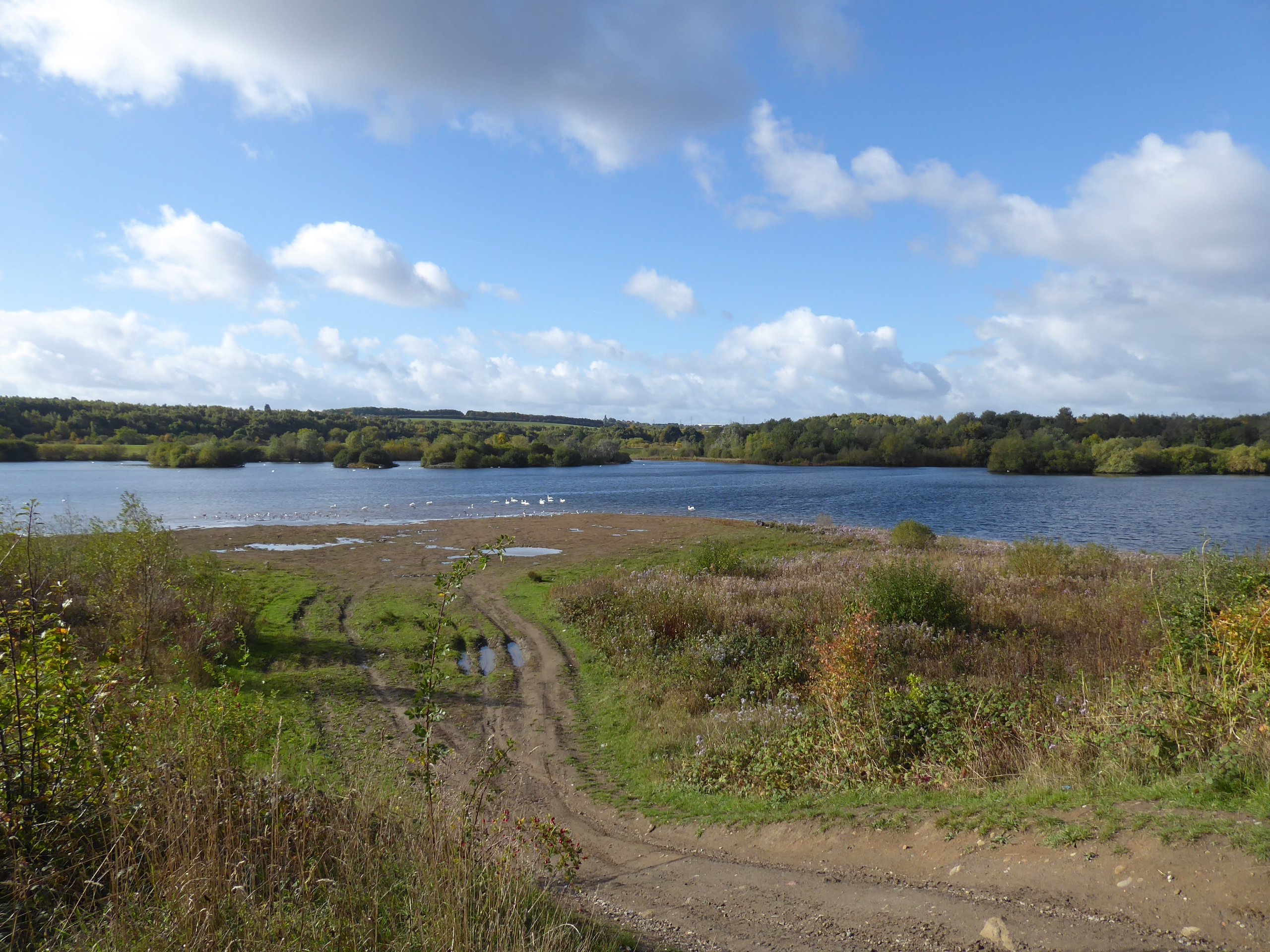
A rough track leads uphill along the edge of the Elm & Oak woods, to meet the elevated track that leads to the Little Temple, Capability Brown's picturesque 18th century folly feature that cuts a rather sad sight behind it protective fence, on a bluff presenting a fine view back to Temple Newsam House, which we descend from with many further paths presenting options that have to be discounted for today as we double back on the track through Wilderness Wood and Charcoal Wood to find us the track that leads south, below Dunstan Hill and shadowing the stream that got moved by the development of Temple Newsam Colliery, itself now reclaimed into the parkland. Benches provide a spot for some early elevenses before we press on to the day's actual trail, feeling like we haven't given the parkland enough due as we depart below the M1 to find that the bridleway that shadows Pontefract Lane is closed due to the reclaimed workings at Skelton Gate getting excavated again, which sends us onto a temporary diversion that's kinda present on the map and looking rather permanent on the ground, south between the beck and the slightly redeveloped plots to the east, up towards the Biffa landfill site that may have recently ceased operations, before directing us west on a more indelible track, on what might have been a rise between different opencast workings in a landscape that I really haven't been able to uncover a history of. The diversion eventually leads us back to the side of the stream, in the shadow of the Skelton Lake services, which have landed here since my previous visit to this corner, and we're back on track as we join the bridleway that leads us around Skelton Lake, a reclaimed pit that's now a nature reserve and flood reservoir, with the high track keeping us in the shade of the trees and quite a way above the shore as it takes us south towards the side of the river Aire, landing us on a high embankment which we press westwards along, noting that almost nothing in this landscape is naturally occurring as lake, river and the surrounding woodlands have all been manipulated by human industry.
 |
| The Little Temple, Temple Newsam park. |
 |
| The path south from Charcoal Wood. |
 |
| The Bridleway Diversion, Skelton Gate. |
 |
| Among the reclaimed opencast pits, Skelton Gate. |
 |
| Skelton Lake. |
 |
| The River Aire-side Embankment, Skelton Lake. |
Pass over the downfall of Wyke Beck and note that this landscape has become much more formally accessible since our 2014 visit, as a new footbridge takes us over the Aire on a path that joins to the towpath of the Aire & Calder Navigation channel, where rowing is observed before we rise to the former Skelton Grange power station branch and have the Concrete Bridge lead us over the canal to a new path that shadows it east, passing below the railway branch route that we paced eight years back, before we turn under its bridge and that on the Midland Line coming down from Leeds as we are lead uphill between the plots of Rothwell Country Park, on the former colliery site. That gets us onto a southward trek, ending the odd meandering of the early going, and we might explore further here too if we didn't have a distant destination, so we'll press uphill with Bullough Lane, getting the upstream views on the Aire valley towards Leeds before we pass Haigh farm and take First Avenue along the edge of the John O'Gaunts estate, spilling out onto the A639 Leeds Road, the first point of contact with our 2022 bubble since the start line, where the dual carriageway is crossed to enter suburban Rothwell, dropping downhill with Styebank Lane as it crosses Haigh Road and passes the cemetery on its long run down to St Mary's RC church. Take a westward turn onto Park Lane to shadow the northern edge of Springhead park, and walk upstream with Oulton Beck as we're drawn into the older centre of Rothwell along Park West and Ingram Parade (though the main shopping drag is Commercial Street, where none of our local paths have ever landed), passing behind the Morrison's store and emerging down from the White Swan Inn and Holy Trinity parish church, to cross Church Street and follow the suburban fronts on Stone Brig Lane as it leads us to the green passage of the bridleway that continues upstream with the beck, passing that local empire of poly-tunnels on the rising hillside again and turning south to lead us to the A654 Leadwell Lane at the town's most westerly point.
 |
| Concrete Bridge, and Rowing Action. |
 |
| New Canalside Path, on the south bank of the A&CN. |
 |
| Rothwell Colliery Country Park. |
 |
| The upstream view to Leeds from Bullough Lane. |
 |
| Styebank Lane, Rothwell. |
 |
| Holy Trinity, and the White Swan, Rothwell. |
 |
| The green path by Oulton Beck. |
Stainton Lane continues us on our southerly push, soon enough landing us in Carlton village after bare minutes spent in the countryside, taking us around the very sharp right turn onto Main Street where we can track past the Unicorn inn, the Social Club and the Millennium Green, before taing the turn onto New Road to pass the village school and note the 'Coronation Street' that I'm certain I must have commented on when trekking the Leeds Country Way 10 years ago, before we pass out south with Town Street, past the cricket and sports fields and the Green Field produce factory as we shift onto Cemetery Lane and follow the rise among the fields to meet the broken bridge on the E&WYUR's Newmarket colliery branch. Rise on past Lofthouse cemetery and get the last teased views of Leeds's high towers as we crest, a lot like we did from the viewpoints on our prior pair of walks from much further away, rising on into the village to cross Green Lane and tie ourselves even more firmly to the 2022 bubble as we carry on up Carlton Lane to meet the A61 by the Nisa Store, and match the passage of the season opener as we follow the Leeds Road south, past Christ Church and over the M62 to land ourselves on what ought to be the Aire - Calder watershed as we progress on past the Methodist chapel, the Royale Cantonese restaurant and the concealed Lofthouse Hall farm, before taking a right onto Westgate Lane to join the Wakefield Way route as it leads us southwest-ish towards the suburban hamlet of Langley. The declining path beyond leads us across the abandoned Lofthouse Hill golf course, and down through a deep groove that hides our whereabouts well as we come down to Lingwell Gate beck, shockingly flowing Aire-bound still, which is crossed to enter Lofthouse Colliery country park, the third (or fourth?) on the day, where the stepped track ahead leads us up to the plateau covering the colliery spoil tips, where autumnal colours abound and we can feel relatively close to home, being in proximity to the Outwood depots and the East Ardsley nab that we observed from afar over the last two weekends, though we'll not use the picnic table up here as it's a bit brisk and more shelter can be found on the far side, by the colliery memorial at the side of the West Riding line.
 |
| The Unicorn inn, Main Street, Carlton |
 |
| The E&WYUR on Cemetery Road. |
 |
| The A61 Leeds Road, Lofthouse. |
 |
| Westgate Lane, leading to Langley. |
 |
| The path to Lingwell Gate Beck |
 |
| Lofthouse Colliery Country park. |
Late lunch is taken and train are observed passing despite the strikes, before we move on down the perimeter oath that leads to the playing fields and into the thicket by the railway-side that draws us down to the southbound side of Outwood station, and the edge of the 2022 bubble as we match April's way out to Lingwell Gate Lane and also a reverse performance of a route from late 2014, which is why we're doing this walk southwards, starting with the park walk finale and having the low sun in our eyes for the next couple of hours as we match pavements though Wakefield's north-western quarter down Potovens Lane, past Outwood park, the original(?) Outwood Academy, and over the West Riding Line and the A650.We meet the Bradford Road at Brag Lane End, where Declan's is still in its second-hand business, where Wrenthorpe Road beyond leads us towards its eponymous village (also known as Potovens, it seems) which we'll take greater care to look at this time around as we avoid the green paths and stick to the pavements, which take us past the Sports & Social Club, Gills Mini Market, and the parish church of St Ann and their Methodist neighbours, before the drop down to where the village heart feels like it ought to be, passing the New Wheel and the New Pot Oil inns before taking the turn onto Wrenthorpe Lane that takes past the village hall and down to the Calder-bound Balance Beck, next to the community orchard. Then it's uphill again, rising by Hall Cliffe school and the Sunny Hill villas in their now-suburban setting, where the view north reminds us of our relative proximity to home, and our route from eight seasons back is resumes across the suburban top and down among the terraced runs on the way down to Batley Road, where the suburban creep of Wakefield west from Alverthorpe seems to be continuing, and the Lofthouse Colliery disaster memorial is noted again, in the rough location of the fatalities a solid hour's walk away from the pithead, where we re enter the countryside, getting sight of our finish line as we press west towards Kirkhamgate and then drop downhill with Park Mill Lane, onto a footway-less road after so far travelled on pavements and paths.
 |
| Lofthouse Colliery Memorial. |
 |
| Autumnal Colours along Potovens Lane. |
 |
| Wrenthorpe Sports & Social Club. |
 |
| The New Pot Oil inn, Wrenthorpe. |
 |
| Sunny Hill, Wrenthorpe Lane. |
 |
| The creep of suburban Wakefield along Batley Road. |
Down through the fields we go, to bottom out at Rushy Beck, and then rise beyond through the mostly lost farm hamklet of Low Laithes, where its eponymous farm is the main survivor, as the clubhouse of its equally eponymous golf course (and I think I've said 'golf course' more times today than I have across all of South Yorkshire trekking this year), where multiple trails have taken us, beyond which we pass over the M1 again, five junctions south of where we last saw it, with Eat Ardsley and Tingley lingering on the norther horizon as we get the first feeling of proper Autumnal chill setting in as cloud obscues the afternoon sun to rob the air of all the radiant heat. Finally on an unseen path beyond and having risen level with nearby Lodge Hill, we get our westerly view that puts us in the proximity of Ossett as Holy Trinity church looms large on the immediate horzon, and we turn south with the lane as it loops around to pass over the A638 bypass road, to bring us down onto the old Wakeflied & Dewsbury Road at Shepherd's Hill, we we progress west again, downhill past Flushdyke school and on along the B6129 where one might imagine the presence of the completely lost railway line passing over the road into Flushdyke station, before we press on with the lane, where light industry and retail seems to have replaced most of the village over the last century, with only a few reisdential outliers remaining. It's all greater Ossett now, of course and our final turn south comes at Dale Street and Town End, where a ribbon of Victorian development grew away from the centre to the south, which we'll rise and crest amongst as we pass the Mews inn, the old fire station and a whole bunch of villas before we arrive by the Thornes House old chapel and the grounds of Ossett United on Prospect Road, with the town, and more importantly, the bus station lying beyond, where the 2022 bubble can meet a new boundary as a loose end is tied off at 3.15pm, not too far ahead of the #126 bus, though the dawdlebug ride home to Morley via Wakefield does give you the feeling that it have literally been quicker to walk.
 |
| Park Mill Road descends to Rushy Beck, and rises to Low Laithes. |
 |
| My local-ish horizon, above the northbound M1 |
 |
| Holy Trinity Ossett dominating the local horizon. |
 |
| The missing railway bridge on Wakefield Road, Flushdyke. |
 |
| The Mews Hotel, Dale Road, Ossett Town End. |
 |
The home of Ossett Untied, Prosepct Road
(which isn't the Chicken Hut, if you're wondering). |
5,000 Miles Cumulative Total: 5888.9 miles
2022 Total: 600.2 miles
Up Country Total: 5,408.2 miles
Solo Total: 5553.3 miles
5,000 in my 40s Total: 4478.7 miles
1,000 km in 2022 Ticker: 965.2 km
Next Up: Returning to South Yorks for the traversal of Barnsley and Doncaster boroughs.


No comments:
Post a Comment