17.7 miles, via the Glassworks & Alhambra centres, Measborough Dyke, Hunningley,
Stairfoot, Ardsley, Wood Lathes, Highfield, Darfield, Millhouses, Cathill Roundabout,
Billingley Green & Bridge, Highgate, Goldthorpe, Harry Ottley Plantation, Hickleton,
Marr Moor, Marr, Hills & Holes, Ducker Holt, Scawsby, York Bar, H&BR branch,
Willow Bridge, Crimpsall, St Mary's bridge, Marsh Gate, North Bridge, Grey Friars,
Market Place, Christ Church, Civic Quarter and Spring Gardens.
If passing the 600 miles marker makes for a successful walking season, we're already there having passed it by the width of a conversion error last weekend, for the first time since 2019 after two pandemic blighted seasons, but the reality stands that we still have four weekends to go on the year, with two more mileage targets looking immediately due as a new personal best and the 1,000km barrier should be attainable soon enough, and we've still gotten plenty of miles left on the slate too, as there are still four trips in South Yorkshire plotted, landing somewhat benind schedule thanks to having already done most of my end of season park walks on our various train strike weekends. So we find ourselves in the middle of October, looking to the long route that stitches together the pair of boroughs below West Yorkshire, which might transpire to be my second longest excursion of the year, alighting at Barnsley to depart via the Interchange exit at 9.20am, already adding minutes to the trip before we've even gotten started, emerging onto Midland Street and starting off south, towards the old road junction that's now lost by the retail developments in Barnsley town centre, passing through the May Day Green square to note the first Covid Pandemic memorial that we've seen on our travels, and then make our way through the GlassWorks and the Alhambra shopping centres, before we emerge under the traffic island below the tanglings of the A61 and A628. The left hand path takes us on to the stub end of Doncaster Road and the southeasterly press that will be the feature of most of the day, past the shopping parade and up to the view across to Oakwell stadium as we join the A635, pressing on through Measborough Dyke with its stone terraces surrounding the redbrick church of St Peter & St John, with the bright skies reveling the waning gibbous moon as our companion feature as we drop down meet the A6133 as it merges in below Barnsley cemetery, and then we rise again up Measborough Hill to meet Kendray Hospital at its crest, across the way from the old Oaks Colliery disaster memorial, situated just south of the site of the loss of 361 lives in Decemeber 1866.
 |
| The Pandemic Memorial, May Day Green, Barnsley. |
 |
| The Alhambra Cat, Barnsley. |
 |
| St Peter & St John, Measborough Dyke. |
 |
| The Oaks Colliery disaster memorial, Measborough Hill. |
An estate landscape follows from the crest down to the Doncaster Road railway bridge, which is passed under before we decline further, through the renewed stone terraced landscape of Hunningley, seen on our previous visit to town, which leads across the old canal passage that's lost in the landscape ahead of the tangle with the A633 and the plethora of lost railways that passed through this hillside depression at Stairfoot, beyond which the A635 becomes a dual carriageway and rises sharply uphill towards Ardsley, the westernmost suburb of greater Barnsley, which hints a rural sort of vintage on the rise up to the Old Chapel antiques centre. The climb levels off to pass Ardsley Welfare park and then rises again to pass Christ Church, the Oaks WMC and the Kamenka furniture store and coffee shop in the old pub, where a gaze back reveals a well illuminated view of Barnsley's high points, before we pass the grounds of the lost Ardsley House, and the extant Manor farm, as well as the Barnsley Crematorium as the suburban band thins to give us a theoretical view south, across the Dove valley which is mostly concealed by trees and the glare of the low sun, which looks like it's going to be a bit of an annoying presence on our horizon as we press eastwards, to the end of the suburban ribbon and past Wood Lathes farm, departing Ardsley and being soon greeted into Darfield. We're nowhere near that village though, as we settle onto the wide footway alongside the Doncaster Road, elevated among the fields on the rib between the Dearne and Dove valleys, while not rellay geting the vista such a locale should provide, as the sun glares off the damp tarmac, and trees and hedges deny us all but the most fleeting of contextual views, toward Tyers Hall and the Houghton Main windfarm in the north, before we pass the Strawbridges Garden Centre and Saltersbrook Road starts to meander us into greater Darfield, where we sneak our first sight of the Hampole and Marr windfarms on the distant eastern horizon, before coming in by the cemetery and its surrounding of terraces and semis at Highfield.
 |
| Hunningley High Street and the descent to Stairfoot. |
 |
| The rise from Stairfoot to Ardsley. |
 |
| The view back to Barnsley from the Oaks WMC, Ardsley. |
 |
| Ardsley's suburban ribbon on Doncaster Road. |
 |
| The low Sun hangs over the Dearne & Dove watershed ridge. |
 |
| The hidden terraces of Highfield. |
A familiar bench provides an elevenses spot on the Edderthorpe Road corner before we resume, scratching the edge of Darfield village again as the A635 presses us past the Nanny Marr Road corner for a third time and then downhill again past the grounds of Middlewood park and the Thaal Indian restaurant in the old Bridge Inn, before we cross the shaded river Dearne and carry on into Millhouses, beyond the tall terrace in the woods behind Quarry Hills and around to the remains of the overhead passage of the North Midland Mainline and its access to the goods yard at Darfield station, making for some impressively large abutments ahead of the renewed rise through the village. Past the Mumbai Lounge, in the old Station hotel, and the small closes of council houses, we can rise beyond the mental limit of greater Barnsley and set out onto the passage above the eastwards passage of the river Dearne, soon coming upon the Cathill Roundabout, with Yorkshire Warm Roofs surely occupying an old Little Chef, as we match recent footfalls up to the A6195 crossing before we press on east feeling an unseasonable warmth from the sun as we are carried on along the footway, passing to to the north of the path that took us through the rough lands into Bolton upon Dearne and below the rolls of the fields below Billingley, noting the lay-bys that indicate some subtle road redirection in the past. At Billingley Green, across the way from Rose Valley farm and Woodbine Cottage, the Doncaster Road re-associates us with our path to Goldthorpe, and it's a decent distance to retread, albeit much bright and a lot less alien than it felt back in June, as we sidle down to the crossing of Carr Dike at Billingley bridge, noting the plot of Christmas trees adjacent to it, and feeling the presence of the nearby distribution depots as we rise up to the Hollygrove Roundabout, as the heavy good traffic intensifies while we quit the A635 at the start of the Goldthorpe bypass and carry on with the Barnsley Road beyond the Aldi store and past the terraces at Highgate and up to the thrice-seen crossroads by the primary school.
 |
| The old Bridge Inn, Darfield. |
 |
| The North Midland mainline remnants, Millhouses. |
 |
| Cathill Roundabout. |
 |
| Lay-bys indicate road straightening on the A635. |
 |
| The Christmas Tree field, at Billingley Bridge. |
 |
| Meeting Highgate's terraces, again. |
Pass the Highgate WMC and over the Swinton & Knottingley line above Goldthorpe station, to start to tangle among the council houses of this post-mining village, up to where the H&BR and the DVR scoured their way across the landscape, forming the feature Railway Cuttings park that isn't open on a Saturday, where I'd swear a vintage house or two endures ahead of the terraced run of the B6068 through the considerable village Main Street, which once had two cinemas among it run of stores that's honestly larger then it needs now, around the civic centre and police station at the top of the High Street, beyond which we meet the primary academy and the moon still hanging in the early afternoon sky above the church of St John & St Mary Magdalene. As the brick terraces resume around the old Goldthorpe tavern and the local parklands, hints of continued suburban development rather refocus the impression of the depressed mining town, and only the looming wooded presences of Phoenix Park and Goldthorpe Colliery woods beyond the village keep the idea in the mind as we rejoin the countryside, looking back to note the water tower that only stands prominent when viewed from afar, and following the Doncaster Road as it runs back to meet the bypass, taking care to find the original track through the top of Harry Ottley Plantation before we get back onto the A635 and start the wooded rise up towards Hickleton, enjoying the shade and the autumnal colours as we follow the footway that keeps us away from the traffic. Passing into Doncaster borough and around the western edge of Hickleton Park, we land in a familiar locale again as we pass the end of Lidget Lane and enter this stone and tiled village that makes me wonder how such Cotswolds-looking settlements managed to land on this minor South Yorkshire upland, where we'll take a lunch break in the memorial gardens to take a last look at the vanishing moon, before we press uphill past the village club and the parkland gatehouse, taking our last look at distant Barnsley in the west and then pressing on past St Wilfred's church and the monumental cross at the junction, where we lose our pavement and start the plausibly treacherous walk alongside the A635 on the passage across Marr Moor crammed onto the narrow verge on the tree lined rise up toward the road summit.
 |
| The Dearne Valley Railway bridge, Goldthorpe. |
 |
| Goldthorpe Main Street. |
 |
| Goldthorpe Water Tower. |
 |
| Shade along Doncaster Road, on the rise to Hickleton. |
 |
| Hickleton Memorial Garden. |
 |
| Taking the footway-less passage of the A635 to Marr Moor. |
It's a road walk that could easily have had me spooked, but despite this A-road being a red route, with more than its fair share of lorries pounding along between the various depots in this area, the sightlines are good and the verges wide enough to not feel threatened as we progress up to the crest and get our view that locates us, north of the Marr windfarm and Melton Wood, and south of Brodsworth Park, with its neighbouring colliery remnants loitering in the northeast, and our initial elevation gives us an horizon to scan, picking out the few high points in the east as we progress past the Marr Moor lodges, and switch sides on the lane as the verge gets testily narrow. Pound on, checking off Drax power station, Askern water tower and All Saints Woodlands' spire off the spotters log as we descend gradually, with the trucks whisking past just that bit too close to the back of my head for it to be comfortable, as we come down onwards Marr village, occupying the odd place at the heart of this wide level plateau, which can't even be considered as a suburban aberration around the road junctions and the Marr Lodge carvery, as the Manor farm and the parish church of St Helen are both medieval establishments, and we'll detour to the latter of the these for a late refreshment break to get some fortification before we head off the local pavements that have been most welcome. Rejoin the carriageway walk once we've traced a way beyond the suburban ribbon, finding much less space to walk on this eastern portion, but the distances between the features aren't too great, so it's off the verge and scurry on to get the lay-by at Hills & Holes plantation, and thence another run to get to the Marr Grange driveway, where another look for the lost alignment of the H&BR South Yorkshire Junction branch has to be in order before we make for the carefully chosen passage under the A1(M) at Junction 37, beyond which we find another narrow verge to enter the woodlands at Ducker Holt, and conspicuously rise up with the Barnsley Road through the heavily shaded remnants of Leys Hill quarry.
 |
| Marr Windfarm and Melton Wood. |
 |
| Brodsworth Park and Colliery. |
 |
| Marr Village. |
 |
| St Helen's church, Marr. |
 |
| Hills and Holes plantation. |
 |
| Ducker Holt Woods, and Leys Hill Quarry. |
Level fields and a procession among the hedges follows, with the impression of being in the vicinity of greater Doncaster coming on quickly as we engage in the year's last bit of Goole-spotting on the north-eastern horizon, before we draw in to the Sheep Walk Lane corner, where we regain a footway (and feel secure that we don't have to approach walking that length of the A635 again), and make happier footfalls through the old Scawsby hamlet, around its Hall and farmstead, and the Scawsby Mill pub & grill, sat at a short remove from the meeting of the formal edge of the city, past the Stone Hill and Ridgewood schools, by which a turnpike vintage milestone indicates us the 13 miles we've travelled so far. Suburban Scawsby fills both sides of the lane beyond, while dark clouds gather on the western horizon, looking to claim the nice day that's we've been enjoying since setting out, and thus we'll feel like we ought to be getting a move on as we pass along the boulevard formed by the adjacent Westerdale Road, with the gloom overwhelming us quite abruptly as we make our passage by Barnsley Road Park, the Aldi store and the church of St Leonard & St Jude, so much so that a wholly different days seems to be taking place as we come past Scawsby Saltersgate school and the Sun Inn at the end of the A635, and our inbound route of choice takes us on over the A638 dual carriageway at York Bar, just as the most unwelcome rain starts to fall. Hurry on along Watch Hall Lane to get to the Doncaster Greenway, and finding that the shower breaks off as soon as we're under the cover of greenery, and it's brightening again as we emerge to pass across the H&BR/GCR joint line (to remain unpaced in 2022, sadly) and set off down the railway spur that once led to the H&BR's Doncaster goods terminus, through the woodlands in its old triangle junction and shadowing the terrace ends off York Road as it passes over Swaith Dike on a low flood viaduct that has to be deliberately sought to admire its blue-brick construction, before the Tattersfield Park urban wild patch takes over, admirably not claimed by development, unlike the goods yard itself, now under the Centurion retail park.
 |
| Scawsby Hall. |
 |
| The Milepost at Ridgewood School. |
 |
| Suburban Scawsby on the Barnsley Road. |
 |
| Watch House Lane, Doncaster. |
 |
| The Doncaster Greenway, H&BR goods line on the left. |
 |
| The Swaith Dyke Flood Viaduct on the H&BR branch. |
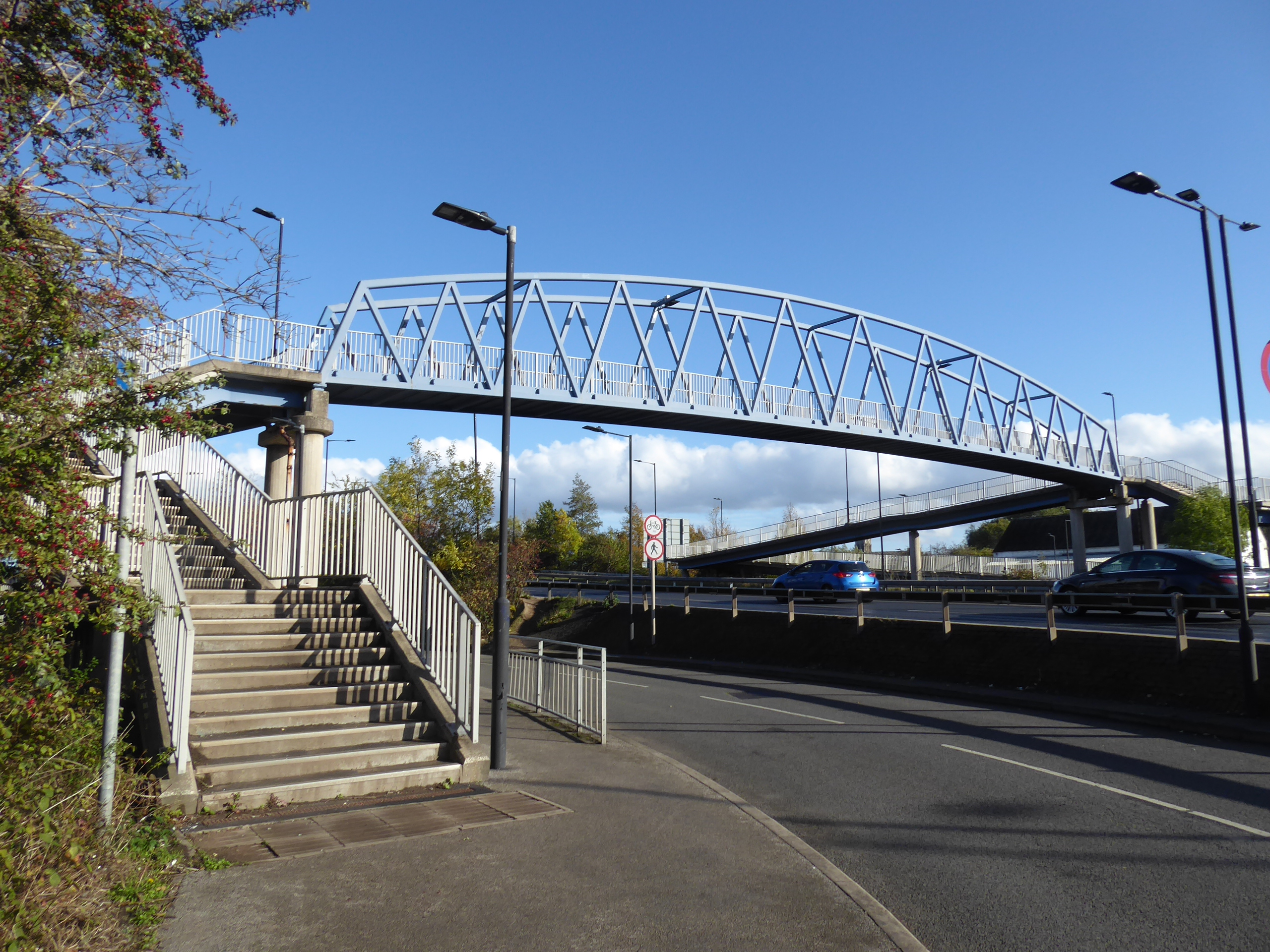
Landing on the Bentley Road again, we're on familiar paths once more we move to pass under the railway at Willow Bridge and over the A19 bypass road via the footbridge over to the Three Horse Shoes corner, while our attempt to find an alternative passage into town via Power Station Road and the bridge over the Don to the Crimpsall island comes to nought as that's a route only accessible to HMP Doncaster, and thus we have to track back to cross St Mary's bridge to vary our approach only slightly by heading down the old alignment of Marshgate to meet the Navigation by the New Cut lock, and then rise to pass over North Bridge via the spiral staircase. Across canal and station throat, we then descend as we rose to the Grey Friars side, to start another town circuit as there's still enough afternoon sunshine for it, shadowing the Navigation again to the turn by Doncaster Minster, which glows with an apparent aura, ahead of our passage over the A630 by the Premier Inn, to follow High Fisher Gate down to the Market Place, which is shutting up for the day, and passing around the cast iron Wool Market, which is just getting going with Saturday night traffic, beyond which we have to negotiate a way along Market Road and East Laithe Gate to land in the high Victorian square at the nd of the Thorne Road which has Christ Church at its heart. Then it's over Georgian South Parade, on the old Great North Road, and on down Waterdale, into the Civic Quarter to this time notice that the Doncaster Girls School facade is preserved within the Danum Museum, the Blues Brother apparently perform outside the Harewood inn, and the new plaza between the council offices, courts complex and theatres is appropriately named Sir Nigel Gresley Square, from whence we make our final route choice down the back streets of College Road and Spring Gardens, which leads us back to Trafford Way, across from the railway station, and below the ,local history mural on the end wall of Sainsbury's, which hasn't quite gained the attention that 'Building Speed' has on my prior quartet of visits.
 |
| The A19 Footbridge. |
 |
| The inaccessible Don Bridge to Crimpsall island. |
 |
| New Cut Lock, on the Don Navigation. |
 |
| Doncaster Minster, with Aura. |
 |
| The Wool Market, Market Place. |
 |
| Christ Church, Thornes Road. |
 |
| The Danum Museum (with Girls School). |
 |
| Doncaster Central Library. |
 |
| The Trafford Way Mural, unfortunately obscured by trees. |
Only a few steps remain to be made after that, to wrap the excursion at 4.20pm, with not many viable minutes of afternoons sunshine left, having stretched out the day by 40 minutes longer than was honestly necessary, but usefully applied at the end of this trip, as they've boosted me over my annual personal best mileage, while having also proven that mid October isn't the wisest time to be throwing down the second longest walk of the season, as we don't have enough time or energy to loiter for a proper train-spot as the many services on the ECML pass by, especially when the cheapest ride homeward is only seven minutes distant.
5,000 Miles Cumulative Total: 5906.6 miles
2022 Total: 617.9 miles
Up Country Total: 5,425.9 miles
Solo Total: 5571 miles
5,000 in my 40s Total: 4496.4 miles
1,000 km in 2022 Ticker: 993.7 km
Next Up: #1000kmin2022 becomes a reality.


No comments:
Post a Comment