15.8 miles, via Turnhole Clough, Saucer Hill Clough, Boulsworth Dyke, Will Moor,
Thursden Wood, Thursden Brook, Park Wood, Pike Lowe, Holden Clough,
Swinden Reservoirs, Lee Green Reservoir, Swinden Water, Houghton Hagg Wood,
Brun Valley Country Park, Bank Hall Park, Leeds & Liverpool Canal (Burnley),
Reedley, New in Pendle bridge, Spurn Clough, Moor Isles Clough, Pendle Hall bridge,
Ightenhill, Habergham, and Pit Plantation.
 |
Long Distance Trail means Selfies!
#3 at Wycoller Country Park |
Two rest days are taken from the trail in the midweek period of 2021's Spring Jollies at Home, to allow time for other activities like shopping, spring cleaning and generally getting our house in order before The Way is rejoined at its most awkward extremity, but not putting Mum too far out of the way on another day out for her while performing Parental Taxi duties, dropping us off at 9.50am under much brighter conditions than we saw three days back above Wycoller's valley, at the country Park's Haworth Road car park, where we can both regard The Atom in a much more positive light than we did on Monday, as sunshine really elevates the views from the Panopticon. Looking forward to a whole day of walking into the previously unknown in Lancashire, our first in a long while, The Way needs to be returned to by the descending path down to the hamlet, giving us restored views over Pendle Hill and its borough downstream as we return to Wycoller Hall's ruins where we can poke around the remains of this late 16th century hall, dismantled in the early 19th century, meaning we have the same sort of edifice to regard as Charlotte Bronte supposedly did, as we wander among its rooms and around to the aisled barn, and that's going to be about it for the Bronte connections as The Way seems to have fallen like the Hadrian's Wall Path, having crammed most of its points of interest into its middle portion. We'll need to trip around the hamlet before we go, tracing the track to its northwestern end by Lowlands Farm, and the pricey new cottages that have been added in here, then coming back up the main street, crossing over the beck as we go and quietly marveling at how expensive and Cotswolds-ish it all feels, ahead of us meeting the Packhorse and Clapper bridges again and heading on upstream along the metaled path on the southern bank, through some willow tunnels and across a small wetland reserve as the settlement falls away behind us.
 |
| The Atom, in brighter conditions. |
 |
| Wycoller Hall, and the Clapper and Packhorse bridges. |
 |
| Wycoller Hamlet. |
Get back on track with the official route of The Way by returning to the correct side of the beck via the super ancient, like maybe 6,000 year old, Clam Bridge, via it single gritstone block and enjoy the last of the shade as it covers the lane, leading us up to the path division and the rise above the converging streams, landing ourselves on the tongue of land between them as we rise up towards Dean House farm, elevating ourselves above the cleft of Turnholes Clough and returning us to the moorland landscape we previously came through, to the west of the English watershed. Beyond the farm, the path crosses open rough pasture, passing around a small quarry and giving sight to the rock outcrops across the valley, and up beyond Brinks End farm, the last on this hillside, to the mass of the Boulsworth Hill upland that lies beyond, rising across the fields of sheep to meet the hard track that delves into this landscape on the western Pennine edge, which we'll be sharing with the Pennine Bridleway again as it presses southwest, ensuring a decently marked route as we head into the Forest of Trawden. There's nary a tree to be seen out here of course, as a sole quartet sit on the moorland edge above our passage over Turnholes Clough, via a bridge to ensure the track for cyclists and equestrians doesn't need to ford the stream, and we rise up to meet moorland altitude as we pass alongside the descending watercourses, draining off the moors that rise up the sides of Crow Hill and Boulsworth Hill to the south of us, while the views in the other directions are concealed by a high wall and the rise of Flake Hill Moor, giving us a single aspect to regard pushing forwards. We pass the and of the gravel track and meet ancient flagstones as we rise on above Saucer Hill Clough, illustrating just how old of a route this is as it presses along the moorland fringe, with the recent rainfalls still showing up the problem of water puddling in literally any depression that it can find, while we look up the 200+ m of slopes up to the 517m Lad Law summit to the south, reminding us that the Calder valley watershed isn't much more than a miles to the south of us, as we all so spot bench marks carved into the setts, matching the 324m and 306m spot heights indicated on my trusty and well-worn OS OL21 map.
 |
| Clam Bridge. |
 |
| Turnholes Clough. |
 |
| Crow Hill. |
 |
| Boulsworth Hill. |
The path declines and the wall drops, putting Pendle Hill back on the horizon as we get the field landscape to the south of Trawden village butting up to the PBW route, giving us another road quality surface to walk on as the path undulates over the waters that run straight down the face of Boulsworth Hill allowing us the chance to ponder the possibility of traversing our way up from the east and coming down this western flank later in the year, as there's a pair of permissive paths on this side, the first of which is met by Spoutley Lumb barn. The renewed views to the north give us another aspect on Pendle Hill, and the rolls of hills that reach out from its northern end, Wheathead Height, Jackson Slack and Weets Hill as they spread their upland outwards, ahead of us meeting the farmstead at Boulsworth Dyke, and the plantation over the covered reservoir on the moorland side, rolling further with track as the streams continue off the moors, and passing a few people travelling on foot and on wheels as they travel north, and we peer over the walls again to attempt to locate the the settlement that lies beyond, which we must figure as being Trawden village. Rise to the last barn on the track, and the the bottom of the other path that ascends to Lad Law, and dive to the ford crossing of the distinctly rust-stain hued stream in Will Moor Clough and then start the push up to Will Moor itself, while the eye travels north, against the direction of our passage, as we try to locate something familiar on the far horizon, which is probably Pinhaw Beacon, not immediately identifiable as we've never approached it up close, while the spike edges beyond could be any one of three potential locations near Skipton. Crest up with the path, beyond a plantation not marked on the map, onto Will Moor, sending the water-shedding slopes of Boulsworth Hill behind us, and placing Pendle Hill ahead of us again, beyond Deerstone Moor, with us not disturbing the herd of moorland cows as we cross the day's 343m summit, which reveals a first look of the alien face of the Pennines down the eastern side of the East Lancashire valley, with the Upper and Lower Coldwell reservoirs appearing directly ahead, before we meet the path division, where is starts to feel like time to break for lunch.
 |
| The moorland edge of the Forest of Trawden. |
 |
| Boulsworth Dyke Farm. |
 |
| Boulsworth Hill, reverse angle. |
 |
| Will Moor, Coldwell Reservoirs and Pendle Hill. |
The Pennine bridleway travels in both directions, and we'll hit the southwesterly track as it gently slips downhill to the angled passage of Swains Plat clough, draining away from disturbed mining remnants on the rising hillside, arriving at the gate at the exact same time as the only cyclist on this trail, and then hitting the switchback path uphill to rise over the moors as they run up to the door frame wall that stands at the track side, the sole surviving piece of New House farm, which still advertises its 1672 vintage on the elaborately carved architrave. Start the run off from the moorlands, there as we are drawn down into the next valley to the south, with Delf Hill rising above it, meeting very minor Halifax Road as it describes another route away from the Pennine crossing as the bridleway slips us into Thursden Wood, down a few sweeping and sharply turning corners to test out the adventurous riders who are making a circuit on the PBW's mountain bike appropriate loop, which lands us above the Thursden farmstead, getting a makeover in its wooded seclusion and then pushing us out lower down on the Trans Pennine road from Widdop reservoir. The top of the the Thursden valley is a quiet little idyll, tucked away apparently far from the industrial towns of the East Lancs valley, and our way takes us a little way down Ridehalgh Road before we slip off to the riverside path along the passage of Thursden Brook, snaking its way into its own compact valley that's only wide enough to contain it, as our route drift between its ban and the the strips of waterside meadows, which ensures damp going again, which rather spoils the picturesque seclusion and the calm brought with the constant hiss of the flowing water. Meet the footbridge that passes over, and rise from the side of the stream as we pass into Park Wood, and find that Bronte Way indicators have become a rather tertiary concern as the Pendle Way and Burnley Way take local precedence, and having allowed my brain to think that we were settling into a downhill passage to the end of the route, we've a sharp uphill climb to come, right back up to moorland altitude, and below the delfs of Monk Hall quarries, scarring the hillside above the tree cover, where stone was extracted to produce roofing tiles, judging by the piles of spoil that have been left behind.
 |
| New House farm, Will Moor. |
 |
| Thursden Wood. |
 |
| Thursden Brook. |
 |
| Park Wood. |
The elevation to 300+m again does have a point, though the early sunshine has passed to promote a general gloom as we rise to the viewpoint, with the Pike Lowe nab and tumulus rising at the hillside edge, directly across from Pendle Hill, naturally, and giving us a last high view to the north as we track over the crest, illustrating that we are already far south of Nelson and Colne further up the valley, and gaining our last views towards Boulsworth Hill and Pinhaw Beacon as the Yorkshire horizon finally retreats, and Burnley arrives in our forward scope. It will be a while before we get there through, as the hard farm track we are on leads us down to Sweetwell farm and boarding kennels, where all the dogs will have a bark as we track across there yard and onto the soft field track beyond, which restores the muddy going as we sidle down into the next valley to the south, Holden Clough, if the names on the map are to be believed, settling onto a ledge cut onto the grassy slopes as we note the apparent lack of usage that this track gets as it sends us down to meet the steam that soaks the turf at its base, before elevating some on the south side, giving us some more views that suggest there's a lot of the East Lancs Valley that remains very green indeed. Coming around the edge of Twist Hill, we can finally settle on the idea that the hillside edge to the south of us is probably the northern edge of Rossendale, which settles us closer to a contextualisable landscape before we drop down far enough to lose the remote horizons again, coming down below the Swinden reservoirs that occupy the top end of the this clough, two more of the many that sit on both sides of the South Pennines, with our way joining the access track as it follows the deep groove formed by the young stream below, while checking the map, and making my time check with my Parental Taxi, feeling like it ought to be all downhill from here. Following the metalled surface down to the passage over Extwistle Road at Swinden Bridge, where the local cottages have adapted the stream as a garden feature, and carrying on down the NorthWest Water track has us shadowing the south bank of Lee Green reservoir beyond, which offers us a wetland landscape, a view up to the ruin of Extwistle Hall and a run off channel that is filled with a plethora of concrete obstacles to prevent debris from flowing downstream, before the hopes for easy-going in the latter half of the day are cruelly dashed.
 |
| Pike Lowe. |
 |
| Holden Clough. |
 |
| Swinden Reservoirs. |
 |
| Lee Green Reservoir. |
The footpath down the side of Swinden Water has been churned up so thoroughly, it looks like cattle have been tracing it, but it's only human footfalls that have gouged up the path for a good few hundred metres, which just cannot be hurried up over, and give my feet such a caking of filth and moisture that it puts hopes of doing any more mileage in these boots beyond this trip away forever, meaning that walking spirits have dropped somewhat once we meet the riverside path that follows the narrow and steeply sided wooded valley that growing stream flows into. Keeping the pace up is the only hay to keep the feet dry as we follow the stream along its north bank, passing along the bank-side as it rises and falls, and across the low wetlands that fall in between, getting the sunshine dappling the view through the tree cover as we press on, meeting plots of bluebells and some dramatic little cascades ahead of finding the path into Houghton Hagg Wood, another of the woodlands that Burnley district seems to have taken and interest in preserving and promoting, and while we're not short of paths to choose from, clear directional signage is lacking. Keeping the stream, or the sound of it, to the left of us seems like the key, but I cannot be sure we are on the exactly right track as it drifts close to the a rather crumbly path, and actually forces us to ford a way over some flooded stepping stones to the south side, ahead of meeting a footbridge, and a useful location indicator to get us back onto the north side, where we pass into rough pasture and get much clearer sight of where we need to be going as we pass downstream, following a clear trod to a fenced in path with unique wood-carved signs to direct passage along the Burnley Way. This awful path, that's surely muddied up a good few unprepared locals too, takes us above the final twists of Swinden Water, ahead of us meeting the finally meeting the decent gravel paths of the Brun Valley Country Park, where we immediately come upon the confluence with the River Brun, and signage that indicates the sudden proximity of Burnley town centre, as a proper road surface is met at Netherwood Bridge, taking us over the in-flowing River Don as it too merges with the Brun, and our day's solitude passes as we enter Burnley's park district, where folk are out to enjoy the best day of weather that we've all seen in a while.
 |
| Swinden Water. |
 |
| Houghton Hagg Wood. |
 |
| Pasture walking by Swinden Water. |
 |
| The meeting of the Don and the Brun. |
Netherwood Drive gives us a road passage forwards, past the concealed reservoir pond, and on through the trees of Netherwood itself before we have our day in the countryside ended as we pass the Breedon Concrete Plant and the Coveris factory in the Hesandford mill complex, though the green and passage can be continued as we we trace the path by the Brun further downstream, taking us through is own min gorge, behind plots of allotment gardens and under the A6114 bridge, our first numbered road of the day, taking the Queen Victoria Road, Burnley's local eastern bypass, overhead. We are thus lead by the path into Bank Hall Park, a much more open green space, which the old maps will tell uses used to be a colliery, now extensively landscaped into a local amenity, with its open fields stretching uphill from the riverside, while the greenway path actually follows the old tramway route for freight wagons from Burnley Central, giving us a secret railway walk that we follow from the parkland down to the the Sandy Holme aqueduct, where the Leeds & Liverpool Canal passes overhead, and we'll rise here on the switchback path, eschewing the route into Thompson Park. We seem to have found the towpath to be virtually deserted, which ought not be a surprise on a Thursday afternoon, and we'll start a northwesterly press as we past the Bank Hall dry dock and colliery basin, following the curving, leafy passage up to the A682 Colne Road bridge, the old main road of the East Lancs valley, and note the remains of anther coal tramway bridge ahead of the brief moment of gaining terraces on both sides of the canal, and realising that The Way has brought us through Burnley while barely seeing anything of the town itself. There's also Canada Geese and their burgeoning cygnets to disturb along this quietly underused path, ahead of us passing under the Daneshouse Road bridge, and carrying on northbound beside the recreation ground and the sextet of mill sites that flank Old Hall Street and its bridge, noting that we are also tracing the edge of the railway line up to Colne as we pass below the New Hall Street bridge and meet the last industrial site and suburban close on the east side of canal where late lunch is taken in the small park space inside the curve of the canal, realizing that the late looping passage of The Way has probably dropped us a mile behind schedule.
 |
| Hesandford Mills. |
 |
| Bank Hall Park. |
 |
| Colne Road Bridge, Burnley. |
 |
| Old Hall Mill. |
So, we need to move on at the hurry up, still, noting that the canal is so peaceful and traffic-tree that a slick of dandelion seeds, or pappuses, has formed on the surface, drifting from the parkland below the railway bridge, which is passed under to reveal a view over the East Lancs valley, demonstrating that the canal has been cut into a contour-hanging embankment on the passage through and beyond Burnley, giving us some feeling of a proximity to our finish line as we slip behind the suburban oblast of Reedley and around the wooded knoll which as the Heald Road bridge passing from it. Beyond the Barden Lane bridge, its seems that canalside apartments are being developed in the ribbon of space between the railway and the access road up to Reedley Marina, where a lot of boats are moored and a lot of activity is going on, albeit no actual boating, and our time on the canal ends as we need to pass off by Oliver Ings bridge to meet the field path that leads over the carved up equestrian fields of a nearby farm as we gain Pendle Hill on the horizon once again, now viewed from the southeast, as we make our way to a fresh river bank. That would be Pendle Water, the main watercourse of the East Lancs valley, slipping its way through the landscape as our path keeps us high above it, tangling us up with the Burnley and Pendle Ways again as we land on New in Pendle bridge, where Barden Lane takes us over to the Wood End terrace, home to the old Bridge inn, where we rise to a footpath that elevates over the M65, the motorway across East and Central Lancashire that has proved more useful than could be imagined, beyond which field path walking is the order of the day, along the hedge and fence boundaries above the Pendle Water as it merges with the River Calder. Not the familiar one, though, this is the Lancashire version, describing a flow westwards towards Padiham, Whalley and the Ribble, below the Ightenhill ridge which we are due to ascend later, and flowing past the sewage works complex at Wood End that services Burnley, while our path keeps us a remove up the hillside for a while, just keeping us going on a unrelenting late slog before we drop down to pass through the wooded cleft of Spurn Clough and then trace a route though the sheep pasture beyond, leading us into the gradually wilding-over space above the old filtering beds.
 |
| The Burnley - Colne line, over the Leeds & Liverpool Canal. |
 |
| Reedley Marina. |
 |
| New in Pendle bridge. |
 |
| The Wood End sewage works, and Ightenhill. |
Drop down to pass over Moor Isles Clough, just as it flows into the Calder, and attain the riverside just where one of its meandering loops has caused the north bank to gradually collapse, where banked tiers of turf have been undercut, causing a strange landscape of slumping terraces to form, which is stable enough to pass across now but probably wouldn't be too approachable if the river were in spate, and so meeting the riverside pasture beyond has us feeling more secure again, wandering among the grazing sheep and lambs and targeting the river crossing that will take us onwards. The path route up to the Pendle Hall bridge is not the most obvious one, as we have to traverse a drain to move away from the riverbank and rise above the wooden trestle that leads over to its eponymous farm on the north bank, where we cross south, above the wide gravel beds that once housed a ford, and stepping stones, ahead of meeting the rough surfaced lane end which leads us up towards Hunters Oak farm and its enormous A-framed barn, and up past the access route into Hagg Wood before we alight on Ightenhill Park Lane, and rise on, burning off the local lads who fill the lane ahead of me. Rise up past the Hollins farm and the cluster of cottages below the Pendle View garden centre, before making our decisive turn towards the finish line, ending this long northerly meander that started in Burnley, joining the field paths that rise us over the south side Calder, giving us our look at Pendle Hill as it retreats behind us after being the day's regular companion, and looking forwards toward Padiham to see if Gawthorpe Hall is even slightly visible among its woodlands, ahead of us passing below the site of Ightenhill Manor House and around Top o' th' Close farm, on not necessarily the correct path. Land on the farm drive and start the decline down by the side of Habergham's suburban growth, which probably considers itself distinct from being part of greater Burnley, before we head down further on the leafy between the Parkhill Business Centre and St Joseph's Park Hill school, which has made some very creative use of it grounds for the kids to enjoy, ahead of us alighting by the A671 Padiham Road, only a few short footfalls away from the Habergham Drive lodge house, and the way into Gawthorpe Hall.
 |
| The collapsing bank of the Lancashire Calder. |
 |
| Pendle Hall bridge, and Hagg Wood. |
 |
| The downstream Calder valley, towards Padiham. |
 |
| The suburban edge of Habergham. |
 |
Long Distance Trail
means Selfies!
#4 at Gawthorpe Hall. |
It's a long downhill wander through the woodlands of Pit Plantation, which once concealed Habergham colliery entering the National Trust's grounds as we go, getting a last look at Pendle Hill on the northern horizon before we pass through the sea of green foliage that lights up with the afternoon sunshine, ahead of meeting the gates into the Gawthorpe Hall plantation and descend to end of the merging drives to find that it is My Sister, rather than My Mother who is there to greet me at the end of the merging driveways, just ahead of the hall itself, which we naturally have to see up close. It's a lovely Elizabethan - Jacobean house, with a symmetrical front, and an asymmetrical rear, with formal gardens surrounding it on its perch above the Lancashire Calder,
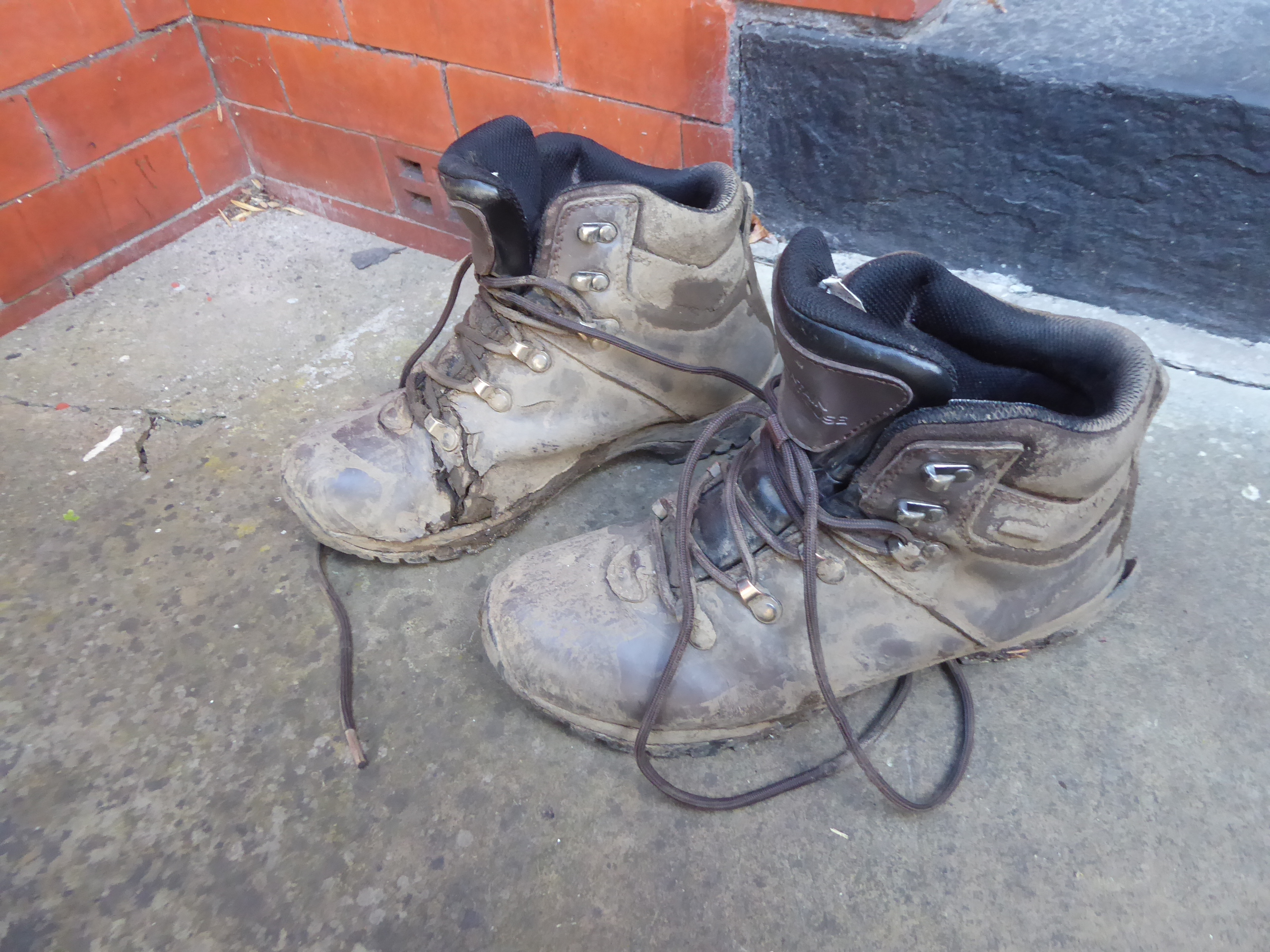
which was once home to the Shuttleworth family, local philanthropist and promoters of education in the mid 19th century, who were acquaintances of Charlotte Bronte, and literally the sole reason for the Bronte Way resolving this far into East Lancs, with our last steps taking us through the neighbouring Home Farm complex, where an NT quality cafe cannot be sustained it seems, where we meet my Sororal Taxi, I guess, having brought Mum at to meet me too for our trip's conclusion, at 4.25pm, indeed one mile over schedule. ~~~ We'll thus ride away, back to Bolton to have our first indoor family get-together since Christmas 2019, pondering along the way the fact of there being still so much of Lancashire to plausibly walk around in the future, while the West Riding has yet to have surrendered all of its paths, noting that even with the many minor digressions made, the Bronte Way managed to travel 5 miles further than expected, and to conclude by shedding Pair of Boots #7 for the last time, done in by muddy conditions and so much wet going underfoot, now far too torn up and leaky to travel another mile.
 |
| Pendle Hill, from Pit Plantation. |
 |
| Gawthorpe Hall, reverse angle. |
~~~
 |
| Shedding Pair of Boots #7 for the last time. |
5,000 Miles Cumulative Total: 4966.8 miles
2021 Total: 224.7 miles
Up Country Total: 4503.8 miles
Solo Total: 4635.2 miles
5,000 in my 40s Total: 3564.6 miles
Next Up: A return to Urban Walking to break in Pair of Boots #8.


No comments:
Post a Comment