15.8 miles, via Nova, Oakwell Hall, Gomersal, Little Gomersal, Rawfolds, Hightown,
Upper House, Sepulchre Hill, Hartshead, Willow Valley Golf Course, Ox Pit, Birkhouse,
Bailiff Bridge, Norwood Green, North Wood, Shelf Hall, Coal Pits Hill, Low House,
Clayton Heights, Sheep Hill, Clayton, Fall Bottom, and Thornton Hall.
 |
Long Distance Trail means Selfies!
#1 at Oakwell Hall. |
Even with the ever changing landscape of this ongoing Covid pandemic, having Spring Jollies away from home in 2021 never quite seemed like a plausible idea, even from the perspective of several months back, but having a break of some kind, attached to long- distance and cross-country trail, accessible from Morley seemed like it would work, allowing us to start out from home and allow My Mum an extended break away from Leicester, while usefully utilizing her as my Parental Taxi service as we made our Trans-Pennine traversal, along the path of the Bronte Way. It's a trail we've had on our radar for a while, along with the route guide on my shelf, but didn't seek to approach as its early going traces a few too many previously seen trails, which is no longer an issue after the last year of regularly retracing steps both locally and further afield, and the fact that the back half isn't really remote enough to warrant a holiday away, but sits at a desperately awkward collection of locations if it were to be traced wholly under my own steam, and issue which our keen planning has already overcome. The name also links it to the lives of the Bronte Sisters, and the wider family, to hopefully illustrate that there was more to their short lives as novelists and writers at the parsonage at Haworth than might be otherwise known, a history which I knew little of until picking up another book, with walks, that placed their personal histories all over the North Country, though I'm not going to start with their actual literature, as that's really not my bag (aside from knowing that Heathcliff and Mr Rochester are garbage fictional heroes, essentially, and that the eminently ridiculous Kate Bush song 'Wuthering Heights' has virtually replaced the original novel in my mental landscape). Enough of my ignorance though, as that's never a good light to stand beneath, there's walking to be done...
 |
| Oh Yeah! I Can Do Literature, I Can... |
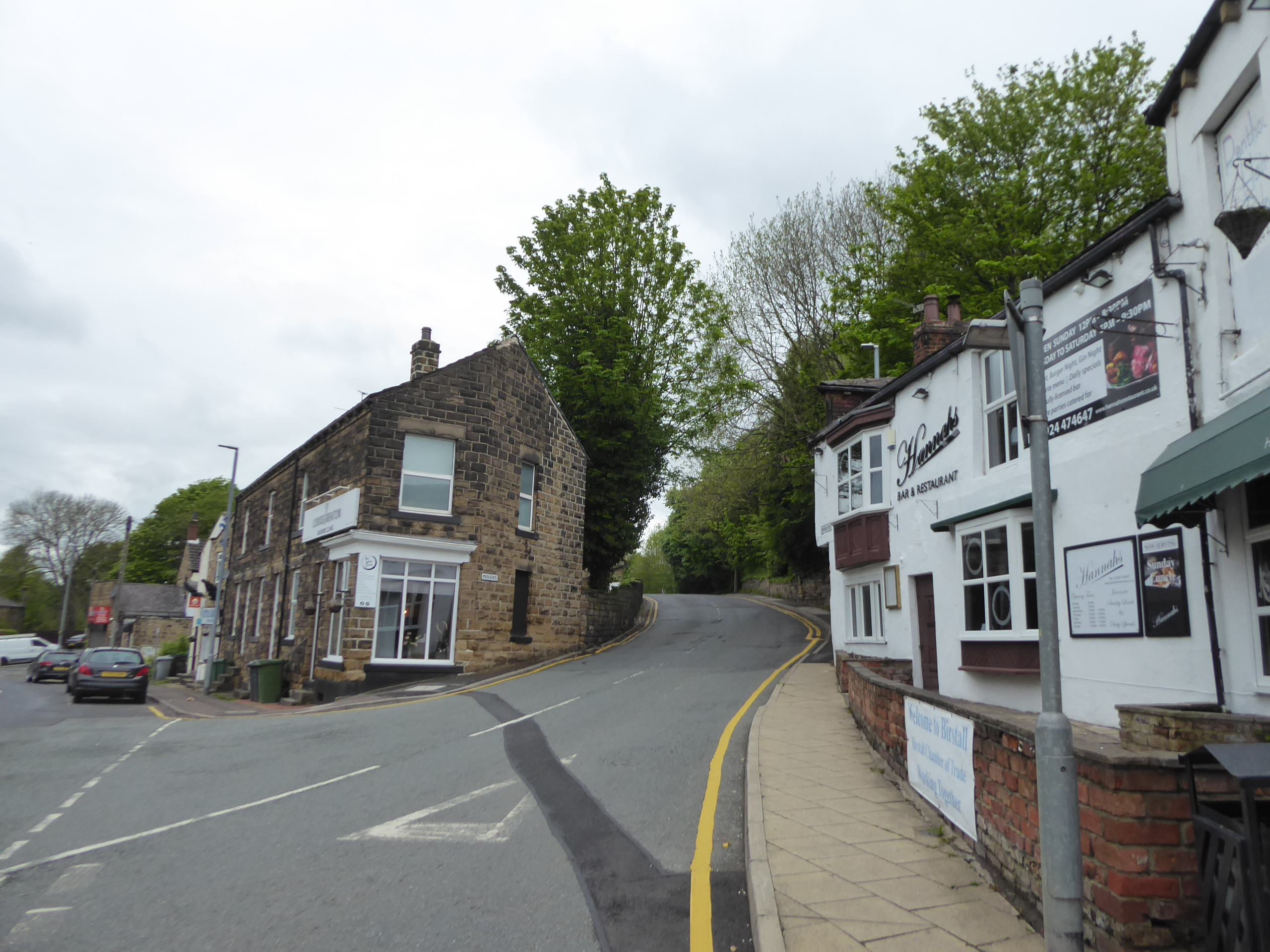
The first leg can be flown solo, and we can hope that Spring actually brings some weather worthy of it as my Ten Day Weekend lands as late in May as it possibly can, as we board the #200 bus to ride out to Birstall, to alight at the Market Place bus stand at 9.25am, and turn our back on its familiar association with Joseph Priestly as we seek the start of our long trail a quarter hour's walk away from town, off Low Lane, up Middlegate and the estate road of King's Drive, and beyond St Pat's RC school and the eponymous hamlet on Nova Lane. We are lead to Oakwell Hall, the model for Fieldhead in Charlotte Bronte's novel 'Shirley', and familiar calling point on so many of our trips, where we can briskly tour around the 17th century house and its walled gardens before we launch ourselves on the trail, from the front door and back down the driveway, and immediately come up with the problem of getting knotted up with the Dewsbury & District Ramblers Centenary Walk, and so we won't be retracing too many recent steps from here to Hartshead, we'll vary the route a bit by taking a hard right onto Nutter Lane. This wanders away from Oakwell House and Nova hamlet, down the southern perimeter of the country park on a very green passage, over Oakwell Beck and around the old site of Gomersal gas works, which is passed around as we emerge onto the A652 and the Dewsbury Road is crossed downwind of the old railway bridge and the field path beyond is joined, giving us the first taste of the muddy going that will be a feature of the day, as we pass below the former railway goods yard plinth, with the close of Summerbridge Crescent atop it, and rise steadily up to the Scott Lane cul-de-sac and the way into Gomersal. I'll have no trouble with retracing steps along the A651 Oxford Road, past the Grove chapel, the old school and the Public Hall as the next feature to note on the way is Red House, home to Charlotte Bronte's school friend and inspiration, Mary Taylor, whose family and residence were fictionalized as the Yorkes of Briarfield in 'Shirley', where we pass around the walled garden and across the neighbouring lawn to meet the ginnel that ran down the side of Gomersal Mills, now home to the housing estate that I've already criticized on these pages.
 |
| Middlegate, Birstall. |
 |
| Oakwell Hall. |
 |
| The Gomersal station goods yard plinth. |
 |
| Red House, Gomersal. |
Land upon the A643 Spen Lane and cross over to enter the yard of the parish church of St Mary the Blessed Virgin, where Mary Taylor's grave is located, passing around the east and south side to join Shirley Road, named after the locally influenced novel, as it passes through the council estate and around its little circus, ahead of passing the playing fields at the far side of Gomersal's hill crest and continuing down to Upper Lane, which is passed over to traverse a way across the angled fields of Sugden Park. This leads to Lower Lane, naturally enough, and Little Gomersal, where the looming house in the middle of the old terrace above, 52 Sisters' Houses, was home to Margaret Wooler, educator of Charlotte Bronte at Roe Head school, who also gave her away on the occasion of her marriage, with the lane beyond taking us past Gomersal House at the corner and the next field path being sought beyond, launching us onto the brow of the Spen Valley, and managing to trace a field route that avoids tangling with the D&DRCW route. Glumness is pervasive over Liversedge and Cleckheaton, but the cloud has little by way of rain to offer, as the field path angles us across to the Mount Pleasnt farm track, which descends us past the Walsh House ruin, over the Leeds New Lines trackbed and down New Street, at the absolute urban limit of Cleckheaton, towards the A638 Bradford Road, where the dual carriageway is traced along to the crossing ahead of Royds Park, where we cross to meet the Rawfolds Mill site, where the Luddite rising of 1812 had its major violent confrontation in April, as featured in 'Shirley'. The path out of the Spen Valley has us trace Primrose Lane beside the Princess Mary athletic stadium, passing over the river, and then rising to pass under the Greenway embankment via the underbridge, one of the few structures on it not examined up close so far, as the day offers more drizzle than it threatened as we wind our way uphill, between the meadows and equestrian fields on the rise up to Hightown, or maybe Middlegate, where we land on the A649 Halifax Road, just uphill from the Shears Inn, the primary meeting place of the Luddites during the the uprising of 1812.
 |
| St mary the Blessed Virgin, Gomersal. |
 |
| 52 Sisters' Houses, Little Gomersal. |
 |
| Rawfolds Mills site, by Bradford Road. |
 |
| The Shears Inn, Hightown. |
Uphill with the main road we then go, shadowing last weeks route by only the width of a few houses and gardens before rocking up at Clough House, for the third time this year, where Pater Familias Rev. Patrick Bronte lived post-1812, after his marriage to Maria Branwell, and where his first two children, the ill- starred Maria and Elizabeth were born, while he served as curate at St Peter's Hartshead, before we slip down Clough Lane again, tracing the D&DRCW route again, and then carrying on down to the passage over Clough Beck, beyond the rural terraces and the ice cream parlour. Enter the fields beyond, to trace the field boundary path up towards Upper House farm, which is muddy and thankfully free of the cattle who's hoof prints we're compelled to walk amongst, eventually landing in the passage behind the yard full of diggers and heavy plant before we pass through its yard, not having any choice but to trace the path previously seen up the long reach of the tree lined driveway to the hamlet of Sepulchre Hill, where Lousy Thorn farm was located, where Rev. Bronte first lodged in 1812, somewhere beyond the roadside to the north. Cross over the B6119 Windy Bank Road, and note our passage over Hartshead Common, scene of the Luddite Ambush of February 1812, before we carry on to St Peter's Harthead, where Rev Bronte served as curate from 1812 to 1815, the role which brought him to the West Riding, and we'll pause here for tea break time, in the yard on its lofty perch over the merging Calder and Colne valleys before leaving the first properly traced circular route from earlier this year, and meeting an older one to carry us west. The Kirklees Way is thus traced again, nearly seven years after the fact as it follows Ladywell Lane and the driveway of Soap House farm over to one of the fine views low-rise views in the county, ahead of the drop down Green Lane, taking us past the gas offlake station and on to the passage over the M62, while departing most of the landscape with it's Bronte associations for a while as we start a long and wandering trail to the northwest, which will aim us over the Calder-Aire ridge, visible on the distant horizon ahead.
 |
| Clough House, Hightown. |
 |
| Sepulchre Hill. |
 |
| St Peter's Hartshead. |
 |
| The Way Northwestwards, from Hartshead Moor. |
We're actually in Calderdale district now as we follow the path previously seen as it leads us into Willow Valley Golf Course, which tidily keeps the golfers and walker separate with hedges and fences, while presenting a few too many options for getting lost among the fairways, tees and greens as paths come and go for use of those who would sport only, testing all the surfaces as the track leads us through mud, rough stone and grassiness on its way through to the A643 Highmoor Lane where the path joins the pavement in search of the next stile onwards. Enter the fields on the lower fringes of Hartshead moor, aiming ourselves beyond the spoil tip left behind by the ancient Ox Pit, and shooing the sheep away as we seek the path over the sole notable remnant of the network of colliery tramways that once littered this hillside, with the path leading beyond the embankment crossing the field to Jay House Lane, and thence departing the Kirklees Way path as we follow Clough Lane up to its eponymous farm, with a field track approximating the lost lane on the way forwards. A first suggestion of a sunshine breakthrough arrives as we land behind the outermost farm of Birkhouse hamlet, where a certain kind of chaos exists in the yards, but a clear route along the dirt track leads us to the hard surface among the old farm buildings and cottages above the edge of the Wyke Beck valley, forming a pleasing little aspect ahead of the descent off the valley side, coming down to touch the Calderdale Way route, with which we are now going to tangle for a while as Birkhouse Road shadows the L&YR Pickle Bridge line, before passing beneath it. That brings us into Bailiff Bridge, following the long terrace that leads down to the A649 Birkby Road, another trunk road to pass over that our trail as already led us across on its early sweep southwestwards, as we also slip over the A641 Bradford Road between the mill sites and the old pub on the corner, retracing the path from 2012 as it cracks on northwesterly along Victoria Road, past the War Memorial gardens and the sea of suburban closes that have replaced the Victoria Mills, on the way out past the upper limit of greater Brighouse.
 |
| Willow Valley Golf Course. |
 |
| Ox Pit, Hartshead Moor. |
 |
| Birkhouse Hamlet. |
 |
| Bailiff Bridge crossroads. |
Field walking follows, along with a passage over Wyke Beck, which appears to be flowing in the wrong direction as we continue on our upstream trend, the first such passage of the way, rising along the muddy field boundaries that are a bit easier to trace when travelling in this direction, going on for much further than would be expected as the A58 Whitehall Road is approached by Nordgreen Nurseries, between the railway bridge with the ghost sign on it, and the towering remains of Wyke Viaduct, where we cross and ponder why we've never walked under either of them. The flowering meadow path and the dirt path beyond lead us to Rookes Bridge, where we pass over the Bradford - Halifax line, below Wyke tunnel and the former Wyke & Norwood Green station site, capturing services travelling in both directions, before following the sticky lane further up to the abandoned cricket field and the tracks that approach Norwood Green from the south, landing by the playground and memorial garden just as the sun makes another breakthrough, allowing for a brief bask during another watering stop. It's glum again once we join the Village Street, passing north among the pleasing array of terraces, greens and cottages, and being a bit more eager to take in my surrounding this time as we rock up past the Old White Beare inn, the former St George's church and the congregational chapel, with the clock tower being found at the top, seeming rather over-scaled for the size of the village until you note that is was once the feature of the village school, now proudly greeting anyone entering via the Calderdale Way route, which we are still firmly in the mix up with. Outbound on the farm lane we pass Lower Ox Heys farm, former, and on to meet Middle Ox Heys, also former, before the field paths resume again, offering no indication of the uppermost Ox Heys farm, as we trace the edge of North Wood, which itself conceals the downstream passage of Coley Beck, at the remove of a field or two, before the sidle downhill comes to enter the woodland, just as the day starts to properly tussle with idea of turning pleasant, so naturally we need to have shade in this particular moment.
 |
| Wyke Viaduct. |
 |
| Trains at the Wyke & Norwood Green station site. |
 |
| Norwood Green Clock Tower. |
 |
| The descent to North Wood. |
The rough, and muddy path above Wood Fall Beck brings its own sort of challenges, but things get sketchy as we approach the hairpin turn that leads to the steps beyond Wood Cottages, where a water runoff has gouged a groove in the path a good 18 inches deep, which seems unsafe to try to walk in or above, so it's fortunate that there is another stream crossing a short way back to use instead, negotiated via rocky sort of scramble down, and leading up a steeply stepped path up the meadow below Dean House farm, which is passed around to get on a safer surface. The long driveway road, which I'd like to think all claims the name of Bridle Stile, leads a way among the fields of sheep that sit atop the ridge between the wooded depressions of Sun Wood and Wood Fall, leading into that urban space that seems to sit separately between the bulk of Shelf Village to the northeast, and Stone Chair to the southwest, which seems considerable in itself, and we'll call Shelf Hall after the parkland that sits opposite the long terrace on the A6036 Halifax Road, where we'll make our last acquaintance with the Calderdale Way, via the ginnel up to Shelf Hall Road. The Way suggests the way forwards is via Broad Ings farm but before we've even entered their grounds a local man stops me to pass on the warning that the yard and track beyond is a sea of deep mud and irritable cows, and instead offers the alternative route uphill via the new-ish housing development in the adjacent plots, with Broad Ings Way and Parkstone Rise offering a more secure passage up the field paths above, which is gladly taken after some of the tough going we've already had today. We've risen ourselves to high field altitude up here without really noticing, coming up closer to the Calder-Aire ridge ahead, and gaining an evolving view south as we rise to almost 290m up, revealing the Holme Moss horizon, and the Colne - Calder ridge ahead of it in a previously unseen sequence, while I have to pause to process the fact that the middle ground has Wyke and Hartshead Moor illuminated in it, proving again that there's plenty of fresh perspectives to see in West Yorkshire, if you keep seeking new paths.
 |
| The alternate passage over Wood Fall Beck. |
 |
| The long walk up Bridle Stile to Shelf Hall. |
 |
| The alternate path through Shelf Hall. |
 |
| The Southern Horizon rearranged. |
Beyond our immediate field paths, Foster Park and Queensbury advertise their proximity, though we aren't going much nearer to them as our tracks lead to Bridge Lane, which angles us closer to the upper edge of Shelf, and our previous passage in this quarter in 2017 on South Lane, which I don't recall as having been nearly as revealing as today, and the ancient spoil heap remnants of Coalpits Hill don't sit in my memory either as we follow Brackens Lane around their northern edge, and on to the driveway to the lost Upper Bracken Beds farm. Field walking follows, taking us down to the rather sketchy passage over Blackshaw Beck, and rising us up to the grounds of Bobby Green farm, before we meet the paths that slip through the squeeze stiles among the many dry stone walls that separate these small fields beyond the very western edge of Bradford, the proximity of which is very well concealed beyond Low House, hidden behind a bank of trees that contain the approach drive and Stocks Lane, which leads us up to the primary school, the Clayton Heights Methodist chapel and Asa Briggs park, on the edge of the A647. Cross over here, and breach the Aire watershed as we do so, joining Sheep Hill Lane as it roughly traces the outermost reach of suburban Bradford, where the back gardens of Clayton Heights sit on the high edge and enjoy a local view over the rolling valleys down towards Clayton and Thornton, back up to Queensbury and on to the bulk of Rombalds Moor, as well as across to the Southern Dales horizon that hasn't been seen in years, a reveal to warm the wanderer's heart before we are forced steeply downhill, across Back Lane and down the field boundary paths on Sheep Hill. Bradford is revealed to the west before we are dropped us onto Baldwin Road, which takes us over the passage of narrow fields that contain Clayton Tunnel, before we enter Clayton itself, through very briefly as all we see of it are the Rowantrees retirement apartments and the Brook Lane hairpin corner before we are out of it again, following another edge path around the back gardens, on to another reveal across the meadows to Thornton, one valley crossing away from here.
 |
| Coalpits Hill. |
 |
| Field Walking to Low House. |
 |
| The near and far horizons revealed, Clayton Heights. |
 |
| The Brook Lane hairpin, Clayton. |
Downhill we head, among the frankly crazy amount of wrinkles that the landscape provides, and getting somewhat anxious when presented with squeeze stiles that feel like their walls could topple onto the walker without much provocation, finding a new suburban edge growing out from Clayton further down and tracing a route betwixt fence and wall which the local horses regard as no obstacle to having a conversation across, all the way getting the evolving view over to Thornton viaduct in the west, illuminated from the wrong side again, as it seems to have been on every visit. Bottom out the descent below the rough fields, meeting the muddy track by Hole Bottom Beck, and land on Low Lane, which is followed up to the triangular road junction and farm cluster at Fall Bottom, squeezed in between the merging becks at the valley floor, where Corn Mill Lane leads us around to the passage over Pinch Beck, on its way to the Thornton Mill site, ahead of the field climb at the end of today's leg, to be made just as the day finally makes a sunny and warm breakthrough, which is definitely better late than never. Land on the lane that leads up to Thornton Hall, the old manor of this parish, just at the point where the suburban houses retreat from the south side of Thornton Road, which we meet the side of as we pass below the looming late Victorian parish church of St James, rising above the cemetery where the ruined remains of the older Thornton Bell Chapel lie, where Rev. Patrick Bronte was curate from 1815 to 1820, finally reviving the historical links on The Way that you'd thought we'd forgotten about, but which Thornton hasn't, as we rise to meet the Bronte Old Road above the main drag. This leads through the council estate and on to the old Market Street, with its runs of picturesque terraces, cobbled side streets and enduring vintage feel, which in the middle of we can find the Bronte family birthplace, where Charlotte, Branwell, Emily and Anne were born during the Rev. Patrick and Maria Bronte's five year residency, the place where the story really starts and our day ends, a little later than planned but under sunnier conditions than expected, and so the joys of Spring Jollies have really taken hold, as we drop down Ball Lane to the nearby bus stand, wrapping at 4pm, mere minutes ahead of the #67 bus running us back homeward bound.
 |
| The view to Thornton, from Clayton. |
 |
| The view to the Parish Church, from Fall Bottom. |
 |
| The Bell Chapel, St James's graveyard. |
 |
| The Bronte House, Market Street. |
To Be Continued...
5,000 Miles Cumulative Total: 4935 miles
2021 Total: 192.9 miles
Up Country Total: 4472 miles
Solo Total: 4603.4 miles
5,000 in my 40s Total: 3532.8 miles
Next Up: Across the Heart of Bronte Country and Over the Top to Lancashire!


No comments:
Post a Comment