Burnley Manchester Road to Burnley Central: 1.2 miles, via Centenary Way and St Peter's.
It feels like we've been waiting for the entirety of Summer for Summer to arrive, and now it actually feel like it's arrived, it's already done, as are my Jollies, thus starting out from Morley again as we return to the long trips on the train, looking to complete this three legged excursion around the western edge of the expanded field of experience in the East Lancs valley, heading out with my left foot's sole stuck together with one off-brand Compeed plaster and knowing that even with a 7am start from home, it's going to be a three hour trip to the starting line. As is familiar by now, the connection options in Burnley are awful, and thus to make best use of a wasted hour, it's best to alight at Manchester Road station and walk across the town again, alighting at 8.50am to find that the way up to the A682 is indeed a challenge, rising up the long allegedly level access ramp which adds minutes to any westbound connection, before we set a course around the east end of the town, hitting Centenary Way beyond the traffic island to head over the flyover that we passed under last time out, looking west to the town and its Town Hall, framed by Pendle Hill as we also pass over the canal. Looking east, the best, and indeed only, views to Boulsworth Hill and the Hameldon Ridge can be had over the roofs of Tesco and the bowling alley, ahead of the descent down to pass behind the police station and courts complex, before we come up to the eastern end of St James's Street, in the shadow of The Culvert and its embankment, and carry on up Church Street, passing below the high rising St Peter's Centre, the only tall building in the entire town, located in a loop of the River Brun, across the way from the closest batch of enduring terraces and townhouses in the town, around the bottom of Ormerod Street. Past the oldest schools in the town, we meet Burnley's parish church, St Peter's, located in it's yard in another twist of the Brun, and looking to celebrate 900 years of its recorded establishment in 2022, giving some ancient history to a town that doesn't suggest much before the 19th century, passed around as we join School Lane, passing below the old Grammar School on the way up to Active Way, which is crossed as we seek the alternate path to Burnley Central station, between the Anchor and Prestige retail parks which hasn't been cut off due to the dereliction of the Adelphi hotel, landing at 9.20am, meaning the last train trip of the morning will only require a half hour wait, and then we can lead you into the day's scheduled programming...
 |
| Burnley from the Centenary Way flyover. |
 |
| High Rise Burnley from Church Street. |
 |
| St Peter's parish church, Burnley. |
 |
| The derelict Adelphi hotel, Burnley Central. |
~~~
13.7 miles. via Colne Field, Christ Church, Laneshaw Bridge, Emmott Hall, Wycoller Country
Park & The Atom, Combe Hill Scar, Cross Bent, Water Sheddles Reservoir, Moor End,
Ponden Reservoir, Scar Top, Oldfield, Pickles Hill, Denby Hill, Lane End, Oakworth, Lidget,
Sykes Head, Bogthorn, Exley Head, and Holy Croft.
We finally get our train ride that allows us to properly use Colne station, arriving at 10.05am after the longest trip out from home that we've had in along while, and thus we need to get a move on to get us back to West Yorkshire as we descend to the A56 Albert Road, starting our eastbound trajectory as we pass uphill, by the Leisure centre and the Crown Inn to find a surprisingly old town reaching up its hillside, actually presenting itself as one of the great hidden High Streets in this land as we rise up to the War Memorial, the Muni(cipal) theatre and the cupola-ed shopping arcade opposite the Post Office. It's all very presentable up here, like I wasn't sure what to expect, and at the hilltop, we have the Town Hall at the peak, with the Methodist chapel and old Parish Church of St Bartholomew flanking it, before we crest over on to the main shopping drag of Church Street and Market Street, still wearing a lot of late Georgian vintage in its frontages, around the later developments of the town library and indoor market, ensuring that it's by no means the forgotten town at the head of the East Lancs valley, indeed it might be the most pleasant of them all, all looking busy and bustling in the morning sunshine. It will probably be a hub for future walking too, as illustrated by having the Skipton Road split off at the eastern end of town, and we'll press on with the Keighley Road as it presses into the landscape of smarter terraces, with the side streets giving us not just a view over the deepening valley of Colne Water and on to the high apron of fields beyond, but also the first appearance of the western face of the Pennines, seen from this side for the first time since Burnley, especially notable with the view across the plots of Colne cemetery, ahead of meeting the local cricket field again at Colne Fields. Meet the traffic island at the top of the Trawden road and the end of the bypass, and gain the A6068 as Keighley Road sets us off into the suburban ribbon beyond the main town, taking as outside of the field of walking experience as we set to move its northwestern boundary further taking us into leafy and heavily hedged suburbia as the town seems to gradually peter out ahead of us meeting Christ Church, the contemporary parish church to the town, apparently, on its perch above the road and adjacent to its school, right at its eastern extent.
 |
| Finally getting some Train Action at Colne station. |
 |
| Albert Road, Colne. |
 |
| Market Street, Colne. |
 |
| Keighley Road, Colne Fields. |
 |
| Christ Church, Colne. |
Our perch above the valley is obscured as we press east still, as dense tree cover takes over this side of the lane, as we press on into the countryside, getting a flavour of farmsteads and rural terraces about as we pass Crow Nest and Spring Row, before the suburban landscape resumes, with the Hartley Homes courtyard (named for Wallace Hartley, the bandleader on the RMS Titanic and an enduring local hero it seems) and the most ostentatious of outsizes houses arriving ahead of a ribbon along the lane, elevated to make the best uses of the view to the Pennines across the way. It's an aspect we regain as we make the shift into Laneshaw Bridge, the last settlement of note on this stretch of the East Lancs Valley, cluster around the former chapel and the Emmott Arms before the road strikes itself off onto the moorlands and into Airedale to the north, where the Burnley trams used to have their exceptionally remote terminus and we'll make our turn from the blocks of rustic terraces to make our descent to cross over Colne Water, passing the Rye Flatt B'n'B (the most conveniently located one for a solo trek on the Bronte Way) and then rise with School Lane as it takes us towards West Yorkshire. This sharply rising lane, taking us up between the Boulsworth Hill and Keighley Moor uplands, is definitely one that I felt wary about, as it has more traffic than any unclassified road ought to have, surely brought here by the wisdom of sat-nav, and its sketchy going up to the grounds of Emmott Hall and its farmsteads, before we get an improved sight line beyond, giving us plenty of warning as the traffic descends around Far Laithe farm, with its fields of herding alpacas and we gain the fine views ahead, looking over the Wycoller Beck valley and up to the Pennine ridge. It's steep going for much of the way, but the challenges come with the rewards of the expanding views of the flanking hills on the east side of the Colne - Pendle valley, taking the eye to Castercliffe and Walton's Monument before Pendle Hill rises onto the reverse horizon, along with the unknown hills to its north that we'll probably get to in 2026, as we cross over the Pennine Bridleway route as it wanders off in the vague direction of Settle, and then get the full heat of the sun in our faces as we press uphill further.
 |
| Hartley Homes almshouses. |
 |
| Laneshaw Bridge. |
 |
| Emmott Hall. |
 |
| Wycoller Back valley, and the rising Boulsworth Hill. |
 |
| Walton's Monument, and Pendle Hill. |
This leads us up to High Laith farm at the next kink in the lane, and the presence of stone walls made of roughly hewn vertical slabs, must surely put us in the vicinity of Wycoller Country Park, which is indeed located beyond the corner, and though we've no reason at all to make another visit to it, we'll cross the roadside par park to visit The Atom once more, as it offers a place for elevenses at almost lunchtime, where we can review what we've learned about this East Lancashire landscape since our first encounter with it back in May. After all the travelling it took to get here, we can still feel close to home again, as we resume our eastbound passage, hitting the steepest reach of School Lane, where there's barely enough psace for the passing traffic, let alone any additional walkers, and thus it's careful steps as we press on, gaining the 50m of altitude that puts us onto high moor altitude, and tagging the sights on the southern horizon whenever its safe to do so, looking over the grassy bank to the five point of interest atop Boulsworth Hill or back into the valley behind us. Rise to meet the Herders Inn, or the Oldham Arms, depending on your map vintage, the travellers pub which no longer does business on this lane, but now sits as a dramatically situated house on its perch, over the valley of Smithy Clough where the view over the ruggled and heavily mined floor can be observed, as can something on the northern horizon at long last as Combe Hill rises ahead, with its heather-clad flank dropping down to the roadside, upon which men wave large flags, which I believe indicates that there's grouse shooting going on up there. There's no sound of that frankly unnecessary business going on as we settle in with the lane below the rocky edge of Combe Hill Scar, passing the couple of Combe Hill Cross farmsteads that cling to this high valley side, both with views that are superlative, across to the sharpening angle on the western face of Boulsworth Hill and back down to Colne, still peeking above its own valley as Pendle Hill rises beyond it, while ahead we can look up to Crow Hill as it rises on the eastern horizon, offering its most pronounced shape when viewed from this angle, though sadly sitting beyond the scope of this year thanks to all those days lost to rain.
 |
| The Atom, again. |
 |
| Boulsworth Hill. |
 |
| Smithy Clough. |
 |
| Combe Hill Edge. |
Around the nab corner of the hillside, below Combe Hill Cross, we get the transitional watershed moor opening out ahead of us, revealing much more on our northern horizon, leading the eye across to the outcrop of the Wolfstones as we pass the corner of the track leading into Smithy Clough, and set a course with Two Laws Lane across the moorland of Cross Bent, shadowing the route of the Bronte Way much more closely now as we track on among the undulations that frequently unsight us to the oncoming traffic, despite the relatively level going. The English Watershed the approaches, beyond the worst dip in the road, with the lump of Barn Hill (or Wycoller Ark) obscuring the view into the Worth Valley until we've almost passed the Peat House access track, by which time we have Water Sheddles reservoir on our immediate horizon, filling out the headwaters of the River Worth and drawing us ridiculously close to our prior trek over here westbound, thus extending the border of out field of walking experience by little more than a few metres to the north of the perimeter wall, as the traffic does its best to rip it up over the summit plateau. The rise of the lane before the dam gives us our last close view back to East Lancashire, not to be seen up close again until the paths to the east and south of West Yorkshire have been given a good pacing in future seasons, and we thus drop below the embankment to meet the border markers, which is crossed in a rare west-east passage ahead of the drop of the lane commencing, with agriculturally manicured field returning to the roadside as we meet Moor End, where signs indicate a pop up pub has been established at Two Laws farm That could inspire interest if we didn't still have quite a distance to travel, a realization that sets in as we come in by Moor Lodge farm, across the lane from the Moor Lodge Country Retreat, which appears to still be not doing most of its business thanks to Covid, as we meet the end of Cragg Bottom Road and we are given the indication that we are only half way on our trip, as the division of the lane gives us a trio of potential route to pursue, and we'd already planned to take the middle one of them, which demands a tilt downhill with New Laithe Road.
 |
| Wolf Stones and the northwestern moors. |
 |
| Crow Hill. |
 |
| Water Sheddles Reservoir. |
 |
| The Uppermost Worth Valley. |
 |
| Ponden Reservoir and the greater Worth Valley. |
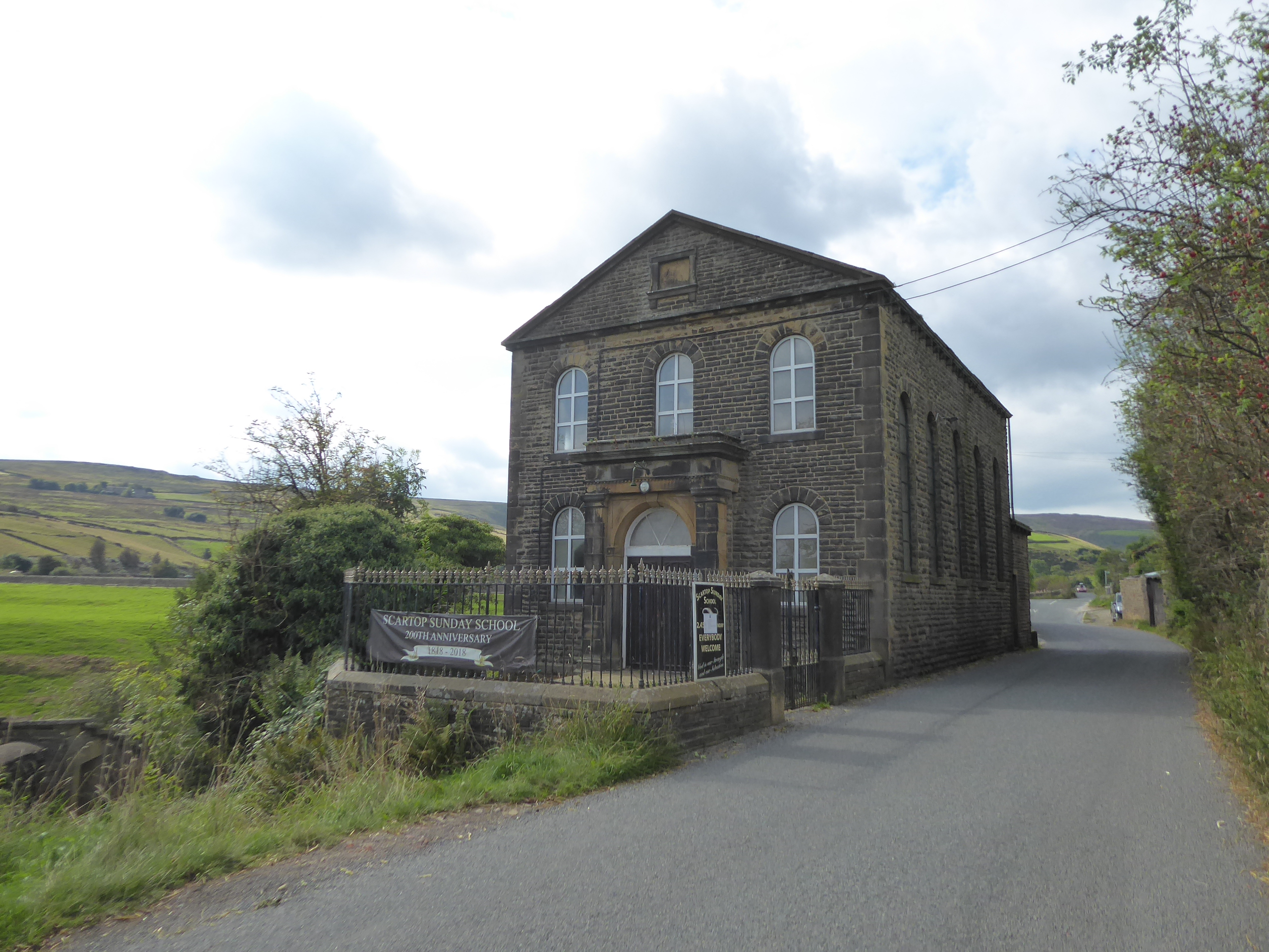
With Ponden Reservoir as our target ahead, we drop down past the lane's eponymous farm, looking across the valley to spy the Bronte Way route that wandered among the farmstead s and cottages on the far bank before descending into the the deep clough on the upstream passage, and while the traffic has thankfully eased, the sight lines we have among the hedge, walls and descending kinks are much less friendly, as we drop down to find ourselves rather suddenly at the valley floor as the River Worth arrives by the riverside almost unannounced. We also find ourselves below the gouge of Dean Clough as it descends from the north side of the valley, and that means we are due to seal the new border of the field of walking experience for 2021 as we meet the Pennine Way coming up the lane from the bridge over the river at the end of Ponden Reservoir, thus encompassing most of the bulk of the moorland on the northwestern edge of West Yorkshire, before we set in to the shoreline walk, which is as undulating as they come despite being on road surface as we rise to the worst blind summit on the whole trip. Looking uphill, there's definitely a bunch of farms on the north bank that are all located on the spring line on the hillside, while across the reservoir we can spy the back of Ponden Hall, on the finger of land between the two distinct upper branches of the reservoir, ahead of us meeting the hamlet of Scar Top, sitting on the shore to the north side of the dam, which seems to have its own flock of tame ducks to go with the scenic views as standard, while its most prominent feature is the Sunday School, to be found to the east and showing its history as an establishment of over 200 years standing. The next road division sits a little way ahead, where we need to turn uphill so we don't continue on towards Stanbury and Haworth, and its worth noting that down there somewhere is Ponden Mill, where the home goods store chain was initially established in 1974, not to be seen as we rise up Oldfield Lane, regaining some of the height lost as we took in the reservoir on our path, getting a view over the dam and up Ponden Clough before rising up to New House farm and finding a shaded bench where we might pause to take in a late lunch and watering break, which feels much needed after all the heat and sunshine of the early going.
 |
| Ponden Reservoir. |
 |
| Ponden Dam. |
 |
| Scar Top Sunday School. |
 |
| Ponden Dam & Clough. |
While stopped, we get stalked by some kind of blue shrieking creature, which turns out to be a loose Peacock, and once ready to get going again, the warmth of the day seems to have passed, as the cloud dynamic starts to block out the benefits of the sunshine, proof that the end of summer is now upon us as we resume the rise of the lane, looking back over the ridge of the hillside that rises between the Worth and Sladen Beck, beyond which the Aire-Calder watershed ridge starts its gradual rise, to be taken in as we pass above the chaos that has overtaken the fields around Intake Laithe farm. Oldfield is the next hamlet of note on our passage, last seen when the Bradford Millennium Way brought us up the hill, and we probably pondered then how most of its farmsteads sit below the lane, again ranked along the spring line I'd assume, and we certainly wondered in 2013 how such a tiny settlement of a few farms and a couple of terraces could sustain a school, especially when you consider that there's really not much of any habitation along much on the Worth Valley's western reach to provide it with even a modest catchment area. Penistone Hill rises to the south of us as we trace a gradual northeasterly route, providing enough bulk at the heart of the greater Worth Valley to obscure most of the branch and horizon to the south of Haworth, and thus the attention wanders to the southwestern horizon as we sit above West House farm, tagging Top Withens at its exposed altitude in the far distance, before we take a closer interest in things closer to, like the cock pheasant darting around in neighbouring field or the next farm along our lane, Laverock Hall, which shows up its 17th century vintage rather proudly. There's a high lane to get back to as Oldfield Lane come up to its end, turning its way uphill around the fields of Near Scholes farm to land on the route we abandoned a few miles back, arriving by the Pickles Hill terrace and its Sunday school (no longer enduring in business here), just as the day gives us one last blast of warmth and sunshine, and the turn of the lane takes us towards the Hob Cote farmsteads, giving us a last look to Haworth, sitting above the junction of the merging valleys, before we crest over the hillside and our attention is drawn downstream.
 |
| Ascending Oldfield Lane. |
 |
| Oldfield School. |
 |
| Penistone Hill. |
 |
| Pickles Hill. |
Rombalds Moor rising on the horizon above Airedale and Keighley can finally make it feel like we're close to to day's end, but there's a lot of urban landscape to pass through before we can consider this day done, as Oakworth appear before the road hits its decline and signage greets us into it before we've even got out of the fields around the Hob Cotes, ahead of the downhill drop between high walls before we arrive at the southern edge of the village among the suburban spread of Denby Hill, where the rural terraces and suburban arrivals butt up against each other chaotically. Join the B6143, finally giving an identity to the route that we'll walk to its conclusion, falling and rising among terraces which seem designed for the purposes of domestic weaving before we come around by the later developments around the Golden Fleece inn, before Colne Road leads us on towards the Snooty Fox inn, located in the old church school, and the pile of Christ Church itself, where we previously came this way in 2013, ahead of our drop down to the Chapel Lane corner with the cottage with the extremely lengthy inscribed tablet on its wall. There's certainly a lot more to Oakworth than just being a stop on the K&WVR, famously used in the 1970 film of The Railway Children, the turn to which can be found after we've passed the village Social Club, and Holden Park, which suggests a fashion rather more stylized than your average park, which makes sense when you discover that it occupies the ground of Oakworth House, after which we rise again, past the Methodist church and the main parade of shops, and among more long runs of blackened terraces. A sign tells us that it's 2 mile to Keighley from here, and as we elevate enough to get to a break in the terraces, we can look across the open fields and over to the far side of the valley, revealing that we're level with Cross Roads with Lees, which feels about right, and it's hard to tell if we've passed out of Oakworth here, or moved into greater Keighley as the local borough signs bring rapid location changes between areas that you'd never previously heard of, as we transition between Lidget and Sykes Head, while considering the boundary to be located beyond the quadrangle of Charles Edward Sudgden's almshouses.
 |
| Oakworth from Denby Hill. |
 |
| Colne Road, Oakworth. |
 |
| Holden Park, Oakworth. |
 |
| Looking to Haworth and Cross Roads with Lees. |
Bogthorn is the next district met, which is terraced down one side of the Keighley Road, with suburban infilling rising up the hillside on the eastern side, with the Valley View Court care home being a particularly large development, while a little further down the hill the suburban arrivals of the middle 20th century have claimed all the views elevated above the west side of the road, with the council estates below, ahead of the Branshaw Park development claiming another open field, above Occupation Lane, where another 2013 trail brought us. That means we're going to be matching footfalls for most of the way into Keighley, around the grounds of Beckfoot Oakbank school, and the fields of the old house that named it, before passing through the next old hamlet, Exley Head, before we hit the definitive and final dive downhill into the town, with the Oakworth Road leading us into the landscape of grey council houses and dull coloured stone houses that leads us to the terraces that angle away from the road around Lund Park, which we didn't see on our previous trip this way, ahead of the district of Holy Cross. Beyond the short shopping parade, we meet Hillworth Village, which looks like an almshouse complex but was actually the Keighley Union Workhouse, surely one of the most picturesque establishments of its kind, located uphill from the Springfield Mills complex, itself across from the Oaks Centre and up from the parking chaos of Royal Mail vans around the Keighley delivery office, all of which sit ahead of our landing on High Street, rather suddenly arriving in town after taking so long to get here, where we make our passage around the traffic island and cross over the A629. Pass the green around St Andrew's parish church and head on along Low Street, which seems a bit light on shops and shoppers, probably drawn to the Airedale centre to the north, before we meet the head of Worth Way and the hidden gem of the Royal Arcade, ahead of the bars and eateries on East Parade, where a pint of Timothy Taylor's Boltmaker would definitely appeal as the day wanes, but it's got to be a dash to the finish line from here, past Iceland and Aldi to rock up at Keighley station at 4.05pm.
 |
| Bogthorn. |
 |
| Exley Head. |
 |
| Oakworth Road, Keighley. |
 |
| Low Street, Keighley |
Postscript: That is indeed that for all my interactions with the East Lancs valley for the time being, so near and yet so strangely far away, and after all the shenanigans we've had with travel back on all three of the railway lines we've had to use to get back to Morley, it's a most welcome experience to land midway up Airedale in exactly the right window to board the Leeds-bound express from the Settle & Carlisle line, as that give me a boarding to home trip on only one hour total, an insane contrast to the regular 3+ hours rides we've had before.
PPS: No foot pain of any kind was experienced at any point during the trip, with my off-brand Compeed plaster doing in excess of what was as asked of it, which makes Wednesday's episode of blistering, my first such in three years, all the more baffling, which has me wondering of something as simple a wearing a new pair of socks could have shredded my Sole?
5,000 Miles Cumulative Total: 5181.6 miles
2021 Total: 439.5 miles
Up Country Total: 4718.6 miles
Solo Total: 4850 miles
5,000 in my 40s Total: 3779.4 miles
Next Up: Getting Back into the Calder - Aire High Moors.


No comments:
Post a Comment