11.7 miles, via Hopton Bottom, Briery Bank, Whitley Wood, Whitley Lower, Briestfield,
Dimpledale, Thornhill Edge, Edge End, Rectory Park, Mill Bank, C&H Navigation,
Healey Mills, Pildacre Fields, D&O Greenway, Earlsheaton Common, and Sands Lane.
 |
Long Distance Trail
means Selfies!
#3 at Mirfield Station. |
I'd have loved to have gotten this whole trail down within the Easter weekend, and a different vintage of myself would have eagerly been out there on the Monday, but my contemporary vintage is starting to feel the need to not push things so hard, and thus time is taken out to do other necessary things and the D&DRCW has to wait its turn in the schedule, dropping in on the last quiet weekend before the National Lockdown restrictions see their next significant easing, and also ahead of myself getting my second dose of the Covid vaccine to hopefully ease my mind ahead of the renewal of the crowds. We also have a nice day promised by the forecasts as we ride back out to Mirfield for a jump off ahead of 9.15am, rejoining the circuit path below the deep Station Road overbridge, heading south on Hopton New Road between the open fields and the large plots of allotments to approach the crossing of the Calder at Hopton Bridge, all the way feeling that the dense bank of cloud lingering to the south of the river was not something projected to happen today, before our path takes us a little way east along Granny Lane before slipping onto a path that takes us along between the back gardens, both old and new, of the suburban enclave of Hopton Bottom. Enter the fields as the path skirts the looming woodlands of Briery Bank, tracing the boundary before heading across to Valance Beck, which is crossed before we hit the sharp rise beyond, seeing naught but gloom ahead of us the the southwest, with the blue skies receding to the north as we look back over New Hall farm and woods to Mirfield and greater Dewsbury, and expanding the horizon northwards before we crest and field walk downhill again. A track is joined, skirting around Royds House farm in its own little glade, as we are lead downwards to pass over Liley Clough and then rise among more foliage free trees, to meet the track up from Hopton Mills, passing below Brier Knowl farm perched above, a lane which we traced southwesterly a good few seasons back, and those steps are retraced down towards the cottage cluster at Whitley Wood Bottom, whilst we aim a new track southeastwards, on one of those rare trajectories that has been distinctly absent on all our previous local travels.
 |
| Hopton New Road allotments, Mirfield. |
 |
| The view over Mirfield from Brier Bank. |
 |
| The pathway through Liley Clough. |
We enter Whitley Wood on a steep and unrelenting track, one of those prime ones for the local exercisers and their dogs, heading up beneath the canopy of bare trees, still not leafing up as Spring remains cold at the point in April where warmth usually starts to win out, and the path quality varies wildly as we ascend away from the immediate influence of the Calder, with the dirt track regularly getting sticky as it traces the wooded clough uphill, and only gaining a stone surface above the ruined and secluded remains of Calf Croft farm. Land on Mousehole Road at the top, with gloom claiming the southern horizon totally as we are lead in towards Whitley Lower, tracing Scopsley Lane as it traces a path between the block of council houses and the reservoir chamber at the hill crest, landing us on Whitley Road by the Woolpack Inn, where great care has been made to create a decently socially distanced beer garden, and we cross here to Howroyd Lane to lead us over to the church of St Mary & St Michael, a proudly Romanesque pile accompanied by the bucolic aromas of its neighbouring farm. Drop down beyond, past the Vicarage and the village hall in the old school building, before slipping over a rather odd metal stile to join the path downhill into the next clough along, on a firm surface of concrete and flagstones for much of the descent, which actually does little for the slickness of the mulch that has accumulated upon it as we drop down to pass over Howroyd Beck, and then rise again, sharply on more flags, which ensures this isn't going to be a speedy sort of day, to land us on Back Lane on Briestfield's hillside. The walk route is deviated here, to stay on the road as it gives us a look over towards Thornhill on its own hill to the northeast, rather than looking over the rather anonymous patch of rural land to the south, bounded by Grange Moor and Overton, while the brighter weather seems to be found only in Wakefield district to the east, before the precipitation starts as we pass around Back Lane farm and land in the village, and against all expectations, it's actually snowing, or sleeting at the very least, and thus our early tea break in the memorial garden is accompanied by a persistent shower of ice flakes.
 |
| The ascending path through Whitley Woods. |
 |
| St Michael & St Mary, Whitley Lower. |
 |
| Howroyd Beck, between Whitley and Briestfield. |
 |
| Thornhill and its Edge, from Back Lane. |
10 minutes of that is enough to experience whilst sitting still, and it continues as we resume on the trail, joining Briestfield Lane as it passes around the Shoulder of Mutton inn, and despite my reflection on the growth of this hamlet when I last came this way, it doesn't appear to gave gained any more smart houses at a remove from anywhere in particular before we head out on one of the walk's eccentric detours dropping us down the valley side to the south into Dimpledale, where a local man exercises is energetic dog and laments to us the apparent failure of Spring to arrive on schedule. Heading downhill at least get us out of the breeze, meeting Upper Dimpledale house and Sowood Lane briefly before joining the driveway to Lower Dimpledale, feeling like you're having a good trespass before spying the way marker that leads between the buildings and uphill on a path that would surely be horribly overgrown during the green seasons, landing us on a field path slightly above this secluded valley, tracing us eastbound on some awkwardly angled slopes, on a footing that's firm enough to allow us a hurry through our first field of idle bovines met on our travels this year. Pass below the plots of Carr farm, with its many fences and stiles, and tangle up with the Kirklees Way route again as we rise up to Carr Lane at the crest of the hill, and start a long retrace of 2014's steps again as we descend down the far side, finding the that the route down to Howroyd Beck is complicated by the fact that path at the tree line which we are following at the field boundary cannot be consistently traced as a recently installed fence has us switching sides on multiple occasions due to overgrowth and lack of space before we bottom out at the stream crossing. The fun of a sharp elevation awaits again as the path rises us up towards Low Lane, noting the field of Alpacas in the field below before we set on our way up through the suburban spread of Thornhill which has grown to appreciate the southwards aspect, meeting the long and sharp drag up the dirt groove of a path to High Street which is now fun at all with some slickness being added to the climb up between the suburban gardens, and it's not even a climb that's done when the top road is met, as another steep flight of steps has to be pounded up to meet the western end of the Thornhill Edge path.
 |
| The Shoulder of Mutton, Briestfield. |
 |
| Dimpledale. |
 |
| Thornhill Edge from the vague path. |
 |
| The hirrible path up to Thornhill Edge. |
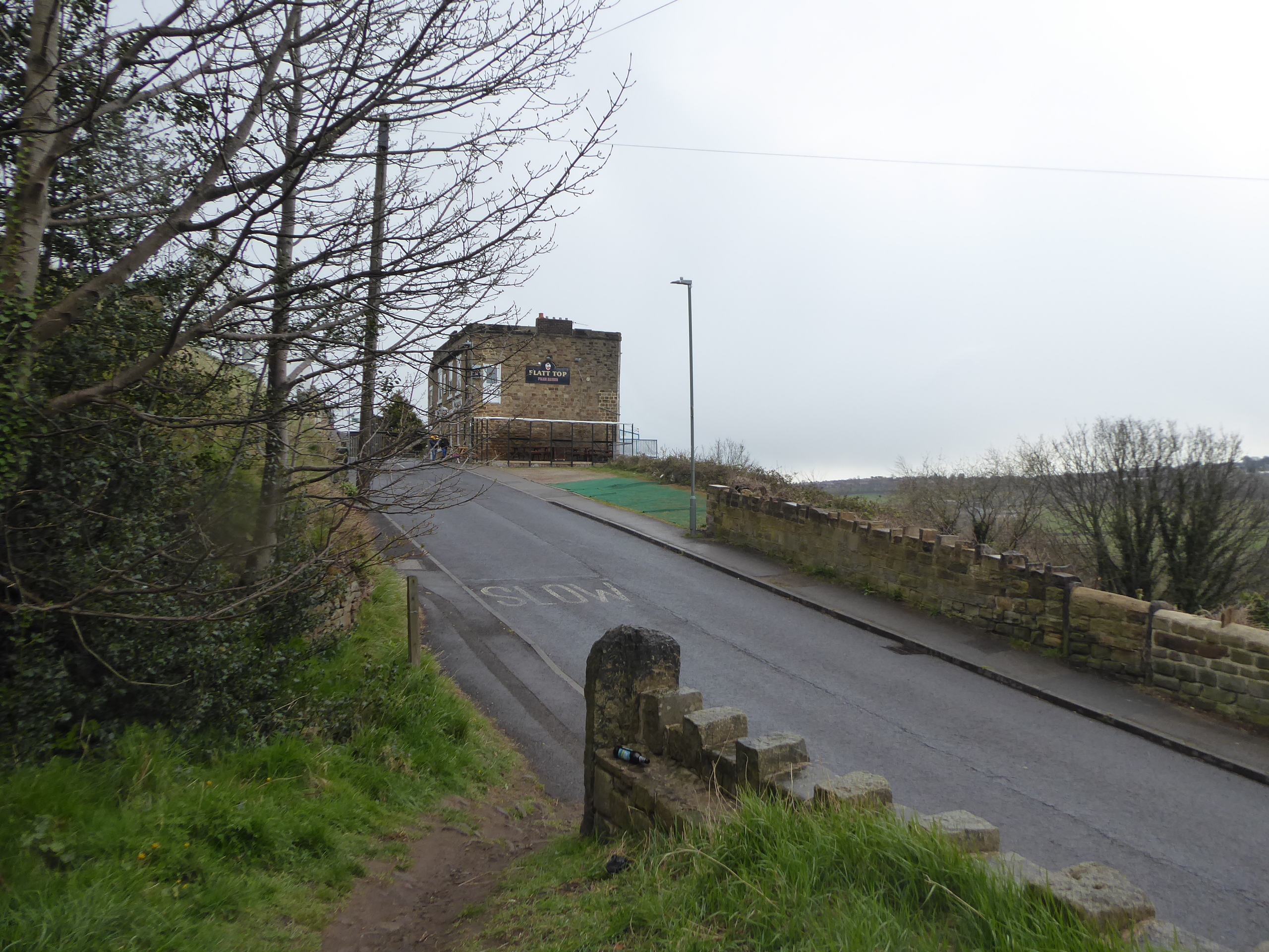
This narrow track, with its steepling drop down to the left of us is much easier going, and not fraught at all as we have it completely to ourselves as we pass east above the quarried scar edge and the three tiers of suburban houses below, noting that there hasn't been any more notable crumblage going on as we also look up to the council estate above which must have the best selection of staring windows in the borough, absorbing the view despite the gloom, from Whitley around to Middlestown, with the Emley Moor mast finally making its most proximate appearance on our tour. Tree cover crowds the views as the path drops down slightly, to meet Albion Road as it makes its long descent across the cliff face, and we rise with it up to the Flatt Top inn, where another beer garden of sorts has be assembled on the limited amount of flat ground around it, beyond which the suburban back gardens of Thornhill take over the views from above, while we settle into partial cover of trees once again, feeling like I'm the only walker who wants to use the path today, until I startle some kids who are having a play and are convinced that I'm an armed man. Of course, that's not the first time that my walking stick has been mistaken for an axe, and I'll pass on harmlessly as we come around the Edge End, or the Tops, if you prefer and take that sharp curve around the easternmost extremity of the path and rise in a suddenly northwesterly direction up towards the end of the suburban reach of Valley Road, at the same time as the prospect of the sunshine breaking through again feels apparent, though the chills and dampness endure as we land at the boundary of the suburban and estate sections of the village. The last rush of drizzle comes on as we arrive on the B6117 at Four Lane Ends, and we cross the first major road that we've seen in a while to join Rectory Park, which I've taken care to reconnoitre this time around after getting quite puzzled on my 2014 passage, so that we might pass around the playing field of Thornhill United and the fitness circuit to meet the descending path that leads between small woodlands, where the last snowfall of the year lingers on the ground, ahead of us meeting the recently developed wetland feature in the lower level of the park.
 |
| Thornhill Edge, tracking east. |
 |
| The Flatt Top, Albion Road. |
 |
| The Edge End woodlands. |
 |
| Rectory Park playing fields. |
The other important feature to note down here is the remains of the old Thornhill Hall, of which some foundations and a substantial soot stained wall endure within its watered moat, having been destroyed in the English Civil War and it's a site to detour into to soak up its unique atmosphere in its arboreal corner of the park, before we move on northeastwards, departing to Hall Lane by the ruined school buildings and the replacement Thornhill Hall, before passing below the local Cricket & Bowling club, and its tennis courts, ahead of the old MR Royston - Thornhill line. Straightforward progress here is ended as the easterly bridleway up to the canal is inaccessible to pedestrians, due to a lot of recent heavy plant movement, and thus we are forcibly detoured onto the alternative route, which we traced in 2019, west and then down below the rise of Mill Bank to join the Calder & Hebble Navigation by the eponymous lock and join the eastbound stretch of the towpath as it leads us on east, below old Midland Junction railway bridge and back around to Lady Anne's bridge, as blueness returns to the skies as we approach Figure of Three Locks. As we slip into Wakefield district, it seems that the plant movement has all been due to the Navigation having suffered an inundation by the neighbouring Calder in the wake of Storm Ciara at the start of last year, and the subsequent repairs are ongoing, a development which passed me by in 2019, and which we won't be taking a closer look as we drift onto the northeasterly path that joins the riverbank and passes below the railway bridges at the western end of Healey Mills yard, while we find ourselves among walking traffic that we haven't seen since the first stretches of the day. Cross over the Calder via the lattice girder bridge to return to its north bank, and the weather seems to immediate improve as we land at the weird eastern apex of this trail, thanks to the lack of river crossings further west, with Healey Road offering us the direct route up to Ossett which we walked when we last came this way, and the Wakefield Way also brought us this way in 2015, aiming us back up Old Mill Lane to enter the Old Healey Mills yard, dominated by Kerry Foods processing plant, which we have to skirt around along what feels like a more potentially dangerous path than normally found when walking in close proximity to active industry.
 |
| The remains of Thornhill Hall. |
 |
| The Navigation at Mill Bank Lock. |
 |
| The Navigation at Figure of Three Locks. |
 |
| The Calder at Healey Mills. |
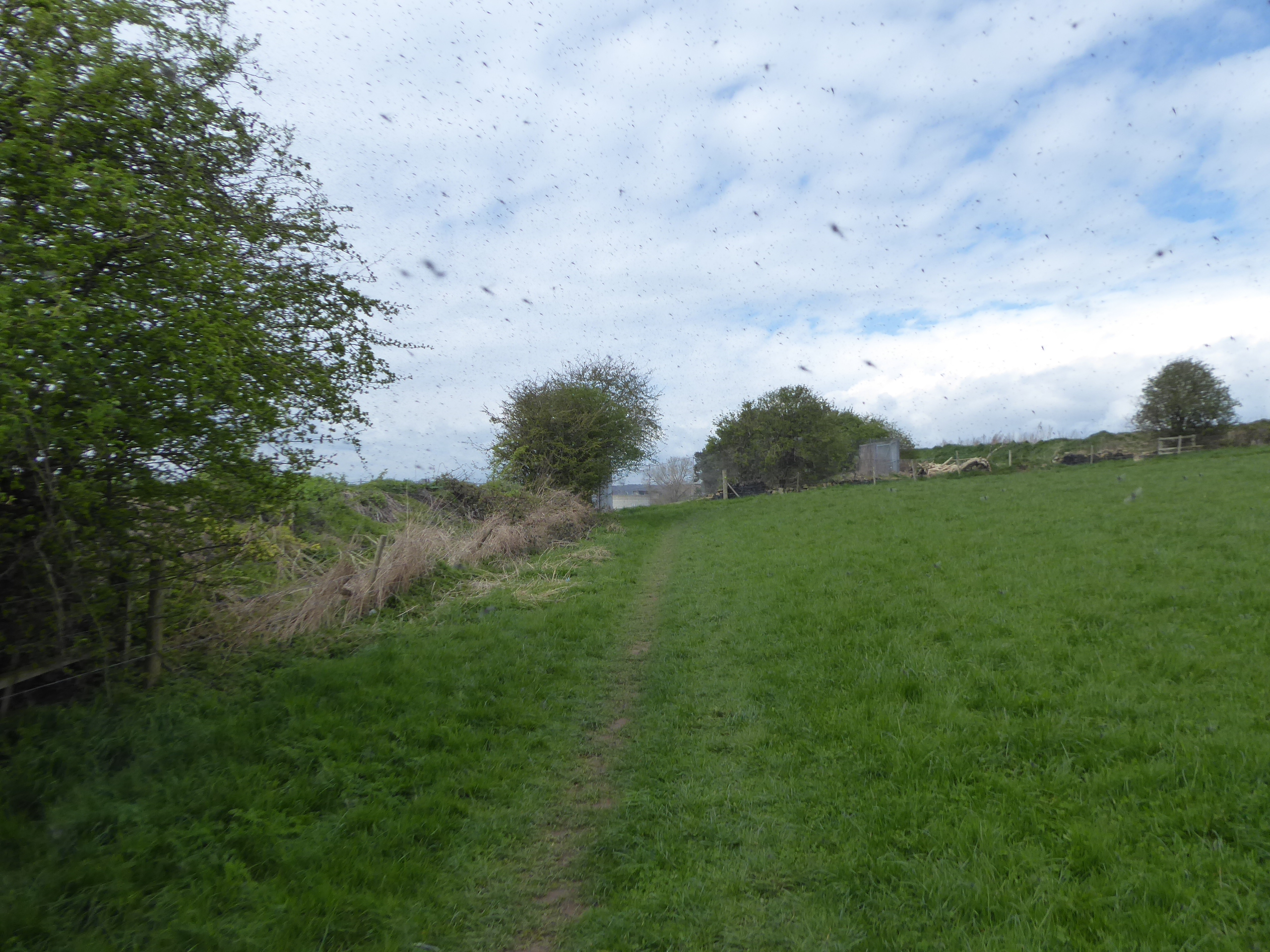
The Kirklees Way route leads us westwards into the open fields beyond, keeping to the boundaries as we pass around the sewage farm downstream from Dewsbury, where clouds of flies hang in the air around various trees, clearly attracted by the aromas of the nearby filtering beds, and it takes some vigorous encouragement to keep them from following me, as I'm surely not malodorous to appeal to them today, moving on as the path shifts north-ish, towards the lowest left corner of Ossett at Runtlings, up to that odd hairpin corner that send us west once more. A new plantation or two that have arrived in the landscape since our 2014 passage along here confuses the issue as paths split on both sides of it, and having picked the uppermost one of these, it becomes apparent that it's probably not the official route as it struggles to give us a clear passage over the drain of Pildacre Beck, and then starts to get tangled up in brambles, though our direction has tpo land us on the right of way path as it heads north again, which has me feeling that this might be a field landscape full of unofficial routes known to the locals but not advertised on any maps. Rise up to alight on the Dewsbury & Ossett Greenway, the former GNR line previously travelled, and we'll westbound along it, joining the local amblers out from Chickenley and Earlsheaton to enjoy the small bit of sunshine that the day seems willing to offer, tracing the alignment back into Kirklees district and down the slalom slope into the old Earlsheaton goods yard, and while the station site and the tunnel will always want to attract me, the official route splits off here heading south, into the landscape groove formed by Chickenley Beck. The Kirklees Way should have come this way in 2014 but didn't, and so fresh territory arrives in the final stretches of the day, as we emerge from the tree cover to hit a sharp rise onto the ridge that the railway dug its way below, field walking uphill across from the steeply stepped houses on Walker Street as we hit the crest on Long Lane by Woodbine Terrace, where we get our westward reveal of Dewsbury, or rather Savile Town, before we head down again, even more sharply, on the concealed path that is contained in the thick woodlands that coat the bank of Earlsheaton Common.
 |
| Flies fill the air, near the sewage works. |
 |
| A new plantation confuses the path location. |
 |
| The Greenway Slalom at Earlsheaton. |
 |
| The climb to the crest of Earlsheaton Common. |
Land on Sands Road, and follow Preston Street as it threatens to attracts us toward the tunnel again, before we find our way down to the playing fields below through the rough growth on the surrounding banks, landing us on the clear path that lead us to the bank of the Calder again, with the looming bulk of Headfield Viaduct ahead of us, with its stone arches rising over the fields and its Iron girders spanning the river, the other notable gem of the GNR's complex of lines in this area, which demands a brief detour for proper appreciation while we are in its vicinity. Sands Lane draws us west along the riverside, with the Calder sweeping around the industrial back yards of Savile Town on the south bank, and drawing us up into Dewsbury, below the commercial complex that occupies the long lost combined railway yards, where no trace of the L&YR's river crossing remains ahead if us meeting Long Causeway and heading in between the B&M and Sports Direct stores to meet the church yard of the Minster again as we pass its west end to seal the completion of our first proper way-marked trail since 2019. ~~~ With the first achievement of 2021 in the bag, it's then back to the station, and having rattled around the railway history of the town, we might as well visit all three as we go around the town centre, and so we press east again and pass under the A638 to soon meet the site of the L&YR's long gone terminus of Dewsbury Market Place, now a memorial garden in the shadow of the Town Hall, before we move up Crackenedge Lane to meet the GNR's Dewsbury Central, with its facades and hotel lingering below the ring road, naturally adjacent to the contemporary Market Place. Our final inbound leg takes us on, around the mildly active market and below Machells Mills as Whitehall Way leads us up to Bradford Road, which in turn lands us on the Ring Road again, as we follow its side around the back of Pioneers Hall, finally revived in use by Kirklees College, and up towards the still active L&NWR station, which has the local Covid testing site in its car park, concluding the day at 2.15pm, too late for the window of convenient local trains, but in good time to snag a ride to Leeds on a TPE Nova unit, not previously ridden on since the 802's introduction on these lines, 18 months ago.
 |
| Headfield Viaduct and the riverside playing fields. |
 |
| The Calder at Sands Lane. |
 |
D&DRCW completion means Selfies!
#4 & Final at Dewsbury Minster. |
~~~
 |
| Dewsbury Market Place Station site. |
 |
| Dewsbury Station. |
5,000 Miles Cumulative Total: 4870 miles
2021 Total: 127.9 miles
Up Country Total: 4407 miles
Solo Total: 4543.4 miles
5,000 in my 40s Total: 3467.8 miles
Next Up: A Weekend's Sojourn in My Calderdale Spupport Bubble.


No comments:
Post a Comment