4.2 miles, from Braithwaite to Whinlatter Forest Park.
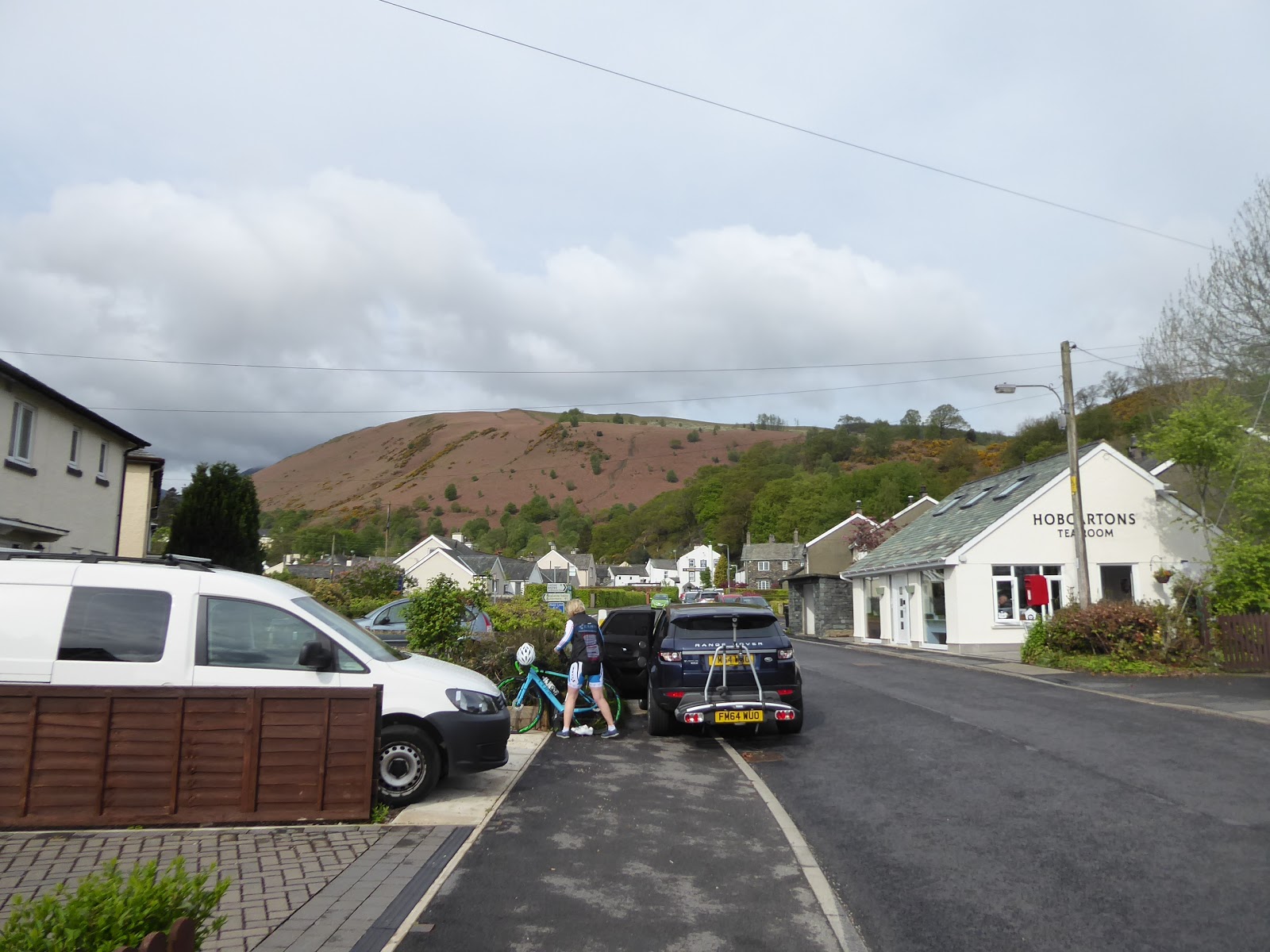
After the warmest Easter Weekend in recent memory, the very next one, when I travel over to Lancashire to visit My Sister and her family, brings an absurdly sharp drop in temperatures and constant rain that keeps me awake in the guest room in the loft after a Friday night of hitting the sauce, and washes out any possibility of us attempting the green road to Manchester from her abode in Egerton, leaving Saturday only good for doing some shopping in the big city, while dodging the precipitation the whole time. Sunday also looks like that it's not going to allow for much as Dr G and the girls have been booked onto a Mountain Bike Cyclo-Cross race in Whinlatter Forest Park in the northwest corner of the Lake District, two hours distant from greater Bolton and surely too far away for any consideration of approaching a Lakeland fell when I'm surely going to be needed as chaperone or spectator. So after suggesting that we two non-riders go up Grisedale Pike, pretty much on a whim, I'm surprised when My Sister agrees to this, and thus we travel away on Sunday morning with this idea in our heads, both expecting the other to call it off, with me anticipating her to claim timing problems while she expects me to bail due to not being an able hillwalker, and neither of us is expecting the weather to be good enough for a cloud free ascent, so we're both surprised to get as far along the A66 as Keswick and find the skies clear and the way ahead looking walkable, as the peak rises invitingly above the North-western Fells. So we get dropped off in Braithwaite village at 9.35am, just by the Hobcarton tearooms, (and far away from where I'd been anticipating walking this weekend or indeed this year) with 700m of ascent to look forward to as we set off up the B5292 Whinlatter Pass road, rising through this lovely Lakeland village, where everything is coated in whitewash, be it semis, council houses, holiday properties or miners cottages, passing the Royal Oak inn, the orthodox church and the well contained Coledale Beck. We don't have a sightline to the summit as the road pushes beyond the village, obscured by its easternmost ridge as we press uphill to the small access carpark, where we rapidly get off road and start rising on the path that tacks north to put Skiddaw and the bottom corner of Bassenthwaite Lake ahead of us, before shifting around onto a southward stretch to look over Braithwaite and Keswick to Derwent Water and the wooded top of Swinside, with the High Seat and Helvellyn ranges on the eastern horizon.
 |
| Braithwaite and the hill climb to come. |
 |
| Basenthwaite Lake and Skiddaw. |
 |
| Above Braithwaite and Keswick, with the Eastern Fells beyond. |
I'm glad that My Sister lent me a pair of walking poles, as I hadn't brought a stick, as even as we press on up through the open plots of dead bracken, the pitch of the ascent is stiffer that the ones I'm used to, as Lake district contours pack together at 10m intervals rather than the regular 5m, meaning that a tough looking route is actually even worse, and we burn off the groups of older walkers as we rise to the westwards trajectory, which places Coledale to the south of us, with Barrow, Stile End and Oughterside above it, with Causey Pike elevated beyond. It's a view we lose over the next 100m or so as the grassy path pushes us away from the high edge of the valley, but at 350m up the path levels off, and gives us clear sight of the way to the summit, 400+m further up, as we need to rise up from this initial sub-ridge onto the main eastern ridge, and follow the sharp edge all the way up for over a mile, though we've a steady climb to come before then, wandering over the moorland turf as Coledale reappears far below with our eyes drawn up it to the Force Crags, and to Sail and Crag Hill at its western end. After a watering break, augmented by sweet treats from Tebay services, we shift onto the rise to the eastern ridge, for a tough but steady 150m of elevation, up through the heather line and really testing my calves and thighs that normally don't do sustained uphill stretches, a climb that really enhances the view back, as Blencathra appears among the Northern Fells, and Derwent Water expands to its full visible length far below, and gaining the Sleet How ridge top gives us a view north at last. Here we can look down into the valley of Grisedale Beck, mostly concealed from view below by Hospital Plantation, which we can look beyond to the bulk of Whinlatter Forest, with its eponymous hill above, with the viewpoint summit of Lord's Seat beyond it, while we can now see the full length of Coledale, it's silver ribbon of beck flowing east from the lead mines (abandoned as recently as 1991) and the waterfalls coming down off the Force Crags and on down to the River Derwent (no, not that one, or the other one), as we enjoy a much gentler 50m of climbing.
 |
| Grisdale Pike, with Outerside, Sail and Crag Hill. |
 |
| Ascending to Sleet How ridge. |
 |
| Coledale, with Force Crags and Lead Mines. |
 |
| Grisedale and Whinlatter Forest. |
The high climb is to come, and I'll insist we pause to let younger legs get ahead of us, feeling happy that the sunshine is being kept off by a layer of high, fine cloud and that the wind is minimal as we set off for the last upwards push of 150m or so, letting My Sister take the lead as she picks out the best route over the exposed and loose layers of mudstone and siltstone, with her blazing ahead of me as her cyclists muscles give her a useful boost on this terrain, while I toil hard once again, convinced that my hillwalking technique just isn't up to scratch. The climb keeps on going, and can feel precipitous if you drift too close to either edge of the walkable route, and due to the uneven outcroppings of rock, with far too mush loose stuff around, zig-zagging becomes the only appropriate walking fashion, while My Sister leads the way assuring me that every false summit along the way isn't the top, bless her. If we'd had a higher climb to do, my brain might well have quit on me, convincing me that I'll never make it as a mountain man, my confidence in my ability probably having been compromised after watching the exploits of truly bold climbers in the Netflix film 'The Dawn Wall' the previous evening, but this is not a summit to defeat me, and the haul eventually ends as we hit the summit cap and the 791m top of Grisedale Pike awaits not to far ahead. The ascent has taken us two hours, and we arrive at the distinctly unimpressive cairn just as a band of low cloud passes over, having spent most of the day only concealing the tops of the 900+m fells, but it's not enough to spoil our view, over to the higher pair of North-western peaks, Crag Hill (or Eel Crag?) and Grasmoor, or south to the distant wrinkles of the Western fells, which don't feel too remote from up here, as doesn't the Solway Firth, off to the north, which shrinks down the distance between Great Gable and the Hadrian's Wall path, the closest previous walked points up this end. A loiter up here, among the other crews passing over here, would appeal as would a push over to Hopegill Head and its subsidiary peaks of Sand Hill and Ladyside Pike, we still have a date to keep in the forest park and thus we have to go down again, with this trip adding only one more Wainwright, the 40th highest, to my unimpressive list of only three previously achieved summits over the last 14 years.
 |
| The High Ridge walk, looking up. |
 |
| The High Ridge walk, looking back. |
 |
| Grisedale Pike's 791m summit cairn, with Crag Hill and Grasmoor. |
 |
| The northern ridges and our descent route. |
So down again, and My sister picks the route down, choosing the middle one of the three ridges that come off the summit, eschewing the Hobcarton End route that I might have favoured and instead picking out the path that descends steadily by the long and broken dry stone wall as that's the one that leads most directly down to Whinlatter Forest, as that sits on our nearby horizon, with the Northern Fells arising around Skiddaw to provide our backdrop for most of the way down. It's not as intense a path as the Sleet How ridge path, which looks pretty scary from this angle, and also distinctly busy with lunchtime walkers, but the way down is at such an angle that you ,literally have to totter the whole way down, like a slightly off-balance toddler, or how you would go if having to hurry down a slope in high heels, according to My Sister at least, and we are glad we chose this route to come down, unlike the Geordies pushing their mountain bikes to the summit, or the guy blasting his way up with his black Labradors. Contextual views around gradually diminish, as the summit cap retreats and we lose the view over the valley of Sanderson Gill as we descend to the lower portion of Grisedale, with only forest and Skiddaw ahead of us, but trust in dead reckoning, and the OS app, and the certainty of a complete path, eventually has us meeting the tree line after a steady drop of 450m, and the way forwards into Whinlatter Forest Park is aided by clearly marked cycling trails that take us over the descending becks and on though the trees. Alertness is needed to not get run down by those who cycle, but we are apt to such things, even when distracted by the utterly alien looking carpet of moss that covers so much of the ground below the conifers as it leads us to the B5292 road again, and we can thus follow the route into the car park and up visitors centre to conclude the trip at 12.45pm. Then we'll just have to find Dr G and the Girls, located on the Revelin Moss trail just as Elder Niece completes her circuit, and then we'll have to get ourselves fed and the Girls kept occupied while Dr G races with the 'Dads', with all the riding done by 4pm, and even then we have time to haul us all back to Lancashire so I might be turfed out onto the train at Bolton, and still manage to get back to Morley before it gets dark, which gets me believing the Wainwright-ing with My Sister could be an entirely plausible feature of my walking career in the coming seasons.
 |
| Looking up the north ridge to the summit. |
 |
| Descending to Whinlatter Forest, with the Northern Fells. |
 |
| Moss Carpet in Whinlatter Forest. |
 |
| Grisedale Pike from Whinlatter Forest Park. |
5,000 Miles Cumulative Total: 3791.7 miles
2019 Total: 141.3 miles
Up Country Total: 3398.6 miles
Solo Total: 3501.2 miles
Miles in My 40s: 2355.5 miles
Next Up: West Yorks to South Yorks over May Day weekend.


No comments:
Post a Comment