So the travelling to new lands starts here, fortified with new socks, because if Mountain Warehouse are going to keep giving me money off vouchers, I'm going to keep on shopping there, and wearing my new woolly pair, it's off the train at Bramley just before 10.30am, hopeful that I'm going to miss the worst of the weather that has been projected, and that the snow that fell yesterday hasn't left any awkward going between here and the Wharfedale fringe. So northwards, across Stanningley Road, and letting Hough Lane guide me along its kinky course among Bramley's terraces to crest the hill by St Peter's parish church, with its notable landmark spire, and to meet the A657 Low Town Street just above the Bramley Shopping centre, and a fine view over the Aire towards Leeds could be had here, only if you could gain that extra bit of elevation. Hit the main road for a stretch, spotting the old bits of Bramley that were here before the city consumed it, before finding the convenient alleyway that cuts the corner over to Broad Lane, and the day starts to warm through as Newlay Lane brings a more suburban aspect, and once over Leeds & Bradford Road, Pollard Lane provides an altogether leafier aspect on the descent to the riverside. Bramley Fall Park seems a tempting location, offering rough paths among the woodland and former quarries, but I'm heading over the canal, railway and river, cramped together at Newlay, where the Aire is looking pretty busy with post-snowfall runoff as it churns below Pollard bridge. Newlay Lane on this side gives an altogether more expensive face, and that's the story along much of this quarter, the expensive Victorian villas standing on the rise away from the river, and across the A65, Outwood Lane is a bit more modest in scale, but no less desirable, hung above the deep wood cleft of Hawksworth Clough. Press on through Horsforth Woodside, where extensive residential development never quite put an end to the many local woods, clinging to hillsides just that bit too steep for building upon, and pass across the A6120 Ring Road and onto Low Lane before hitting the rough path down to Old Mill Beck, which is also having a fierce churn with wintery runoff.
Hit the rising track into Clayton Wood, thankfully easily traceable as the dense and almost primordial woodland cover comes as a bit of a surprise, elevating significantly to pass over the line to Harrogate (thus having passed across all of the main lines into Leeds over only two walks!) and the track evens out as it skirts the perimeter of the vast disused quarry that hides in the trees, and how this hasn't been developed as a premier off-road biking track, I'll never know. Sticky going, as the woodland is cleared, emerging onto Silk Mill Way, and Iveson Drive leads me into Ireland Wood, which is more council estate than woodland, but there still a lot of leafiness going on around the house, and this whole corner of West Leeds seems to be an area of bus destinations, which I seem to know very little about. Pass onto Hospital Lane, once the driveway to the Cookridge Oncology unit, closed once the Bexley Wing at St James' opened, but whilst that seems to be a long time ago, it's still within the time that I was working for the Leeds Hospitals (odd to think my visit there was 12 (!) years ago), and then we move to Otley Old Road and Tinshill Moor, an obvious destination as the Microwave tower at its top it the North Leeds standard candle. Actually it's nowhere as vast as its prominence makes it appear but it's worth a look up close, as is the view back across the playing fields, a completely fresh view towards the city centre, and the odd appearance of East Leeds being apparently covered in trees, as it's hidden behind the wrinkles of Scotland Wood and Meanwood. Keep going north, as the Old Road provides a split between Cookridge and Holt Park, about as marked a split in terms of prosperity and proximity as you can get, and I'll slip through the former along Moseley Wood Lane and Avenue, noting that the Methodist church and Holy Trinity parish church chose distinctly similar styles if they didn't share an architect. Hit the edge of town by the cricket field, heavily flooded on this weekend, and home to ducks in the out field, and passing over the Leeds Country Way route, we strike out onto the lane to Crag House farm, a notable nursery and farm shop where a whole tonnage of extra roads have developed since my ancient E288 was printed.
Out into the fields and despite all the wittering I have already done, the day is about to get interesting, as once the interest has turned away from Leeds-Bradford airport up on its hillside, attention turns to back to ground level, and whilst I'm starting to run short of railway relics on the many closed lines in the county, I can still go looking at the ones that are still active, and that's what we'll be seeking today. Having seen the south portal of Bramhope Tunnel four years ago, it's now time to seek out the rest of it, and the southernmost airshaft is soon located, complete with the spoil heap that has been there since it was constructed in 1845-9, and the spoil tips are going to guide us all the way to Bramhope itself, as the surveying standards if its day needed many shafts to be dug to keep the alignment accurate, possibly totalling a greater depth than the tunnel is long, 2 mile if we're keeping count. Extremely damp going over the Otley Old Road, the fields and path being completely waterlogged and gooey, indeed candidates for the worst encountered so far, getting my boots, trews and E297 appropriately filthy, before passing more spoil heaps on the way to air shaft #2. Onwards to the most interesting relic of the tunnel's construction, the sighting tower on the Moor Road - Moorland Road (?) corner, built to give an the works supervisors an elevated overview of the alignment and a remarkable survivor seeing as it could serve no purpose at all once the building work was completed. Onwards into Bramhope, on the wooded track past air shaft #3 and even as you pass into the parts of the village that grew in the late 20th century, the spoil heaps are still there, clearly too difficult to remove, and it does answer the ponderable idea that the recreation area between Parklands Gate and Breary Lane might be built on an ancient motte, nope, it's tunnel spoil. Down the ginnel to the A660 Leeds Road, and then steeply down the track by air shaft #4, finding the paths in the expensively developed northern half of Bramhope have gotten somewhat obscured, but that doesn't prevent me finding the way into the Creskeld hall estate grounds to get a closer look at the crenelated and battlemented north portal of the Tunnel. Not that I'll be loitering too long or getting too close as this is private property and an active railway, returning on the track to Hall Drive for a lung bursting rise back to Leeds Road, and getting some fine views into Wharfedale too, a nice place to live if you've got £1M drop on a house, finishing at the Puritan chapel at 2.10pm, just in time to catch the X84 and happy to report no foot-related problems on any kind.
5,000 Miles Cumulative Total: 2050.6 miles
2016 Total: 36.2 miles
Up Country Total: 1876.9 miles
Solo Total: 1820.5 miles
 |
| St Peter's Bramley, an impressive spire for the West Leeds horizon |
 |
| Pollard Bridge, Newlay, established in 1819 and a key crossing point on the Aire betwixt Kirkstall and Calverley, one I feel that might get used a lot in my walking future. |
 |
| Outwood Lane, Horsforth Woodside, where expensive dwellings and wild woods endure side by side. |
 |
| Clayton Wood quarry. If I had the commercial nous, and the revenue, I would make this the premier site for off road cycling in the county! |
 |
| Tinshill Moor Microwave tower, good to finally see it up close! |
 |
| Cookridge Cricket Club, with only ducks tending the outfield. |
 |
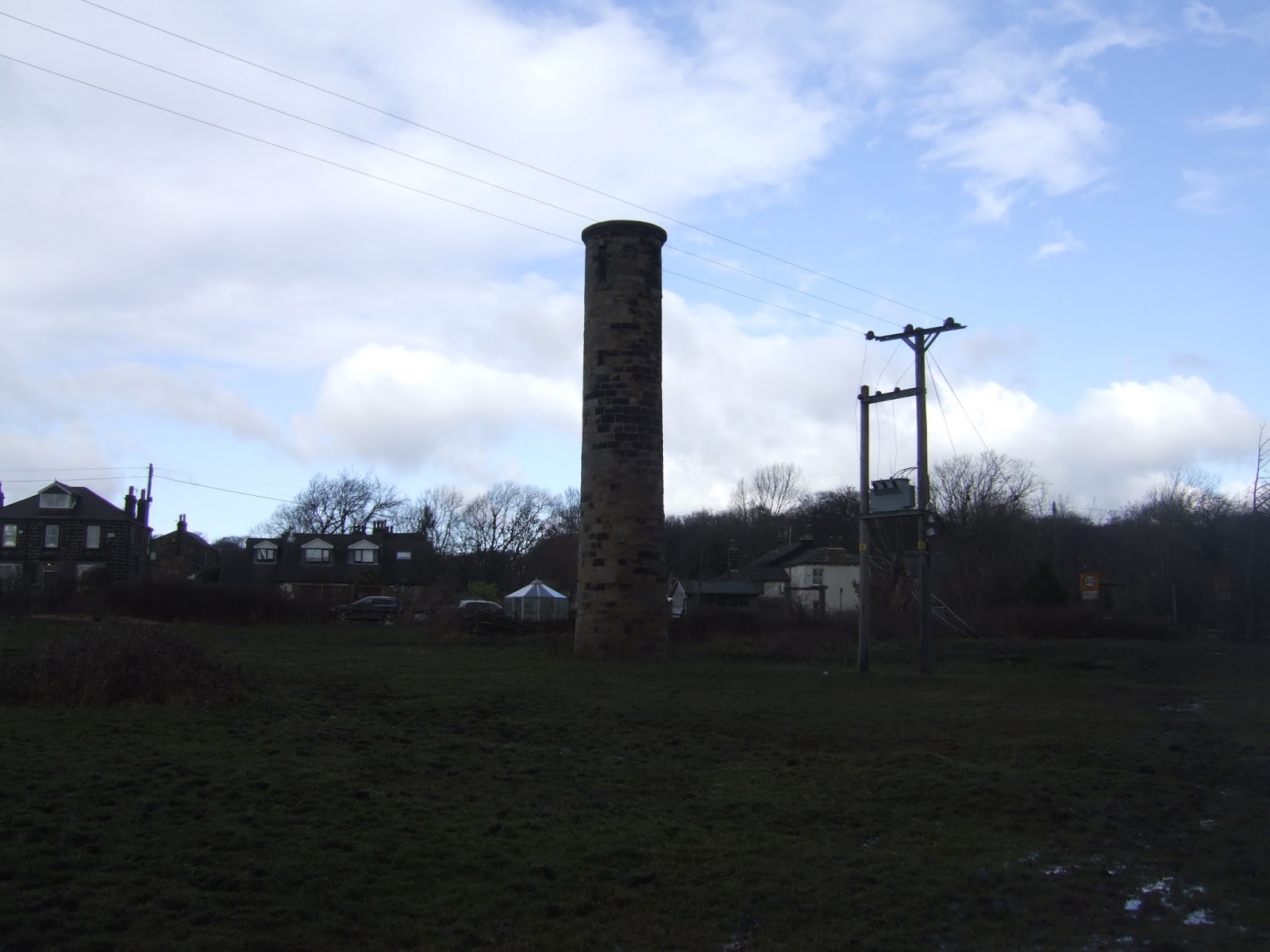
| Bramhope Tunnel, air shaft #1. The quality of the work of the Victorian engineers and navigators has to be admired, even at this remove. |
 |
| Bramhope Tunnel, sighting tower. Not a lot of these left anywhere in the landscape, a useful reminder that tunnels were once navigated with nothing more complicated than long sticks and a sextant. |
 |
| Bramhope Tunnel, air shaft #4. Hidden in plain sight next to Leeds Road. |
 |
| Bramhope Tunnel, north portal. Castellated to be a feature on the Creskeld Hall estate, and not that easy to access, one of those sites that deserves to be a lot more public than it is. |
Next on the Slate: Airedale to Wharfedale by a surprisingly green corridor.
No comments:
Post a Comment