16.7 miles, via Cobden, Willow Bank, Hole Bottom. Whirlaw Stones, Stony Lane,
Mount Cross, Stiperden Bank, Stiperden Slack, Hoof Stones Height, Black Hameldon,
Hare Stones Hill, Gorple Gate, Clough Head, The Brinks, Flaught Hill Tom Groove,
Hey Slack Clough, Boulsworth Hill (Lad Law, Weather Stones, Little Chair Stones,
Little Saucer Stones, & Great Saucer Stones), Pot Brinks Moor, The forest of Trawden,
Hollin Hall, Trawden, Winewall, Cotton Tree, and Colne Field.
Another August weekend proves to be unusable thanks to another bout of unseasonably awful weather, which at least allows me a clear couple of days to be domestically sociable as My Mum travels Up Country on a flying visit, though it frustratingly denies me the opportunity to abuse my Parental Taxi privileges while I continue to tilt at the passage over the northwestern hills of West Yorkshire, so enforced rest comes on as I quietly curse out what has been easily my most disappointing Summer so far, at least until the long Bank Holiday break turns out to be the first warm one in six. Thus we get back to early starts on our trailing, and alight at Todmorden station at 8.20am, arriving in the upper reaches of the Calder Valley under the brightest of skies, a sight which we've really missed and will enjoy all day as we start out descending, down Station Approach and finding the shortcut path that I knew existed beneath Todmorden viaduct, taking us down to the A646 Burnley Road by the bus station and the new branch of Aldi, turning up the valley to follow the road into the quarter of town, nominally Cobden (or Patmos) that we haven't seen too much of previously. Past the shopping parades and Todmorden Community College, we get a frontage of townhouses along the main road, and we manage to distract ourselves from out intended route out of the valley by missing our northward turn as we traipse past the cricket field, crossing by the lodge house of Centre Vale park and rising into the landscape of post-industry and terraces, up West Street and Blind Lane to get back on track with Victoria Road, taking us under the railway as it rises up the Copy Pit line, and get our ascent really going as we hit Meadow Bottom Road. Rising up the clough of Willow Bank with short terraces flanking the road, we soon land by the site of Todmorden Laundry, with one cottage using its former chimney as a turret house of sorts, beyond which the lane starts a twisty path up hill, passing around the cottages and farmstead that have been dug into the rising hillside, and getting some early shade as we elevate up towards Hole Bottom, giving us some respite from the breath-testing ascent before we tangle up with the Calderdale Way path as it takes its turn up through the trees.
 |
| Burnley Road, Todmorden. |
 |
| Meadow Bottom Road, Willow Bank. |
 |
| Hole Bottom. |
Scrapers Lane projects us through Bents Wood and up to the high apron of fields above the uppermost Calder, taking a turn behind East Whirlaw farm to meet the more even going up the valley as we skirt below the looming purple bluff of the Whirlaw Stones, the prominent feature to be seen from the town which conceals the sight lines towards Bridestones Moor, and giving us a path with a fine southern panorama to enjoy in the low sunshine, illuminating the Calderdale and Rossendale flanks, as well as the valley that bisects them, as we track through the heather and long grass. Land on the end of Stony Lane, the seeming ancient track that must have been one of the old route up the valley in days of yore, which tracks us below the rocky outcrops that could easily be mistaken for the Bridestones, and another purple nab that could be misidentified as Whirlaw Common too, and we track along this uneven track as it passes the ruin of Spring farm, before we arrive below the western edge of the Bride Stones themselves, just a step too high up to really reveal their drama as we pass by. Attention thus shifts forwards, as we break off the CW route and strike west further the next wrinkle in the valley side reveals the Hawk Stones rising on the moorland edge above, and the Coal Clough wind farm whirling away upstream, as the sunshine gives it all a colouring that is much less bleak looking than when we saw it a month ago, and we fix ourselves relative to the northeastern flank of Rossendale across the valley as we keep on worth this high bridleway, where navigation skills aren't tested at all on our chosen trajectory. The fields up here, well above moorland altitude are so marginal that it's hard to believe that they might have ever been effectively agricultural, but as we come up towards the end of the track, now named Delf Lane, we actually have to skirt around one which is still habitable, Lower Intake, with its driveway leading us out to pass the Mount Cross, and ancient marker that gives credence to my theory of this route's vintage, before it deposits us out onto Mount Lane, by the Mount farmsteads, the last signifiers of habitation that we'll be passing for a very, very long time.
 |
| Whirlaw Stones. |
 |
| Harley Wood Slack, the false Bride Stones. |
 |
| Stony Lane, and the Hawk Stones. |
 |
| Mount Cross, Delf Lane. |
It's brief but steep push up here to get us up to Kebs Road, the other old lane on this valley side, and to again join the 400m contour-hugging route as it hugs the edge of Stiperden Bank above the depression formed by Pudsey clough, coming soon around to the Yorkshire Lancashire border and our route onto the open moors and the long ridge walk to come, and having steeled myself to test the conditions underfoot, I hadn't anticipated the possibility of shooting closing the moors, but a red flag suggests its a risk today, one which I'll boldly ignore as I see and hear nothing. Reconnoitering this path online did much to assuage my fears of the open moors, as there's a clear trod rising to the north to follow on the Lancashire side, keeping us away from the wetness of the descending stream and keeping us on firm going through the long grass and blanket of purple heather, and the 80m of ascent from the road to the first summit passes easily, without it even feeling like an effort after the early push of this trail, as the Calderdale and Rossendale horizon rises behind us, and showing up the Pole Hill VOR array in the landscape ahead of Stoodley Pike. Thus Hoof Stones Height is met, at 479m up to make the first summit of the day, revealing the ridge walk to come, looking way flatter than anticipated and attracting the eye all the way up to Boulsworth Hill on the far horizon, while we can look left to the East Lancs Valley, with Pendle Hill rising and Burnley sitting below, with is prominent features being Bank Top viaduct and Turf Moor stadium, as West Yorkshire gradually ripples away to our right, and a studied view to the southwest places Winter Hill rising in the distant West Pennines far beyond the ripples on both sides of Rissendale. The good weather feels like an absolute blessing for a location like this, where we might take in so much of the landscape that we have been traipsing through this year, and we resume north after our early elevenses break, easily locating the fence that will be our clear guide over the Hameldon ridge, settling onto the West Yorks side and soon finding ourselves tracing a shallow ditch which tracks down into the depression on the northern side of the hill, barely losing 10m of altitude on the way down but being just low enough to lose sense of an horizon on either side, despite us now tracing our way along the English Watershed.
 |
| The Hameldon ridge is closed for shooting, apparently. |
 |
| The Calderdale horizon from Stiperden Slack. |
 |
| Hoof Stone Height, the trig pillar and the way to come. |
 |
| Traversing the moorland ditches to Black Hameldon. |
No worries at all about the route ahead though, as once over the ditches at the lowest part of the lea, we rise again gently onto the 470m flat top of Black Hameldon, the central summit plateau of the ridge, where a trod take us over some turf and red grass that could have been testing if the weather had been persistently wet over the preceding days, the peatiness being indicated by the name of the hilltop, and its dryness might have been aided by the drainage works that have been put in place here, as another ditch tracks down over the side to the second depression. Another slightly damp and muddy passage is made over the ditches to gain our way onto the third hill of the ridge, which seems to have not been named in a distinct fashion, despite it forming the most distinctly shaped and prominent portion of the moorland, with its 465m plateau top affording more panoramic views ahead, especially as the clough of Thistleden Dean opens out ahead, and the downhill shift starts, tracing the fence to the northwest on a clear path through the evergreen shrubs, revealing Gorple Upper reservoir in the landscape below to the east, and sending the eye over to the Gorple Stones on the side of the next hillside along, which also lacks a name. Its some 65m sharply downhill to get to first break in this ridge, where no remnant of an ancient track seems to remain, possibly due to reservoirs being contrasted on both sides of the watershed ridge, and having bottomed out here, it's immediately time to climb again, with our way still obvious as we rise up Hare Stones Hill, and up to its eponymous gritstone outcrop, notable for having a millstone that was carved and abandoned in situ among the rocks, and it's a good place to pause for lunch looking down to Cant Clough Reservoir on the Lancashire side and to listen to distant voices being carried on the breeze, drifting down from the Pennine Bridleway. There's a right of way to join as we rise towards the Gorple Gate path, though it's not much better going than that which we travelled over the Hameldon ridge, which now rises impressively behind us and we'll wander a bit to to examine the rockiness on the edge above the drop to east, finding a boundary stone that seems to have been moved some distance away from the boundary fence, an alignment that we are now to abandon as we alight on the rough track of the Pennine Bridleway, after a solid 85 minutes of having the moors entirely to ourselves.
 |
| The Hameldon Ridge from Black Hameldon. |
 |
| The upper Calderdale horizon, from Hameldon Ridge. |
 |
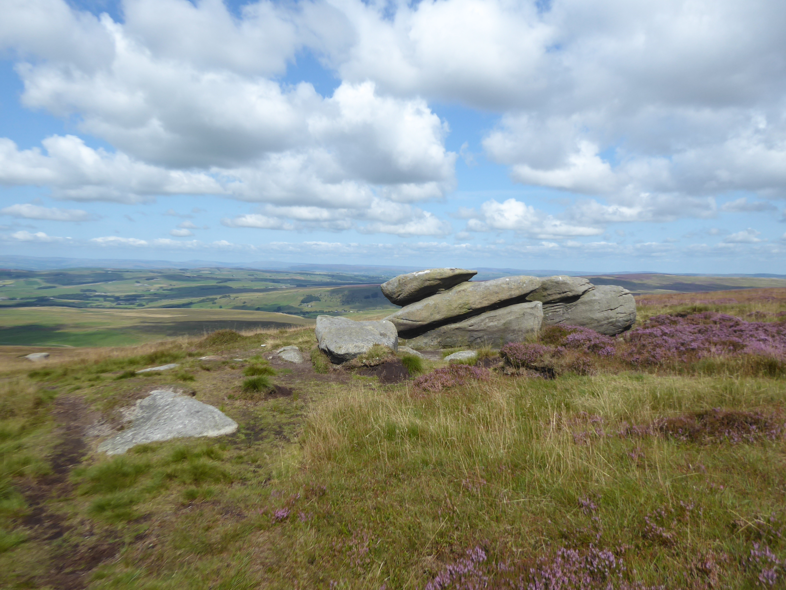
| Hare Stones Hill, and Gorple Stones. |
 |
| The boundary stone, and Cant Clough reservoir. |
Gorple Gate hardly forms the busiest track we'll be meeting on our travels, but we have cyclists tootling over in both directions, in the shadow of the Gorple Stones, exposed on the face of the nameless hill that we shan't be traversing a way over the top of, largely due to its lack of an obvious route off its northern side, and thus we'll stick to the track above Upper Gorple reservoir, and the walls of what was once the Gorlple farmstead, long since abandoned at over 400m altitude, and soon in our wake as we rise on the cresting path north of the outcrops on Shuttleworth Moor. It's fresh and distinctive look across West Yorkshire that we get as we rise over the edge of Little Hill, with the PBW track wandering away from the view down to Lower Gorple reservoir and Hebden Dale, and angling us across towards Widdop reservoir, giving possibly the best look of the heather-clad hillsides above Greaves Clough and Walshaw Dean to the northeast, where the Pennine Way tracks over, that we'll probably be getting this year, as we settle into a groove that angles us sharply downhill towards the Cludders Stones and the southeastern reservoir shore. We need to track northwest to get back up to the watershedding route we've chosen though, so we split off at Clough Head and join the footpath that runs in below the looming hillside of the Brinks racing the side of a gradually descending wall above the southwestern side of Widdop reservoir, following the route of the Burnley Way on the wrong side of the Pennines and finding us some damper going than we met on the high moor top as we drift downhill far enough to land ourselves in the sea of bracken that comes downhill from the Clattering Stones above the tightening valley head. The reservoir soon in our wake, we follow the path as it sits on the southern side of the feeding streams, with us not taking the easy escape route over the footbridge up to Ridehalgh Road, instead tracing the path through the heightening bracken using foot placement as much as eye sight as it take us up beyond a pair of dam-lets and sharply down to the stream crossing below Flaught Hill, a spot where it would be easy to become unstuck, as would be the path up on the far side, where the instinct to rise upwards away from the wrinkled upper clough is sure to lead you to the tarmacced road eventually.
 |
| Upper Gorple Reservoir. |
 |
| Widdop Reservoir. |
 |
| The Clattering Stones. |
 |
| The stream passage, Flaught Hill. |
So back where we were on our last jaunt out, having travelled quite a different route to get here, re-pacing the route up and down to Tom Groove, and passing back over the Yorkshire - Lancashire border again, decisively this time, entering that elusive parish of Briercliffe and soon finding the footpath that elevates us out of the furrow that the ascending road runs through, elevating us just enough to give us a different prospective of the rising hills on the watershedding ridge as we come up to Widdop Gate and its renewed viewpoint over Pendle district. From here, after watering, we can aim to our second moorland traversal, while not feeling any of the tiring effects after the preceding rough walking, and so a right turn is taken on the path that will take us on to Boulsworth Hill, initially rising with the old shooting track as it heads up the watershed on the flank of Grey Stones Hill, gaining enough height to restore much of the southern horizon, placing Winter Hill back in visual range, and even adding Darwen Tower to the far landscape, while we convince ourselves that we really ought to be able to see the Irish Sea too. We lose the watershed, drifting to the east, ahead of us cresting over into the depression formed by the natural amphitheatre formed by the upper reach of Black Clough, with main bulk of Boulsworth Hill sitting to the west of it, as Peacock Hill rises ahead and the craggy ridge of the Dove Stones sits to the east, the sort of landscape that you cannot see without deliberately venturing into it, where the descent of the track briefly loses all of the surrounding horizon as our route dams its way over a moorland lagoon. It's a slight rise beyond to get to the head of the track, where a parking area of sorts clearly once had someone driving doughnuts upon it in the past, and we've some rough walking to come as we make a crossing of Hey Slacks Clough, the only major obstacle on the rising path to Boulsworth Hill, and despite there being no formal path this way, it's clear from the quality of the trod that most using the open access privileges make an approach from this angle as it starts up a rise over the Hey Slacks apron, across some surprisingly friendly moorland turf.
 |
| The nameless hill, which we didn't traverse. |
 |
| The watershed track, on Grey Stone hill. |
 |
| Boulsworth Hill, Peacock Hill and Dove Stones. |
 |
| Hey Slack Clough and Boulsworth Hill. |
The challenge naturally comes once the ascent to the summit cap has to be made, as the sharpening edge of the highest hillside rises some 40m above the moorland apron, as tough press as the afternoon sun beats down, a heat effect that I'd almost forgotten about after all these cool weekends, and as we rise onto the slab known as Lad Law it become apparent that this most attractive of tops, with its pair of 517m summits has other folk upon it, with one man and his dogs rather spoiling the solitude with his dogs and drone. Still, it's not enough to spoil the experience of reaching the top of this quarter of the moors, where a fully panoramic view across West Yorkshire and central Lancashire can be absorbed, and eyes can be cast up to the western Yorkshire dales, and down to the Cheshire side of the Peak District, if my orientation is correct, and we'll pause here, to fortify with lunch, not nearly as late into the day as my head might have expected, admiring the wind-carved rock formation that looks like a howitzer or a gloved hand, pointing to the west. Having made all the effort to get up here, me might as well make the most of seeing as much of Boulsworth Hill as there is to be gleaned, as there's more to it than just the Lad Law plateau, as the 517m trig pillar sits away to the northeast, surrounded by more sculpted rock and which affords us a better view down to the Forest of Trawden and the route that the Bronte Way brought us down on the western side back in May, where we'll be aiming down, though not via either of the permissive route which rise up this far flank of the hill. We slip off the high top as we progress on, but staying on the rib of the hilltop as the slight descent to the Weather Stones is made, a short trek across a rough and occasionally soft path to the point where the English Watershed touches this ridge again, and the most attractively formed rock outcrops can be found, with one shaped like a basin and another looking like a modernist baptismal font, with the whole lot looking like they've been carved by the wind for centuries without having been disturbed by the human need to quarry them away, preserved for posterity be being too far away from anywhere.
 |
| The ascent to Lad Law, Boulsworth Hill. |
 |
| The Howitzer / Gloved Hand stone, Lad Law. |
 |
| The 517m trig pillar, and Pendle Hill. |
 |
| The Weather Stones. |
We'll now err towards the western side of the ridge, keeping to the visible trods to be found on this hill top, greeting the few walkers coming up the northernmost of the pair of paths up the face, which has directed them up to another formation, the Little Chair stones, which doesn't have a large companion or resemble its name all that much, but does offer a viewpoint to look towards the Atom at Wycoller and to get clear sight of the path we want to aim at once off the hill, though getting there requires we trek further, resuming the trod in the direction of the Little Saucer stones. That's more sculpted rock to admire, even if interest fatigue for that sort of thing is already setting in as we look beyond them to the eastwards drift of the ridge towards the Calder - Aire division point on Crow Hill, just that bit too far out of the way along this ridge to be traced during this already fading 2021 season, and thus we set course for the last feature to be seen up here, the Great Saucer Stones, which aren't as straightforwards a find as the others as they sit beyond an intervening depression in the hill face which demand an inland drift towards a crossing of a moorland fence. They then need to be located from above, which turns out to be a bit od a challenge, which is surprising considering just how massive they are, perched right on the edge and evidently tumbling their way down it very gradually in large and sharply edged blocks, a descent among which requires some care to locate the shooters path that ascends the hill from below, giving us a clear route to trace over the turf that might prove testing as we slip away from the heights that we have been on for a long old time, following the line of gun stands and hides as they rank themselves down the moorland face. Naturally, making our way down across the steep face of Pot Brinks moor requires some careful foot placement, which gets the ankles burning on the last overland stretch of the day, with over 150m needing to be shed in a fashion that's wildly more trying than any descent made in Calderdale, and so it interesting to find multiple couples of walkers making their journey up the hill this way, as if these East Lancashire folk have the fortitude for such things with the heat of the mid-afternoon sun on their shoulders.
 |
| Little Chair Stones. |
 |
| Little Saucer Stones. |
 |
| Great Saucer Stones. |
 |
| Descending the Shooters track, Pot Brinks Moor. |
It's easier going once we're down beyond Saucer Hill clough, picking up the green field track that directs us down, rather slowly to the the apparently accessible point by the Pennine Bridleway / Bronte Way path, where we can briefly tangle up with our field of walking experience boundary before we can ponder if we are on schedule to catch the train that we wanted to (probably not), and then strike off along the hard surfaced track that will lead us through the completely mis-named Forest of Trawden, with the intent to keep the speed up after all those miles on the moors. We're pointed towards Pendle Hill once again as we come over the crest and down the long lane, among the recumbent and ruminating cattle before we are returned to human civilization as we come down past Beaver and Mean Moss farms, with Boulsworth Hill receding into the slab of the eastern horizon as we drop with the lane further, as it kinks its way past Lodge Hill and Frigham Chapel farms, and gaining itself an identity as a proper road as it idles down into the valleys formed by all the streams flowing down the hillside to the east of us. The urban landscape is rejoined as we bottom out at the crossing of Trawden Brook, where the Hollin Hall mill conversion has created a brownfield enclave at the southernmost tip of Trawden village, a conurbation that we will be passing through along it full length as we head downstream, initially between long flanks of rural terraces along the undulating road that represent the full width of the village for a way down to the bus terminus point, a rustic sort of landscape that is probably more expensive now than could ever have been conceived when it was constructed. The village gets a bit more conventional and expansive beyond there, as Lanehouse Lane descends among some distinctly more urban terraces and such like, taking a turn by St Mary's church on its prominent corner and becoming an actual B-road, the B6250 as Church Street angles its way down among taller flanks of terraces towards the Trawden Arms inn and the local community centre, library and store, which appears to be the only shop of any kind in this whole settlement, located ahead of the former Wesleyan chapel, found within a loop of Trawden Brook.
 |
| The path through the Forest of Trawden. |
 |
| One last look back at Boulsworth Hill. |
 |
| The terraced ribbon to Hollin Hall, Trawden. |
 |
| St Mary's Trawden. |
Pass the War memorial and make the move, along with Skipton Road into the industrial portion of the village, with the Black Carr mill site still mostly enduring at the roadside ahead of the terraces of housing for the workers who serviced it, and the block of council house which arrived subsequently, and there's further industry to be found here too, occupying whatever flat ground can be found down here, and it would be remiss of us to not note the pissoir in the French fashion at the roadside too, as there's not a whole many of them left in this country. Past another crossing of the brook, it's not easy to tell if we pass through the hamlet of Winewall, or not, as the terraces that sit above the road seem to face towards and away from it, though care seems to have been taken, along this greener of stretches to make the case for Trawden in Bloom with roadside flowerbeds and a decorative feature of a shepherd and its sheep before we alight in the hamlet of Cotton Tree, with its own terraces running us down to the enduring Standroyd Mill and the passage alongside Colne Water after it secretively merged with Trawden Brook. We've landed at the bottom of the East Lancs valley without having even noticed, and the humour to be had with the joke of Lancashire borrowing the names of Yorkshire watercourses is rather spoiled by this not being known as the Colne valley, and if we're now on its far bank, this must mean that our destination is also on the west side of the valley, when I'd erroneously assumed that all the towns of the greater Burnley association were on the eastern side. This also means that it must be an uphill push to be made, away from the riverfront terraces and up towards the main roads of the valley, which sure enough arrives as Cotton Tree Lane elevates up to the traffic island where the Keighley and Skipton Old Roads separate on their shockingly short routes over to the West Riding and Airedale, where it would be easy to make for the main route into Colne town centre itself, but a chioce is instead made to join the A6068 bypass instead, as I've still got intent to strike out from here to West Yorkshire before the 2021 walking season is done.
 |
| Black Carr Mill, Trawden |
 |
| The terraces of Winewall? |
 |
| The riverfront terrace, Cotton Tree. |
 |
| The meeting of the many roads, Colne. |
The way along Byron Road takes us between the Colne Cricket Club and the Morris Dancers tavern, located on the edge of the Colne Fields estate, which has plenty of leafy cover on the way down to the corner with the contemporary Skipton Road corner and the A56, though none of it is particularly convenient as its all on the far side of the road from the sunshine that's now starting to bake my head, which has now realized that we are over schedule for making the ride home that had been intended, thus meaning there's no really good reason to hurry on from here. With the main town rising to the south of us, we get Pendle Hill rising directly ahead once more, showing what looks like its most familiar angle as we come down past the Sainsbury's store, which was my sole previous point of encounter with the town on a long cross-country trip from Cumbria to Bolton via Skipton some seven years ago, and we'll detour here again, as we can afford to lose 15 minutes from the trip as my drinks supply needs replenishing ahead of the long trip home, with an additional litre and a sweet treat obtained before we sidle on through the commercial superstore district. Choosing to take the North Valley Road route, away from the old town and on among the 20th century's growth landscape in this town certainly looks like one of my odder decisions, but I think we only came this way so that we follow Vivary Way to the point where the road down to Boundary Mill and the head of the M65 severed the railway line from Colne to Skipton, one of the late casualties of the age of closure, ceasing services in 1970 and isolating the East Lancs valley, leaving the MRand L&YR's exchange sidings as an expanse occupied by playing fields and the leisure centre these days. At least there's still a station to be found in Colne, which might be the saddest terminus in these lands, a single barren platform at the end of a 6.5 mile siding, with only one hourly service running on it, where we conclude our trip at 4.40pm, 30 minutes late and ahead of a train service that gets delayed and then cancelled, leaving on the horns of a dilemma of either waiting on for a later train and pinning my hopes on making a swift connection downstream, or bailing for the M5 bus service immediately knowing that the best case scenario still won't have you home before 8pm, on the cusp it it getting dark...
 |
| The Colne Field estate. |
 |
| Colne Sainsbury's, a familiar sight in this location. |
 |
| The view up to Colne town centre. |
 |
| The lost railway above Colne Station. |
Post-Script: I choose the latter, as I already know that you're metaphorically a long way from home when relying on buses after 5pm, and realistically so when you're sat in the East Lancs valley, and £3.60 is not a lot of money to lose when you need to get on the move in order to make a connection at Burnley Manchester Road, not that that doesn't have me cursing the ineffectiveness of Northern trains in the Northwest though, as that's now three times they've screwed up my long rides home over the course of this summer, damn them...
5,000 Miles Cumulative Total: 5125.5 miles
2021 Total: 383.4 miles
Up Country Total: 4662.5 miles
Solo Total: 4793.9 miles
5,000 in my 40s Total: 3723.3 miles
Next Up: Having finally gotten over Boulsworth Hill, it's now time to do it all over again.


No comments:
Post a Comment