Quarmby, Oakes, Lindley, Birkby, Fartown, Woodhouse Hill, Sheepridge, Deighton, Dalton,
Waterloo, Greenside, Almondbury, Castle Hill, Newsome, and Lockwood Scar.
The Autumn weather for this trip looks a bit more favourable than that which we've seen over the last couple, while still feeling far removed from the Summer that we still had in the air only three weeks ago, and before the season stats to grip hard, we ought to get the next Urban Circular off the slate, as Huddersfield has been waiting for it for far too long, and we'll start this trip from Lockwood station, one of the town's few suburban stations and the last one on the Penistone Line that has still to be visited, despite having passed though it about 20 times over the course of the year. So we alight at 9.15am (having enjoyed an all too brief ride out on a 158 Super Sprinter unit, meaning that the days of the 142/144 Pacer units might finally be numbered in West Yorkshire), landing by the station that surely landed her on the hillside betwixt Holme and Colne due to the industrial plant that still operates up here, such as the Prospect Iron Works, which is the first thing we meet past the station yard, and also the Park Works, operated by Santasalo nowadays but once home to the other factory of David Brown of Meltham, which we can locate up Park Road to the northwest, at the top of Yew Hill, next to St Barnabas's, the parish church of Crosland Moor. So despite having started out at a previously un-traced location, we are soon enough in familiar territory, exiting the suburbs at the hilltop and coming across Blackmoorfoot Road at the Lane Ends corner, and start off down Park Road West, which leads us down among the high terraces that enjoy a fine view over the Colne Valley, which is looking a lot more inviting than it did a week ago, giving us a fine view or two before we descend down from the bank to Manchester Road. Cross the A62 and pace it up to the Factory Lane corner, where we descend again, to make proper acquaintance of Milnsbridge, which takes us by the long flank of Union Mill and the neighbouring Socialist club, before we emerge onto Whiteley Street, where we are led over the Huddersfield Narrow Canal, and can look over to the enduring block of mills that sit to the east of the village, and also up to Longwood viaduct, carrying the railway up the valley to Standedge tunnel and beyond, with Longwood Tower and St Mark's church rising on the high side, off to the north. That's where our circular route ought to be heading directly, past the Four Horseshoes and up Market Street, over the Colne and under the viaduct, but before we get to the Commercial mill corner, the feeling that we ought to visit Golcar takes hold, and thus we split left onto Scar Lane by Aldi, to set off on the long drag that will add an extra couple of miles and some extra elevation to the day, keeping to the shady side of the lane as far as the Royal inn.
It seems that this country lane was never widened as urbanisation took hold of it, meaning that the footway frequently disappears from one side as we head up past the strings of terraces that cling to the south side of the lane, and also the Milnsbridge goods yard site that would be a fine location to revive a station on the Colne Valley line (hint hint), rising to get a good elevated view upstream when we need to cross over the railway as it passes below us and we carry on uphill, past the filling station and the many semis that have their back gardens terminated abruptly by the scar edge. Enter Golcar proper as the suburbs switches for 1950s to late Victorian again, getting another valley view as the high lanes separate and we carry on up the highest, Knowl Lane, which leads us up past the Providence Methodist church and and various old schools before we come around past the whitewashed Rose & Crown inn, a useful visual indicator of the hilltop's approach when riding the bus uphill, and thus we meet the view that greeted the start of the Colne Valley Circular, with the sight beyond the cottage rooftops down to Linthwaite and up to Bolster Moor making a lot more sense this time around. Past the spired St John's church and the Colne Valley museum we go as we join Town End, the village heart where both rural feeling cottages and boutique shopping endure by the village Co-op and War Memorial, and a route could be continued up to Scapegoat Hill from here, looming to the northwest, but we have an eastwards tack to resume, among the cottages and terraces around the Rising Sun at the head of Leymoor Road, which leads us back towards the Circular path that we had intended to walk. We pass through the hamlet of Leymoor as we go, its old weavers cottages being distinct among the later phases of suburban growth that have arrived around it, filling in the previously empty fields of Golcar Flat, as the lane descends to Leymoor Bottom, where we pass the Percy Vear's Old Cask inn and then almost slip downhill on the tree-shaded passage down to Benn Lane, at the bottom of the side valley of Longwood Beck, where greenery coats the bank to the north, concealing the fact that a mill site occupied it a century ago. An ascent soon comes, up Church Street, below nicely located cottages that have the tower of St Mark's church looming dramatically behind them, which leads us up to the Longwood War Memorial at the side of Longwood Gate, where we cross to meet route we'd intended to travel again, seeking the path that squeezes between the cottages of Thornhill and then hits a rough and stepped ascent up the face of the Nab End cliff, passing a concrete terrace that has its view obscured by trees, before we reach the viewpoint above.
A bald top above the Colne Valley would provide an excellent panorama, but the presence of the Longwood Tower enhances the promontory even more, and a trip up it spiral staircase to its top gives us a view that makes the trip, giving us a view from Castle Hill in the east, over the Crosland Moor upland opposite and upstream to the mass of Meltham Moor in the west, with views down to Milnsbridge and Golcar just to add that extra bit of visual spiciness, a great place to be in the Autumn sunshine and a place to certainly linger if the breeze wasn't so fierce. We'll seek somewhere more sheltered to take elevenses, descending back to the ground and aiming a path around the quarry to the north, completely uncertain if this sticky path into the tree cover up Ballroyd Clough is the correct way to go until we meet the firmer path at its base, which we follow up the valley with the sound of its culverted beck burbling from under the ground, until we meet the enclosed path that leads up its eastern side, rising us up between high walls to meet Quarmby Road and the edge its eponymous and formerly rural hamlet. Urbanisation has naturally arrived up here, and Oakes Road leads us up between a suburban front and an estate edge before we encounter some formerly rural outliers just shy of the A640 New Hey Road, which cuts a broad path to the northwest whilst we track northwards, with the vast complex of Wellington Mills sitting to the west as we press along past the Methodist chapel and the very derelict old school building along the continuing lane. Pass some new commercial buildings created in as sympathetic historical style as I've ever seen before we pass between the redeveloped Plover Mills site and the concealed Low Hills park, before Plover Lane drops us on the main corner in Lindley, by the prominent clock tower and St Stephen's church, where a scarecrow festival seems to be in business (which would explain the life-size Woody from Toy Story outside the Sainsbury's Local, which one little dog is taking vocal objection to), and it's here we break for elevenses, on the benches by the side of Acre Road, next to the Black Horse Inn and the Liberal Club. We get onto our eastward push, down Daisy Lea Lane, which is where our previous trip through northern Huddersfield brought us, five years ago to the day, as it happens, and so steps are retraced for a bit, down past the recreation ground, and along the private and swanky stretch of the lane that is still fenced and gated off to discourage visitors, and this leads down to the A629 Halifax Road, which we cross to find the footpath behind the back gardens that leads over to Birkby Road, which deals us pleasant greenery and marshiness underfoot in equal measure.
Landing on Birkby Road, it's immediately striking how Grimescar Wood looms over the suburban spread to the north of the town, and the feel of the lane suggest that this is as far as the Edwardian town spread, as everything to the north looks distinctly mid 20th centurry, and the houses to the south are suggestive of being retreats from the industrial town with Rose Hill Manor (with its contemporary cafe and natural burial ground) and Birkby Grange both looking the part as they flank the Birkby Rosehill cricket field and the Huddersfield BUPA hospital. Terraces return to the roadside as we come down to Wheathouse Road corner, and they present a bunch of interesting faces as we progress up the road beyond, before it bisects Norman Park, for yet more leafy accompaniment as we rise to meet Halifax Old Road, beyond which we enter Fartown, pressing though the suburbia of a century-plus ago along Spaines Road, which leads us by Huddersfield's major cricket ground, where Yorkshire CCC might play an occasional game, and the Hirst-Haigh-Rhodes memorial by the roadside is so large it could easily be mistaken for a cenotaph. This probably marks our closest pass to the centre of town here, barely a mile distant from here, and we can consider our trip to be entering east Huddersfield as we cross the directly northbound A641 Bradford Road, the other dual carriageway out of town to the wider world, and Fartown Green Road continues its way among the terraced throng before we hit the steep rise up Woodhouse Hill, and just when we'd started to forget that Huddersfield is a town on many hills after pacing a relatively easy going path for the last hour or so. It's pretty clear that this vantage point was another one favoured for the construction of out of town villas in the 19th century, where the hillside below the spired Christ Church offers a fine view over the town centre, and the remnants of a older settlement sit at the hill top, between the spread of the Sheepridge and Riddings estates to either side of the road, where rural cottages and town villas mix it up, and Our Lady of Lourdes RC church looks like its dwelling in a converted cinema. Crest the hill, the Sheep Ridge as I'd assume it, and start town in towards Deighton, getting sight of Dalton Bank as it looms large at the eastern end of the town, and getting a look downstream on the lower Calder valley for the first time in a while, with Gawthorpe water tower and Ossett parish church briefly returned to the horizon, before we come down past the Working Men's club and meet the path we blazed away from this corner back in May, and thus descend to pass over the Birkby-Bradley greenway and the railway at Deighton station, which would have made an equally viable jump-off point for the town circular excursion if we'd wished it.

It's a short walk down Whitacre Street from there, past the terrace of Railway cottages to land on Leeds Road, which needs to be paces only a few steps northwards to meet the abutments of the missing bridge of the former L&NWR Kirkburton branch, which a rather sticky footpath follows the edge of the embankment of which, away from the A62 and down to the footbridge over the Huddersfield Broad Canal, in the shadow of the looming Whitacre Mill viaduct, which reaches its six broad spans over both canal and Colne, while still awaiting useful redemption since the last trains crossed it in 1971. We pass below it to start our southbound push and meet Ashgrove Road, leading its lonely industrial path up to the sewage farm beyond the town, and a peel off from here leads us to the path around the concrete boundary wall that encloses the Dalton Chemical Works, and the extent of its site can be felt as we pace between it and the banks of the Colne, spying the extensive complex of pipework, buildings and chimneys that stretch down the site, crossing the river (as do we) down to the spur of railway that once served it, the footbridge over which we cross to meet the side of the branch line once more. The path here leads up to Dalton Bank Road, where the railway's under-bridge is still intact, and the alignment of the railway is traceable as it sneaks behind the outlying houses on Nettleton Road at the eastern edge of suburban Dalton, with bridge parapets visible with a short detour up Jagger Lane, and once beyond the boundary of the plant (and its terrible scents in the air), we pass into the full bore of suburbia along Sutton Lane and seek more substantial abutments enduring further along a trip up Newland Road. We then land on Crossley Road again, and take another trip across the Minerva Works site, but instead of taking a path into Kirkheaton, we make a left turn to continue our way around the town, following Albany Road as it leads us to a passage over Ox Field Beck before we turn onto Waterloo Road to pass through a suburban enclave that developed on a low field surrounded by banks of enduring woodlands, which seems to be a common pattern of residential development around this town, regardless of which portion you find yourself in. Pass over Lane Head beck, the northernmost stretch of the minor river that started life as Shepley Dike, and rise with the lane up to the division point of the Wakefield and Penistone Roads by the Waterloo Tavern, where getting to the side of the A629 is a harder challenge than it ought to be, and we can continue south between the Morrisons superstore and the face of the Waterloo estate, with the early afternoon sun landing a rare burst of almost balmy heat upon us.
That's probably the last burst of outdoor warmth that this walking year will provide for us, so we will make the most of it as we come past the bungalows on the bank above the lane and the semis in the depression below it, to find the turn up Southfield Road, only a short way north of Fenay Bridge, where the climb to the west is just a surprising as we cut into the southern edge of the Greenside estate, which is amazingly the first stretch of council housing that we've met up close on our tour of a town that has down much to demonstrate its green and leafy credentials, of which even more are seen as we press on uphill past Fernside Park. It's a climb and a half among whitewashed and stuccoed houses to land in Almondbury by the WMC, and finally rise up to Northgate to take a second look at Huddersfield's best urban village, taking the walk southwards along the opposite side of the lane, in front of the parades of terraces to get a better lit perspective on the old Rose & Crown inn, the blue police box that's almost a Tardis, while taking in the broad historical flavour of the years of local weaving, and contemporary boutique shopping, as we head down to the corner by All Hallows church. The benches by the War Memorial offer themselves as a spot for a late lunch, and we resume the westwards track of the day by heading up Westgate, where the Conservative club occupies probably the oldest building in the village, and the pubs the Woolpack and the Radcliffe Arms both still do business as we push away among what used to be the rural face of Almondbury, before suburbia landed in it and stretched its way along Kaye Lane, giving you the feeling that you are at the heart of a mid 20th century estate, rather than on a single ribbon of houses with open fields on either side. Only when the lane dips to pass the Wesleyan Cricket club do you get the open perspective that draws your eyes over Huddersfield, revealing the true nature of the landscape, where the formerly rural outliers almost formed a hamlet of their own and the declining Longley Lane would invite a route back towards town, remotely revealing the view over the Colne valley as we hit the next crest, with the bulk of Huddersfield Royal Infirmary prominent on the distant hillside, and having hidden well from our gaze when we were much closer to it early today. My plans had been to hit the home stretch from here, but our proximity to Castle Hill makes visiting it a small necessity as it is the best viewpoint in the vicinity, and so we carry on up Ashes Lane, which offers a fine evolving panorama over Huddersfield as we go, which challenges us to observe the route that we took across the north of the town, while ascending uphill from the Gledhill Hill corner up to the Castle Hill Bottom farm, where we turn to visit our favourite hillfort again.
This second detour is probably going to make this trip the last long excursion of the year, despite having promised that for last weekend, but it's a trip worth doing, heading up the steep path up the north end of Castle Hill to rise the 30+m up from the road to land on the rampart of outer bailey of the fort, where the rising edges frame the Victoria Tower almost perfectly, and we'll pace the whole way around the top of the ditch to give a short victory lap for all the territory that we've seen this year, with pretty much everything in three directions having fallen beneath my feet in 2019. Pause for a late watering before we have to aim down, cursing the fact that I've not got a large enough time window to get up the tower whilst it's actually open for visitors, and I'm not going to linger up here longer than necessary as the days sunshine is fading rapidly, and thus we head down the way we came up, hitting the further descent down High Lane from five years prior, past the converted reservoir house and the Hall Bower school and entering another suburban ribbon of houses at the towns fringe, which feels far too narrow for modern traffic, down to the Victoria inn, where we turn to a fresh path on Jackroyd Lane, where the theme continues. Soon enough we're back in suburban Huddersfield in the heart of Newsome, landing by St John the Evangelist's church by the Newsome Road crossing, and our path takes past the village shopping parade and the sightlines to the Newsome Mills clock tower, which has lost most of its attached buildings since seen in 2014, and then we hit the top of Lockwood Scar, the steep road that will descend us into the Holme valley, where care taken against the steepness needs to measured against the need to keep a move on. So it's a downhill hurry, among three distinct steps on the lane, through semis, terraces and the remnants of industry (without getting any useful sight of the circular Ridge Close apartment building that sits so obviously on modern maps), to land on the A616 Woodhead Road by the Lockwood inn, and bottoming out the descent as we cross over the Holme via the Bridge Street bridge, and come up to Lockwood Bar by the out of time shopping parade and the Baptist Chapel. Over the Meltham Road junction, the final press of the day is uphill, on the rising Swan Lane, passing the ice cream parlour that is doing good business despite the shifting season, and also the Swan Inn, opposite the group of lower tower blocks that sit to the south of the railway line, which themselves form a rare site in this very low-rise town, and we pass under those metals to emerge into the presence of the Prospect Ironworks once more to ascend the steps to Lockwood station once again, sealing the circuit and wrapping the day comfortably ahead of the train at just shy of 3.40pm.
5,000 Miles Cumulative Total: 4228.1 miles
2019 Total: 577.7 miles
Up Country Total: 3765.1 miles
Solo Total: 3913.9 miles
Miles in My 40s: 2821.9 miles
Next Up: Holme to Calder, via a supposedly 'short' walking route.
The Autumn weather for this trip looks a bit more favourable than that which we've seen over the last couple, while still feeling far removed from the Summer that we still had in the air only three weeks ago, and before the season stats to grip hard, we ought to get the next Urban Circular off the slate, as Huddersfield has been waiting for it for far too long, and we'll start this trip from Lockwood station, one of the town's few suburban stations and the last one on the Penistone Line that has still to be visited, despite having passed though it about 20 times over the course of the year. So we alight at 9.15am (having enjoyed an all too brief ride out on a 158 Super Sprinter unit, meaning that the days of the 142/144 Pacer units might finally be numbered in West Yorkshire), landing by the station that surely landed her on the hillside betwixt Holme and Colne due to the industrial plant that still operates up here, such as the Prospect Iron Works, which is the first thing we meet past the station yard, and also the Park Works, operated by Santasalo nowadays but once home to the other factory of David Brown of Meltham, which we can locate up Park Road to the northwest, at the top of Yew Hill, next to St Barnabas's, the parish church of Crosland Moor. So despite having started out at a previously un-traced location, we are soon enough in familiar territory, exiting the suburbs at the hilltop and coming across Blackmoorfoot Road at the Lane Ends corner, and start off down Park Road West, which leads us down among the high terraces that enjoy a fine view over the Colne Valley, which is looking a lot more inviting than it did a week ago, giving us a fine view or two before we descend down from the bank to Manchester Road. Cross the A62 and pace it up to the Factory Lane corner, where we descend again, to make proper acquaintance of Milnsbridge, which takes us by the long flank of Union Mill and the neighbouring Socialist club, before we emerge onto Whiteley Street, where we are led over the Huddersfield Narrow Canal, and can look over to the enduring block of mills that sit to the east of the village, and also up to Longwood viaduct, carrying the railway up the valley to Standedge tunnel and beyond, with Longwood Tower and St Mark's church rising on the high side, off to the north. That's where our circular route ought to be heading directly, past the Four Horseshoes and up Market Street, over the Colne and under the viaduct, but before we get to the Commercial mill corner, the feeling that we ought to visit Golcar takes hold, and thus we split left onto Scar Lane by Aldi, to set off on the long drag that will add an extra couple of miles and some extra elevation to the day, keeping to the shady side of the lane as far as the Royal inn.
 |
| Prospect Ironworks, Lockwood. |
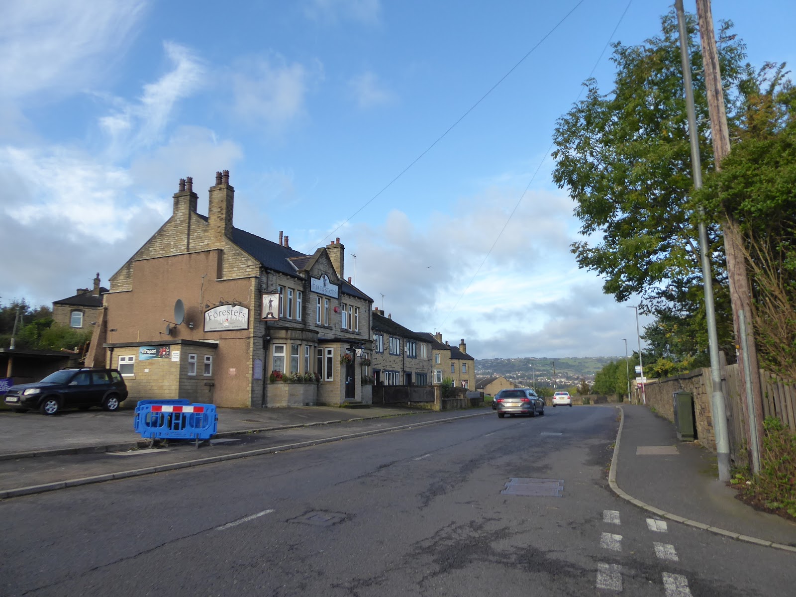 |
| The Foresters inn, Park Road West, Crosland Moor. |
 |
| Milnsbridge from Whiteley Street. |
 |
| The Royal Inn, Scar Lane, Milnsbridge. |
It seems that this country lane was never widened as urbanisation took hold of it, meaning that the footway frequently disappears from one side as we head up past the strings of terraces that cling to the south side of the lane, and also the Milnsbridge goods yard site that would be a fine location to revive a station on the Colne Valley line (hint hint), rising to get a good elevated view upstream when we need to cross over the railway as it passes below us and we carry on uphill, past the filling station and the many semis that have their back gardens terminated abruptly by the scar edge. Enter Golcar proper as the suburbs switches for 1950s to late Victorian again, getting another valley view as the high lanes separate and we carry on up the highest, Knowl Lane, which leads us up past the Providence Methodist church and and various old schools before we come around past the whitewashed Rose & Crown inn, a useful visual indicator of the hilltop's approach when riding the bus uphill, and thus we meet the view that greeted the start of the Colne Valley Circular, with the sight beyond the cottage rooftops down to Linthwaite and up to Bolster Moor making a lot more sense this time around. Past the spired St John's church and the Colne Valley museum we go as we join Town End, the village heart where both rural feeling cottages and boutique shopping endure by the village Co-op and War Memorial, and a route could be continued up to Scapegoat Hill from here, looming to the northwest, but we have an eastwards tack to resume, among the cottages and terraces around the Rising Sun at the head of Leymoor Road, which leads us back towards the Circular path that we had intended to walk. We pass through the hamlet of Leymoor as we go, its old weavers cottages being distinct among the later phases of suburban growth that have arrived around it, filling in the previously empty fields of Golcar Flat, as the lane descends to Leymoor Bottom, where we pass the Percy Vear's Old Cask inn and then almost slip downhill on the tree-shaded passage down to Benn Lane, at the bottom of the side valley of Longwood Beck, where greenery coats the bank to the north, concealing the fact that a mill site occupied it a century ago. An ascent soon comes, up Church Street, below nicely located cottages that have the tower of St Mark's church looming dramatically behind them, which leads us up to the Longwood War Memorial at the side of Longwood Gate, where we cross to meet route we'd intended to travel again, seeking the path that squeezes between the cottages of Thornhill and then hits a rough and stepped ascent up the face of the Nab End cliff, passing a concrete terrace that has its view obscured by trees, before we reach the viewpoint above.
 |
| The Colne Valley and its railway line |
 |
| Providence Church, Knowl Road, Golcar. |
 |
| St John's church, Golcar. |
 |
| Weavers Cottages, Leymoor Road, Leymoor. |
 |
| St Mark's church and Church Street, Longwood. |
A bald top above the Colne Valley would provide an excellent panorama, but the presence of the Longwood Tower enhances the promontory even more, and a trip up it spiral staircase to its top gives us a view that makes the trip, giving us a view from Castle Hill in the east, over the Crosland Moor upland opposite and upstream to the mass of Meltham Moor in the west, with views down to Milnsbridge and Golcar just to add that extra bit of visual spiciness, a great place to be in the Autumn sunshine and a place to certainly linger if the breeze wasn't so fierce. We'll seek somewhere more sheltered to take elevenses, descending back to the ground and aiming a path around the quarry to the north, completely uncertain if this sticky path into the tree cover up Ballroyd Clough is the correct way to go until we meet the firmer path at its base, which we follow up the valley with the sound of its culverted beck burbling from under the ground, until we meet the enclosed path that leads up its eastern side, rising us up between high walls to meet Quarmby Road and the edge its eponymous and formerly rural hamlet. Urbanisation has naturally arrived up here, and Oakes Road leads us up between a suburban front and an estate edge before we encounter some formerly rural outliers just shy of the A640 New Hey Road, which cuts a broad path to the northwest whilst we track northwards, with the vast complex of Wellington Mills sitting to the west as we press along past the Methodist chapel and the very derelict old school building along the continuing lane. Pass some new commercial buildings created in as sympathetic historical style as I've ever seen before we pass between the redeveloped Plover Mills site and the concealed Low Hills park, before Plover Lane drops us on the main corner in Lindley, by the prominent clock tower and St Stephen's church, where a scarecrow festival seems to be in business (which would explain the life-size Woody from Toy Story outside the Sainsbury's Local, which one little dog is taking vocal objection to), and it's here we break for elevenses, on the benches by the side of Acre Road, next to the Black Horse Inn and the Liberal Club. We get onto our eastward push, down Daisy Lea Lane, which is where our previous trip through northern Huddersfield brought us, five years ago to the day, as it happens, and so steps are retraced for a bit, down past the recreation ground, and along the private and swanky stretch of the lane that is still fenced and gated off to discourage visitors, and this leads down to the A629 Halifax Road, which we cross to find the footpath behind the back gardens that leads over to Birkby Road, which deals us pleasant greenery and marshiness underfoot in equal measure.
 |
| Longwood Tower. |
 |
| Ballroyd Clough. |
 |
| Wellington Mills, New Hey Road. |
 |
| St Stephen's church and the Lindley Clock Tower. |
 |
| The Halifax Road - Birkby Road footpath. |
Landing on Birkby Road, it's immediately striking how Grimescar Wood looms over the suburban spread to the north of the town, and the feel of the lane suggest that this is as far as the Edwardian town spread, as everything to the north looks distinctly mid 20th centurry, and the houses to the south are suggestive of being retreats from the industrial town with Rose Hill Manor (with its contemporary cafe and natural burial ground) and Birkby Grange both looking the part as they flank the Birkby Rosehill cricket field and the Huddersfield BUPA hospital. Terraces return to the roadside as we come down to Wheathouse Road corner, and they present a bunch of interesting faces as we progress up the road beyond, before it bisects Norman Park, for yet more leafy accompaniment as we rise to meet Halifax Old Road, beyond which we enter Fartown, pressing though the suburbia of a century-plus ago along Spaines Road, which leads us by Huddersfield's major cricket ground, where Yorkshire CCC might play an occasional game, and the Hirst-Haigh-Rhodes memorial by the roadside is so large it could easily be mistaken for a cenotaph. This probably marks our closest pass to the centre of town here, barely a mile distant from here, and we can consider our trip to be entering east Huddersfield as we cross the directly northbound A641 Bradford Road, the other dual carriageway out of town to the wider world, and Fartown Green Road continues its way among the terraced throng before we hit the steep rise up Woodhouse Hill, and just when we'd started to forget that Huddersfield is a town on many hills after pacing a relatively easy going path for the last hour or so. It's pretty clear that this vantage point was another one favoured for the construction of out of town villas in the 19th century, where the hillside below the spired Christ Church offers a fine view over the town centre, and the remnants of a older settlement sit at the hill top, between the spread of the Sheepridge and Riddings estates to either side of the road, where rural cottages and town villas mix it up, and Our Lady of Lourdes RC church looks like its dwelling in a converted cinema. Crest the hill, the Sheep Ridge as I'd assume it, and start town in towards Deighton, getting sight of Dalton Bank as it looms large at the eastern end of the town, and getting a look downstream on the lower Calder valley for the first time in a while, with Gawthorpe water tower and Ossett parish church briefly returned to the horizon, before we come down past the Working Men's club and meet the path we blazed away from this corner back in May, and thus descend to pass over the Birkby-Bradley greenway and the railway at Deighton station, which would have made an equally viable jump-off point for the town circular excursion if we'd wished it.
 |
| Birkby Grange, Birkby. |
 |
| Fartown Cricket Ground and the 'Great Triumvirate' memorial. |
 |
| Woodhouse Hill. |

 |
| Descending into Deighton, with Dalton Bank beyond. |
It's a short walk down Whitacre Street from there, past the terrace of Railway cottages to land on Leeds Road, which needs to be paces only a few steps northwards to meet the abutments of the missing bridge of the former L&NWR Kirkburton branch, which a rather sticky footpath follows the edge of the embankment of which, away from the A62 and down to the footbridge over the Huddersfield Broad Canal, in the shadow of the looming Whitacre Mill viaduct, which reaches its six broad spans over both canal and Colne, while still awaiting useful redemption since the last trains crossed it in 1971. We pass below it to start our southbound push and meet Ashgrove Road, leading its lonely industrial path up to the sewage farm beyond the town, and a peel off from here leads us to the path around the concrete boundary wall that encloses the Dalton Chemical Works, and the extent of its site can be felt as we pace between it and the banks of the Colne, spying the extensive complex of pipework, buildings and chimneys that stretch down the site, crossing the river (as do we) down to the spur of railway that once served it, the footbridge over which we cross to meet the side of the branch line once more. The path here leads up to Dalton Bank Road, where the railway's under-bridge is still intact, and the alignment of the railway is traceable as it sneaks behind the outlying houses on Nettleton Road at the eastern edge of suburban Dalton, with bridge parapets visible with a short detour up Jagger Lane, and once beyond the boundary of the plant (and its terrible scents in the air), we pass into the full bore of suburbia along Sutton Lane and seek more substantial abutments enduring further along a trip up Newland Road. We then land on Crossley Road again, and take another trip across the Minerva Works site, but instead of taking a path into Kirkheaton, we make a left turn to continue our way around the town, following Albany Road as it leads us to a passage over Ox Field Beck before we turn onto Waterloo Road to pass through a suburban enclave that developed on a low field surrounded by banks of enduring woodlands, which seems to be a common pattern of residential development around this town, regardless of which portion you find yourself in. Pass over Lane Head beck, the northernmost stretch of the minor river that started life as Shepley Dike, and rise with the lane up to the division point of the Wakefield and Penistone Roads by the Waterloo Tavern, where getting to the side of the A629 is a harder challenge than it ought to be, and we can continue south between the Morrisons superstore and the face of the Waterloo estate, with the early afternoon sun landing a rare burst of almost balmy heat upon us.
 |
| Whitacre Mill viaduct and the Huddersfield Broad Canal. |
 |
| Dalton Chemical Works. |
 |
| Dalton Bank Road bridge on the Kirkburton Branch. |
 |
| Minerva Works, Crossley Lane, again. |
 |
| Waterloo Corner. |
That's probably the last burst of outdoor warmth that this walking year will provide for us, so we will make the most of it as we come past the bungalows on the bank above the lane and the semis in the depression below it, to find the turn up Southfield Road, only a short way north of Fenay Bridge, where the climb to the west is just a surprising as we cut into the southern edge of the Greenside estate, which is amazingly the first stretch of council housing that we've met up close on our tour of a town that has down much to demonstrate its green and leafy credentials, of which even more are seen as we press on uphill past Fernside Park. It's a climb and a half among whitewashed and stuccoed houses to land in Almondbury by the WMC, and finally rise up to Northgate to take a second look at Huddersfield's best urban village, taking the walk southwards along the opposite side of the lane, in front of the parades of terraces to get a better lit perspective on the old Rose & Crown inn, the blue police box that's almost a Tardis, while taking in the broad historical flavour of the years of local weaving, and contemporary boutique shopping, as we head down to the corner by All Hallows church. The benches by the War Memorial offer themselves as a spot for a late lunch, and we resume the westwards track of the day by heading up Westgate, where the Conservative club occupies probably the oldest building in the village, and the pubs the Woolpack and the Radcliffe Arms both still do business as we push away among what used to be the rural face of Almondbury, before suburbia landed in it and stretched its way along Kaye Lane, giving you the feeling that you are at the heart of a mid 20th century estate, rather than on a single ribbon of houses with open fields on either side. Only when the lane dips to pass the Wesleyan Cricket club do you get the open perspective that draws your eyes over Huddersfield, revealing the true nature of the landscape, where the formerly rural outliers almost formed a hamlet of their own and the declining Longley Lane would invite a route back towards town, remotely revealing the view over the Colne valley as we hit the next crest, with the bulk of Huddersfield Royal Infirmary prominent on the distant hillside, and having hidden well from our gaze when we were much closer to it early today. My plans had been to hit the home stretch from here, but our proximity to Castle Hill makes visiting it a small necessity as it is the best viewpoint in the vicinity, and so we carry on up Ashes Lane, which offers a fine evolving panorama over Huddersfield as we go, which challenges us to observe the route that we took across the north of the town, while ascending uphill from the Gledhill Hill corner up to the Castle Hill Bottom farm, where we turn to visit our favourite hillfort again.
 |
| Fernside Park, Southfield Road. |
 |
| Northgate, with Tardis, Almondbury. |
 |
| The Conservative Club and the Woolpack, Westgate, Almondbury. |
 |
| Rural Cottages, Kaye Lane. |
 |
| The Longley Estate and Huddersfield, from Ashes Lane. |
This second detour is probably going to make this trip the last long excursion of the year, despite having promised that for last weekend, but it's a trip worth doing, heading up the steep path up the north end of Castle Hill to rise the 30+m up from the road to land on the rampart of outer bailey of the fort, where the rising edges frame the Victoria Tower almost perfectly, and we'll pace the whole way around the top of the ditch to give a short victory lap for all the territory that we've seen this year, with pretty much everything in three directions having fallen beneath my feet in 2019. Pause for a late watering before we have to aim down, cursing the fact that I've not got a large enough time window to get up the tower whilst it's actually open for visitors, and I'm not going to linger up here longer than necessary as the days sunshine is fading rapidly, and thus we head down the way we came up, hitting the further descent down High Lane from five years prior, past the converted reservoir house and the Hall Bower school and entering another suburban ribbon of houses at the towns fringe, which feels far too narrow for modern traffic, down to the Victoria inn, where we turn to a fresh path on Jackroyd Lane, where the theme continues. Soon enough we're back in suburban Huddersfield in the heart of Newsome, landing by St John the Evangelist's church by the Newsome Road crossing, and our path takes past the village shopping parade and the sightlines to the Newsome Mills clock tower, which has lost most of its attached buildings since seen in 2014, and then we hit the top of Lockwood Scar, the steep road that will descend us into the Holme valley, where care taken against the steepness needs to measured against the need to keep a move on. So it's a downhill hurry, among three distinct steps on the lane, through semis, terraces and the remnants of industry (without getting any useful sight of the circular Ridge Close apartment building that sits so obviously on modern maps), to land on the A616 Woodhead Road by the Lockwood inn, and bottoming out the descent as we cross over the Holme via the Bridge Street bridge, and come up to Lockwood Bar by the out of time shopping parade and the Baptist Chapel. Over the Meltham Road junction, the final press of the day is uphill, on the rising Swan Lane, passing the ice cream parlour that is doing good business despite the shifting season, and also the Swan Inn, opposite the group of lower tower blocks that sit to the south of the railway line, which themselves form a rare site in this very low-rise town, and we pass under those metals to emerge into the presence of the Prospect Ironworks once more to ascend the steps to Lockwood station once again, sealing the circuit and wrapping the day comfortably ahead of the train at just shy of 3.40pm.
 |
| Castle Hill ramparts and the Victoria Tower. |
 |
| Hall Bower School, High Lane. |
 |
| Newsome Mills Clock Tower. |
 |
| The Lockwood, Woodhead Road. |
 |
| Swan Lane, Lockwood. |
5,000 Miles Cumulative Total: 4228.1 miles
2019 Total: 577.7 miles
Up Country Total: 3765.1 miles
Solo Total: 3913.9 miles
Miles in My 40s: 2821.9 miles
Next Up: Holme to Calder, via a supposedly 'short' walking route.
No comments:
Post a Comment