15.2 miles, via Newall Carr, Weston Moor, Askwith Moor, Beecroft Woods, Blubberhouses,
Stonehouse Crossroads, Padside, Braithwaite, Heyshaw Moor, Nought Moor, Bewerley,
and Bridgehouse Gate.
With phase one of the Summer's walking plans done, having covered all the immediately obvious trails in the Wharfedale - Washburn - Harrogate bracket, it's now time to move on to the second phase and to press on to the north, and to overcome the idea that a great and seemingly insurmountable distance in the mind is actually a lot less than that which is measured on the ground, finally providing an answer to the thought, that has tested me for several years 'Does One simply walk into Nidderdale?'. The only way to find out is by attempting to walk it, and thus four fresh trails are put on the slate to breech the emotional distance between Wharfedale and Nidderdale, and our first plan has us riding out to Otley to set course for the heart of that distant valley, over the moors and dales, getting off the bus at 9.15am with another route to blaze through the town to get over the Wharfe at Otley Bridge. So away we go, under gloomy skies, up Crossgate and over Boroughgate to the long stone terraces of Wesley Street, North Parade and Manor Street, passing the spires of the United Reformed church and former board school, to meet the riverside in the narrow greenspace of Tittybottle Park (no sniggering at the back), noting that the Wharfe seems higher than usual, or at least that bit less placid, before striking north again over that many arched bridge and setting off up Billiams Hill to retrace steps previously made through Newall Carr last year. An ascent does bring on a somewhat differnet feel to the walk, noting the consumed grounds of Newhall Hall this time around, as well as noting the old sign set into local walls, hammering on past the old and new Wharfedale hospitals, still unvisited in all my years working for LTHT and wondering if Otley's suburbia grew to meet the edges of West Yorkshire or if the border was placed where it is to contain it. Countryside arrives with North Yorkshire and all the views come to the west as the bulk of Rombalds Moor rises and reveals itself, as we push on past the Copmanroyd terrace and Clifton's village hall, nowhere near the actual village, and find that Nidderdale's AONB is only 35 minutes out from our start and we could claim an early success in our quest and go home if we were feeling cheeky, but we have a real mission to accomplish as we press on up the hill on the welcome footway to pass the Roebuck inn and to meet Clifton Lane and our sentinel friend, the Clifton Moor mast.
 |
| Otley United Reformed Church, and former Board School. |
 |
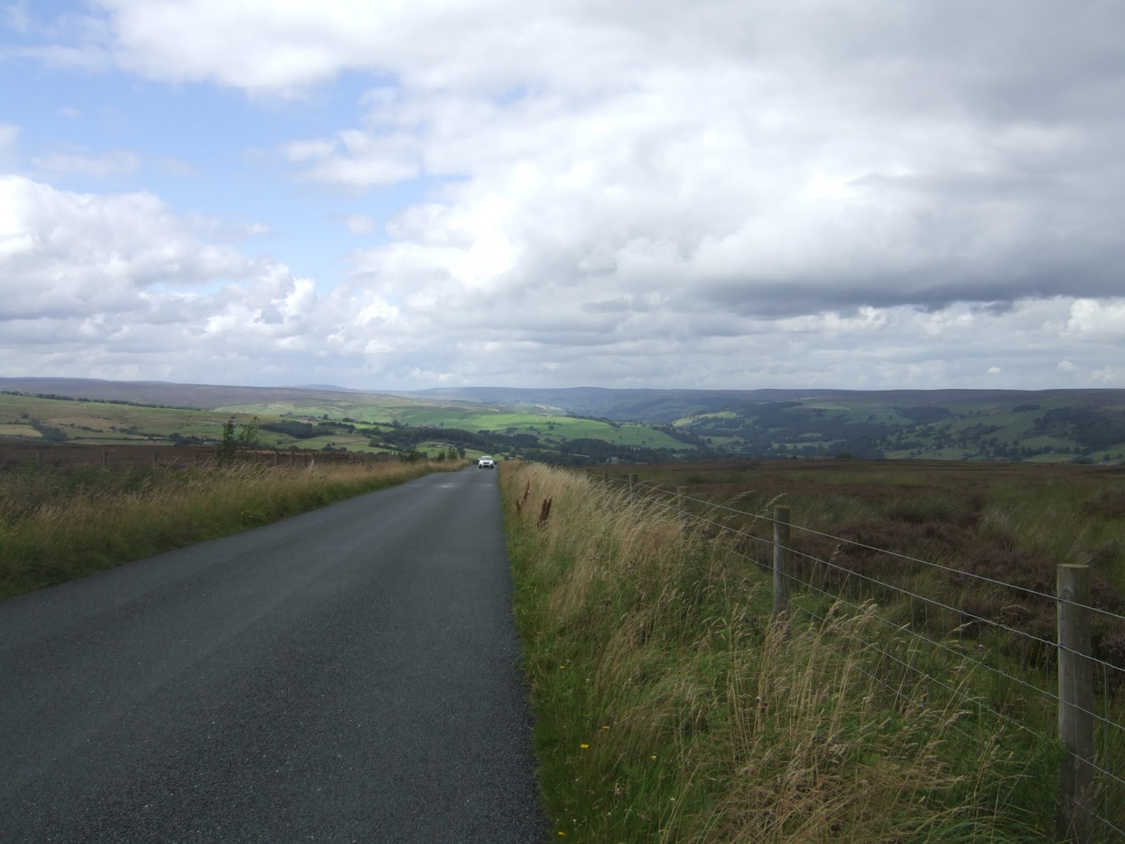
| Rombalds Moor from Newall Carr Road. |
 |
| Clifton Moor mast. |
It's road walking all the way on the remaining ascent to Weston Moor, and we already know that the road walking up to West Carr farm is no fun at all, with a nasty enclosed section, a blind summit and a blind corner coming in short order, before rising on along a long loop in the road to the junction down to Dob Park, and up north-westerly to the moorland, getting some elevated reveals down Wharfedale, across the Washburn and down to Almscliffe Crags before we rise to pass among the rough grasses. A panoramic view soon comes on, revealing about as much of Lower Wharfedale as can be seen from a single perspective, but also giving us a Nidderdale reveal way earlier than could be expected, as Brimham Moor and Menwith Hill peek out from behind Norwood Edge, and once we've reached the crest of the moor, about 270m up, we get a clear sight across all of the moors above the Wharfe as far as Beamsley Beacon, and also looking back for a view straight through the Aire-Wharfe gap. Sadly, the ominous clouds bring on rain that was not fully anticipated, and so as we transition past the end of Moor Road, coming up from Askwith, we have to don the waterproofs for making our passage on the road across Askwith Moor, and thus the shading of the moors is a lot less appealing than the last time we came here, so just as well the views across Snowden Carr to the Washburn have already been recorded on a brighter day than this. The road shifts due north and we lose our view to the south and west, as the heather clad 300m summit of Askwith moor rises to our left, but the Washburn still keeps us company as we take in the very sharp end of the Sword Point ridge, and note Swinsty Reservoir looking a lot greyer than usual, finally gaining some relief from the wind and rain as it eases back after we've paused to observe a roadside memorial to two motorcyclists who were killed in a accident at the road's 280m summit. Then we descend, away from the heather and bracken to the moorland fringe, getting our view to Denton Moor and beyond back, and down to the edge of the viable farming lands, where a number of farms loiter close to roadside as it sweeps around hugging the contour around the watershed of Dick's Beck, not forming a hamlet of any kind, though the map call the area High Snowden. Looking back, the moorland takes on a familiar profile, and the house and farmstead to the north look recognisable too, as we were here only a week ago, and we rise to meet Four Lane Ends on the crest of the ridge that splits the halves of the Washburn, and even after a month of extending our field of walking experience to the north, we now have a good eight miles of virgin territory to traverse on our way to Nidderdale.
 |
| Weston Moor. |
 |
| Askwith Moor. |
 |
| Off Askwith Moor and on to Washburn and Nidd. |
 |
| Prospect House farm, and its Prospect. |
It's a downhill decline to start with, losing quite a lot of height down Rues Lane, getting the feeling that the day is going to try its best to get sunny again, but the cloud cover is going to remain implacable and thus it'll be mostly be grey and only half bright as the day progresses, and the wind isn't feeling any too friendly, so the waterproofs are probably going to stay on for the remainder as they are the most effective windcheaters that I own. The mass of Timble Ings dominates the view to the west, with the high moors above Wharfedale beyond, and also a sightline to a familiar looking shape that I know sits above Nidderdale, but isn't one that an identity can be put on at this juncture, and looking to the east ought to reveal more of Fewston Reservoir, barely peeking out through the plantation that surrounds it, so note is taken of RAF Menwith Hill instead, relatively close but retreating from view for the time being. Past Rues farm, we soon descend to the boundary of Beecroft Woods, where the Grange farm is prominently located and Yorkshire Water offer more paths around their reservoir estate, and we drop down through the trees to the rather awkward crossing of Thackray Beck before sharply ascending away again, along Shepherds Hill past Anchor Farm, and into open fields again, giving us a much better profile of Fewston Reservoir in its wooded cleft and gradually rising to get sight of the moors between Wharfe and Washburn again, with the scattered farmsteads of Blubberhouses before them. The main bulk of Blubberhouses Moor manages to hide from view beyond its grassy periphery, and we descend, to make our Washburn crossing at the top of the reservoir, with the A59 making its passage at the edge of the part of North Yorkshire that can reasonably be considered local, making the sharp drop to see Blubberhouses Hall across the way, and to arrive by St Andrews church on the road junction, incorrectly identified as ancient when seen in 2003 but actually very Victorian. This is the limit of territory previously walked from home, from way back when walking was strictly for bank holidays only, with the Upper Washburn reservoirs still awaiting their day (having been plotted more than a year ago), and the unknown awaits beyond the channel of the river and the A59, once we can get across it, as we rise away from this wonderfully named hamlet, rising swiftly below the tree cover on Hardisty Hill and getting a reveal above Skaife Hall farm of the Harrogate - Skipton road cutting its path through Kex Gill to create one of the most dramatically situated trunk roads this side of the A66 across Stainmore.
 |
| Beecroft Wood and Grange farm. |
 |
| Fewston Reservoir. |
 |
| St Andrew's church, Blubberhouses. |
 |
| Kex Gill and the wooded Upper Washburn. |
Admittedly, this terrain isn't quite as unknown as I might pretend it is, having been driven this way on the way back from Nidderdale in the spring, but it's pretty much being approached with fresh eyes as we regain the altitude lost when making our river crossing at Blubberhouses, as we ascend to around 100m above the Washburn, tracing its deep channel as it flows down from Thruscross reservoir and looking out across to the expanse of Rocking Moor to the west, with Brandrith Crags showing up as an engaging looking outcrop. Even as we push up to moorland elevation again, we don't feel the isolation met in some of the nearby locales, as scatterings of farmsteads and cottages dwell on the rising land to the east, the edge of the viable farmland in this area, with a few looking rather substantial for such marginal land, and the local business seems to be prospering too as we pass the Mackenzie's Yorkshire Smokehouse, an ideal spot to pause and load the bag with meaty goodies if it wasn't for the miles yet to come. Views to the west enhance further, and the remaining moorland between Wharfe and Washburn must be considered for the 2018 season, rising beyond the wooded valley of the river, and once past the ancient road sign at the Meagill Lane corner and above the 250m elevation we get moorland coming right up to the roadside as signs of civilisation pass away from view, and we'll slip onto the edge of Hanging Moor to take lunch, as the ladder stile is the only available seat for miles around. The moor rises above the road, clad in purple heather as we pass the ends of Menwith Hill Road and My Love Lane (?), cresting at about 280m elevation, which gives us numerous revelations around the horizon, as a look east will shop up the domes of RAF Menwith Hill and a view down Lower Nidderdale, whilst to the west we get the view across to Simon's Seat and the distant lump that can now be identified as Cold Stones, and the centre shows up Brimham Moor and the way to come over Heyshaw Moor. The nearest feature is the last to be seen, as Thruscross Reservoir appears below, its size well concealed by the folds of the landscape and the surrounding fringe of trees, and our attention can then shift to Stonehouse Crossroads, where suburban dwellings sit at moorland altitude next to the pub on the roadside corner, with its water tower rising above it, a curious setting that for sure, and it doesn't look like the pub is doing much business at the moment, which is a shame, and marks our departing point from Greenhow Hill Road and set course on the minor roads for the heart of Nidderdale.
 |
| Woods and Moorland surround Thruscross Reservoir. |
 |
| Hanging Moor. |
 |
| To the East, Lower Nidderdale and Menwith Hill. |
 |
| Stonehouse Crossroads, suburbia on the moors. |
Harper Lane starts its tree lined descent into the wide catchment of Darley Beck, the Nidd's major southern tributary, reveling that fact the we can feel close to a familiar territory already as the mast at Guise Cliff appears above the mass of Heyshaw moor, and a look east reveals the craggy hillside above Thornthwaite as we descend among the fields to the cross roads that turns us towards Padside, barely qualifying as a hamlet, but certainly a distinct collection of farms and cottages sheltering below the high moor edge. It's lovely little spot, a fine country getaway with a very quiet lane running through it, beyond which we descend to make our passage across Darley Beck, at about 210m up, and hit the rising lane to regain some of the altitude lost and to start checking the distances remaining to get to Pateley Bridge, and start to believe that getting this trip down within a 6 hour window could be possible as we have less than 4 miles to go. Hammer on uphill, to pass Dacre Braithwaite CofE Primary School, one of those really remote country schools that is distant form everywhere, even the tiny hamlets that it serves, and picking Braithwaite out of this landscape is a good challenge as the mind has to associate all the scattered farmsteads and houses around Foldshaw Lane into a single settlement. Rising beyond Woodmanwray Lane we return to moorland altitude, and the views reveal themselves once again as we make our passage onto Heyshaw Moor, and we get a 270 degree panorama that is completely unexpected, as we can look back towards Stainburn Forest and Blubberhouses Moor, with the viewpoint on Lippersley Ridge clear and prominent, and even back to the ridges of Rombalds Moor and the Chevin. To the east the view can be had down to the Lower Nidd and all the way to Harrogate and across the Vale of York with the distant Moors and Wolds beyond, and whilst the western view across Braithwaite Moor is the least interesting, we get our third appearance of Cold Stones and the rise of Greenhow Hill, as we press on, finally at a 300+m altitude to meet the Dike Lane junction and the high route over Heyshaw Moor, rising steadily to the lane's summit at over 330m up, and getting the sudden appearance of Guise Cliff mast and the rise of Brimham Moor above the folds of mid-Nidderdale. Set course forwards as the lane starts to decline, giving us the reveal of Upper Nidderdale, a view which is surely one of the best of the year, pressing on among the heather to the Heyshaw - Nought Moor wall, just to the west of Yorke's Folly and even if this is a place already seen, this revelation still feels wholly new as the seemingly distant Nidderdale is drawn securely into my field of walking experience.
 |
| Padside, a scattered hamlet, if there ever was one. |
 |
| Braithwaite, an even more scattered hamlet. |
 |
| Across Heyshaw Moor to Guise Cliff mast and Mid-Nidderdale. |
 |
| Off Heyshaw Moor and the way to Upper Nidderdale. |
Hitting a familiar corner, we can eschew the descent down Nought Bank Road, not fancying the twisty corners and sharp declines in the face of the traffic, instead joining the route of the Nidderdale Way to walk off the moor in the direction of Skrikes Wood, with a lot more bracken on the ground than there was before, but even with it reaching armpit height in places, the way downhill is a lot more obvious than when ascending, as we slip down through the tree cover to get the reveal of Pateley Bridge across the valley as we re-emerge. The field descent is also a lot easier than the ascent, giving us a clear route down as we lose 100m of elevation from the moor edge in pretty short order, finding that these local cows are completely unmoved by having a wanderer in their enclosure, and we can look downstream to this year's holiday base at Bewerley Hall farm before we rejoin the road and pace our way carefully down to Turner Bridge, where Fosse Gill is charging like a mountain stream. Turn left to retrace steps through Bewerley village, not looking quite so good under greyer skies, but I'll still admire it and stick my head into the Grange Chapel and ponder the wisdom of retiring to the upscale bungalows that have grown in this corner of the valley. Depart the path previously traced to join the road well-ridden into Bridgehouse Gate, passing above the Nidderdale Cattle market and the underused expanse of Bewerley Park to meet the road up to Grassington, and descend past the Royal Oak and the parade of shops and delis that could easily sustain your eating need when holidaying in this chainstore-free corner of the world, and start to meet the unexpected crowds as we pass the Wath road and the Memorial Park. It seems that Pateley Bridge is having a 1940s weekend, which means there's a lot of folk out in military garb and period dress on the streets as we cross over the Nidd Bridge to knit the two halves of the Nidderdale Way together and to get the trek down in the 6 hour window I'd hoped for, but the tourist crowds completely scupper whatever refreshment plans I might have had, as there will be no seats to be had in any pub or café. So a bonus loop can be had up Church Street to take a closer look as the austerely Victorian St Cuthbert's and to then descend past the former workhouse and CofE school on King Street find the bus stop at the bottom, concluding the day at 3.20pm and joining the long queue for the #24 bus (which can get completely filled whilst only taking five fare paying passengers among all the oldsters), and I know that a very long ride home is still to come, but the feeling of satisfaction that is taken away is huge, as we haven't just put down 15 miles today, we have really
travelled.
 |
| Pateley Bridge revealed from Skrikes Wood. |
 |
| Bewerley village. |
 |
| Bridgehouse Gate. |
 |
| CofE school, the former workhouse and St Cuthbert's, Pateley Bridge. |
5,000 Miles Cumulative Total: 2921.7 miles 2017 Total: 356.7 miles
Up Country Total: 2662.2 miles
Solo Total: 2665.4 miles
Next Up: From Wharfe to Nidd again, with added Radomes!


No comments:
Post a Comment