11.5 miles, via Machpelah, Birchcliffe, Wadsworth Lanes, Height Road, Foster Clough,
Han Royd Bank, Midgley, Thorny Lane, Dry Carr, Luddenden Dean, Low Bridge,
Throstle Bower, Saltonstall, Caty Well Bridge, Crossroads Inn, Mount Tabor, Dodgson Wood,
Pellon, Mount Pleasant, Cross Fields, and the Piece Hall.
It's probably been observed here before, but when the clocks change, it's possible to trick yourself into an early start on Sunday morning as your body is yet to re-tune itself to the hour gained with the resumption of GMT, and this is particularly useful when your Saturday washes out and a much, much brighter day is projected to follow it, so getting ahead of the limited services to Calderdale means that you can be alighting the 9.20am train at Hebden Bridge without having broken you weekend sleep patterns, and all sorts of prepared for a turn along the north side of the Calder valley for a change. What you aren't ready for is the hiss of rain that passes over as you start out, weather that ought to be expected at this time of year, in this location but still catches you out as you pick an alternate route out to the A646 Burnley Road, via Mayroyd Lane and Crow Nest bridge over the Calder and up through the yard of reclaimed stone to still pass over the Rochdale Canal on the Station Road bridge, ahead of rising past the smart terraces and villas at the Machpelah corner and elevating with the A6033 Commercial Road. We've a lot of climbing to do to get onto our high downstream route, and thus we join Birchcliffe Road as it presses forcefully uphill, through an accumulation of proud terraces that still have me wondering just how this town grew around the merging rivers and up the steep valley sides in the 19th century, as we head up past the Stubbings school and up to the apex corner, then passing the hostel and school in th old Baptist chapel and rising sharply on as the weather blows itself out and sunshine pours in over the lower wooded reaches of Hebden Water, with St Thomas the Apostle's tower in Heptonstall rising above it. We rise with Wadsworth Lane to what feels like the top of the town, only to find a block of council houses on the high apron of fields above it, as if there wasn't anywhere else to place them, which we rise on past, with the valley view expanding behind us in the sunshine, revealing the path to the south that we took down into the town a few weeks back, as we also cross our last previous path in the vicinity, blazed in 2013 and revealing that the north side of Calderdale is still wanting for attention, even now. Shift away from having the sunshine directly in our eyes and roll uphill among the farmsteads that occupy the lane below the high road and the moorland apron, a cluster that seems to be growing into another suburban sort of hamlet, which I'm calling Wadsworth Lanes, high over the valley, from where we can look up the valley of Hebden Water to the north to spy the Old Town Mill on its high perch, while also rising high enough to spy all the wooded branches of the Calder splitting off the valley below and to look across to Stoodley Pike rising above the moorland brow to the south, revealing why people might want to reside up here, despite the practical inconveniences.
 |
Hebden Bridge market place, with unseasonal(?) rain.
|
 |
Sunshine returns, illuminating Heptonstall church.
|
 |
Old Town Mill, high over Hebden Bridge.
|
 |
The Calder valley, around Hebden Bridge, with Stoodley Pike beyond
|
Land on Height Road by the Mount Skip Golf course club house, a lane which will carry us east into the glare of the autumnal sunshine and the teeth of the stiff breeze that chills down all the radiant benefits of the clear skies, and as we undulate on, we already find ourselves closer to Mytholmroyd than Hebden Bridge, as there is barely a mile between the pair of them, while we press on above the steeply declining valley side, unsure if we are on the edge of moorland altitude or whether the golf course forms the barrier between us and it. On the high side, the lane has to traverse itself around the cloughs which run off the moors above, forming quite a broad detour to get around the piddly little stream of Hill House clough, as we come around the the views of looking directly up Cragg Vale, one of those views that has you wishing that the sun in the sky could be moved to provide illumination from the north, dropping Manshead Hill and Blackstone Edge on the southern horizon as we again admire and analyse the landscape of the town below, with the railway line obviously bisecting it. Get forward views to the fringe of Midgley Moor as we press on, passing the microwave mast at the laneside and the only couple of rural cottage outliers still enduring before we make the turn to pass around Foster clough, a stream that we have paced up from the town on a New Year stroll, but not high enough to discover that it has a hamlet at its crossing point, crammed in on tiny plots and partially concealed by tree cover, and not directly accessible from below, rendering it a bit of a curiosity, making you wonder if it once served the Delphs quarries above. Keeping on east, we lose views for a while as woods of Han Royd Bank rise to coat the roadside, giving us more of the autumnal colour we crave as we pass around the eponymous farmsteads above, with the view that emerges beyond revealing that we are now a good step of twelve beyond Mytholmroyd, with Scout Woods also falling behind us, while we look ahead to the downstream run of the valley towards Sowerby Bridge, tracing road and rails more easily than the river, while ahead lies the rise of the far side of Luddenden Dean, where our path is inevitably leading. We do have a proper village to traverse before we get there though, namely Midgley, which names both moorland and lanes in the vicinity, and forms quite a bold spot on this hillside, showing up vintage along Towngate from the Methodist chapel to the Great House farmstead, making itself look as pleasing as possible in the sunshine, while being still contemporaneously active to have attracted a small council estate beyond, as well as a village store in its old Co-op, though none of its three pubs seem to be in business anymore.
 |
Height Road and Hill House Clough.
|
 |
Mytholmroyd and the view up Cragg Vale.
|
 |
Foster Clough and the quarry delphs.
|
 |
The downstream Calder valley beyond Han Royd Wood.
|
 |
Town Gate's terrace with a view, Midgley
|
The Lydgate corner gives us our choice of route, and as we've already said, we'll take the rising track of Thorney Lane as it splits off to the northwest, starting our venture into Luddenden Dean, not the sort of wander than I'd usually engineer, but this valley doesn't lend itself to straightforward visits, and as we rise among the farmsteads in the lower reaches, we also encounter terraces which seem a bit too urban for this corner of the countryside, though they were probably located to serve the Oats Royd mills, which hide below the roll of the valley side below us. Shifting northbound and passing the Gate House hamlet, we rise with the lane as we pass around the nab end of Midgley moor as it terminates the west of us, and as we rise towards High House farm, we come around to heading northwest, giving us a look across the valley angle to see Wainstalls village perched on the high far side, on the corner of Warley Moor, as we come up to the reveal of the upper valley, a view that the memory banks really needs to filter for having not been seen since the Calderdale Way brought us here in 2012. That's a route we'll match as we come down from High House Lane to Dry Carr Lane, cursing the sunshine's retreat behind fine, but opaque, high cloud causing the view up the sharply profiled and narrowing valley to be dulled over as we drop down towards the end of the metaled roads below the rough fields of Dry Carr, and note along the way, as we continue to drop down on the diminishing and shaded track to Clough Hole, that these paths are still drawing the walkers out, as if many have discovered the Great Outdoors as a place to safely associate during a pandemic. I hope that they continue to do so in the future, too, and thus my path up the valley onwards is busier and much more sociable than might have been anticipated, rolling its way upstream, on the rough and rocky track of Wood Lane as it shifts among the fields from the secluded Upper Mytholm farm to Catherine House and its stables, as the route out on the far side is mentally traced along more lanes heading back east as we head up towards the traversible limit of the valley, beyond which the aquifers of Yorkshire Water hold sway. It does turn out that water supply doesn't hold the full story of the landscape up here, as the lane drops down to a castellated gatehouse that would not be expected to be found up here, and ahead of the descent from Low Lodge to the crossing of Luddenden Brook via Low Bridge, we have top ponder a bit of history as it turns out that to the north lies the abandoned estate of Castle Carr, a Victorian pile in the Gothic fashion established in the 1860s which its owners never quite settled into, causing it to be never completed and subsequently demolished a century later, though it still has extensive parklands and a water garden that are annually accessible, to pique further the interest of the historically curious.
 |
Thorney Lane and the way into Luddenden Dean.
|
 |
The angle of the valley and the view to Wainstalls.
|
 |
Dry Carr Lane, and the Upper Valley.
|
 |
Wood Lane, and the Upper Valley.
|
 |
Low Lodge, Castle Carr.
|
On the north bank now, we have to head back down the valley, and as we rise up to Low Cottage and its farmstead at the head of Low Lane, we get the sunshine breaking though again, and as a bench presents itself by a notional bus stop that's good place to breaks for elevenses at the halfway point, ahead of us restarting our eastbound press, looking downstream to the high bank of the valley to the west of Halifax, presenting a much greener valley that the grey one we saw then, with our lane pushing up past Nunnery farm and over the Height clough cascade at the edge of Upper Hey wood. Continuing with the rise, it's fun to regard the evolving view over a landscape that you passed through barely half and hour ago, ticking off the farmsteads and looking up the southern valley side to see what you missed seeing whilst over there, as Heys Lane rises us up to the tiny hamlet of Throstle Bower, which only gets that much acclamation due to the presence of the valley's non-conformist cemetery, and it's all uphill beyond there, pushing us uphill to the next hamlet on the lane, namely Upper Saltonstall. This is again where a transit on the Calderdale Way brought eight years ago, on a path that I really struggle to recall, and at least on the traversal route, we don't get the harsh drop and climb across the valley, but we do get a cresting situation come on as we roll around the nursery that has developed quite the adventure playground in its gardens, as the decline of Saltonstall Lane drops us down towards its Lower Companion, and below some prominent quarry remains on the valley side above, as the lower valley view returns to the south of us. Frustratingly we seem to be getting more occassions of grey-overs to spoil the sunlit landscape, confirming my belief that you cannot assume the quality of the weather at any time when close to the Pennine spine, and the reasons for our descent become apparent as we drop down to meet the northern branch of Luddenden Dean, confirmong my conjecture that every side valley has at least one hidden branch of its own, and the Cat i' th' Well inn sits at the point that the lane bottoms out, with a sunlit beer garden that would be grand for trade under more predictable times than these, ahead of the turn of the lane below the shade of trees. Here Caty Well bridge crosses the steeply cascading and eponymous brook as it flows down from Wainstalls, ahead of us hitting the climb again to aim at the crest out of the valley, which draws us up past Lane Side farm, offering the upstream reverse view and the look downstream to the reveal of the Oats Royd mill complex far below, and up to the hills to the south of the Calder once again, revealing that band of resident cloud that I had predicted existed over the high uplands, as we press further up the walled and steep Wainstalls Lane.
 |
Low Lane and the downstream valley.
|
 |
The Upper Valley from Throstle Bower.
|
 |
| The downstream valley from Upper Saltonstall. |
 |
The Cat i' th' Well, Caty Well Bridge.
 | | The view back to the Dean, from Wainstalls Lane. |
|
At the top of the push to the southeast, we meet the Crossroads Inn, south of Wainstalls village, where our 2013 passage brought us on our passage over Ovenden Moor, and a right turn here takes us onto Mount Tabor Road as it forms the direct route down into Halifax, skirting the high edge northeastern edge of Luddenden Dean as it scoots past Sandy Ford farm and gives us an array of views back across this day's trail before we head up to meet the crest with the Hebble valley, spread to the north as we pass the staring benches and the playing fields on the edge of Mount Tabor. This place has already been identified as Halifax's suburban oddity in the countryside, though it's appeal is stronger on a day as bright and colourful as this one, though it does have a vintage from the times of purely rural attention in these high fields as we pass its old terraces and Methodist chapel on the run down to the crossroads, where the gold post box celebrating the 2012 achievements of Paralympian sprinter Hannah Cockroft are noted, before we continue the route into the town past the Springhead Inn. Landed on the high apron of fields above the lower branch of the Hebble, we get a fine view to the northeast of its watershed hills, from Soil Hill to Pepper Hill, which we ventured among last weekend, while also giving us a look back to the turbines on Ovendem Moor before the urban edge of Halifax is met, as Moor End Road drags us into what the signage indicates as Pellon, though the old maps name it Dodgson Wood, where the road kinks markedly to pass around another old clough. As observed before, this is a major sort of road with no obvious destination when travelling beyond the town, and it's a good idea to seek out views over the valley below as we are drawn on through the suburbia, looking over the wall in the occasional gaps between the semis to see if there's a view to be had of Wheatley Viaduct at the valley floor, which there is, if you know what you're looking for, before we drift into the landscape of council houses of New Pellon, built in stone and stretched beyond the coaching inn styled Halfway House at its bottom edge. Mount Pellon village, as was, is located just off the main road that was rebuilt to bypass it, and it's worth a short detour just to claim a tiny bit of vintage before the urban landscape completely dominates, not that we get to see all that much as the parish church sits just beyond view, and the most telling ancient feature of the Fountain Head inn is that it still advertises itself as a Samuel Webster pub, and thus the interest point has to be located where the old and new roads recombine, further to the east.
 |
Mount Tabor Road, Sandy Gate.
|
 |
| Mount Tabor chapel and Sunday school. |
 |
The Hebble Valley profile from Moor End Road.
|
 |
The suburban spread of New Pellon.
|
 |
The Fountain Head, Mount Pellon.
|
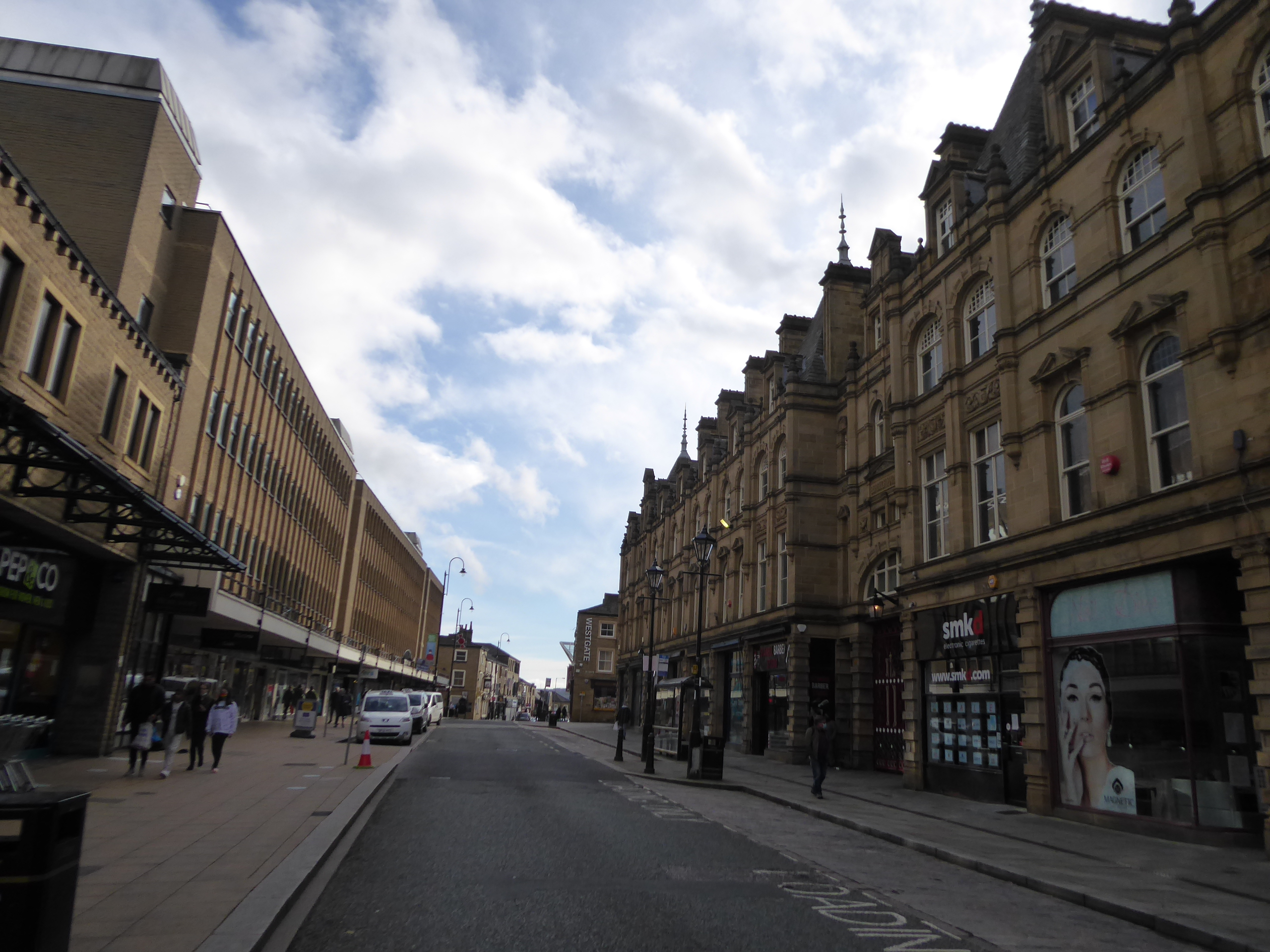
This is where the GNR and L&YR's Halifax High Level railway line ran under the road, down to the ill starred St Paul's joint station off to the south of here, a stub of line down from Holmfield that somehow endured in use from 1890 to 1960, and also escaped my close attention thanks to the twists of 2020, but still creates a feature here as we've the iron bridge parapets still in situ, with void beneath and the site of Pellon station to the south, which is accessible up close thanks to the fact that there's no one in the yard of transport containers to object to me peering through their gates on a Sunday lunchtime. Then it's back to the long run of Pellon Lane as it continues down into the town, passing among many terrace ends that would have you feeling like you were deep into an urban landscape if you couldn't see how they end off to the north on the high edge above the Hebble valley and offer a view to the looming hillsides beyond, a landscape that endures down to the passage between the various business and retail parks, ahead of the Mount Pleasant estate and the Martins Mill complex, where The Running Man inn stands (and I wonder if the staff are sick of people dropping 80's movie quotes at them?). We can also spy the spire of All Souls Haley Hill across the valley from over here, and GG Scott's best church has also avoided a closer look in this late season, too, which is an unfortunate thing to ponder as we cross over the deep cutting of the A58 Burdock Way as it bypasses the town centre, and we come down to the Broad Street corner on the older avoiding roads, landing by the Central Methodist church, and just a short way away from the town hall, as we are compelled to travel on under the roads via the subway passage that doesn't do its best to advertise its directions beyond. Guesswork lands us onto Crown Street, among the lost district of Cross Field, leading us into the town between the banks on the corner with Commercial Street and on across the top of the main shopping drag of Southgate, feeling that it ought to be quiet on a Sunday lunchtime, but it's busier than expected, indeed probaly busier than anywhere I've been since February, and thus a wary feeling take hold as we carry on among the shoppers to Market Street, passing between the Borough Market and the Woolshops Centre. Sunshine naturally invites me back to the Piece Hall as illumination was lacking during my opening week visit, and we get that, though my exit path via the library entrance isn't open today, and the crowd within is larger than I feel comfortable with, even though I can immediately see the appeal of a Sunday lunch outside on probably the last available day of the year for doing so, and thus we have to depart via the north gate, and drop down to Square Road to make our pass of the Industrial museum, the library and the chapel complex, ahead of our concluding footfalls, to close the day at 1.40pm at Halifax station, in much better time for the ride homeward than three weeks ago.
 |
| Pellon station (former) on the Halifax High Level line. |
 |
The Running Man and Martins Mills, Pellon Lane.
|
 |
Halifax Central Church, and the Broad Street corner.
|
 |
The Woolshops centre and the Borough Market, Halifax.
|
 |
The Piece Hall again, with Sunshine!
|
5,000 Miles Cumulative Total: 4710.1 miles
2020 Total: 443.6 miles
Up Country Total: 4247.1 miles
Solo Total: 4383.5 miles
5,000 in my 40s Total: 3303.9 miles
Next Up: The First Leg of My Homeward-Bound Route out of Calderdale.


No comments:
Post a Comment