10.7 miles, via Ewood Hall, Midgley, Lane Ends, Luddenden, Hollins Wood, Newlands Gate,
Norton Tower, Highroad Well, Thrum Hall, Halifax (The Gibbet, Cross Fields, North Bridge
and Charlestown), Southowram Bank, Bank Top, Withen Field, Southowram,
St Anne in the Grove, and Brookfoot.
I'd really have liked to have gotten out to Mytholmroyd during half term, but with My Good Friends having both returned to full time teaching since the summer, and the worsening Covid rates doing their best to amplify the risk factors, it just didn't seem wise to try to re-establish my Support Bubble at this stage, and thus it is rather reluctantly collapsed until the Festive Season at the earliest, but as it has been my home-from-home over this past season, it still seems sensible to use the town as my start line for my homeward bound finale, back to Morley by the shortest route possible(?). Unfortunately, the weather projection isn't looking too clever, but a Sunday option isn't there thanks to engineering works screwing everything up, ans so we alight 9.10am, feeling certainty that there will be rainfall during the trip, following the pattern of the week if we can judge by the flows of Cragg Brook, as seen from New Road, and the Calder as observed at Mytholmroyd bridge, looking far fuller than they did on any of my visits in the Spring and Summer, though still way below dangerous flood levels, obviously. In keeping with this year's theme of tracing many ups and downs, that's what we'll keep to as the last legs home are forged, starting by rising from the A646 Burnley Road and setting off up Midgley Road, past the Russell Dean store and over the Rochdale Canal via White Lee bridge, past the enduring Clog Mill, and through the band of vintage houses before we reach the elevated reach of suburbia beyond, with the sizable Calder Learning Trust in its midst as it stretches uphill, with the descending channel of Foster Clough running through it, before entering its culvert. Further up the valley side than you'd expect, we finally break into the countryside, angling ourselves to the east, looking up to the woods of Han Royd Bank, and rising carefully up to the hamlet of Ewood Hall, which seems to have retained all of the farmsteads, barns and auxiliary cottages of its estate, while managing to lose its main house, though Ewood Court appears to be for sale if you've got a lot of cash to drop, to gain a residence with views to Cragg Vale, Scout Wood and Crow Hill. That's the landscape we'll take in as we power uphill along the well-contained lane to meet Height Road and Midgley village again, which doesn't have quite the appeal seen previously on a glum day like this one, with it all feeling a bit more removed from the world, strung out at the end of a very remote bus route and feeling like a bit of harsh weather could isolate it horribly, revealing just how much the weather can affect my regard for a location, not that the residents seem to mind as they come and go along Town Gate and we press through to the Lydgate junction once again.
 |
The elevated Calder flows through Mytholmroyd.
|
 |
The suburban spread up the clime of Midgley Road.
|
 |
Ewood Court house, Ewood Hall.
|
 |
The old Co-op and the Lydgate corner, Midgley.
|
This time we take the low road, Jim Allen Lane, into the open fields that descend down into Luddenden Dean, though the stretch of Midgley village doesn't seem to have quite ended, rather it's been extended down the hillside, as we pass the isolated Spring Field terrace and then descend to the house cluster at Lane Ends, where the village school resides, ensuring there are pavements to pace as we continue to descend down Solomon Hill, still slippery with leaves as we pass the Greave house lodge and watch the local minibus service grinding its way uphill. Land on the corner where the roads split off, heading up towards Oats Royd Mills and down the valley by the viable New Road, but as we're heading down to the village a the valley bottom, we'll take our steps down Old Lane, marked as unsuitable of motors, and frankly not really suited to foot traffic as the long descent of cobbles is as slick and steep as they come, ensuring careful footfalls are made down its full length, knowing that all the height we are losing will have to be regained on the far side of the Dean as we land in Luddenden by Box House farm and the old schoolhouse conversion. Firmer surfaces take us down to St Mary's church and the War memorial, before High Street twists around to make a narrow and snaking passage past the Lord Nelson inn and among the houses at the valley floor ahead of crossing Luddenden Brook and rising to Stocks Lane, forming quite the most picturesque little enclave at the heart of an ancient and apparently purely residential village that still takes effort to tout its industrial heritage, evidence of which we find at the bottom of Halifax Lane, where our climb up the eastern valley side starts, just as the rain comes on, as predicted. So waterproofs are donned as we push up beyond the reach of the village up the hillside, a stiff old push between the walled fields and noting crash barriers at the corner that expose the relative risks of this lane, thankfully quiet of regular traffic as the rain thrashes down and we seek any shelter at all from the wind blowing in as the otherwise grand views up and down the valley behind us are lost in a grey-out, whih is thankfully located past New Laithe farm as we arrive under the copper-coloured tree cover of Hollins Wood.
 |
Lane Ends, at the furthest reach of Midgley.
|
 |
The descent of Old Lane to Luddenden village.
|
 |
The Brook, and St Mary's church, Luddenden.
|
 |
Hollins Wood, and rain, so much rain.
|
At the wood top, we meet the remains of the Load Clough terrace, and rise on, negotiating a double hairpin that reveals the mass of grey weather that blocks out the upper Calder behind us, while running water underfoot keep the ascent interesting as we meet Abbey Lane, as it directs us straight up across the high apron of fields above the valley, past the former Abbey inn and on past the Popple Well farms, which gives us a dramatic aspect to review ahead of feeling the proximity of our path around Halifax towards the lane top. Newlands Gate, is found not too much further on, with our ascent continuing as we rise past the junction onto Newlands Road as it climbs up the edge of Camp End, adding Norland Moor and the Ryburn valley to our southern horizon as we come up below the Norton Tower estate at Halifax's western extremity, gaining a pavement by Cromwell's Mount house and settling behind the shelter of Broom Bank wood as the suburban face arrives on the north side of the road, cresting with the lane and bidding a fond farewell to the Calderdale high lands as they pass behind us. Settling into an urban walk, we can feel thankful as the rain stops, and the wind keeps the clouds mobile as we head on over this high top, receiving a view beyond the woods, and above Warley Edge, that gives us a look across the beginnings of the middle Calder valley and down to the nearby Burnley Road, running up towards Wainhouse Tower and illustrating just how thoroughly Halifax has managed to terrace its urban growth down the valley side below, ahead of the declining lane beyond burrowing us deeper into the town's landscape. Roils Head Lane will carry us on through the outer suburbia, built up high on the north side of it to maximise the potential for views southwards, and the roads that reach up from the valley are met too, passing the Stocks Lane and Warley Road tops as they arrive in the Highroad Well district, which is dominated by the vast Elland Steel Structures plant, showing the industry is still a major part of western Halifax's make up, unlike so many other towns where is has largely migrated away to industrial estates and business parks.
 |
The former Abbey inn, above the Calderdale - Luddenden Dean confluence.
|
 |
Newlands Road rising up Camp End.
|
 |
The Middle Calderdale view above Warley Edge.
|
 |
Roild Head Road's suburbia was built to absorb the view.
|
The road has now taken on the name of Gibbet Street and my instinct spot the next location along it being a prison, which is a distinct misidentification as it actually the remains of Halifax barracks, one time home of the Duke of Wellington's regiment and now split between use between the uses of Halifax Academy and public parkland, with its wall and towers still dominating the landscape ahead of the Mile Cross works and the thickly walled enclosure of the covered Victoria reservoir, which might have afforded the all the attention otherwise. Interest is also found from locating the passage of the High Level railway line too, it bridge parapets spotted and still showing its inexplicable route under the road as we come down across from Thrum Hall Lane, near to the former home of Halifax RLFC that still lends its name to the district, which stretches on past the former school on the Queens Road corner, with its terraced landscape and unrelenting pitch giving it a feel of Great Horton Road in Bradford, albeit less steep, with more industry and fewer curry houses on its length down to the cemetery and mosque. Roll in closer to the town as we pass St Mary's RC church and then find the Gibbet that names the street, not a cage for displaying the executed as anticipated but a prototypical guillotine from the first half of the 17th century when the lords of the manor were permitted to execute petty thieves (a right abolished by the English Commonwealth, we might note), with the wooden mechanism being a replica stood on its original stone base, beyond which we encounter the A58 burrowing beneath the road and the end of the lane by the town centre completely blocked by a residential tower block, which we have to pass around to meet last weekend's route. So over Pellon Lane by the Central Church we pass, keeping away from the town centre as we pass through the lost district of Cross Fields agian, following the avoiding dual carriageway road of Broad Street, taking us past the Mecca bingo hall and across the A629 Orange Street, before passing behind the Town Hall, with all its extravagant tower and spiky architectural accents, and around the Broad Street centre to meet Northgate by its out-of-town shopping parade, and getting an enhanced view of the A58 flyovers and the bank of hills below Claremount, thanks to a recent store demolition.
 |
| Halifax Barracks (former), Gibbet Street. |
 |
The long drag of Gibbet Street, below Queens Road.
|
|
| The Halifax Gibbet, an early guillotine. |
 |
Halifax Town Hall, from Broad Street.
|
To continue east, we need to cross North Bridge, as straightforward route are hard to come by at the bottom of Halifax's valley, and we pass over the Hebble to reach is far bank, hearing it resounding noisily as it runs down its cascade in the chamber formed below the road viaducts, the Dean Clough mills and the former North Bridge railway station site beneath us, before we take a turn onto Charlestown Road to continue our progress onwards, skirting the town to the south of here, past the flat blocks built over some reclaimed terraces. That's about as residential as Charlestown gets, with the road feeling like little more than an access road for the out of town stores along here, though it's pretty obviously a post-industrial landscape, with Sainsbury's sitting on the GNR goods yard site below, and the branches of Currys and Next sitting on other mill and quarry sites, though the remaining long wall on the sweep of the lane contains a site that has yet to draw any redevelopment activity, possibly because Hebble Brook runs right though it, and that can be traced all the way around to Bank Bottom, and the start of the ascent of Southowram Bank. Last weeks trek along Beacon Hill Road felt like a long climb while circuiting the town, but this one is far more hardcore, starting from much lower down and rising to terminate in the exact same place, pushing up over the railway tunnel and viaduct, and barely retaining any of the lost hamlet of Pineberry Hill up its length, not gaining any houses clinging on amongst its many trees until deep into its final quarter where the split onto Blaithroyd Lane sits, all part of a route traced downhill back in 2014 of course but absolutely essential to be experienced travelling in the opposite direction. At the bank's top, where the view back is taken in one last time, we meet Bank Top, and take the main road that passes through it, unlike both the previous times up here, forming what constitutes most of Halifax's eastern suburbs on this high side of the Hebble valley, feeling removed by altitude but not by actual distance, and its semis and terraces are apparently perched on the ridge with the Red Beck valley to its east, easily viewable from the beer garden of the Cock & Bottle inn, and from the fields around Law Hill farm beyond.
 |
Hebble Brook and the Dean Clough Mills.
|
 |
Charlestown's commercial landscape.
|
 |
Southowram Bank is every bit as steep as it looks.
|
 |
Bank Top, Halifax's sole eastern suburb.
|
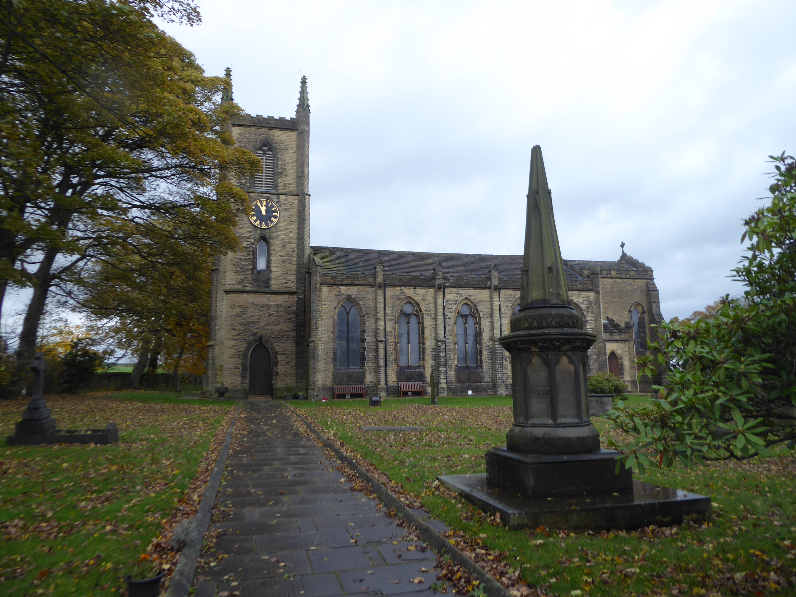
We're off the OL21 map plate as we land up here, to be put away until I next fancy assailing the Pennines, and we've only got the with of E288 to go as we pace on among the space of Withens Field, with its views across to the eastern terrain not seen since the early season, and its farmsteads on the ridge behind us, beyond which the remaining day's weather will come be it rain or shine, before we come around past the eponymous school and the estate at the top edge of Southowram, another settlement which has had only the slightest of visits back in 2012, but will be finally marked off today. It's not a huge shock to find that it's not a massively describable village, with most of its interest being its nomenclature and apparent companion off to the north, and the run down Law Lane presents the sort of front that is to be expected with its rural building surrounded by semis and the run of local stores down to the corner by the Pack Horse inn, where we take a sharp left onto Cain Lane, which presents probably the oldest terrace in the village and council house estate on the north side, while a considerable suburban block grows to its south. The lane away digs itself into a walled groove, as we head back towards the Calder Valley, though getting no marked sightlines in any direction as we pass among the outlying suburban houses and villa around the top of Dark Lane Head, where the Calderdale Way almost brought us on a woodland ascent, eight years back, beyond which the parish church of St Anne is found, offering a sheltered spot in the graveyard as need for refuelling is needed after blasting it out non-stop so far. Five minutes of break also brings the change in the weather for the much worse, as the rain sweeps in from the west, erasing any sense of location of being above the Calderdale woodlands as we carry on east, taking a rapid soaking after a good two hours of drying out as we cross the blank spot on the map along Church Lane, past the old Malt Shovel inn and Birks Royd house and on to the descent towards the lost hamlet of St Anne in the Grove, notable as being the place where our previous path up here ventured onto an ill-favoured cross country trip.
 |
The Green Space of Withen Field.
|
 |
The Pack Horse inn corner, Southowram.
|
 |
St Anne's, Southowram Parish Church.
|
 |
Rainfall like we've rarely experienced, on Church Lane.
|
As we descend following a torrent of water and leaves down past the house that I wonder if it still has an APC in its yard, we drop down past the Marshalls slab, tile and general aggregate works, which seems to be the business of choice on this hillside, as I can think of at least four such enterprises up here, while Brookfoot Lane's steep half mile descent approaches, arriving to have us pass under its tree cover just as the rain eases off, which then proceeds to pass completely as we drop off the hillside, upon the wooded cusp of the Red Beck valley, which is concealed by foliage off to the east of us. The late sunshine greets us as we come down to Brookfoot itself, illustrating well the frustrations that come with trying to plan for late season walking, as we come down to the industrial estate by the side of the A6025 Elland Road, which will carry us over the angrily discharging Red Beck and up past the Red Rooster inn, and on around the tree clad edge of the hillside over which the spread of suburban Brighouse rises to the north of the town centre, which we'll approach via the alternative footpath down to Bank Street, which is paced purely for the sake of variety. Honestly, it's a bit of industrial dead end, only really useful for accessing its car park or the canal path, though finding the old Job Centre on the Owler Ings Road corner is interesting as it apparently only used to offer services for Men and Juveniles, beyond which we can approach the town by the side of the A643, my local road(!) as it passes between the Kwik Fit garage and the Wilko store before passing the Black Bull inn and taking a turn past the market place to rise over the Calder & Hebble navigation by the Bridge Inn and the Millers Bar on Briggate. The turn onto Mill Royd Street takes us past the flour silo with the climbing wall on its exterior, as well as the Rokt climbing gym in the old Brighouse Mills, which offers far more suitable conditions indoors for a day like this, before we a risen up to the A641 opposite Mill Royd Mill with the Huddersfield Road taking us over the Calder Bridge and on past the Commercial Railway Inn to meet the halfway point of our inbound trip at Brighouse station, at 1.15pm, just as the Huddersfield and Bradford trains are passing each other, under a blanket of afternoon sunshine with a colour and chill which already feels like the onset of the early evening.
 |
Brookfoot Road's steep bank.
|
 |
Brookfoot, at the western edge of Brighouse.
|
 |
Brighouse Town Centre, from Owler Ings Road.
|
 |
Mill and Silo with Climbing Wall, from Calder Bridge.
|
5,000 Miles Cumulative Total: 4720.8 miles
2020 Total: 454.3 miles
Up Country Total: 4257.8 miles
Solo Total: 4394.2 miles
5,000 in my 40s Total: 3314.6 miles
Next Up: Is 2020 actually going to get its Finale trip completed?
~~~
Pandemic Thoughts: October
As this month concludes, it feels pretty safe to say that I think we have reached the situation that we all thought would happen, through the path to getting there has proved to be way more convoluted than we could possibly have anticipated, as we've been watching the national Covid infection rate doubling every nine days, forming that already too familiar exponential curve, and a hospital admission rate starting to spike again, and the death rate moving up having plateaued for several months, so on Hallowe'en evening, we finally get HM Government announcing the necessity of a second national lockdown. Just as everyone with one eye on the situation seemed to have anticipated, right since the start of summer, admittedly later by a few moths than I had thought, but much later than the government scientists had been demanding it, as all eyes were on the economic situation and all ears were learnt to those who feared losing business and income, while no one seemed to be looking at the healthcare situation or listening to the needs of the medical profession. It's a rather depressing places to be, looking back and finding out that your worst fears are being realized, again, wondering if the fate of so many has been directed by listening to the wrong set of concerns, like all the talking heads on the local radio, none of whom has anything useful to say about the pandemic situation, as if small businesses, publicans and restaurateurs have a more valid opinions than any doctor or virologist in these complicated times. All I can look at is the news of 100,000 new corona virus infections weekly in the UK, with the most harshly affected groups being secondary school age kids, and the under 25s, and news from Leeds Teaching Hospitals having reached a total of related admissions greater than that at the April peak of the first wave (though with far fewer in ICUs, admittedly), and news of other trusts in West Yorkshire finding themselves close to maximum functional capacity, thanks to attempting to force through the backlog of patients who were unable to receive treatment throughout the initial stages of the pandemic management. The hospital news has sadly come through the related links in my social media, as so much mainstream news has been related to the economic impact otherwise, with so little reflection on what could have been done to mitigate the situation since the large scale lifting of restrictions, with little to no suggestion being that those who would govern us are not seeming to be willing or able to factor in the need for any sort of potential lockdown in the Autumn, despite having had months to plan for it.
It's not like no planning has been going on, even last month there was so much talk of the necessity of a second national lockdown, but so much of it has seemed directionless and poorly focused, with each announcement posing more questions that need answering rather than forcing any decisive actions, and this is what happened when HM Government announced their three tiered regional alert plan, so that areas experiencing the worst and most steeply increasing might have greater restrictions, up to the point of functional lockdown being imposed. That didn't seem to be the way it transpired though, as even the tier 3, the harshest restrictions, stopped short of imposing full lockdown conditions, and even in the case of Liverpool, the first authority to have them imposed, the restriction didn't come into force immediately, and when Greater Manchester was directed into the third tier, the result was the Mayor to demand economic compensation ahead of the new rules being imposed, resulting in days of negotiations and recriminations before the decision was formally accepted. Then the weirdly inconsistent administering of the restrictions seemed to be a factor too, with some authorities, such as Nottingham, being forced into the high tier at barely a moment's notice, with others having suffered poor infection rates for particularly sustained periods, notably Leicester, remaining in the middle group despite not having the full slate of restrictions lifted all Summer, whilst reports kept on claiming that West Yorkshire was either the next to fall into tier 3, or that it wouldn't be happening at all. In the end, it all amounted to several weeks of dithering and functionally useless actions once the decision to impose a second lockdown came around, despite repeated protestations that it wasn't going to happen, and that doing so would be 'unfair' on areas of the country with low infection rates (incidentally ignoring the apparent lag in infections which might make it necessary to impose restrictions later on if the rates rose), meaning all the talk and all the planning for any region going into tighter restrictions was absolutely for naught. Once again, the need for this action was seen from afar, with national governments across Europe taking action as their rates stared to climb again, and the devolved authorities in the UK all acted well ahead of the national body, with Scotland publicly planning for and putting tightened restrictions in place several weeks ago, Wales enforcing severe travel restrictions and a two week fire-break, and Northern Ireland planning a full month of lockdown conditions.
It's so easy to wonder how it came to this, with so little foresight being employed in the circumstance that are starting to become so familiar to us, as over the course of a single work lunchbreak, I managed to retroactively conceive a plan that might have prevented this passage of events, by factoring the need for a severe lockdown right form the start of the lifting of restrictions back in June, which would have allowed people to plan ahead nationwide in the anticipation of it coming to pass, while keeping a close eye on the infection rates as they potentially rose. Thus sending as many people as possible home, for what would amount to a nationally mandated holiday in late September or early October would have meant everyone could have planned for it months in advance, rather than having it dropped on so many people and businesses at such short notice, with all the problems of economic wastage, need for continued furlough payments and risk of surging unemployment being considered and addressed before they happened. All very sensible from where I'm sitting, but I don't have the same perspective as those who would govern us, as they are the sort of people who would reject a publicly supported campaign to provide free school meals to those kids who'd need them across the remaining holidays of the year, and who would have to have a significant number of their own MPs have to remind them that constituencies in the north of England will need financial support from the exchequer since they now represent more of them after last year's elections. So where do we sit as we look to the whole month of November being shut down, though not in the method that we had in the Spring, which if that felt like being imprisoned for many will probably feel like being sent to their rooms to think about what they did, as that's probably a large part of the issue, as so many have regarded the last few months as being completely free to do their own thing, which it honestly wasn't, though I'm a fine one to cast such accusations around, as that's exactly what I've been doing since July. Still, the impending end of my walking year and my solitary nature, combined with continued work at the hospital, means that it's not going to be much of a different month for me, aside from being able to travel away to spend another week with Mum, a development that will upset her immensely, so again I cast my concerns further, hoping that those who need aid are able to get access to it, and that those who most need to isolate themselves from the risk of infection are able and willing to do so.


No comments:
Post a Comment