15.3 miles, via Clover Hill Walk / Cat Steps, Savile Park, Birdcage Hill, Copley Valley,
Spark House, Harper Royd, Norland Moor Bottom, Butterworth End, Barkisland (Cross),
Ripponden Bank, Cob Clough, Cliff Lane, Heys Lane, Hall Green, Moselden Pasture,
Scammonden Bridge. Deanhead, Scammonden Reservoir, Scammonden Dam, Wood Edge,
O'Cot, Worts Hill, Ainley Place, Clough House, and Hill Top Reservoir.
Sunday walking comes around again, due to Saturday inclemency and the promise of a much brighter day subsequent to it, and as we can still do inessential travel, despite the worsening Covid infection rates, busing and training it the log way around can get us to Halifax for a 9.55am jump off, alighting for a later start than usual under the brightest of late season blue skies, which illuminates the area around the Square Chapel and the Piece hall as we rise away up Horton Street, feeling like we've arrived in town ahead of all the regular local shoppers. Of course there are other reasons for the quiet, but that means I'm not going to look like so much of a stranger as we make our way up to the Royal Oak corner and angle ourselves away up St John's Avenue on the day's southwesterly trajectory, rubbing us right up against the town's old urban terraces that butt right up next to the Lloyds Bank offices, beyond Commercial Street, which gives us a nice contrast of Victorian and Modernist before we delve off into the suburbia which lies beyond Savile Road, where older villas and their estates got consumed in waves over the last century. So it's on among the semis on Well Head Lane, and thence into the more contemporary Lego houses on Central Park, seeking the Clover Hill Walk path as it traces its old course through the slight depression in the landscape, before we meet the steep rise of the cobbled Cat Steps path that leads us up into the terraced district to the east of Savile Park, which we approach via Clover Hill Road and Free School Lane, ahead of arriving by St Jude's church. We'll make our way down its eastern perimeter, along Queen's Gate, in front of the villas that have the prime location overlooking the expanse of grasslands and the avenues of trees, ahead of Wainhouse Tower and the Crossley Heath school, and in the current climate, it's good to see how many people have still come out to make use of it on a sunny morning, be it to jog, meet up with their dog-walking group or do a spot of circuit training in the fields beyond the lodge and chip shop, which we pass on our way to crossing the A646 Skircoat Moor Lane at its southern end. We are then drawn on, into the landscape of walled estates that have mostly had their gardens claimed by upscale suburbia, passing the Southwood Club and the Gleddings Prep School on Birdcage Lane, which provides our route off the town's plateau and into the wooded north bank of the Calder Valley, as we meet the path of Birdcage Hill dropping sharply downhill between the ancient woodlands of Long Wood and Scar Wood, before giving us some setts to carefully trace our way down on Woodhouse Lane.
 |
Halifax on an sunny Sunday morning.
|
 |
The Lloyds building and the residential edge of town.
|
 |
Clover Hill Walk and the Cat Steps.
|
 |
Savile Park.
|
 |
Birdcage Hill.
|
We meet Wood Hall at the bottom of the route to the valley floor, and get a better view of it than we did when we last passed by in February, and we'll again tangle up with the A6026 Wakefield Road as we aim ourselves towards the southern side of the Calder, splitting off onto Hollas Lane by the other Lloyds Bank offices and trace this relatively new lane down as it passes over the Calder & Hebble navigation, and among the managed wetlands that seem to have been planned out to protect the new housing development that seems perilously close to the river. Pass over the Calder, just upstream from the V-shaped weir and follow the new-ish Copley Valley Road as it slips between the eponymous industrial estate that occupies the level riverside plots and the embankment of the railway line, right about in the vicinity of Milner Royd junction, ahead of taking its merry old time to get to the next junction, passing a field of abandoned allotments and an oddly hard to access nature reserve before we land at the end of Mereclough Road by the recycling facility and the riverside factories at the bottom of Fall Lane. Uphill is now our path, taking the turn onto Fall lane as it starts its steep path us the south side of the valley, rising us up through a bank of trees and over the railway via on of the most impressively scaled bridges on the line, which really can't be appreciated when upon it, ahead of the push up to the reveal of the wooded reach of the valley, downstream of Sowerby Bridge as we come back up to Spark House Lane, to traverse among the Bethel Chapel, the perched terraces and the Spark House farmstaeads as we move above the town below and angle ourselves away from the Calder and into the the Ryburn valley. It's the most subtle of landscape transitions, with a new path emerging as we switch onto Harper Royd Lane as we pass over Sowerby Croft lane, keeping on with this contour as we pass among another hamlet of farmsteads cottages and terraces perched above the valley, coming around to the view by the Clough Head Terrace and then hitting the ascent as the lane rises up to the New Hobbit inn and hotel complex, looking like the ideal spot for an out of the way wedding reception, like the Pennine Manor at Longroyd Common but with more vintage appeal, ahead of the continuing rise of Hob Lane elevating us above the Ryburn valley. Thus we have an uphill push to make to get onto another of this year's lanes, confirming our late season as a bit of a victory lap over the terrain we have broken this year, setting off between raised walls among the high fields to the west of the golf course to meet the ideally placed country retreats at Hollin Lane Top, Sun Longley and Rough Hey as they claim all the views above the meeting of the Calder and Ryburn valleys, as we push up to Norland Moor Bottom by its eponymous cottage.
 |
Wood Hall, near Copley.
|
 |
The Calder valley floor, with Wainhouse Tower.
|
 |
| The high terraces on Spark House Lane. |
 |
The New Hobbit inn.
|
 |
High above the merging Ryburn and Calder.
|
Below the rough north edge of the moor we walk once more, still not seeking a route onto it despite not having been up there since 2012 and having plotted paths that completely encompass it this year, retracing steps that lead us past the Bents Farm nursery and the Moorcock inn before we resume a new path beyond the Longley Lane corner, joining Butterworth End Lane as it takes us past the former Halifax Children's Holday Home, a one time hostel for the waifs and strays of the town, I'd assume, ahead of the rise of the road below the Ladstone Rock end of the moor and the reveal of the upper Ryburn Valley beyond. It's good to have the sunshine on to illuminate it as we look on over the high faields and farmsteads on the east bank to Manshead Hill and Rishworth Moor, showing up the disturbance of probable ancient landslips on the north side side of Dog Hill, while locally noting that this corner of the valley seems to be the place to purchase your retirement caravan, as there are parks developed for them at Upper Butterworth and Upper Abbots Royd farms, an observation originally made when the Calderdale way brought us this way in 2012. So we'll share that route for a while as it drops down with the renewed footway to the old New Rock inn and the Highlee Lane corner, before we continue with Scammonden Road, shifting us over the Ryburn - Blackburn valleys crest to the eastern side, and giving us some downstream views to the east as the western horizon is briefly obscured by green fields, while also offering us a direct route to our feature destination of the day, which we've seen too much of already on our travels, so we'll be aiming back into the Ryburn as we meet the A6113 Greetland Road on the upper edge of Barkisland. This really has been one of those locations where paths have converged this year, which probably says something about the geography of this side of the Ryburn valley, as we pass around the northern suburban edge of the village and come down to the meet the merging lanes at Barkisland Cross, to get onto familiar lanes once again as we meet Ripponden Bank top, where the aroma of Sunday dinner wafts out of the Fleece inn and the bank roads split to descend into the town below, and we have to shed altitude with New Bank to keep us on the path we seek to the south. We'll drop down to meet the sharp angle of the road before finding a particularly dangerous spot to cross, with blind corners on both sides, to get to Bank Hey Bottom Lane, which directs us into the gouge formed by Cob Clough, which we pass over as it cascades below the roads, and we start the twisting rise of the minor lanes beyond to get us back up high and past the Upper Bank Hey Bottom terrace to new views over the Ryburn Valley, downstream and upstream above Ripponden.
 |
Norland Moor edge.
|
 |
The Ryburn from Butterworth End.
|
 |
Norland Moor's southwestern edge, and caravans.
|
 |
Barkisland Cross.
|
 |
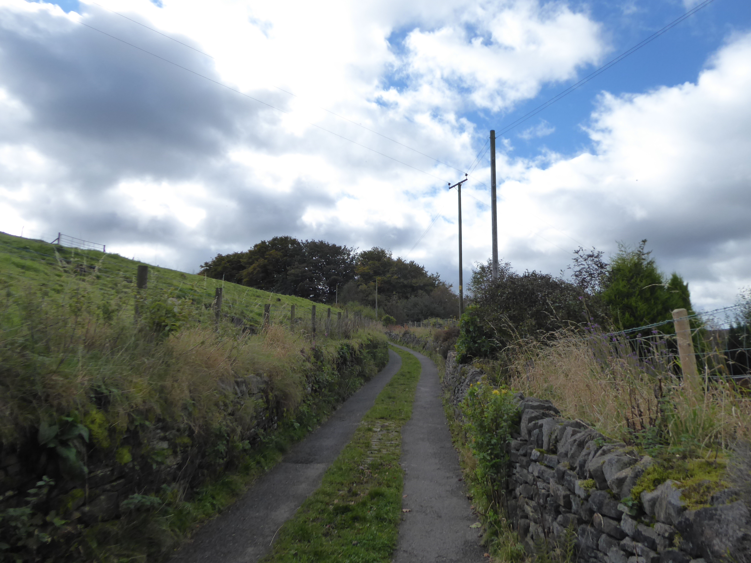
Cob Clough
|
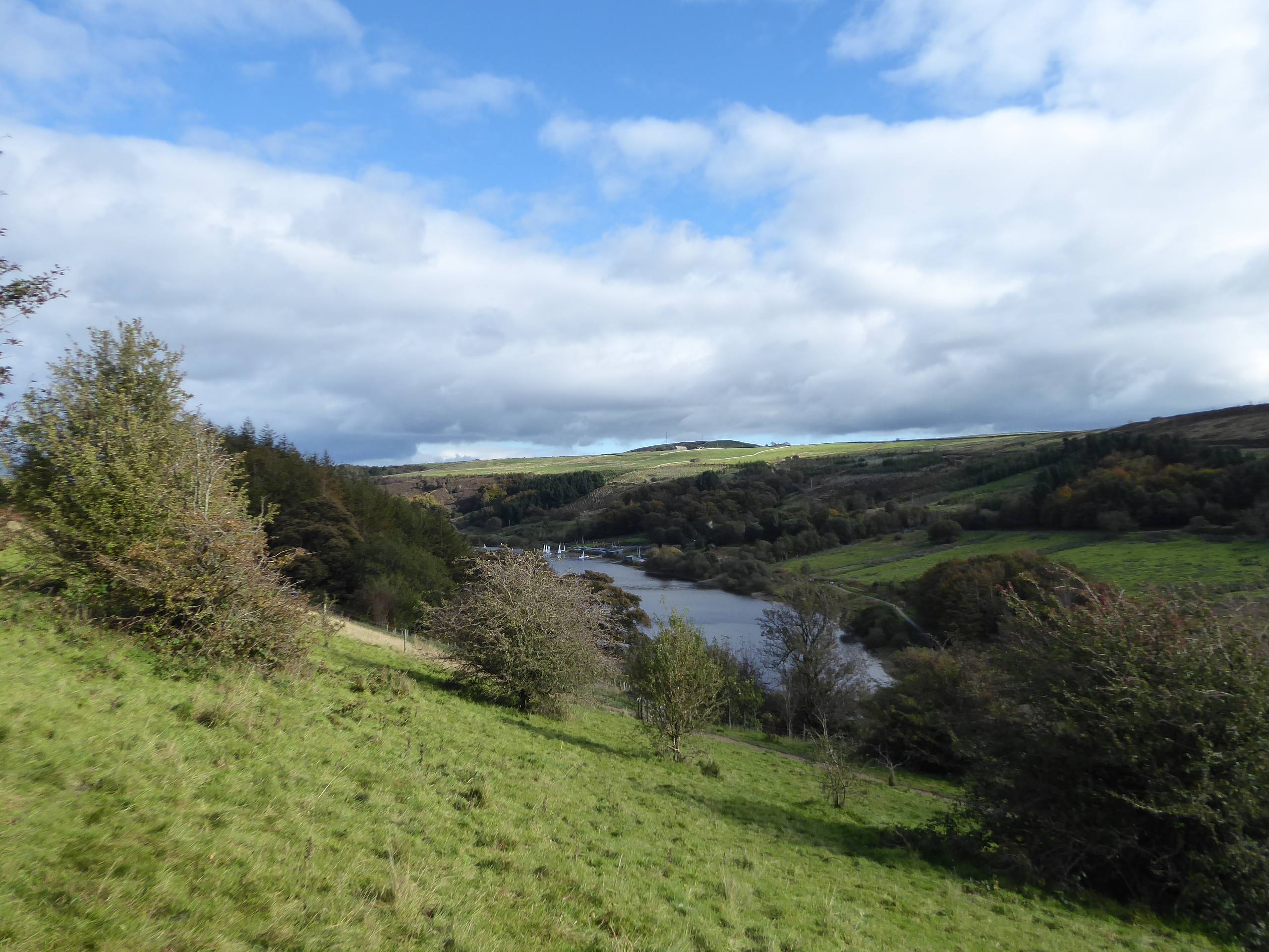
Taking the mostly elevated route around the high lump of Ringstone Edge moor, which sits to the southeast of our route, has us deep among the farm access lanes that seem to have more comings and goings from them as we try to not descend or ascend in the wrong directions, keeping to the contour as it passes below on the edge of Cliff Lane as it directs us southbound, towards the end of the tarmac at the Springfield terrace and giving us views that give us a complete contrast to the feel gained when pacing the old railway route away from Rishworth in the valley below. Hit the rough bridleway as we progress on, taking time to absorb the spread of the village in the valley below, around the grammar school complex and upstream to the Ryburn and Baitings Dams, as Rishworth Moor fills the southern horizon and the nab of Pike End rises at its eastern extremity, as we are gradually drawn into the lower branch of the valley, past a ruined barn and trees covered with the most entertaining forms of fungi, ahead of our umpteenth passage below the trans-Pennine pylons as they head west over the uppermost stretch of Booth Dean. We hit the descent of Heys Lane beyond them, with the surface getting deeply unfriendly as we pass around Rishworth Mills in the valley below, both uneven and wet as we come down to meet Butts Clough as it flows down from Ringstone edge reservoir, completely inundating the ford on the lane, which has us grateful that a footbridge has been laid out passing over an I-beam, which gets us dryly onto the stretch up to Hall Green Lane by the old Spread Eagle inn, where we almost get run down by a group of off-road motorcyclists, heading onto the route we've just completed. Onto a familiar lane once more, with the legs feeling sturdier than they did in July as we hit the cobbled ascent up to the Hall Green farms, which reveals our last batch of views across the upper Ryburn before we make our decisive passage past the Pike End of Rishworth Moor to the west and rise on with elevating lane as Moss Moor Edge rises to form our southern horizon, bring the loud hum of the M62 into the landscape as we pass among the marginal farmlands above Booth Dean, revealing Booth Wood dam and reservoir at the heart of the valley. Meeting Withens End Lane has us on yet another passage across these valleys, ahead of us joining the track to the remote Croft House complex, home to an off-road biking course on the moorland edge, which we'll move away from as we seek the rough path rights of way that lead over the valley crest at Moselden Pasture, gaining the grassy track beyond the inconvenient barbed wire fence that leads us up to the catchwater drain that feeds the reservoir off to the north of Withens Edge, across which we'll pause to look west to the Pennine spine at Windy Hill and break for lunch, as a strengthening northwesterly wind brings on an unwelcome Autumnal chill.
 |
Rishworth and the Upper Ryburn.
|
 |
Rishworth Mill and Pike End.
|
 |
Ascending Hall Green Lane.
|
 |
Booth Dean, with Reservoir and moorlands.
|
 |
The Withens Edge Catchwater Drain.
|
Post resting and feeding, we hit the rising path through the moorland grass, which we mostly trace by dead reckoning as we land between the Clock Face quarry and the motorway, gradually being draw to the side of the latter as we need to take a close look at how the M62 gouged a deep, and wide, cutting through Moselden pasture, and across the Ryburn - Blackburne ridge, a cleft which Scammonden Bridge rises over, and my hope that it may be accessible after 12 weeks of closure are proved to be correct as a single carriageway of traffic on the B6114 is spied passing over. So we come down to Saddleworth Road to head south over it, a mere three months late, though I do have to pause to get a contractor's attention to confirm that it is safe to cross, which it is so long as I stay with in the cones and don't step in the freshly laid footways, which means views aren't that easy to nab, especially as the tall and newly installed anti-suicide fence obscures things further, but it's a feature to chalk off as we land back in the Blackburne valley as we seek the best route to visit the reservoir beyond in the time available. That means retracing our steps down Ryefield End Lane, down the southeastern side of the motorway cutting to meet the stub end of Scammonden Road as it continues south, above the Lower Top of Hill farmstead and above the body of Scammonden Reservoir (or Water, if you prefer) as it reveals itself in the high end of the valley below, starting a circuit visit that has been a long time coming, so late in the year that the seasonal car park on this western side has been closed to usage, despite the fine views that it offers. The lane shifts downhill to meet the old Bay Horse inn and Top of Hill farm, as we come down opposite the boating club on the east bank, and arrive in the enduring corner of Deanhead (or Scammonden) village, which has a schoolhouse and a church, St Bart's, which claims an establishment vintage of over four centuries, but not a greatly inhabited parish despite the farms lost below the reservoir's surface, now forming a pleasing little picturesque curiosity in the tree-clad landscape of the upper valley. Beyond the church yard we seek the path that leads downhill gradually, through the trees of Scar plantation and the rough grounds beyond, before heading into the open fields that angle us down towards the perimeter path, giving us looks across the upper southern end of the reservoir and up to the top of Deanhead Clough, where the upper dam contains its own reservoir below the moorland edges where paths carried us in 2013/4, in conditions far less favourable than the ones we are enjoying today.
 |
The M62 cutting, Moselden Pasture.
|
 |
| Scammonden Bridge, open to traffic once again. |
 |
Scammonden Reservoir from Ryefield End Lane.
|
 |
St Bart's church, Deanhead.
|
 |
The heel of Scammonden Reservoir.
|
Meeting the long permissive path, it's encouraging to see how many people have brought their families out for a tour as this is a pretty hardcore walk for young and old alike, as single circuit is going to be an hour of walking, with an unavoidable descent and climb at either end, and I'll get the feeling that we are going against the popular grain as we drop down to meet the passage of the Black Burne Brook at the southern feed of the valley and set off up the eastern bank, the only section that has been previously traversed with the Kirklees Way route as it lands us on the shore where on of the few views along its length is attainable. Press on north-ish with the sun on our shoulder as the path comes down to the New Hey farm and Deanhead vicarage sites, where the path is pushed away from the shore to pass around the outward bound centre and the boating club, giving us enough elevation to look back across to the moorland edges at the top of Deanhead Clough to spy the folk out paragliding on the prevailing breeze, ahead of us pressing on around the private sites and getting the view across to Deanhead village in all its picturesque glory. Drop down to the shoreline once again as we meet a deep clough which is charging water into the reservoir at a rate, as the high moors empty yesterday's rain back into the rivers, and that's a bit of a theme down this western side, as streams run regularly down through the tree lined bank, and under the path that offers views to the dam and motorway and up past the numerous amateur yachtsmen, finding that this path is by far the most popular with other tourers thanks to the proximity of the main car park above. We'll keep to the low paths to maintain our circuit, rising slightly away from the shoreline to enhance the views to the heel of the reservoir and the deep valley it resides in as we set course for the northeastern corner, where we don't really get a closer look at its modernistic valve tower, too concealed by trees, and thus we look more at the ceremonial flagpole and compass rose which celebrate the reservoir's inauguration in 1971 by HMQ, ahead of us taking the access road tunnel under the M62 to the north face of the dam again. Hopes of getting some sunlit views down the Blackburne Valley are lost as the cloud cover greys things out for a while, and the appeal of wandering down the hill climb route and up the damside or the steps flight don't appeal as the day starts to feel the chill of October, and so we loop around the pavement to get up to the path across the dam top, retracing our previous steps unavoidably as we head back to the western bank, and towards Scammonden Bridge as it soars over the deep cutting ahead, before meeting that foot tunnel once again.
 |
The South-Eastern shore.
|
 |
Deanhead clough and dam.
|
 |
| Looking North to Scammonden Dam. |
 |
Looking southwest to the Deanheads, various.
|
 |
Scammonden Dam and Bridge.
|
If time were on our side, a traipse up the western side of the perimeter path, and thence onto the high lane to the east would really do a number on this reservoir, but it's too late in the season for additional miles, and thus we have to immediately make our way back across the dam to the eastern shore, getting a decent burst of illumination of the silvery surface as we pace by the motorway and the valve tower below before we meet the rising path that will take us up the side of Wood Edge, which feel like its always been a naturally wild landscape. Wander some to meet the northeastern viewpoint that is gradually having its aspect ruined by tree growth, and then follow the path that leads into the car park that has all the best views over the reservoir, which we'll pace through before finally turning our back on Scammonden Water and make the break off towards the Colne valley, which means we need to press away up Green Slacks Road, past the kennels and cattery, and among all the visiting cars parked all the way up to the Camp Hill terrace, beyond which the watershed hills emerge. It's a nice little ridge to observe, from Stainland Moor around to Wholestone Moor and Worts Hill, the latter of which we'll approach directly, up the slog of O'Cot Lane among some oddly regular fields on this marginal moorland, before we meet the eponymous farm hamlet at the top, where you can look back down the Blackburne valley to see the terrain we saw earlier in the day lit up in the afternoon sunshine, and then land on the A640 as it makes its passage over the Pennines, not to be seen up close this year, at least. Across the New Hey Road we hit the grassy path that takes us up onto the edge of Worts Hill, hammering out a sharp climb to hit the walled route over the top of the ridge, which gets us high enough to get another fine revelation of the southern Calderdale landscape, which we've seen so much of this year, giving us a panorama from over 380m up that encompasses the Pennine watershed and the Calder-Aire ridge, with the keen eye being drawn beyond Bradford to spy the Kilburn White Horse, on the North York Moors corner, 50 miles distant. It's a lot more revealing than when the Kirklees Way drew us over here six years ago, and we won't be following that route for too long as we cross towards the Colne Valley side, taking the path that grazes the summit plot of the hill and gives us the revelation of the high valley's company, of Deer Hill and Pule Hill, while also giving us an uninterrupted downstream view across the district and right down the river valleys to the power station of the lower Aire and the dark horizon of the Wolds, even further away and revealing this high land as on of the best secret viewing platforms in the county.
 |
The Valve Tower from Scammonden Dam.
|
 |
The best view from the car park atop Wood Edge.
|
 |
O'cot Hamlet in the shadow of Worts Hill.
|
 |
The Blackburne Valley from Worts Hill.
|
 |
The Upper Colne Valley, from Worts Hill.
|
I could linger up here for a while in the late afternoon sunshine, but we've a deadline to meet as the day starts to cool down, and we follow the muddy field walk down to Worts Hill Side, and then seek the troublesome path that traces the field boundaries downhill between the Worts Hill and Poor House farmsteads, never quite sure of which side of the fence we're meant to be in ahead of landing by the Moor Top house driveway and angling ourselves onto Burnt Platts Lane which drops Moorside edge onto our horizon, ahead of us meeting Launds Lane again. There are no straightforwards descents to the finish line here, with both Barrett and Merry Dale cloughs interrupting the local landscape and we'll trace Intake Lane as it shadows the former of them, steeply descending down to the farm hamlet of Ainley Place, where we passed through on the Colne Valley Circular, and we angle ourselves through this cluster of ancient buildings and its yards to meet the track beyond, which is damp in the extreme, leading us to an open field walk, past an enclosure of alpacas. Ahead we have the rise of Cop Hill, with its mast and pub atop it, as we drop down towards the bottom of the merging cloughs, the path through the woods to the lane isn't obvious, found beyond the pen of roaming chickens which takes us over the foot of Barrett Clough and among the cottages on Clough House Lane, which once served the eponymous mill now lost among the woods on Merry Dale clough, of which only the millpond and fragments of the access road remain as they lead us on to meet the ongoing path beyond the weir, between the beck and the goit runoff. The wooded clough opens out as we arrive alongside Hilltop reservoir, built as a feeder for the Narrow canal rather than to serve the town of Slaithwaite that has grown up to meet it, and despite having a waterside path, its mostly hidden from view by foliage as we progress down below the steeply declining back gardens of Longlands Road, with the views only being available for the anglers until we arrive by the dam, which looms rather ominously above the town in the valley below, and we cross to the south bank as the low sun lightens the surface. Approach the town via the steep drop of Holme Lane, which takes us under Slaithwaite viaduct, the second of the two which rise above the side valleys dropping down to the Colne, beyond which we get the most pleasing sort of foregrounds to the looming arches among the cottages on Nabbs Lane that line up ahead of the Silent Woman inn and St James' parish church, beyond which we meet the town centre by the Shoulder of Mutton and the canalside, which means its back uphill to the station, with its road being hammered up to conclude our day on schedule, just as the day's remaining warmth finally lapses, at 4.20pm.
 |
Burnt Platts Lane and Moorside Edge.
|
 |
Ainley Place and its Alpacas.
|
 |
Clough House Millpond.
|
 |
Hilltop Dam and Reservoir.
|
 |
Slaithwaite Viaduct, and Company.
|
5,000 Miles Cumulative Total: 4684.1 miles
2020 Total: 417.6 miles
Up Country Total: 4221.1 miles
Solo Total: 4357.5 miles
5,000 in my 40s Total: 3277.9 miles
Next Up: Finally getting to this year's Urban Circular?


No comments:
Post a Comment