Elland Wood, Salterhebble, Skircoat, and the Piece Hall.
Thanks to the weather it looks like my schedule isn't going to have much space for recovery time between trips, so it's just a well that I'd only planned a short excursion for today, the sort of distance that's too short to dedicate a whole day to, not that Northern Fail are doing anything to help me along, with their services delaying my arrival into Huddersfield by a quarter hour, showing that they've really given up on their business ahead of being stripped of their franchise at the end of the month. So we alight at 10.25am, with the day's sunshine already retreating from view as we get off to an inauspicious start, finding the favoured route from St George's Square blocked by roadworks, and thus a detour take us along Railway Street and West Gate to pass over the station throat and then set a course along New North Parade, the southernmost stub of the turnpike that has been severed by the Castlegate ring road, and this doesn't present a direct way forward until we've gone under the Trinity Street underpass and emerged by the old town infirmary. Once we've passed St Patrick's RC church, New North Road finally gets us going, with the A629 finally taking us towards Halifax, leading us on among the most attractive sort of early 19th century suburbia, showing up the sort of vintage suburban front that doesn't immediately having you thinking of what Huddersfield looks like, finding the castellated Highfields Centre in its midst across the way from Holy Trinity church, and adjacent to the overstated Congregational chapel and Sunday school, as we press on through Victorian townhouse to the Blacker Road corner. Beyond, things get a whole lot leafier as Edgerton Road settles into a landscape of villas with extensive grounds and gardens along the valley edge on which it runs, taking us past the sole surviving tram stand in the town as the houses retreat away from the roadside and behind their banks of trees, which give the whole of the Halifax road a feeling of being ahistorical as none of what you might expect to see along a major town road appears in suburban Edgerton as we pass our next previous contact point at Daisy Lea Lane. It seems that nearby Lindley must provide the facilities for this part of town, and we don't meet a pub until we encounter the Cavalry Arms at the East Street corner, just across from the Mormon temple, meeting some actual vintage cottages and terraces once we hit the urban hamlet of Prince Royd, where a brewery and a brickworks once brought some industry to this lane, beyond which Huddersfield's outer suburban band can be found as we pass into Birchencliffe.
Main feature of this urban village is St Philip's church, with its squat and unfinished-looking belltower, as well as actual facilities in the Co-operative filling station and the Briar Court Hotel, though where the Kirklees Way brought us through in 2014 isn't immediately obvious until we encounter the sign on Yew Tree Road, and there isn't much of Huddersfield beyond there as the mast on Fixby Ridge indicates the top of the town off to the east, as does the Ainley Top traffic island on the road ahead. We'll not venture into the suburb that has grown on the junction of the old roads above the crossing of the contemporary A629 and A643, instead sticking to Halifax Road as it slips between the Toby Carvery and the Clarion Cedar Court Hotel and into the rock cutting that predates the modern roads to pass downhill and under the vast sounding arch that carries the M62 overhead, departing the Colne Valley and then not getting the Calderdale reveal beyond as it's just too grey and hazy for views. It's a sharp downhill decline from here as we loop around above Elland in the valley below, with the footway drifting away from the roadside as we decline, not really getting any of the views to our destination as we slip down below the high watershed ridge, regaining the side of Huddersfield Road as the A629 Calderdale Way runs overhead and onwards as we meet the stray houses at the roadside in Storth, where the industrial outer edge of Elland still endures, although the suburban edge seems to be encroaching into its landscape of yards and factories. We get a fine elevated horizon as we slip into the town though, meeting its terraces and mills ahead of the Aldi store and the Travellers Rest inn, with the sunshine threatening to return as we come down to the Southgate corner, where Elland's former Town Hall buildings rise prominently, across from the spired Methodist church, and the road size continues to diminish as we run into the town proper, narrowing markedly as Southgate leads us among its stores and past the Wellington inn and Savile Arms to the town's ancient centre.
It's all very quite down here on a Thursday lunchtime, with the world doing its business elsewhere for the most part, and we'll join the implausibly cramped Northgate as it passes the parish church of St Mary the Virgin and progreses downhill steeply to meet Briggate, landing by the pleasingly Baroque former bank by the Malt Shovel inn, which sit at the end of Elland Bridge, below which the Calder flows busily after the weekend's rains, far short of the flow rate which put the bridge out of use for months after the floods of December 2015, beyond which we pass over the Calder & Hebble Navigation, marking our previous closest pass to this town. We also meet the end of the A6025 Halifax Road as it comes below the looming A629 pacing its narrow pavement by the industrial buildings at the canalside with progress being tightened by simultaneous demolition work and pipe-laying before we come to the side of the Calderdale Way, to pace the footway by the dual carriageway, below the rocky outcrops and perched trees on its eastern side, to the point where Elland tunnel emerges with the Calderdale line before passing over both canal and river to the west. Slip off the roadside for a stretch, above Long Lee lock, and then meet the Calderdale Way passage as it comes down across the A629, where we cross to join the wide cycleway route as it comes down below Elland Wood, which thickly coats the roadside as signage greets us into greater Halifax, some way ahead of where the the roads to Stainland and Sowerby Bridge tangle up above the Salterhebble lock flight, and Hebble brook. Huddersfield Road thus takes us into the wooded cleft of the Hebble Valley, and onto the last hour of the trip, with the footway keeping us away from what feels like it ought to be a view down the the valley floor, but the high wall conceals not a view of river or canal, as only the town sewage works is hidden away before we land in Salterhebble proper, at the top of the Hebble canal branch and at the bottom of the steeply rising hill road up the valley's western side where a terrace end's ghost sign still proudly advertises 'Bile Beans' to the passing traffic as carries on uphill.
The day's sunshine lapses as we come up among the terraces and the Chrstadelphian hall at the top of Salterhebble Hill, blunting our views across the valley to Siddal and Exley, and thus focusing our attention on the locality as we press into town, passing over the merging railway lines before we spy the statement buildings of Calderdale Royal Infirmary, which are styled somewhere between oasthouses and upturned jam funnels, a fashion that has spread beyond the old hospital site to the newer buildings which share their circular theming. The spread of mostly old suburbia carries us on the still rising road, with the villas and terraces of Skircoat crowding the roadside as far as the Spring Hall sports facilities, where the valley view opens up again towards Bank Top, and we have to pick a path as we come up past the the former tram depot where First now part their buses, sticking with Skircoat Road as it passes to the west of it, and noting the nearby equestrian statue of Prince Albert, as that's the second royal sculpture of the trip, having spied KE7 at the infirmary site in Huddersfield, hours previously. Before we land in the town, we come up past The Shay, the long time home of Halifax Town FC, and also Halifax RLFC more recently, peering over the boundary wall to get the best free view of the pitch like a sneaky child before the push into the town resumes, passing the former town Higher School and the modern swimming baths, beyond which the Halifax Building Society HQ looms, as we seek a away into the town centre via Clare Road, another late Georgian residential street of the kind that you just don't expect to see in a northern town like this. It up's Halifax's visual appeal mightily as we carry on, past the Quakers meeting house and the Royal Oak inn, landing at the bottom of the shopping drag of Southgate, where the former Theatre Royal looks like the town's premiere redevelopment opportunity, beyond which we take a turn down the Westgate Arcade, again, to approach the Piece Hall once more, now open again after an extensive hiatus for restoration and redevelopment that prevented a tour back in 2014. No such losses this time, as this 18th century cloth hall and plaza is open and busy despite the gloomy weather, though the boutiques and bars that surround the mezzanine terrace won't be seeing my business as a full circuit is quickly taken in to see all its vistas, especially those with the spire of the Square chapel looming above it before we pass out to the Cross Street entrance, and join Horton Street, to lead us down the station, to close the trip at 1.35pm, too late to guarantee the shortest possible ride home but early enough to fit in a shopping trip along the way, before a treat of F'n'C is in order, methinks.
5,000 Miles Cumulative Total: 4296.8 miles
2020 Total: 30.3 miles
Up Country Total: 3833.8 miles
Solo Total: 3982.6 miles
5,000 in my 40s Total: 2890.6 miles
Next Up: One last Calderdale - Kirklees trip for the week before the next round of storms.
Thanks to the weather it looks like my schedule isn't going to have much space for recovery time between trips, so it's just a well that I'd only planned a short excursion for today, the sort of distance that's too short to dedicate a whole day to, not that Northern Fail are doing anything to help me along, with their services delaying my arrival into Huddersfield by a quarter hour, showing that they've really given up on their business ahead of being stripped of their franchise at the end of the month. So we alight at 10.25am, with the day's sunshine already retreating from view as we get off to an inauspicious start, finding the favoured route from St George's Square blocked by roadworks, and thus a detour take us along Railway Street and West Gate to pass over the station throat and then set a course along New North Parade, the southernmost stub of the turnpike that has been severed by the Castlegate ring road, and this doesn't present a direct way forward until we've gone under the Trinity Street underpass and emerged by the old town infirmary. Once we've passed St Patrick's RC church, New North Road finally gets us going, with the A629 finally taking us towards Halifax, leading us on among the most attractive sort of early 19th century suburbia, showing up the sort of vintage suburban front that doesn't immediately having you thinking of what Huddersfield looks like, finding the castellated Highfields Centre in its midst across the way from Holy Trinity church, and adjacent to the overstated Congregational chapel and Sunday school, as we press on through Victorian townhouse to the Blacker Road corner. Beyond, things get a whole lot leafier as Edgerton Road settles into a landscape of villas with extensive grounds and gardens along the valley edge on which it runs, taking us past the sole surviving tram stand in the town as the houses retreat away from the roadside and behind their banks of trees, which give the whole of the Halifax road a feeling of being ahistorical as none of what you might expect to see along a major town road appears in suburban Edgerton as we pass our next previous contact point at Daisy Lea Lane. It seems that nearby Lindley must provide the facilities for this part of town, and we don't meet a pub until we encounter the Cavalry Arms at the East Street corner, just across from the Mormon temple, meeting some actual vintage cottages and terraces once we hit the urban hamlet of Prince Royd, where a brewery and a brickworks once brought some industry to this lane, beyond which Huddersfield's outer suburban band can be found as we pass into Birchencliffe.
 |
| The stub of New North Parade, Huddersfield. |
 |
| The Highfields Centre, New North Road. |
 |
| The Edgerton Road Tram Shelter. |
 |
| The devoid of settlement Halifax Road. |
Main feature of this urban village is St Philip's church, with its squat and unfinished-looking belltower, as well as actual facilities in the Co-operative filling station and the Briar Court Hotel, though where the Kirklees Way brought us through in 2014 isn't immediately obvious until we encounter the sign on Yew Tree Road, and there isn't much of Huddersfield beyond there as the mast on Fixby Ridge indicates the top of the town off to the east, as does the Ainley Top traffic island on the road ahead. We'll not venture into the suburb that has grown on the junction of the old roads above the crossing of the contemporary A629 and A643, instead sticking to Halifax Road as it slips between the Toby Carvery and the Clarion Cedar Court Hotel and into the rock cutting that predates the modern roads to pass downhill and under the vast sounding arch that carries the M62 overhead, departing the Colne Valley and then not getting the Calderdale reveal beyond as it's just too grey and hazy for views. It's a sharp downhill decline from here as we loop around above Elland in the valley below, with the footway drifting away from the roadside as we decline, not really getting any of the views to our destination as we slip down below the high watershed ridge, regaining the side of Huddersfield Road as the A629 Calderdale Way runs overhead and onwards as we meet the stray houses at the roadside in Storth, where the industrial outer edge of Elland still endures, although the suburban edge seems to be encroaching into its landscape of yards and factories. We get a fine elevated horizon as we slip into the town though, meeting its terraces and mills ahead of the Aldi store and the Travellers Rest inn, with the sunshine threatening to return as we come down to the Southgate corner, where Elland's former Town Hall buildings rise prominently, across from the spired Methodist church, and the road size continues to diminish as we run into the town proper, narrowing markedly as Southgate leads us among its stores and past the Wellington inn and Savile Arms to the town's ancient centre.
 |
| St Philip's church, Birchencliffe. |
 |
| The sounding arch of the M62, Ainley Top. |
 |
| Descending into Elland, via Storth. |
 |
| Elland Town Hall (former), Southgate. |
It's all very quite down here on a Thursday lunchtime, with the world doing its business elsewhere for the most part, and we'll join the implausibly cramped Northgate as it passes the parish church of St Mary the Virgin and progreses downhill steeply to meet Briggate, landing by the pleasingly Baroque former bank by the Malt Shovel inn, which sit at the end of Elland Bridge, below which the Calder flows busily after the weekend's rains, far short of the flow rate which put the bridge out of use for months after the floods of December 2015, beyond which we pass over the Calder & Hebble Navigation, marking our previous closest pass to this town. We also meet the end of the A6025 Halifax Road as it comes below the looming A629 pacing its narrow pavement by the industrial buildings at the canalside with progress being tightened by simultaneous demolition work and pipe-laying before we come to the side of the Calderdale Way, to pace the footway by the dual carriageway, below the rocky outcrops and perched trees on its eastern side, to the point where Elland tunnel emerges with the Calderdale line before passing over both canal and river to the west. Slip off the roadside for a stretch, above Long Lee lock, and then meet the Calderdale Way passage as it comes down across the A629, where we cross to join the wide cycleway route as it comes down below Elland Wood, which thickly coats the roadside as signage greets us into greater Halifax, some way ahead of where the the roads to Stainland and Sowerby Bridge tangle up above the Salterhebble lock flight, and Hebble brook. Huddersfield Road thus takes us into the wooded cleft of the Hebble Valley, and onto the last hour of the trip, with the footway keeping us away from what feels like it ought to be a view down the the valley floor, but the high wall conceals not a view of river or canal, as only the town sewage works is hidden away before we land in Salterhebble proper, at the top of the Hebble canal branch and at the bottom of the steeply rising hill road up the valley's western side where a terrace end's ghost sign still proudly advertises 'Bile Beans' to the passing traffic as carries on uphill.
 |
| Elland Bridge, on the River Calder. |
 |
| Demolition and Pipe laying on the Halifax Road stub. |
 |
| The A629 and Elland Wood, below greater Halifax. |
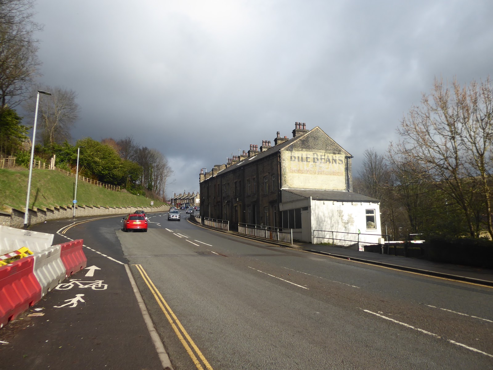 |
| The 'Bile Beans' terrace, Salterhebble. |
The day's sunshine lapses as we come up among the terraces and the Chrstadelphian hall at the top of Salterhebble Hill, blunting our views across the valley to Siddal and Exley, and thus focusing our attention on the locality as we press into town, passing over the merging railway lines before we spy the statement buildings of Calderdale Royal Infirmary, which are styled somewhere between oasthouses and upturned jam funnels, a fashion that has spread beyond the old hospital site to the newer buildings which share their circular theming. The spread of mostly old suburbia carries us on the still rising road, with the villas and terraces of Skircoat crowding the roadside as far as the Spring Hall sports facilities, where the valley view opens up again towards Bank Top, and we have to pick a path as we come up past the the former tram depot where First now part their buses, sticking with Skircoat Road as it passes to the west of it, and noting the nearby equestrian statue of Prince Albert, as that's the second royal sculpture of the trip, having spied KE7 at the infirmary site in Huddersfield, hours previously. Before we land in the town, we come up past The Shay, the long time home of Halifax Town FC, and also Halifax RLFC more recently, peering over the boundary wall to get the best free view of the pitch like a sneaky child before the push into the town resumes, passing the former town Higher School and the modern swimming baths, beyond which the Halifax Building Society HQ looms, as we seek a away into the town centre via Clare Road, another late Georgian residential street of the kind that you just don't expect to see in a northern town like this. It up's Halifax's visual appeal mightily as we carry on, past the Quakers meeting house and the Royal Oak inn, landing at the bottom of the shopping drag of Southgate, where the former Theatre Royal looks like the town's premiere redevelopment opportunity, beyond which we take a turn down the Westgate Arcade, again, to approach the Piece Hall once more, now open again after an extensive hiatus for restoration and redevelopment that prevented a tour back in 2014. No such losses this time, as this 18th century cloth hall and plaza is open and busy despite the gloomy weather, though the boutiques and bars that surround the mezzanine terrace won't be seeing my business as a full circuit is quickly taken in to see all its vistas, especially those with the spire of the Square chapel looming above it before we pass out to the Cross Street entrance, and join Horton Street, to lead us down the station, to close the trip at 1.35pm, too late to guarantee the shortest possible ride home but early enough to fit in a shopping trip along the way, before a treat of F'n'C is in order, methinks.
 |
| Calderdale Royal Infrimrary and its Oasthouse-Jam Funnels? |
 |
| Victorian suburbia on Skircoat Road. |
 |
| The Shay stadium. |
 |
| The Halifax Theatre Royal (former), Southgate. |
 |
| The Piece Hall, and the Square Chapel spire, Halifax. |
5,000 Miles Cumulative Total: 4296.8 miles
2020 Total: 30.3 miles
Up Country Total: 3833.8 miles
Solo Total: 3982.6 miles
5,000 in my 40s Total: 2890.6 miles
Next Up: One last Calderdale - Kirklees trip for the week before the next round of storms.
No comments:
Post a Comment