11.4 miles, via Adolphus Street, East Bowling, Bowling Hall & Park, West Bowling,
Staygate, Odsal, Low Moor, Oakenshaw, Chain Bar, Cleckheaton, Royds Park,
Liversedge, Heckmondwike, Staincliffe and Batley Carr.
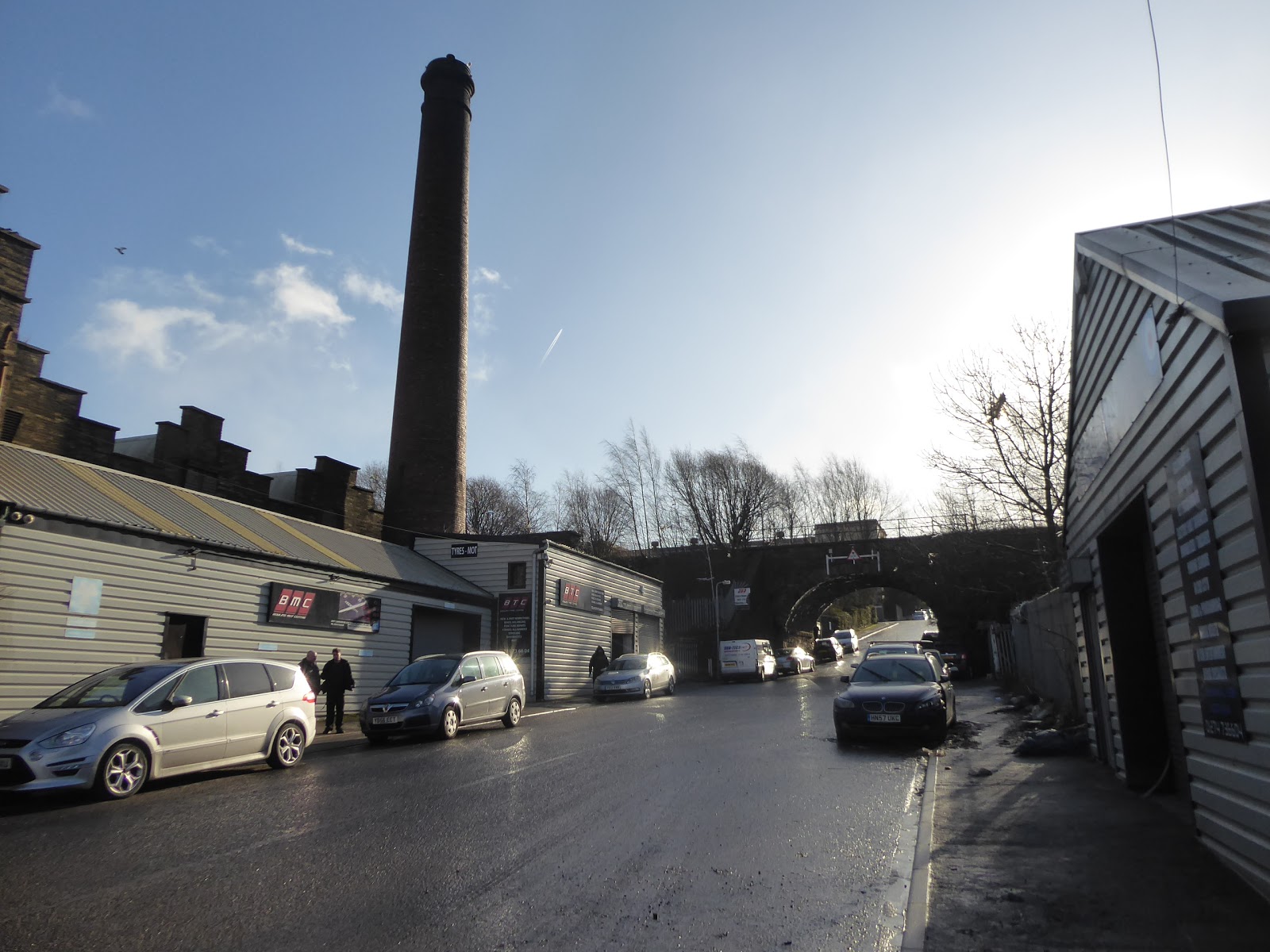
The first few weeks of 2020 proved to be pretty dry by recent standards, so once I chose to take a break from work, the weather found it to be an excellent time to come on strong, with Atlantic Storm Ciara bringing on all the rain, causing flooding issues again over Sunday, causing major headaches for my friends in Calderdale, with rains following to blight all of Monday and Tuesday, where the only outdoors time I'll be spending involves going to the optician to see about new specs for my failing eyes. It's not until Wednesday that things look better and the early season roaming can resume, to pick up the trail that returns us in the direction of the River Calder, emerging at 10.15am under sunny skies again, setting a course south along Bridge Street and past the Leisure Exchange complex to the tangle of the A647 and A650, as beyond these lies the site of Bradford's original station on the GNR lines, Adolphus Street, which only served as a passenger terminal between 1854-67, but endured as a goods complex until 1972, and while its main buildings have long gone, where Wakefield Road now runs, a large section of its plinth endures. We follow this along Dryden Street, passing the bricked up entrance, the platform level access ramp and the retaining walls to the coal drops where small industrial units now dwell, accessing the high level by a flight of steps and passing on through the Essex Street Industrial Estate, where the St James's Wholesale Market resides on the station site, following the access lane out to the A650, which we cross via the subways to emerge by the Gurdwara on the Usher Street corner, where we progress on past the Bowling Park primary school, and elevate among the industrial units on Barnard Road to pass under the Bowling - Laisterdyke line, under one of the many bridges on the alignment Bradford avoiding that's been closed since 1964. We then ascend through what could be the confusing rabbit warren of terraces and semis of East Bowling, but we've prepped a route to lead us up and along Paley, Brassey and Flockton Roads to land us at the top on Brompton Avenue, which leads us to Bolling Hall, one of the definitively oldest houses in Bradford, of medieval, 17th and 18th century vintages having endured on site since the 11th century, famously featuring as a Royalist base during the English Civil War and the siege of Bradford in 1643, and now in City ownership as a museum and library. A fine place for a bit of historic transportation away from the contemporary surroundings as you pace around the gardens, and then continue the trip into the greenery of the past as our route leads us into Bowling Park, Bradford's green lung, high to its south, where we pace through the wild gardens and playing fields on the way over to Parkside Road on the eastern edge of West Bowling.
 |
| The last remains of Adolphus Street station, Bradford. |
 |
| Barnard Road and the bridge on the Bowling - Laisterdyke line. |
 |
| Bolling Hall. |
 |
| Bowling Park playing fields. |
There's some fine illuminated views to the city and to one snow topped hilltop to the west to take in before we delve back into the urban landscape, still ascending to get to the southern crest of the city, with Parkway leading us uphill among the pebble-dashed semis, giving us a fine northern horizon as we pass the open green space just shy of our emergence onto the A6177 Rooley Lane, where our route takes us around the Staithgate roundabout at the top of the M606 and thence onto the A6036 Rooley Avenue, retracing steps from 2017 as the alternative route chops off too large a piece of Greter Bradford. Going this way at least gives us a chance to take another look at the Richard Dunn Sports Centre before it departs the landscape, I assume, and to peer through the gates around Odsal stadium, or the Provident stadium, now disused as the Bradford Bulls are no longer tenants after another testing few years in the Rugby League, and then we move on to fresh paths once we meet the interchange at Odsal Top, slipping onto the A638 Cleckheaton Road, which will carry us for the remainder of today's trip, southbound. It glooms over for a while as we pass Odsal village green, showing up signs of recent rain that have missed us completely, but that doesn't endure as we scratch the suburban edge of the city as we slip downhill, passing the brand new Sedbergh Sports and Leisure Centre, which has surpassed the one up the hill in terms of facilities, but has none of the distinctiveness in the landscape, and then settling into the top edge of Low Moor, by the allotments at the roadside by Holy Trinity church. The wisdom of walking south at this time of year is tested as we try to find some shade to walk in alongside the large band of medium-scaled industries that sit just beyond Bradford's periphery, coming down past the block of numbered terraces and the forgotten graveyard before we come up by the fragments of the oldest settlement and the accrued development that came with the arrival of the railway, where we pass over the new Low Moor Station, by the Transperience site and the top of the Spen Valley greenway, and also look over to the old station sit to the east and the nature reserve that now dwells on the GNR's engine shed's plot.
 |
| The view over Bradford from Parkway, West Bowling. |
 |
| Appreciating the Richard Dunn Sports Centre while it's still here. |
 |
| The Sedbergh S&L Centre isn't nearly as dramatic. |
 |
| The old Co-op, First & Second Streets, Low Moor. |
The road walk then leads past the parades of proud terraces that sit opposite Victoria Park, and into Oakenshaw, which might well straddle two boroughs as it's not immediately obvious where the crossing point from Bradford to Kirklees district lies, most probably where the road name change occurs and the road rises again, where we meet the Richardsons Arms and St Andrews church, taking us inside the loop and away from greater Bradford, even though the smart suburban stretch to the south still feels part it outermost reach. So enter the green space to the south, with Bradford Road leading us away from the city that we will probably be seeing again at the far end of this walking year, tracing the side of the A638 through the open fields that are flanked by the M606 and the old railway line to Heckmondwike and beyond, before we pass the business park on the site of an old isolation hospital and the clubhouse of the Cleckheaton Golf course, ahead of the Chain Bar interchange, where junction 26 of the M62 tangles up with these parallel roads and the A58 in a mess of slipways and flyovers. Trace the path around the island to find the steps up to the severed stub of Bradford Road below the junction, pacing past it semis to resume the route along the A638, as we land in the Spen Valley proper, with ominous clouds passing to the north of us this time as we meet the outer edges of Cleckheaton, one of those towns that's much larger than you anticipate it being, crossing one of our paths to Halifax by Moorend Park and pacing on past the Horncastle inn and the Moorland club before coming upon several mill site in varying stages of their use and re-use, and the former Congregational chapel that's now Aakash's restaurant, and surely one of the largest local party venues too. Meet our other valley transit route as it emerges from the lane up from Mann's Dam bridge, and follow it as the lane snakes its cramped way into the middle of Cleckheaton, taking us past the Commercial inn, the Savoy cinema park and the town hall, before carrying on alongside the main shopping streets of the town centre, to the A643 crossroads, where we recommence our fresh route south, passing the King Edward VII memorial gardens and the local bus station, a quarter that will familiar to anyone who's risked the art of bussing this corner of the county.
 |
| St Andrew's Church, and the Richardsons Arms, Oakenshaw. |
 |
| The 7-way interchange at Chain Bar. |
 |
| Aakash's, in the former Congregational Chapel, Cleckheaton. |
 |
| The KE7 Memorial Park, Cleckheaton. |
Cleckheaton gradually peters out beyond there, the terraces and industrial sites reducing down past The Marsh inn to meet a definite gap between it and neighbouring Liversedge, a town with its own sort of identity crisis, as we meet the River Spen as it emerges from below the road, and we elevate up as the road becomes a dual carriageway, as it runs past Royds Park, where we randomly hopped off a bus to walk the Spen Valley Ringway back in 2012, and continuing along this trajectory as we run past the Spenborough Fitness complex and the Littletown JI&N school, while pondering whether this town has a recognizable centre. We didn't see it when we came this way in 2014, having burned a path past Christ Church and out of Knowler Hill road, and the path along Bradford road doesn't feel at all familiar as we make our way past the Old Oak inn and go with the narrowing and twisting lane as it passes the job centre and comes up to the A62 Leeds & Huddersfield Road corners, and there's no heart of town to found here, and we can only conclude that the 20th century erased it somehow, leaving a vaguely defined location between two much more identifiable towns. The rising lane leads us into Heckmondwike, where signage clearly indicates is arrival among the mass of factories that dominate the roadside landscape ahead of Algernon Firth Park (which shared a benefactor with the institute of Pathology at Leeds General Infirmary, interestingly), and our subsequent arrival on Westgate by The Green, which is certainly the town centre, as it has a small shopping centre and well defined parades of stores, as well as the bus-stand terminal and the familiar crossroads where the Memorial Fountain Clock can be found. That gets us back to a familiar bit of terrain, as we have to ascend out of the Spen Valley on the rising hill of High Street, up past the site of Heckmondwike Spen station and the Grammar school, and after keeping ahead of the weather for so much of today, it feels like our luck is running out as we get to a more exposed altitude as heavy cloud blows over with a forceful accompaniment of wind, giving us some chills as we look back to our only real valley views of the day, while still getting enough momentary sunshine to illuminate the Upper Independent Chapel and its school, elevated over the town on its prominent perch.
 |
| Royd's Park, Liversedge. |
 |
| Bradford Road and the Old Oak, Liversedge. |
 |
| The Green, Heckmondwike. |
 |
| The Old Fire Station, High Street, Heckmondwike. |
At the Junction Inn, we regain a new path with the A638 Halifax Road (not that I can be sure which route it would take to get there, rising on steeply, which is noticeable as the legs start to tire in the cooling air and the trucks heading downhill make ugly sounds as the brake, with us gradually making our way into what I assume is greater Dewsbury, passing the former pub with the Springwell Ales ghost signs on it before we settle onto the weather exposed top of Staincliffe, where we come up to the crossroads by the Crown and the Butcher's Arms inns, just down from the remotely recognizable tower of Christ Church. Start the decline as we pass the playing fields and sports club at the hilltop, and not the weather threatening to come on hard from the west as we pass the Cullingworth Street entrance to Dewsbury and District Hospital, which has taken over quite a large site on this upland, as there's quite a lot or road to pace among the suburbs and the rural and resdiantial outliers before we reach our next familiar corner, past the Old Shoulder of Mutton inn and the end of Healds Road, with signage indicating that we were in Batley Carr, and maybe greater Batley for much of that high traverse. It's all downhill from here though, past the Mormon Temple and the apparently closed Wheelwright Campus of the Batley School of Art, with quite the fiercest and loudest two minutes of weather blowing in as we come past the Dewsbury Gospel church, in the former building of St Mark's, which then blows itself out as quickly as it arrived as sunshine pours through as we pass the Dewsbury Masonic hall at the top of the last descent of the day. It's good to get some brightness as we come down here, past the original and former campuses of Dewsbury Technical college, and also the old Infirmary, which is a distinctly Gothic-y presence on the valley side to the north of the town, ahead of the Bath inn, the Springfield Sixth Form College and the residential conversion of the Spinkwell Mills site, beyond which we meet Dewsbury viaduct, which is passed under to seek the way to the railway station along the side of the ring road, as it's easier than seeking the north entrance to the station via unfamiliar streets, arriving at the main building to seal the day at 2.15pm, just late enough to miss the local service that would have gotten us home in very short order.
 |
| Halifax Road ascending out of the Spen Valley. |
 |
| Staincliffe feels like an exposed hillside. |
 |
| The Dewsbury Gospel Church (formerly St Mark's). |
 |
| The Bath Inn, and the old Infirmary, Halifax Road, Dewsbury. |
5,000 Miles Cumulative Total: 4288.8 miles
2020 Total: 22.3 miles
Up Country Total: 3825.8 miles
Solo Total: 3974.6 miles
5,000 in my 40s Total: 2882.6 miles
Next Up: Keeping on the early season trail while the weather permits it.


No comments:
Post a Comment