12.4 miles, via Hollingworth Lake, Rakewood, Booth Hollings Mill, Longden End Brook,
Thorney Bank, Rag Hole, Piethorne Reservoir, Hanging Lees Reservoir, Cold Greave Clough,
Rapes Highway, Readycon Dean Reservoir, Broad Greave Hill, Haighs Gutter, Little Moss,
Castleshaw Moor, Millstone Edge, Brun Moor, Cabe Whams, Warcock Hill, Carr Clough,
and Netherley.
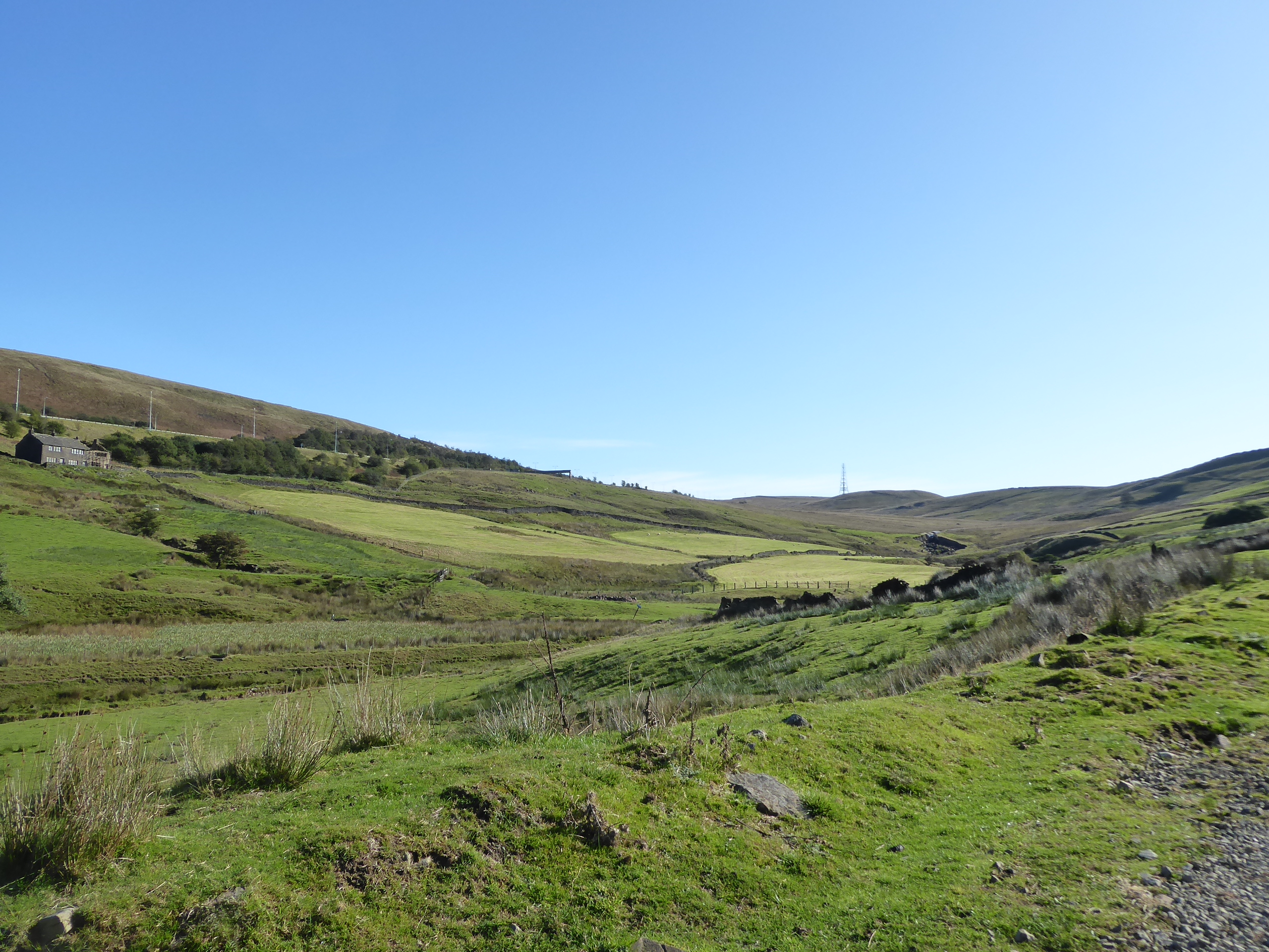
Since we were last out, a whole lot of new lockdown restrictions have been put in place, both locally and nationally, but as there aren't any being placed on non-essential travel, and as I still trust my socially distanced judgment, we're going to continue as planned as increasing Covid infections aren't going to get in the way of me finishing my Spring slate of walks, at the very end of Summer, as the sun threatens to shine down on us, but the turning of the Autumn season means the need for early starts are not necessary now, despite the distance to travel. So me land for our last trip in Greater Manchester for this year at 9.35am at Smithy Bridge station, still a considerable step away from Rochdale in the wrong direction from our route as we set course for our fourth and final trans-Pennine route, heading back up the lane to Hollingworth Lake as the morning sunshine bathes the village in a weird sepulchral tone thanks to the sun being blocked by a single dense cloud in the otherwise blue skies as the uphill path sets the tone for the day. Arriving on the Lake Bank shore of the lane has me surprised how busy it feels for so early in the morning, until you realise that it's nearly 10am and a perfect time for a brew to be taken by the other visitors in the cafes that face the The Beach and the boating club, and we'll pace our way on to continue the circuit that we started last week, by crossing the car park to meet the perimeter path, starting out from the slipway that has been taken over by the local geese and ducks, before pacing east alongside the gardens on the north side, observing that there still seems to be rowing activity going on, despite the lake being officially closed to leisure boating. We are led on below the northern dam, the Lake Bank itself, containing the water from escaping down to the canal and river Roch below to the north, passing the main valve tower as we come around to the Wine Press once again, this time clear of many drinkers as we retrace our path on the eastern bank, over the Hollingworth Bank Dam and on southwards, taking care not to be tempted onto the northern reach of the Pennine Bridleway as it splits off and we carry on down to the edge of the nature reserve, and the beginnings of our route into the western face of the Pennine ridge. Rakewood Road leads us alongside Longden End beck as it flows down from the hills, between the field where the local geese reside in vast quantity and the reservoir's feature campsite, nestled among the low foothills that surround the outlying farmstead and cottages, as we move away from the local tourist traffic, on a route that will have the low sun in our face for a while, towards Rakewood hamlet, the last significant settlement that we'll be seeing in a while as we set course up onto the Greater Manchester face of the moorlands.
 |
Smithy Bridge Road, and the Methodist chapel.
|
 |
Bird life on the Hollingworth Lake slipway.
|
 |
The Wine Press from the Lake Bank Dam.
|
 |
Many Canada Geese, near Rakewood.
|
Rakewood seems to have been home to a couple of mills in its time, with one still intact and the other surely being a redevelopment possibility, with our southbound Pennine Bridleway route leading us onto the rough track of Schofield Hall Lane, which starts our rise under some tree cover, which will be the last of which we see in along while as we are elevated below the M62's Rakewood Viaduct that has managed to hide from view, if not from the ears as it rises over the Longden End brood valley on many narrow piers that seem to thin to support its vast bulk. It's probably one of the local engineering marvels that doesn't get the regard it deserves due to it being a motorway feature, but it marks a neat barrier as we set up a traversal of this side valley, which doesn't offer a straightforwards route uphill to the moors and instead takes a long switchback up the valley, past the rising track up to the Booth Hollings farms and on among the building of the eponymous mills, which don't look to have seen any business in a while, despite being prime for being an outward bounds centre. We'll shadow the M62 as we progress east with Longden End Brook, up to the last habitable house in the valley, the Longden End mill house, surrounded by a protective bank of trees, downstream from the valley that's oft seen from the motorway but isn't a prime walking location, with the clough leading up to the Windy Hill mast, where our previous western boundary was established in 2013 and our cobbled track leads up to the hairpin from where we'll ascend up the southern side of the valley. The climb comes on now as we head on to the southwest, rising below the pylons that we've seen so many times on their trans-Pennine route as we re-scope the route that we just traced at the valley floor, which make both the mill and the motorway viaduct look diminutive among the rising hills of moorland grass as we keep the evolving northern horizon in our sights, across to the southern flank of Rossendale and its wind farms, over greater Rochdale and on to the sentinel of Winter Hill on the far western horizon. Eventually look south as we rise to the first crest of the day, where we cross over the ancient moorland track of Tunshill Lane by the Thorney Bank farm site, and join the permissive track that leads down toward the wooded Rag Hole clough as it leads us south, still in the Roch catchment, but deep into a landscape that is new to me having been unseeable on all my previous Yorkshire - Lancashire travels, around that mysteriously concealed town of Oldham.
 |
Rakewood Upper Mill.
|
 |
Booth Hollings Mill.
|
 |
Longden End clough and the way to Windy Hill.
|
 |
Rakewood Viaduct and the Rossendale horizon.
|
 |
The descent from Thorney Bank.
|
We meet it's major reservoir catchment as we pass the Rag Hole farm ruin, as the valley of Piethorne Clough opens up below us, with its western route giving site of just one tower block to the southwest as if this town insists on keeping itself hidden, beyond further ranks of hills and the intermediate settlements of Milnrow, Newhey and Shaw, while our route turns east, above Ogden reservoir, where the cold winds from the northeast makes it feel like stopping for elevenses is unwise, and a thickening bank of cloud makes it look like the day isn't going to stay warm or sunny fro much longer. Such are the risks brought on by proximity to the Pennines, and making us very happy that there's no rain projection for the day as we carry on along the United Utilities access track as it rises high and wends its merry way above Kitcliffe reservoir and it neighbouring waterworks complex as the surfaces shift from blue to grey and the wisdom of donning the long-sleeved walking gear is felt as the day chills down rapidly, as we carry on to meet the passage across Piethorne dam. This contains Piethorne reservoir, naturally, the largest on in the valley, which the sunshine seems eager to try to illuminate as we pass over to its southern side, beyond the valve tower that could be mistake for a cottage, and back onto the PRoWs that seem to be locally popular despite the conditions and the circumstances as we press east, taking in the last blasts of colour as the surrounding moorland hills are illuminated before greyness takes over the scene, again coming over from the Yorkjshire side, against cliched expectations. Rise with the track as it leads up to reservoir #4 in the valley, the relative puddle of Hanging Lees, which we pass over the dam of as we head back towards the Pennine Bridleway route, having taken a more interesting and less exposed low level route around this valley, getting sight upstream to the fifth reservoir, Norman Hill, concealed away among the grasses of Bleakedgate Moor, which still afford us some sense of location due to the sight of the Windy Hill mast and the passage of the A672 above. Hit the rise out of the valley as we get back on the national trail route again, an ascent of around 100m that feels pretty significant as we push on to the first major watershed of the day, getting a good look back to the southern edge of contemporary Lancashire as we go, uphill alongside Cold Greave clough and over the catchwater drain that feeds the nearby Rooden reservoir off to the south, the sixth and final on in this valley, at the outermost reach of the Roch catchment, which we've done our best to familiarize ourselves with over the last month.
 |
Ogden reservoir.
|
 |
Kitcliffe reservoir.
|
 |
Piethorne Reservoir.
|
 |
Hanging Lees reservoir.
|
 |
The Rooden reservoir catchwater.
|
Despite the altitude, at over 370m up, we are right on the edge of farmable lands once again as the track accesses the Bent Heath farm below and we pass over the Roch-Tame crest, just ahead of the route dropping us out onto the A672 Ripponden Road by the Ram's Head inn, just a little way up from the village of Denshaw in the valley below, where we can look south down the western Pennine Edge, down the Tame valley where the railway runs and on to the edges of the Cheshire Peak, way off to the south, with its familiar tops of of Shining Tor, Shutlingsloe and Croker Hill. We need to regain the Pennine Bridleway route as it avoids passage alongside the main road, one which looks a bit too busy traffic-wise to be safely walkable from the West Yorkshire side, as we rise above Crook Gate Reservoir at the valley floor and past the covered reservoir at the roadside as the sunshine tries to make another breakthrough as we join Rapes Highway as it burrows its way down into Readycon Dean, and passes its way over the Saddleworth border as we go. Despite being still deep into Greater Manchester, we are actually back in the historic West Riding as it once occupied a big chunk of the Tame Valley on the 'wrong' side of the Pennines until 1974, so we're already home, after a fashion, as we come up to Readycon Dean reservoir, at the top of this steeply sided valley, still feeding Oldham with water, somewhere off to the southwest of here, and again not too far away from our previous western boundary on White Hill, somewhere off to the northeast of here, and lacking the profile and elevation would render it distinctive. It's pleasing to find that the various routes over the Pennines have brought people out to the moors for a walk, as more parties are met on this passage, taking in a brisk circuit of the reservoir as I do my best to keep the mileage going as it's too cold and exposed to stop, hammering out of the valley and losing the Pennine Bridleway as it splits off, but blazing on over 400m up as we get to an improving view of the Tame valley proper and the Pennine flank to the west of the Black Hill uplands. The altitude of Broad Greave Hill gives us scope to look over the hills on the Tame-Medlock watershed, directing our gaze over Manchester as it sits concealed beyond, making us consider the expanse of the Cheshire plains to the southwest, and to seek a sentinel location to guide the eyes, which we again find in Fiddlers Ferry power station on the banks of the Mersey, which locates Moel Fanau and the Clwydian hills beyond, while the brain tries to penetrate further into North Wales, convincing itself that it can see as far as Snowdonia.
 |
Topping the Roch - Tame watershed crest.
|
 |
Crook Gate reservoir.
|
 |
Readycon Dean, and the Saddleworth border.
|
 |
| Readycon Dean reservoir. |
 |
| The Tame Valley-Cheshire-Clwyd horizon from Broad Greave Hill. |
We need to focus our attention to the immediate locale though, as we descend to meet the A640as it makes its trans-Pennine passage up Haighs Gutter, giving us a much easier road to get onto as we need to keep to its side to head up towards the West Yorkshire border, giving us much less traffic to worry about as the Huddersfield Road seems to have shed much of its usage to the motorway as we rise above the clough that has gouged deep into the moorland soils, on our way up to the western boundary of our walking field, where the Pennine Way makes its crossing. That has us close to our finish line, if we wished to take the path over Close Moss, but we'll stick with the west side of the Pennines for the moment as we join the premier national trail as it rises onto the moorland of the Little Moss, which affords us a northwards view to March Hill and the Buckstones, above the rising of the Colne Valley, while we head away from it southwards, among the spread of moorland grass and down through the shallow clough at the English watershed that leads us onto the elevated path over the eastern edge of Castleshaw moor. Keeping to the Tame Valley side, all the plots to the east are being managed to restore the peat, and thus are to be avoided as we rise to a point where we can look to both the Emley Moor and Winter Hill masts on either side of the Pennines, as West Nab and Black Hill/Holme Moss arrive on the local horizon, and the high points of both Manchester and the Trafford centre appear to the further southwest as we come down to the downstream view at the corner named Northern Rocher, where the Peninne and Oldham Ways separate, and we rise to Millstone Edge. This long moorland edge, above the Tame Valley offers a grand view over the landscape that we had hoped to get into during this summer before the pandemic ruined everything, where we can look down towards Broadstone Hill, Alphin Pike and the Greenfield Mast, much of which once sat within the West Riding, below this ridge of gritstone outcrops and boulders which spill downhill towards the Castleshaw Reservoirs, to the west of the Standedge ridge, which features large on maps but is pretty hard to suss out on the ground. Despite the views, and the relatively easy going on the rough terrain, it's not a place to linger in these chilly winds blowing in behind us, as we make our way above the declining moorlands above the Tame valley, feeling surprised that there is much foot traffic up here too, on what I'd assumed would be my remotest day of the year, as others seem apt to be up here above the gritstone too as we pace on to meet the Dinner Stone and the Millstone Edge trig pillar, at 448m up, the day's summit, if not that of this particular hillside.
 |
Haighs Gutter and the Huddersfield Road.
|
 |
The Colne Valley headwaters from Little Moss
|
 |
The Tame Valley revealed from Castleshaw Moor.
|
 |
The Castleshaw reservoirs from Millstone Edge.
|
 |
The Dinner Stone and the Millstone Edge trig pillar.
|
The panorama from the trig is pretty fine, giving scope of West Yorkshire past and present, and we're gifted with a sunburst to enhance it too, as we again sit just above the cultivation limit, above Higher Standedge farm, and the roads that twist around the valley head just as the sun bursts through to make its final attempt at warming the day as we carry on going to maximise the illumination, gradually working ourselves away from the Standedge edge, and following the rough path as it leads us on to meet a herd of moorland cows, which i always assume are the exact same bovines, regardless of where I meet them. We actually drop off the bottom of the OL21 plate here, and need the OL1 Dark Peak map to negotiate our way down through the plots of Brun Moor, for some context at least, with the reservoir and car park on the roadside obvious, but the Pennine Way still taking a mighty sort of wander to get there, via quarry tracks and some disorientating lacks of views before we emerge to meet the A62 at the south end of the Standedge cutting, where it gouges its way over the watershed, and we land by a wall that offers enough shelter for lunch. It's late and takes a quarter hour, but we're freed from the wind for the duration, just up from the canal's reservoir that feeds the tunnel that's directly below us, to be tracked another time as we move away from the comings and going's on this western side and make a break for home by rising with the path that leads above the trunk road over Standedge, before taking one of at least three old roads over this moorland, directing us towards Deer Hill - West Nab and below the sharp edge of Pule Hill. That's a modest hill that ought to have featured in this year's plans which have to settle for a remote viewing as we head east, with it providing a dynamic backdrop to the sight of the heart-shaped Redbrook reservoir, another canal feeder that doubles as another remote boating lake on the moors, as we carry on down to the moorland road's missing bridge at Cabe Whams, where the Pennine Way rises off to the south, with a surprisingly large number of people on it, for this stage in the day. We're back on the eastern side of the English watershed but still have one last rise to make before we can return to the Colne valley, as our track rises over the barrier of Warcock Hill, or rather cuts a path through it to prove that even the old roads made feats of engineering that we wouldn't expect to find as we pass north of the moorlands marked as only Bobus on all maps, a cryptic nomenclature that renders those rise to the south that bit more mysterious as they fail to land among this season's routes.
 |
The Tame valley from Standedge edge(?).
|
 |
| Brun Moor and the reservoir. |
 |
The Standedge Cutting on the A62.
|
 |
Redbrook Reservoir, and Pule Hill.
|
 |
The old road passes through Warcock Hill.
|
We land above the upper reach of Carr Clough as it starts to guide us downhill, past the sharp end of Pule Hill and down, with the old road features gradually diminishing before we are called on to make a traversal, as there's no indication of it having been bridged despite its route being speculatively obvious, and that's an unfriendly descent and climb to make, as the path seems to be in the midst of repair work with stakes and withes littering the scene ahead of us clambering up to Mount Road, another of the superseded routes out of the Colne Valley. We cross to Old Mount Road, as it skirts the eastern side of Pule Bents, which is scarred by quarrying in its past, with us getting a completely traffic free route that rises us to views across to the Wessenden valley and the high hills to its east, providing a sight line over the golf course and on to Butterley reservoir, before we descend to tree cover around Bowser farm, which finally takes the wind off the day after 4+ hours of exposure to it, ahead of the steady descent towards Marsden. The hills to the north of the Colne valley finally have us feeling close to home, despite never being that far from it despite the extensions made to our western boundary, as we meet habitation for the first time in ages as we hit the hamlet of Netherley, home to the Puleside WMC, at an odd remove from most industrial settlement, and not even convenient for the runs of semis reaching up Mount Road below us, so maybe it was sustained by the farmsteads with a view up here instead, of which there are more than you might expect. As we descend towards Marsden from another angle, looking down to the Bank Bottom Mill complex and across to the New Mills, with the town spread along and up the valley side between them, it's noted that in the last couple of years that we are still to push our boundary beyond this town, as it remains a focus point at its southwestern edge, and will continue to do so until we return to the Greater Manchester moorland passages, meeting it by the Wood Top terraces, ahead of landing on the A62 across from St Bartholomew's church. Thus Town Gate leads us down to Church Lane between the current and abandoned graveyards and back into our experience field, thence over the River Colne and past the western edge of the town, which seems a lot quieter now that the pandemic has put paid to the crowds of pub-crawlers, rising back up Station Road beyond the Railway hotel and over the Narrow canal to seal the day at 2.55pm at Marsden station, ending our escapade through the walks we'd hoped to burn through in the March to June window, before we were robbed of 12 weeks of Spring, and all the mileage over the border that I'd planned for the Summer.
 |
The decaying passage over Carr Clough.
|
 |
Deer Hill & West Nab, over the Wessenden Valley.
|
 |
The Puleside WMC, Netherley.
|
 |
Arriving above Marsden and Bank Bottom Mills.
|
 |
Towngate, Marsden.
|
5,000 Miles Cumulative Total: 4655.3 miles
2020 Total: 388.8 miles
Up Country Total: 4192.3 miles
Solo Total: 4328.7 miles
5,000 in my 40s Total: 3249.1 miles
Next Up: Colne to Hebble, if the season is permitted to progress any further...
~~~
Pandemic Thoughts: September
If we are honest with ourselves, if we'd been asked a few months ago where we might hope to be with regards the pandemic situation at the end of September, we'd all have been a little hopeful that we might have gotten a grip on it, with the infection rates staying low and the possibility of contagion retreating into the background, but our pessimistic sides would have more probably have expected us to be where we are now, looking at a steadily rising infection rate, doubling steadily over the weeks and starting on what looks like the same exponential rate that we saw back in March. You can be sure that HM Government was feeling much the same way as the month opened out with them speculating on who was going to be paying the tax bill for the furlough scheme that was due to end in October, while also trumpeting the fact that they were looking to be able to be turning over 10 Million Covid tests, per day, in six months time, while now they are struggling to come up with a scheme that will ensure many people receive wage coverage for potentially another six months, while also seeking new streams of revenue to pay for it, and trying to prevent the possibility of mass unemployment. The testing projection seems particularly hilarious when measured against the fact that the NHS test and trace system (run by a private enterprise, incidentally) has been consistently mocked and criticized for its incompetent and ineffective operation since its initial launch in July, to the point that it needed to be full relaunched this month, but as it's app-based that's pretty useless for me as one of the folk who still resists the ownership of a smartphone, so I'll have to fly by the instincts that have carried me along so far. Still, being an NHS employee ought to have me able to get tested a relatively short notice and inconvenience, if I were to become symptomatic, and these regular hot flushes that have tested me through this month gained a persistent cough or effect on my sense of taste and smell, which hasn't happened thankfully, though the promise of getting a work-sponsored antibody test seems to have come to naught, as no date has been offered to me since applying for one more than two months ago. Also along the way, it's been good to see a new roll out of health advice, as the 'Hands, Face, Space' directions are certainly more clear and explicit than the last lot, especially the 'stay home if you feel ill' plan that was really a bit off the mark when the incubation period is two weeks long, but still seem to be missing the most important direction of 'avoid all unnecessary social contact', as if it's expected that people can't remember more than three instructions at a time, which is probably true when there are seven on the list for hospital employees and I'd be hard pressed to recall them all if put on the spot.
We close the month at a particularly discouraging spot, as the trajectory of the month seems to have been pointing towards things getting worse right from the outset, with the infection rates heading into their gradual climb while HM Government still insisted with pressing on with its schemes for a return to normality, such as sending kids off to university as if they'd never heard of 'Fresher's Flu' being a thing or being aware that a bunch of youngsters getting their first taste of independence are not going to sequester themselves in a new town with new company (I'd like to think my cynical 1993 vintage self would have had none of such an idea, and would have chosen to defer instead). There's also the pressure for employees to end the large scale working from home and to get people back into their offices, despite the fact that the reasoning to send people out in the first place was due to the lack of space to ensure effective social distancing, and the lack of necessity of gathering people en mass in a public health crisis, as if the needs of ancillary industries still need to be met ahead of those who work in environments that could expose them to greater risk. And then, there's the issue of sending kids back to school in bulk, with no contingency for remote learning or staggered lessons, as if it's been the absolutely immovable plan right since the pandemic landed back in March, and in Leeds, at least, we have schools reopening in the same week that the alert status of the city has been raised, proving that the infection rate is on the way up even before thousands of children are thrown back into the mix, an event that many of us speculated might kick off a second wave of the Covid crisis. Just like I said last month, everything is being forced back to normal without any apparent planning of willingness to hesitate or delay in the event of things going wrong, a course that we appear to be on now, while those who are supposedly in charge act like they've been completely blind-sided by events and don't seem to have an immediate response to make, so as we expect a return of some kind of lockdown or restrictions being put in place post haste, we have the 'rule of six' announced to limit social meetings, and a promise to close pubs early, as if that will make a huge difference. At least the government scientists seem to be having none of it, re-emphasising the fact that a limited national lockdown would be the only reasonable course of action to lower the infection rates, and to stop putting economic concerns ahead of public health matters, because you don't have to look too far back into the past to see that lockdown did work, as shutting everyone away for dropped a catastrophic infection and death rate down to the point that we have managed to have an almost normal passage through the Summer.
Once again, we find ourselves wondering why worst case scenario planning seems to be so far back in the thoughts of those who would govern us, and why so many people seem so determined to live their lives as normal in such potentially dangerous times, and thus those of us who worked through the entirety of lockdown and beyond find ourselves watching as it looks like all the hard work of the Spring is getting undone, ruined by the actions of those who don't recognise, or acknowledge, the risks, or simply don't care about them. Ultimately, we find ourselves taking an attitude of self care and preservation, as we finally feel like we have a proper feeling of what this pandemic is all about, like it's a serious case of influenza, but one for which we don't have any preventative measures to take against it, and this with any infectious disease, we just need to limit the amount of social interactions we make, while hoping that those who are most vulnerable to the risks are able to continue to shield themselves as we slip into Autumn. So, it's with this attitude that I traveled away for my break at The End of Summer, riding the trains down to Leicester, despite the restrictions at both ends of the journey so that I could spend the week with Mum, claiming both the social bubble and aiding an elderly relative rules as a valid reason for doing it, and also travelling because she hasn't had a house guest of any kind since February, and the window of plausibility for doing so so seems to be shrinking as we speak, so doing it now to give her the smallest feeling of familial normality seems essential. It's not like we even have grand plans of what to do with our time, as she only really needs aid with sorting a few things out since a bout of redecorating ended in March, minor tasks like hanging some new curtains or moving furniture back to its proper locations, or clearing away more of Dad's possessions that we'd planned to be rid of, but have been unable to sort because of the circumstances. It's just a good feeling to be able to give her some company as we watch the seasons shift, very literally as three days prove warm and sunny enough to have lunch in the conservatory (apologies for just how middle-class that sounds), before the gloom and chill kicks in, while also taking the opportunity to go out to take lunch and tea at a restaurant and garden centre in the county, where the local restrictions aren't as harsh as the lockdown that continues in the city, giving us both the smallest of expansions of our horizons while it feels most safe to do so. She's otherwise well, still keeping in touch with her church congregation via a Zoom routine of services, quizzes and coffees, but not really looking forwards to Autumn as the seasonal shift robs her of the gardening options that had kept her busy through the preceding seasons, and she just feels glad that my visit didn't seems as brief and transient as it was, only five nights away, before I head away again, as we hope to remain on our paths that have so far kept us healthy and mostly sane, while still carrying the hope that we can reunite at the end of my walking season in November, only six weeks distant.


No comments:
Post a Comment