16.3 miles, via Yews Hill, Crosland Moor Bottom, Paddock (Foot, Brow & Clough), Royds Hall,
Cliff End, Longwood (& the Edge), Salendine Nook, Mount, Outlane, Gosport, Stainland Dean,
Firth House mills, Knowsley Hill, Ringstone Edge reservoir, Withens End, Booth Wood,
Pike Clough, Rishworth Moor (Pike End, Blackwood Edge, Dog Hill, Green Withens Edge,
Flint Hill Drain, Rishworth Drain, & Old Packhorse Road), Blackstone Edge Moor
(Aggin Stone, BSE Pasture & Roman Road), Lydgate, Gate House, and Durn.
September arrives with us still deep in our schedule of Spring walking plans, and with me wondering if this garbage Summer is actually going to offer us something that resembles The End of Summer as we shift over into markedly cooler days and lower angles of sunshine in the shifts of the season, not that it really matters as I have a slate of four walks to get into that had been intended as a prelude to a Summer of burning as many Trans-Pennine route as possible between West Yorkshire and Greater Manchester, a plan that we can only nibble at now before we start to run out of long enough days, a mere month in the future. So our routes Over The Top for this month start in the vicinity of greater Huddersfield, still travelling early as we alight at Lockwood at 8.15am, with the day promising to be chillier than it is bright, landing on the Holme valley side again, though just barely, as glimpsed as we pass under the railway for the downhill view before starting off northwards, up Winton Street to make our way over the top of the terrace-clad Yews Hill, along its eponymous top lane and down Moorbottom Road before splitting onto the footbridge path that leads back over the railway, revealing the north portal of the tunnel that penetrates it. We then move on into the Colne Valley through the tangle of terraces which lead us out to the bottom of Blackmoorfoot Road, a familiar corner of Crosland Moor Bottom, crossing the A62 junction by the Griffin Hotel and diving downhill via Birkhouse Road to meet the Narrow Canal, by the IronWorks flats, and the River Colne, both crossed in short order among the Paddock Foot industrial zone and under the shadow of the iron spans of Long Royd viaduct, and our long ascent away starts as we rise up Shires Hill road to meet Market Street, a major suburban lane of West Huddersfield. We seek the interesting green lanes and split levels of this town though, so we quickly slip away down Brow Road, which is Colne Valley leafiness incarnate beyond the Wren Street corner, with the few suburban arrivals getting that countryside feel in the heart of the town, concealing that fact that it was once wholly terraced on the length of its sweep around to the rise over the railway line to Manchester in its deep cutting, with us progressing on up Clough Lane to the Paddock Clough traffic island, home to both the Angel and Royal Oak inns. Get back onto a clear trajectory as we rise onto Longwood Road taking us on through the terraces and house of the Royds Hill estate, past the old Co-op store on the Quarmby Road corner and on up through the runs of terraces that sit above the valley side, before we drop some through the corner of Cliff End, which gives us some upstream views towards Scapegoat Hill, and is in usefully close proximity to the former Longwood & Milnsbridge station before we are angled along Vicarage Road, and into the dry valley of Ballroyd Clough.
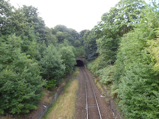 |
| Yews Hill Tunnel, Lockwood. |
 |
| Longroyd Viaduct, Paddock Foot. |
 |
| The Angel Inn, Longwood Road, Paddock Clough. |
 |
| Viagarge Road and the dive into Ballroyd Clough, Cliff End |
Despite the drop and climb around the hairpin between the Quarmby and Longwood cliffs, we don't get good views thanks to the tree cover, and thus we rise to Longwood proper needing a panorama or two, which we can find once we've passed through the Thorn Hill terraces, past the War Memorial corner and the path up to the Pulpit Tower by rising sharply up Bull Green Road, which amazingly has a residential aspect of multiple vintages as it rises above St Mark's church and offers views across the Colne Valley, over Leymoor and Golcar to the high hills off to the south, clinging to the slope below Longwood Edge. Views down to Parkwood Mills and across to Scapegoat Hill fill the horizon ahead as we rise up to the Longwood Edge Road, a rough track that pulls back a bit from the cliff edge, shadowing the school playing fields on the hill's flat top that has resisted further development, aside from the building that someone saw fit to develop as a venue with a view, which looks rather out of business to me, and there's chill breeze blowing up here, too, a the day takes on a discouraging hue, though even at this early hour we've found another path popular with those who would exercise their dogs and themselves. Meet the proper roads again at the ascending Gilead Road corner, where we pass Salendine Nook's sole run of terraces ahead of the suburban bungalows that have crammed up to the edge road, where we take the pavement that gives the best view over the Longwood Brook side valley, ahead of the run up towards the A640 New Hey Road at Mount, the dual carriageway red route out of town to the west, and the absolute suburban limit of Huddersfield too as we join the noise of the traffic for a while as we pass over our early season route in the subway route below us. This corner of the town seems to be one of those inexplicable locations where routes seem to pile up, having been in the vicinity twice before, and that's not even considering the trans-Pennine route to Rochdale that probably won't feature in this year's remaining weekends, as we are drawn on towards the Outlane Roundabout, where the Kirklees Way brought us in 2014, where we pass over the M62's Junction 23, which slips us over the Colne - Blackburne watershed again, giving us a look up towards Longwood Common before we dive down with the dual carriageway to the edge of Outlane itself, by the White Swan Inn. Stick to the main road path, as high points to the north peek over the horizon, following the trans-Pennine turnpike as it leads on through the village, that's part rural outlier, part suburban retreat and part last place to fortify travellers for the route over the moors to Lancashire, which still has a lot of flavour to it as we roll in past its modest church, St Mary's, the orphanage that is now the Old Golf House hotel, separated from its course by the motorway, and enough old cottages and terraces to please the soul ahead of the Waggon & Horses inn (that extra G being a distinct source of spelling curiosity for me).
 |
| St Mark's Longwood and the view to Crosland Moor, from Bull Green Road. |
 |
| Scapegoat Hill and Parkwood Mills, from Longwood Edge. |
 |
| Salendine Nook's run of terraces. |
 |
| The Outlane Roundabout. |
 |
| New Hey Road, Outlane |
Turn on to Stainland Road, which takes us past the suburbian end of the village, and into Calderdale borough right in the middle of it, skirting the wooded chine at the head of Gosport Clough as it flows down towards Holywell Beck, ahead of us departing the B6112 by slipping onto Forest Hill Road as it leads up past Gosport House, the remnant of the mill complex that has been brown-field redeveloped over the years, and thence out of the village past the New Inn, as we note former railway goods vans in a number of local fields. There are smart country retreats and the odd terrace or tow clinging to Forest Hill road as it perches on the bank high above the branches of the Blackburne valley, giving us a look downstream beyond Sowood as we wend our way on, below the turbines on the northernmost reach of Crow Edge, and passing the Dog & Partridge inn before we start our downhill dive into the main body of the valley, as we seek another traversal route across it, even further upstream than before. The high fields of Stainland Moor fall away as the lane drops downhill quickly, making us glad that it's not a popular motoring lane as we unpick the evolving views, gaining an immediate impression of our uphill passage on the western bank as the eye leads up to the pylons and Ringstone Edge reservoir, while also looking downstream to the wooded cleft between my prior route across the valley, with the Sonoco Plant among it, while also scanning the horizon view from Stainland across to Barkisland, and wondering why the upstream views are so relatively poor from here. Hit the Stainland Dean road as it dives down to the valley floor, past the former mill managers' houses and arrive among the Firth House Mill site, which has been mostly demolished to be replaced with a rather overly manicured little enclave which may retain some features of the paper and woollen mills, or at least reside within its former footprint on Black Brook, beyond which we rise again on the twisting and cobbled rise of Steel Lane, one to challenge anyone who insists on following their sat-nav regardless of good sense as it pushes us steeply uphill around sharp corners past the Penny Hill terrace. It's quite a view to regard looking back, showing the depth of the valley, as we seek the route uphill via the ridge of Knowsley Hill, found by following the driveway up to the Park House farms, and then having to field walk it, up beyond the suburban styled house and arrested rebuilding works on those sites, as we follow the right of way via an old lane that has disappeared from the landscape, drawing us up to the gardens of Firth House farm itself, where I have to be directed to not pass through the yard after alerting the dog that seems to be there for the purpose of snaring stray walkers, and getting them to use the deviation route instead.
 |
| Gosport House, Gosport Mills (former). |
 |
| The Holywell Brook valley, from Forest Hill Road. |
 |
| The Upper Blackburne from Stainland Dean. |
 |
Black Brook at Firth House Mills.
|
 |
| Reverse view over the Blackburne from Park House. |
The driveway rise beyond is accessible enough though, with the views shielded by a thick coating of conifers all the way up to the view that emerges above Banquet House farm, which doesn't quite have the look that its name suggests, and the way up to the Blackburne - Ryburn watershed awaits beyond, as we turn a couple of corners on the steep rise up to Scammonden Road, where we were just last week, with the rise up Moor Field Road directing us up towards Ringstone Edge reservoir, below its eastern dam, with a fine view over the upper Blackburne valley behind us. Land on Saddleworth Road and feel hopeful that the shifting clouds to the west are suggestive of improving weather, passing over the B6114 by the waterside wall and joining Withens Lane as it skirts the southern edge, passing the reservoir house and heading over to the Ryburn side, giving us a good look across its western dam that forms a cistern between the Ringstone Edge Moor and Withens End uplands, following the catchwater drain that feeds its bottom corner, where embossed ironwork indicates it origins in sating 19th century Wakefield's thirst, ahead of touching our previous path over here. That's the last route well be touching from this past season though, as fresh miles lay ahead from Withens End Road, where we can look to the explored terrain around Rishworth and the upper Ryburn branch, before our destination reveals itself ahead, the mass of Rishworth Moor rising over the Booth Dean valley, above the cascading dam of the eponymous reservoir, and across from the M62 crossing the Pennines over the bleak expanse of Moss Moor to the south of it, a grand sight to see as the sunshine re-emerges. There's a lot of descending to do to get to our moorland target, though, taking us downhill on a slick track past some farmyard chaos to meet Moselden Lane as it hugs the top edge of the woods of Booth Dean Clough, a lane that's too narrow for the riders and traffic that seems to use it despite the fact it really doesn't go anywhere, shadowing the motorway at a remove and not offering a dear indication of where a footpath descent into the deep valley deft starts thanks to the signage being missing, which becomes apparent once we've walked past it by some distance. Locate the right route, which doesn't feel very well used, angling us down a field and into the woods, crossing over a cascading stream before we land by an seemingly ancient footbridge over Booth Dean itself, beyond which ruins of the Booth Wood paper and cotton mills reside, hidden from view below the tree canopy, with the path squeezing between the high wall remnants of the surviving buildings and up a long flight of steps that seems to be rapidly decaying under moss and balsam, as if nature seems determined to reclaim the site before its rural redevelopment potential is discovered, like a Mayan ruin disappearing into the rainforest.
 |
| The rise up Moor Field Road to Ringstone Edge Reservoir. |
 |
| Ringstone Edge Reservoir from the West. |
 |
| Rishworth Moor lies ahead, beyond Booth Dean. |
 |
| Moselden Lane, above Booth Dean Clough. |
 |
| Among the ruins of Booth Wood Mills. |
Emerge onto the Oldham road, by the Booth Wood hamlet, not emerging from the mills driveway like I'd expected, so paces eastbound along the A672 have to made, another trans-Pennine route that has been sadly dropped from this year's schedule incidentally, following it below the looming plantation and around to the Booth Wood inn, where we start our break for moorland altitude, finding that one path behind the Grove Cottages that has gotten horribly overgrown on the way up to the steep field walk above, which leads us to our lunch spot, where the gloom over the valley has returned. An old farm lane between stone walls, with a gate that is notably sealed at both ends, leads us onto the high apron of fields around Rishworth Moor, taking a rather overgrown and marshy route between the Turner Top farms before we meet a sounder footing on the driveway, like this route isn't one any normal walker uses, as it leads us to Pike End Road, where a quarry track or two could be taken onto the moor, but I choose to stick with the road as snakes its way down the cleft of Pike Clough as it drains the eastern tip of the moorland, and then rises again up past Pike End Hollows and up to the Kit Hill farmstead at its outermost end. It's all a bit of a circuitous trip, as we wander around the high eastern edge of the moor, but coming up this way does give us a grand viewpoint over the upper Ryburn before we start out to moorland altitude, allowing us to look down to Rishworth, with the school's playing fields sitting high above the village, and around to the reservoirs mostly concealed by the spread of trees and fields around their river valley, with the mass of Great Manshead filling the northern horizon as we pass among the high farmsteads ahead of meeting the path route at Pike Law farm. Permissive and PRoW route are both available here, though choosing the former squeezed between wall and hedge seems a poor choice when the latter goes straight through the yard, finally getting us onto the moorland at Pike End with a sole waymarker directing us west along the northern flanks of the moor among the various ridged paths that once served the quarries on this side, with no clear route to pick from, aside from rising above the New Laithe farmstead and up towards the only rocky quarry scar on the moorside, while notionally aiming at the Dog Hill upland, far ahead of us. Getting site of the moorland wall with the ladder stile over it indicates that we need to get climbing a bit more swiftly, so we pick out the trod that ascends most rapidly, elevating us to the moorland edge and the full force of the breeze from the west, so my windcheater is donned to make the long passage over Rishworth Moor when we meet the wall, right next to our previous passage route over here, cresting the moor edge and down over Blackwood Common on an infamous late season route choice from 2013.
 |
| Booth Wood hamlet, Oldham Road. |
 |
| Ascending the notional walled path up towards Turner Top, |
 |
| Pike Clough, Pike End. |
 |
| The Upper Ryburn view over Rishworth. |
 |
| The ascent of Pike End from Pike Law, above New Laithe. |
 |
| The way ahead on Blackwood Edge. |
It's grand to still be in West Yorkshire and still have so much distance to travel over untraced paths ahead, and so we set off along the path that shadows the ditch atop Blackwood Edge, with the moorland grasses being decently short and the ground pretty well impacted as we start our long and gentle rise towards the moorland top, a rise of only 80m or so, but one that will feel much longer as our immediate surroundings offer little of excitement to see, aside from the sheep who sit far from the path, and the evolving north and eastern views that develop as we rise. The moorland crest is gradually approached, with Moss Moor Edge rising to the south, with the drone of the motorway adding to the moorland ambiance well ahead of the M62 becoming visible, and at the second waymarker we meet the clear path that splits off the Blackwood Edge Road route, and rises dirctly to the top of Dog Hill, an ascent that I'd scouted on Google maps to ensure that it was viable, which starts our long push uphill, not a difficult climb by any means but a long and unyielding one. It's another reminder why trackless moor walking probably isn't for me, and it's only a quarter hour drag to ascend 50m, but it feels much longer, with the reverse horizon view to the path just travelled expanding, as well as the Windy Hill transmitter appearing to the southwest, along with the sunshine breaking the gloom up again and a runner and his dog burning me off on the summit approach, which we finally attain at 435m up, hitting the trig pillar and admiring the horizon view that is one of the best secret ones in Calderdale. It's better than the one from Manshead, which seems dwarfed off to the north despite being only 18m lower, and offers a first look to Blackstone Edge too, off to the west, as well as looking across towards Stoodley Pike and feeling the proximity of Lancashire beyond, and we'll not linger here in the teeth of a breeze, taking the descending path that directs us down towards Green Withens reservoir, the body of water in the heart of Rishworth Moor with its own sailing club in it, which cannot be seen from any of the road passages over the Pennines. We'll not be getting that close to it, as our path route, which is stickier and vaguer on this side keeps us relatively high up, above its catchwater drains and tracing the top of Green Withens edge, which falls away to the south and keeps us elevated, on a path that is navigated by dead reckoning. It does draw us up over the middle hill of the moorland, Cat Stones or White Hill, depending on which side you view it from, giving us another 360 degree horizon as we run over its 434m top, before dropping on its southern side again, before we run through the only bit of challenging going on the way down to meet the moorland drain that runs around the flank of Flint Hill, not feeding the reservoir below but instead running westwards, along a path that the local sheep seem to have taken up residence on, and which also seems to have collapsed in places quite a while back without Yorkshire Water feeling the need to repair it since.
 |
| The waymarker indicates the climb to Dog Hill. |
 |
| Upper Booth Dean and Moss Moor Edge. |
 |
| Dog Hill's 435m trig pillar. |
 |
| Green Withens Reservoir, with Windy Hill mast and Blackstone Edge. |
 |
| The Flint Hill catchwater drain, with sheep. |
The ongoing route, which is back on the permissive path we started with, gradually swings us away from the Booth Dean - Moss Moor - Windy Hill valley side, taking us around the lea between the Flint Hill and Blackstone Edge uplands, and draws us around towards the headwaters of the Upper Ryburn once again, revealing the parade of pylons over the moor ahead of the uplands we traced earlier this summer, coming up to the point where three catchwaters combine, to flow towards Blackstone Edge reservoir in a deeper and more secure channel, which our route continues to follow. After the solitude on the moor tops, it's a surprise to find two walking parties out here, especially as the best of the day has noticeably lapsed, both setting off into the moors as we seek our way west via the Old Packhorse Road, which isn't as obvious as you might hope as it rises up from the A58 and on over the shoulder of Blackstone Edge, forcing us onto a sharp turn and a rather conjectural route uphill beyond the drain, presenting softer and muddier going than anywhere on the open moor did, when maops all show it as a clearly defined route uphill. You could convince yourself that it's not a path at all in places, as the trod is extremely vague, before a firm surface of stonework and ancient road base appears to give it some clarity before vanishing into hags of blasted peat for a stretch, and then reappearing again, which makes for some frustrating going on the rise up to the boundary of West Yorkshire, with the way to Lancashire coming as the path tops out, over 450m up (higher than the day's actual summit top) and across the English watershed, landing us by the Aggin Stone, the ancient waymarker on the boundary of our field of walking experience forged back in 2013. The reveal of the western side of the country is a grand one, revealing Manchester in its plain off to the southwest, and the southern flank of Rossendale to the northwest, with the tops of Winter Hill, Longridge Fell and Pendle hill peeking above it from much further away, while the Roch Dale opens out ahead of us, with its town, and notable reservoir, at it heart, and that's the direction we'll be heading down, on the steep and cobbled 'Roman' Road, shedding height rapidly as we head down over the turf of Blackstone Edge Moor (or Pasture), not envying those who've chosen to come up the hillside this way. Pass over the Broad Head drain, the other one that feeds Blackstone Edge reservoir from these high hillsides, while aiming ourselves at the apex of the sweeping curve of the A58 as it takes a slightly more manageable route over the Pennines, taking a steady pace downhill as the knees start to feel tested, watching the horizon diminish as interest is kept up by looking back to the high cliff of Blackstone Edge as it retreats above us, as our path route deteriorates, losing its surface and coherence, before ceasing to even resemble an old road as we push away from the contemporary roadway on a minor footpath, as it passes to the north of us.
 |
| Alongside the Blackstone Edge reservoir drain. |
 |
| Ascending the Old Packhorse Road. |
 |
| The Aggin Stone and the Roch Dale reveal. |
 |
| Looking up the insane pitch of the 'Roman' Road. |
 |
| Blackstone Edge and its moor / pasture, from the west. |
So it's hard to tell if the old road route came down here or not as we pass off the moorland and down alongside the more tended fields of Blackstone Edge Fold, wandering among the undulations of various old quarry workings, and over the upper branches of Red Brook as they flow to the west, suggesting some vintage engineering that's not so visible to the casual eye these days, beyond which we finally meet a maintained path, landing us by the rural Lydgate terrace, the first sign of habitation that we've seen in hours, and our first residential point of contact with Greater Manchester for the year. From here we drop onto the Old Blackstone Edge Road, the middle vintage route of the trip over this corner of the Pennines which I'd figure is the old turnpike, and it's definitely rare to see three lanes pile up like this as we join it to take us to the town beyond, passing the Lydgate Mill site and passing over the green field rise with the mast atop it, getting a grand look back to the high eastern horizon before we meet the Gate House terraces, flanking the lane at the outer edge of Littleborough. The descending lane beyond seems like a standard sort of suburban residential street, until you notice that every other house seems just that bit more modern and ostentatious than you'd normally encounter, as if half the residents found themselves inspired by watching Grand Designs while having just a bit too much money to burn, and that gives some interest as we drop down to meet the A58 Halifax Road as it sharply merges in by the ancient Windy Bank house, and the almost as old Rake Inn, nowadays a Mediterranean Tapas restaurant. The way forwards leads us into Littleborough proper, among the terraces and suburbs of Durn, according to the old maps, taking us over the Rochdale Canal at Durn bridge, the plausibly walkable Manchester-bound stretch that still hasn't dropped onto our schedule as yet, along a roadside that feels far from alien as we are again on the red route between Mytholmroyd and the Bridgewater Hall that we've ridden along so many times over the years, so getting to the Red Lion corner and the railway viaduct beyond has us not feeling far from home at all, even though we are now far from the border down here. Turn with the B6225 Canal Street as it makes its way alongside the navigation channel and on towards Hollingworth Lake, another well-travelled road, but not one we'll be taking as we are right upon our destination right here, accessible via the subway that leads us to Littleborough station, our first of the 92 in Greater Manchester, or the 160+ including ceremonial Lancashire which ought to keep the legs occupied for a good while longer, concluding the trip a 2.40pm, and having enough time to relax and refresh before the hour long trip homewards, armed with a return ticket because cross-border travel is expensive, and thus future excursion plans need to be adjusted accordingly, not that anyone's actually been checking tickets on the trains for months...
 |
| Lydgate Terrace and the way off the moorland paths. |
 |
| The Gate House terraces, Old Blackstone Edge Road. |
 |
| The Rake inn, on the Halifax Road corner, Littleborough. |
 |
| Littleborough Viaduct. |
 |
| Littleborough Station, my first of Greater Manchester's 92! |
5,000 Miles Cumulative Total: 4612.7 miles
2020 Total: 346.2 miles
Up Country Total: 4149.7 miles
Solo Total: 4286.1 miles
5,000 in my 40s Total: 3206.2 miles
Next Up: A Downstream Route feturing about as much of Upper Calderdale as is plausible.


No comments:
Post a Comment