10.4 miles, via Bank Foot, Park Plantation, Ingleby Incline, Greenhow Moor,
Bloworth Crossing, Farndale Moor, Wares Gill, Middle Head, Dale Head, Gill Beck,
Esklet, Oak Beck Head, High Blakey Moor, Blakey Gill, and Blakey Ridge.
Late Summer Jollies arrive, not a moment too soon, and we're off to stay in Ruswarp, a stone's throw up the Esk Valley from Whitby to operate as our base as Mum and I get in a week of relaxation and I can target some walking on the North York Moors, having trailed the coastal railway path and dropped feet on my OL27 plate for the first time in the Spring, it's time to get onto the OL26 map for the first time as the 20 miles of the Rosedale Railways on the remote High Moors, demand my attention as a complete change of scenery from all my day tripping from home, and not least because I've had them on my walking target list for longer than I can immediately recall. They're not especially local to where we're staying of course, and instead of using the Parental Taxi privileges to get to the start line, we'll catch a train up the Esk Valley line instead, starting out relatively late due to the scheduling of the Sunday services, and already in the grip of warm Summer conditions that we haven't seen the like of in two months, having snared a cheap ride for only £3 and travelling along a line I've seen in part before, having ridden the NYMR section to Grosmont in 2016, and as far as Danby back in 1985 in order to visit the National Park centre (Oh Hi, School Trip Memories!) and thence it's a dawdle into the unknown, beyond the head of the valley and into the catchment of the Tees where we can alight at Battersby, that odd junction station where all services have to reverse, in the apparent middle of nowhere. We'll depart here at 11.25am, away from the station complex and the long terraces of railway cottages shadowing the start of the branch line as it split off towards the moors, looming large on the southern horizon, a wholly industrial line constructed by the NER in 1858 to service the distant ironstone mines in Rosedale, creating a significant freight interchange in this landscape where the only immediate remnant to see is the crossing house on Stone Stoup Hill, from whence we have to follow the turns of the local lanes with the trackbed inaccessible through the fields, allowing attention to wander to scoping our surroundings, placing the Captain Cook monument on Easby Moor, and the anvil peak of Roseberry Topping behind us to the north, while a trio of prominent moorland tops rise like knuckles on the edge of the Cleveland Hills to the southwest of us.
 |
| Battersby Station. |
 |
| The Battersby Junction Railway terrace. |
 |
| The Stone Stoup Hill crossing house. |
 |
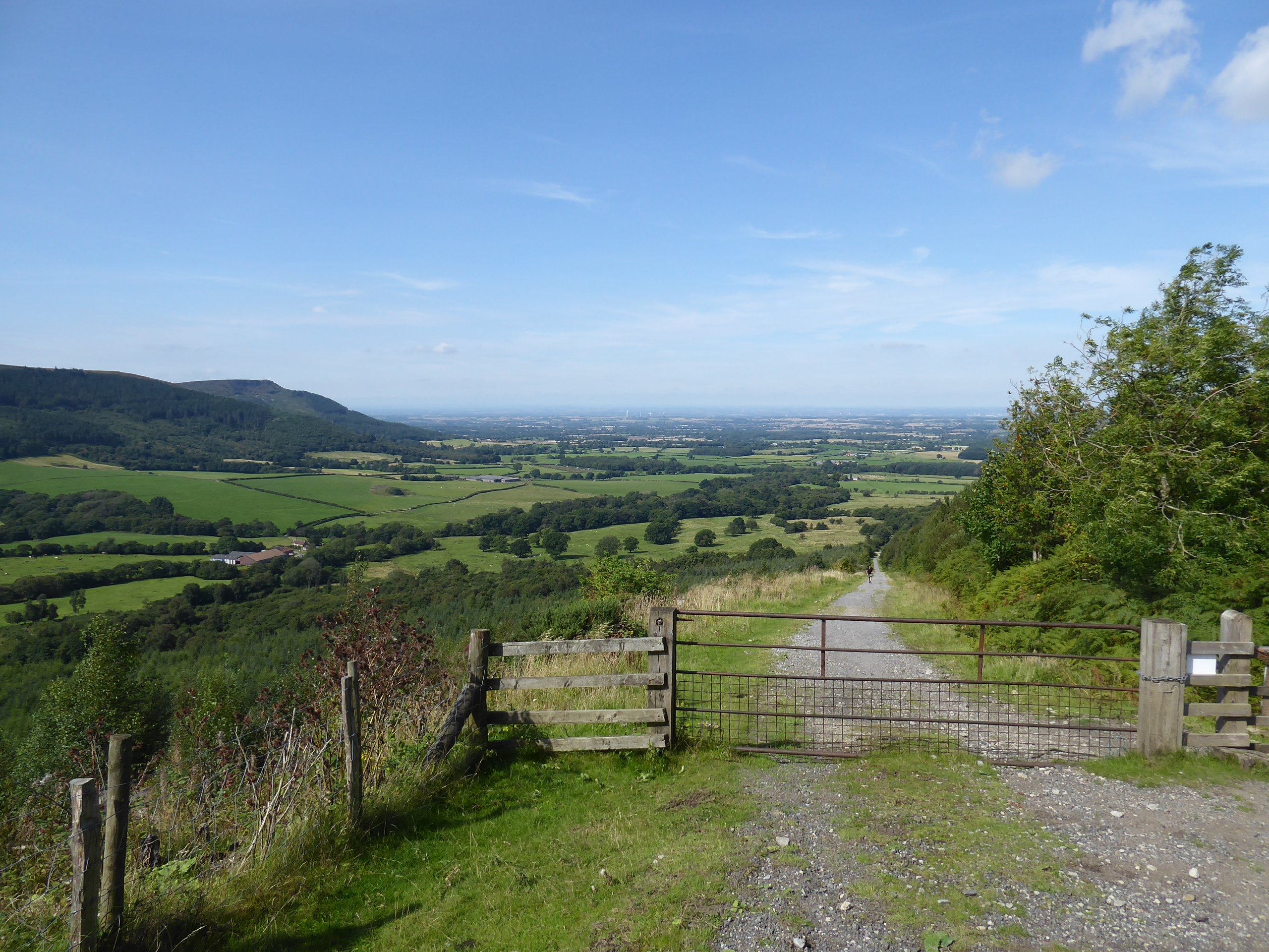
| The Ingleby Greenhow Valley, among the Cleveland Hills. |
Our railway path can begin as we arrive near Bank Foot farm, passing another crossing house and meeting the arrow-straight and level track that aims itself into the valley of Ingleby Beck, with its high sandstone edges rising all around as we pace on in the relative shade provided by the steeply rising bank of Park Plantation to east of us, knowing that it's quite a trek along here before we get to see much of anything by the way pf heavy engineering, but enjoying the flat surface as we know what's to come later on, and pondering why the North York Moors haven't drawn my attention until now, in my twelfth walking year as the faces we can observe from here match any to be witnessed in the Pennines. Something to see is eventually met at Incline Foot, as we meet a quartet of cottages, now owned by the Forestry Commission, which once oversaw the marshalling yard where loads of ironstone to be shipped to the furnaces on Teesside and the empty wagons to be filled with it were shuffled for nearly 70 years, demonstrating the scale of the operation of this standard gauge railway that proves to have been far more than the tramway system that I'd expected of it, and all the engineering, and the walk's effort focus can be found beyond as we come around to the Ingleby Incline itself, rising over 200m in a straight line up the valley side to the moorland level in less than a mile, at gradients that were clearly too steep for hauled trains, and was cable worked for it entire lifetime. Straight up is the only walking option, to test out my lungs and stamina in my post-Covid condition, turning on the power but not generating a lot of speed, with the brain breaking down the ascent into four different sections of varying steepness as we rise above the treeline and let the other pair of walkers on the track rip me off as I keep things steady, passing above the tree line and watching the south-westward vista across to the valley head open out, aiming for the gate that looks like the first mental target and frequently looking back in order to contextually locate ourselves with regards the towns of nearby Teesside, only 15 miles away to the north of us, as the going, heat and stern breeze all take their toll.
 |
| The Crossing House at Bank Foot. |
 |
| The Rosedale Railway sets its course toward the High Moors. |
 |
| The Railway Cottages at Incline Foot. |
 |
| The Ingleby Incline presents 200+m of ascent in less than a mile. |
 |
| Slowly Rising above the Treeline. |
 |
| The view back from the moorland gate, to contextualise Teesside. |
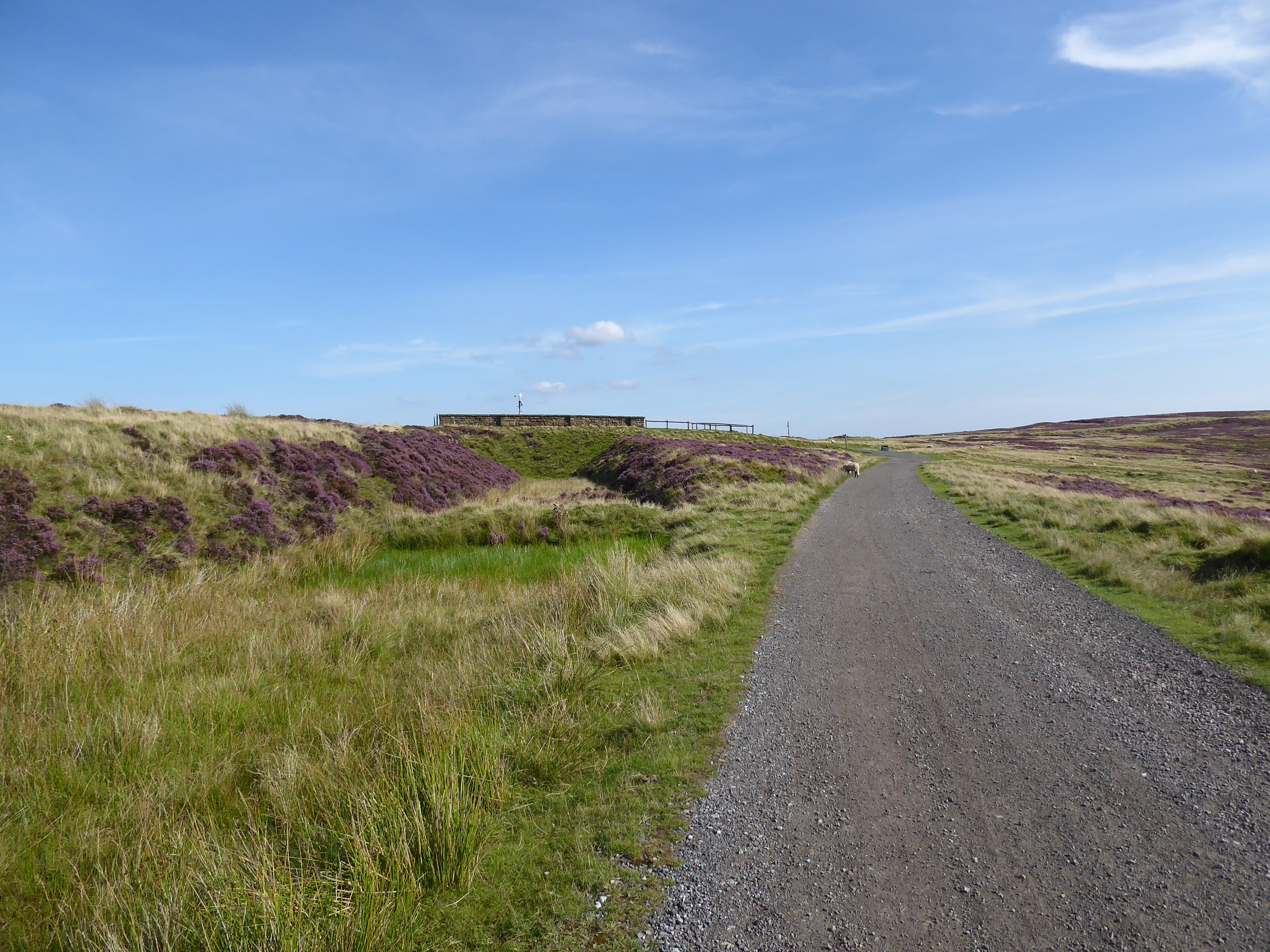
It's even slower going on the top half, as we arrive below and the rough and worked out crags of Greenhow Bank, where Jet was mined out in the distant past, and we also arrive amongst the sea of purpling heather, demonstrating our altitude as we enter rough cuttings that offer some shade from the wind, but not the sun a it shines directly ahead of us, pausing enough to correctly place Middlesborough and Stockton into the Teesside horizon, before we press on up the final section, never quite finding the extra gear to complete the ascent, and finding the surface never all that happy for walking on, rendering me glad that I'm not of an age to have been expected to work in its construction, operation or maintenance, and feeling happy to have started out already 190m up from sea level as the 410m top is met. 35 minutes to do the climb feels like what I was expecting, and we can immediately find somewhere to sit among the ruined buildings at Incline Top, in order to take lunch and water thoroughly, grateful for the fact that a contextual model, in rusted iron naturally explains the operations hereabouts, as we'd not have gathered that without assistance, and the nature of the moorland railway beyond becomes apparent as we set off south-easterly, on a level track again across Greenhow Moor, putting the Tees catchment and the tops of the Cleveland Hills behind us and shifting though shallow cuttings and over the track's 414m summit, to meet our long passage around the high edges of Farndale, tangling with the Cleveland Way route as it comes in from the west, down from Round Hill, the 454m moorland summit. A shallow rise of an embankment takes us up to Bloworth Crossing, a formerly staffed site on the long, and longitudinal, moorland track from Kildale to Gillamoor that the modern world didn't adopt as a road, beyond which the wild moor awaits as we come across a higher embankment across the fall of the Low Bloworth beck, before we start with the tightly curved passages of the contour hugging path around Farndale, having the views evolve with each passage through the shallow cutting, looking far to the southeast, as the valley falls away towards the Derwent valley in the distant south, and pondering whereabouts on the Yorkshire Wolds hills might be landing on our remote horizon, rising above the valley throat, sadly not immediately recognisable as nothing in this locality describes a familiar shape of any kind.
 |
| Ascending through the Heather line at the Moorland edge. |
 |
| The view back, just shy of the Summit. |
 |
| The ruins at Incline Top, and the contextual model. |
 |
| The transitional cutting across the Moorland Crest, into Farndale. |
 |
| Bloworth Crossing, on the only moorland track to be seen up here. |
 |
| Passing through the cutting leading to the contour path above Farndale. |
Settling a railway line in at a consistent altitude of 370m for seven miles and hanging with the contour isn't just a matter of dropping tracks and ballast on the moorland surface, of course, but every inch needs engineering to just stabilise the trackbed, allow for drainage and make viable passage as the landscape rises and falls around the plotted level, and around the heads of Farndale, this is obviously the case, as an embankment lifts us above Wares Gill and a cutting digs us through the rise of Middle Head, scouring a way around the lower edge of the north-south water-shedding ridge on the North York Moors, the one which the Lyke Wake Walk passes over (and No, you'll not catch me approaching that one any time soon), noting the drainage ditches stained red by iron as we pass above the streams falling to form the local river Dove. Another thing to always note on the moors is the birdlife, having already seen plenty in the Esk Valley, as up here we are exclusively in the realm of the Meadow Pippit and the Willow Grouse which flit around and hide among the long grass as we plough on above the edge of Farndale, having some difficulty with doing our mid-day check in with Mum despite having a mast on the visible horizon to the west of us, which might have this moorland feeling very lonely indeed, is it wasn't for the presence of other walkers and riders up here on the moor, enjoying the good weather that has arrived on the last weekend of the Summer holidays, so taking a watering break in the sunshine before the long press resumes. The variation to our views comes as we pass onto the embankment that rises over Esklets, with the moorland falling away to the northeast of us as we pass across the upper headwaters of the river Esk itself, just one of many heads it has but offering another moorland structure to admire as we progress, allowing ourselves a small feeling of being close to our holiday base camp as the only other moorland track to be seen up here passes out of upper Farndale and down towards West Ayton and Castleton, with the long level drag leading us eventually around to the first appreciable climb that we've made since attaining the moorland, as the wide apron above Farndale noticeably narrows and the nab ends beyond Oak Beck Head demand a rise to make another dramatic corner of a radius that seem wholly unsuitable for full sized trains, especially ones hauling heavy freight at altitude.
 |
| Embankment above Wares Gill. |
 |
| Passage round Middle Head. |
 |
| The Downfall towards Farndale, and the River Dove. |
 |
| Grouse Spotting in the Moorland Landscape. |
 |
| Looking over the High Moor apron to Farndale. |
 |
| Looking over Esklets to the Crags above uppermost Eskdale. |
 |
| Reverse Angle to Eskdale, with Moorland Pools. |
 |
| The rise above Oak Beck Head to Blakey High Moor. |
The cutting passage at the top of this rise brings us around to the edge of High Blakey Moor, below a landscape that's apparently littered with pre-intensive industrial coal pits, with Farndale looking opened out below, but still home to little more than scattered farmsteads after all these miles of observation, while the view out of the valley evolves to add the Howardian Hills, obscuring the westward fall of the Derwent valley, as we rise around the final cutting and sharp turn of the day to finally place a building onto our local horizon in the east, namely the Lion inn atop Blakey Ridge, meaning that we're coming around to the end of the day and that those distant glimpses of cars we saw reflecting the sunlight many miles backwere indeed in today's future. We've one last embankment and beck traversal to complete as we come down above Gill Wath, falling away down towards the properly rural inhabited lower half of Farndale, with the hamlet of Church Houses barely discernible at the valley floor, as we come around below the fall from the ridge top, where numerous ancient tumuli still litter the hilltops, taking us above a ring of craggy edges on the moorland apron and giving a direct sightline out of the valley to Drax Power Station, the only object below the Vale of York to be visible at this remove, with the grouse still hiding among the moorland grass and one large raptor, that's not a Kestrel or Buzzard, floating around on the rising warm air. Past the shortcut turn to the pub up the hill, it's an uphill press towards the day's end at Blakey Junction, which has been visible for as long as the tavern on the hill, though not quite so prominent as a weather station and the rise of the road out of Farndale, with our friendly bridleway track leading us up alongside ditches filled with contained moorland water and past the now obscured branch of the line towards Blakey Pit, where much of the coal necessary for the ironworks was mined locally and not imported before we come up by the unfilled bridge on the Blakey Ridge Road, beyond which the branches to the mines and kilns in neighbouring Rosedale split off, just beyond the roadside car parks
 |
| Lower Farndale reveals a distant southern horizon. from High Blakey Moor. |
 |
| Last Cutting of the Day, and the Lion Inn's reveal. |
 |
| Last Embankment of the Day, above Gill Wath. |
 |
| The Fall of Gill Wath, into Lower Farndale. |
 |
| The Final Climb of the Day, onto Blakey Ridge, |
 |
| If you know Raptors, this needs Identifying |
 |
| Blakey Junction, left under the Ridge Road, right to Blakey Pits. |
That's all for the second leg of this trek, though, as our day's break lands here, at 4pm, which feel like excellent progress in hot and exposed conditions that have been unlike all my West Yorkshire trips, and it's also pleasing to know that my Parental Taxi has also gotten here without difficulty, with Mum having negotiated her way here via the Guisborough Road, Danby and Castleton and demonstrated her mettle as a moorland driver at the first attempt, which is just as well as we're going the be back up here in three days time and she's going to get a lot more experience of driving this long circuit as my Moorland exploits bring me back to tour as much of the Rosedale iron-workings as can be fitted into a single day.
5,000 Miles Cumulative Total: 6126.7 miles
2023 Total: 204.5 miles
Up Country Total: 5,634.9 miles
Solo Total: 5784.1 miles
5,000 in my 40s Total: 4726.6 miles


No comments:
Post a Comment