15.1 miles, via Scar Head, Wood Nock, Triangle, Mill Bank, Lumb, Cotton Stones,
Lighthazles, Blackshaw Clough, Syke Hill, Soyland Moor, Manshead End, Collin Hill,
Cold Laughton Drain, Byron Edge Drain, Whiteholme Reservoir, White Holme Drain,
Turley Holes & Higher House Moor, Withins Moor, Warland Drain, Langfield Common,
Gaddings Dam, Basin Stone, Rake End, Salter Rake Gate, and Birks Clough.
Our morning ride out for today's excursion, breaking the theme of the revive season by staying wholly in the Calder catchment, show us the we can have no clear expectations of what the weather is going to bring, as we board our early train from Morley in bright late Summer sunshine, which gets replaced by a fierce rainstorm as we pass through Brighouse, which has passed as we land in Sowerby Bridge, under skies so dark and overcast that all the street lights have come on, making 8.05am feel a lot earlier than it is in reality, and gets you wondering what the day might bring before any footfalls are made. We have the 69th and final unseen railway station in West Yorkshire as our destination, with a lot of Calderdale to cross to get there, so haste needs to be made, away from this one and it curious mix of vintages, hitting the rise of Norland Road as swiftly as possible and getting the pulse going as we head up the double-arrowed lane, before rising with the footpath alternative to Boggart Lane as it heads up to Sowerby Croft Lane, immediately regretting the choice as the steep setts and steps are as slick as after the recently passed downpour, but at least the views reward as we ascend to the high east side of the Ryburn valley. We'll hang on this edge as we go on for the initail stages, passing through the elevated hamlet of Scar Head before joining the high track of Long Lane, a road that really looks like it ought to go somewhere but is only used for remote farm access as it settles in among the angled fields, not too far away from the Rishworth branch line, which hides under the tree cover below as we pass the path tops that we had intended to use to access it, coming around to the high reveal of the valley ahead, looking up to the field we walked above a few weekends back, and down to Bank House farm, somehow crammed into the angled fields below. Rise as the lane chooses to crest high, before our gradual descent starts, beginning as we drop down to the junction at Lane Bottom, where all of the ongoing routes are not recommended to motorists, take the lower road, which takes us past the pair of Wood Nock farmsteads, again clinging to the valley side, looking like desirable country retreats these days, with the road ceasing to be driveable beyond, and pretty much unwalkable too as the steep run of uphill cobbles looks unappealing and slick, but an alternative is presented that features no ascent at all. So footpath it instead, guided through to the top edge of Dodge Royd wood, through which the railway cutting gouges, following the contour around as it passes through the open fields and meets the descending track from Oaken Royd farm, a wise corner to cut off as we are quickly led to the bridge over the throat of Triangle station, and a route is retraced as Stansfield Mill Lane drops us down past the cricket club and over the Ryburn, past the eponymous mill and up to meet the A58.
 |
| Sowerby Bridge station in the morning gloom. |
 |
| The path of setts up to Sowerby Croft Lane. |
 |
| The wandering and seemingly aimless Long Lane. |
 |
| Upper Wood Nock. |
 |
| Footpath and former Railway converge above Triangle. |
Turn onto Rochdale Road, among the surprisingly old faces of Triangle village, and wander with it as far as the Triangle inn, which looks like it hasn't seen any business in a while, despite having the village war memorial on its wall, and resume our trajectory towards the moorland out of the valley up Oak Hill, watching the rain breeze across the valley as we enjoy being shaded from it, rising high to Oak Lane and getting an upstream view that shows the mass of woodland that fills the Ryburn valley, as we pass below the Deer Play farms and head up above the Lumb Clough side valley. It's not all that far along that we meet Mill Bank, stretched out along the high lanes that pass up here, heading on past the wonderfully named Slaughter House and the vicarage for the church that is nowhere near here, ahead of taking the upper Mill Bank Road, above the long terrace on the Lower lane, and below the old chapel and Sunday school, crossing another of this seasons route to pass between the village school and the precariously perched cottages, ahead of finding that even a tiny and wholly rural flavoured village like this can also have a close of council flats attached to it. Fields await beyond as we trace the side of the clough as we rise, passing the site of Lumb mill as we rise up to the hamlet of Lumb itself, where farmstead and another mill site clustered around the stream, where the road splits off to head up to St Mary's church, at a remove from our route and looking proud and spired, altogether too large for the sparsely populated upland of its parish, with us rising below another shower of drizzle towards the Alma inn at Cotton Stones, which has either set up its vast beer garden for effective socially distanced drinking, or is anticipating a wedding reception with a view soonish. The light rain persists as we head up Clay Pits Lane, between its eponymous farms, with our easterly horizon towards Norland Moor still looking grey as we land on Lighthazles Road, which carries us on among this landscape that you just do not acknowledge from any of the valley roads below, passing over the Calderdale Way route as we come up to Clay House, probably the oldest and proudest farm on this hillside, ahead of approaching Lighthazles hamlet itself with the western horizon looking clearer, which bodes well. The ridge of Manshead Hill is thus hinted above as we land above the depression of Blackshaw Clough the uppermost headwaters of this side valley of the Ryburn, with the road diving down through it below the plots of Clough farm, and I'm pretty certain that we are in the landscape where one of my old school friends does her equestrian thing, an odd little factlet to consider as we rise up the far side of the clough and pick our ongoing trajectory, up Cross Wells Road and Causeway Head Lane at Syke Hill.
 |
| The Triangle Inn, Triangle. |
 |
| 'Upper' Mill Bank. |
 |
| The Alma Inn, Lumb or Cotton Stones? |
 |
| Clay House, Lighthazles. |
 |
| Blackshaw Clough. |
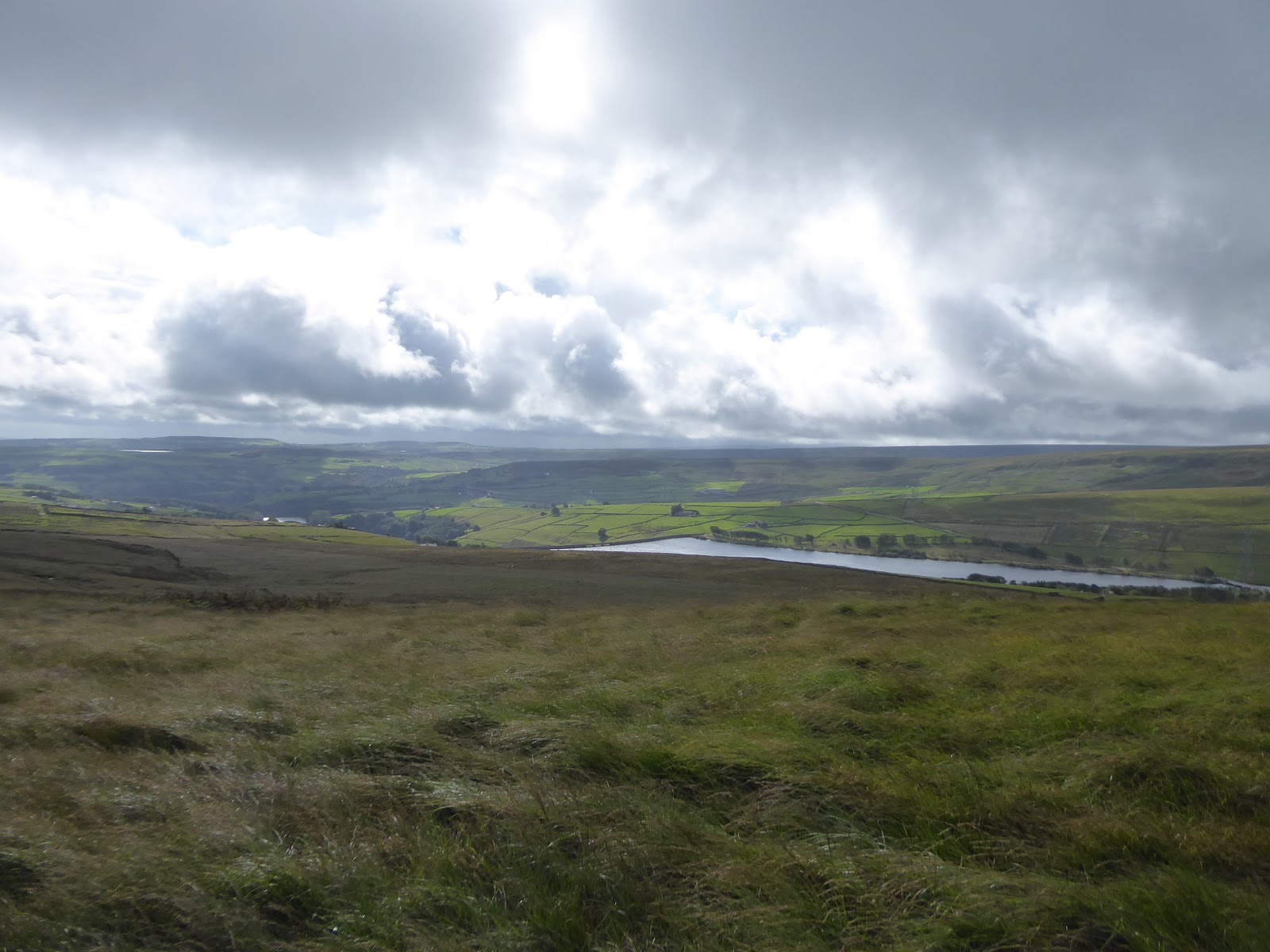
This lands us on Blue Ball Road, a name that doesn't stop being funny no matter now many times I've encountered it, following it as it continues to rise to the southwest, with only two more farmstead on this laneside, both weather protected by banks of trees, before we enter the rougher fields below the moorland, with great views abounding, with the ribbon of farms reaching up the rise of Farrar Heights to the south of us, and the run back to the downstream Ryburn behind us as we head up towards the route to the moors that we were compelled to abandon a month ago. Land on Flight House Lane and get the views that that rain denied us in July, giving us a sharp horizon all around as our route to Manshead is revealed, as well as looking over towards Blackwood Common and Rishworth Moor as the angle of the Ryburn valley is crossed, and the feeling of being able to do at least some of our moorland trip in decent weather is enhanced as we come up to Coal Gate Road and join the vast upland of Soyland Moor with sunshine breaking through the clouds, joining the Yorkshire Water permissive path as it leads us up past the sheep grazing among the long grass and heather, ahead of the plantation of conifers. It's a decently wide track to follow up past this small woodland, following the wall that bounds that farmable fields, where dun cows graze, and we plough on to the moorland heights, getting a reveal down the ridge to its northern end at Crow Hill, and taking the turn at the wall corner as the path diminishes slightly and directs us up towards Manshead End, and so moorland walking starts in earnest, having the track completely to myself as we look to manage 100m of moorland climb over the next mile or so. There are posts to guide our way as the western horizon beyond the grass and heather offers little to look at beyond the southern end of Manshead, and the paths ahead offer a choice of surfaces, being clearer but soft, or firmer but uneven, both not too fum to walk on after the rain, but the lower one offers the more appeal as it hangs closer to the wall at the top of Baitings Pasture, giving us the better views down to the A58 and the Pylons as they crest over into Lancashire, down to the reservoirs in the Upper Ryburn and over the the Rishworth moor ridge to the south, one which is so indistinct in the mind, that I think that its tops of Dog Hill, Cat Stones and Flint Hill have never been name checked here. The rise of the path turns out to direct us all the way up to Manshead End, as it's not obvious where its going on a 2D Google maps plot and its absent entirely from my ancient OL21, but getting to 400+m up isn't going to cause me a fuss as we approach the bench and guide cairn at the southern end of this moorland, especially as we can look west to see that the only clouds that are in the air are barely grazing Blackstone Edge and that there's no immediate risk of rain to come from over the Pennines in the direction of Rochdale or Rossendale as we break for elevenses.
 |
| Blue Ball Road, looking upstream in the Ryburn. |
 |
| Landing on Soyland Moor in altogether more pleasing climes. |
 |
| The Permissive Path to Manshead End. |
 |
| The Upper Ryburn Valley, with reservoirs. |
 |
| Manshead End, which I hadn't actually anticipated visiting. |
Having gotten this far up, we need to make the short detour northwards that traces our 2013 route up to the 417m trig pillar, which is still one of the more disappointing summits, as its location at the level top restricts the views though 270 degrees while being bounded to the south by the higher Rishworth - Blackstone Edge moorland, but it's only a quarter mile out of the way and does show up our route to come to the west, not taking the easiest route to the uppermost Calder by any means as we gain the permissive route that pushes us off the ridge and down to Collin Hill, on an undulating route. You can be glad that Yorkshire Water has been kind enough to mark out the paths over their aquifer up here, as route finding could have gotten trick without the guide posts that direct us down to the lea where a ruined shooting hut, the only feature of note on this moor, sits ahead of the soggy depression that needs duck boards to traverse it, from where we need to rise again on the gently ascending moor to seek the moorland drain that rolls around Hassock Hill, again only a short climb but enough to remind me that I'm still an amateur when it comes to facing the real risks of open moorland traversal. Thankfully, the ditch of the Cold Laughton Drain is easy enough to locate, snaking its way to the west to feed the distant reservoir that once fed the Rochdale Canal, with a path following it on a contour that we'll be keeping to for a good stretch of today's upland excursion, which the eye can start to trace as we look over the heather and grass that coats the top of Turvin Clough, the uppermost reach of Cragg Vale, and on to the next upland of Turley Holes & Higher House moor, as we also meet other walkers out on the moor, at the edge of where a brief stroll out from Calderdale is plausible. It's a longer walk to meet the rising Turvin Road than expected, mostly because they meet at a pretty acute angle, and it's an odd feeling to make my first official footfalls up here after nine seasons of walking as the B6138 has been our red route between Mytholmroyd and Manchester for many trips and as My Good Friends in the valley below have brought me up here a couple of times for healthy new year strolls, tracing the reservoir access tracks as we walked off, and made space for more, seasonal excess. Onto the the Byrons Edge Drain track we thus head, with a more clearly defined channel tracing its way around the eponymous last hill on this corner of West Yorkshire, with the pylons running over its top, and the headwaters of Turvin Clough running below it, as the excess water is collected to feed the reservoirs, while we keep an alert look to what the weather might be doing as the cloud cover briskly shifts overhead, threatening to improve or worsen with each passing minute as we pace the hard track onwards.
 |
| The route off Manshead End to Collin Hill |
 |
| The ruined Shooting Hut at the path lea. |
 |
| Cold Laughton Drain. |
 |
| Turvin Road and Clough, the uppermost reach of Cragg Vale. |
 |
| Byrons Edge Drain |
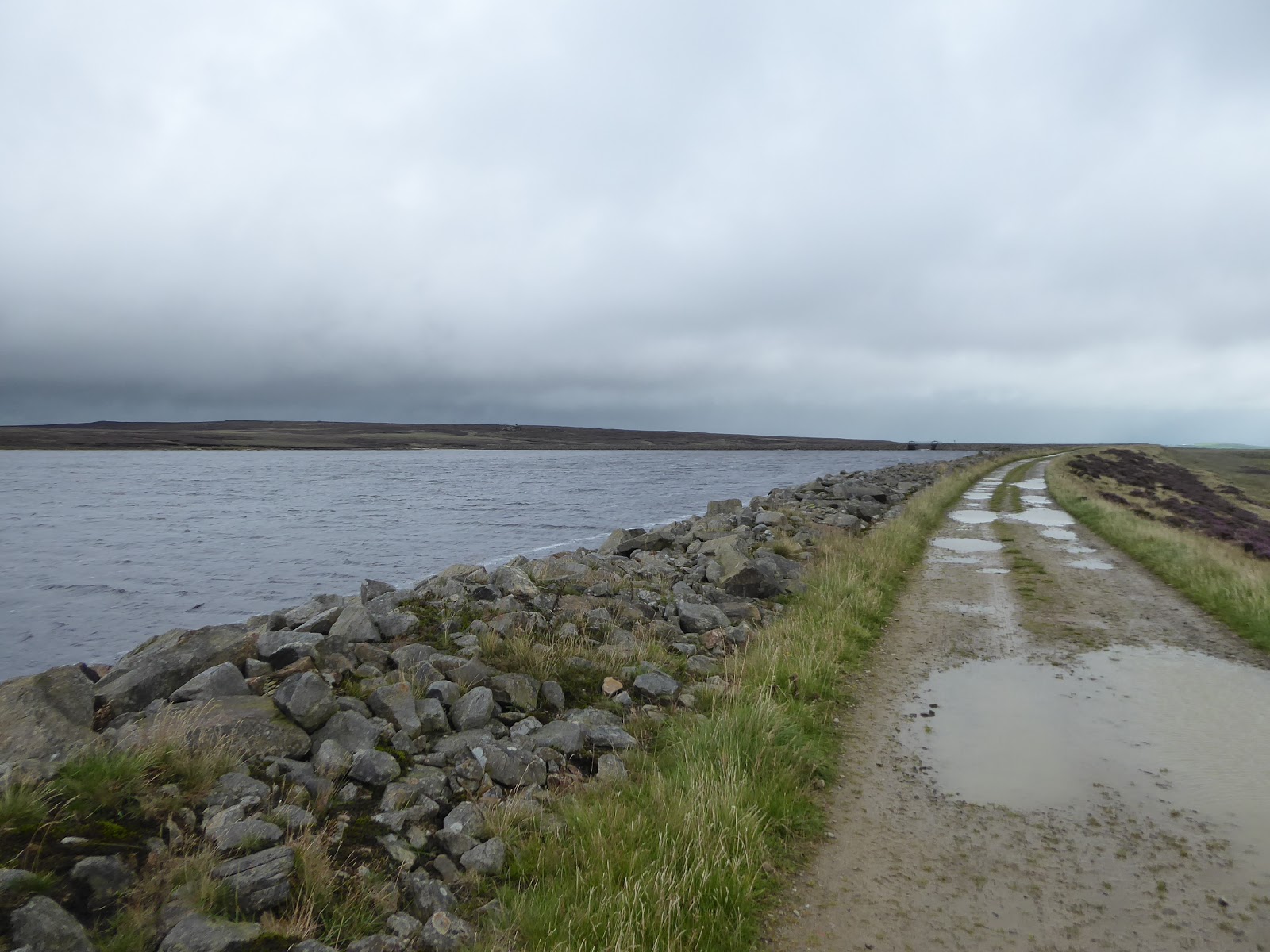
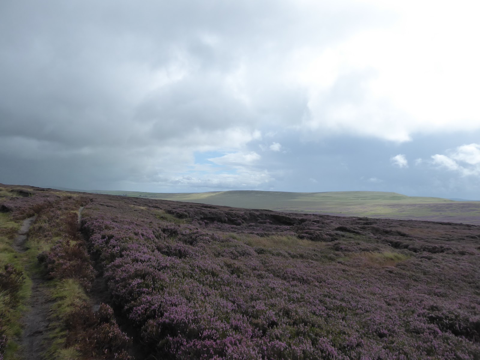
Coming around past the sections of the drain shored up with scaffolding, and the sluices that terminate its downhill flow, we pass half way on the trip, despite being still a while ahead of midday, and come up onto the bottom corner of Whiteholme reservoir, with our route starting on its extra miles of indirect wandering as we furn onto its long embankment dam, where we can study the oncoming weather fronts as they blow in from over Lancashire and note that we will be doing a tour around the Manshead Hill upland as it settles on our eastern horizon. Greet the last walkers to be seen up here as both sunshine and showers blow overhead, as we meet the sluices and run off channel that sends excess water into Cragg Vale in times of heavy rain, angling around the northern edge of the reservoir to join the inlet channel that will run us around the top of the White Holme Moss moorland, on which the Woolpack Stones feature as one of the rare gritstone outcrops on Calderdale's moors, on a mass that actually rises higher than Great Manshead off the the east, but lack the well defined profile that we can take in from here. The access track runs as far as the sluices that feed this southwards flowing aqueduct, with the White Holme Drain taking on a much rougher channel beyond, accompanied by an equally rough track, carrying us kinda northbound through the sea of heather, while gradually revealing the descent of Cragg Vale ahead of us, splitting the almost complete horizon of moorland that has surrounded us, and the 380m contour altitude gives us some shelter from the wind that blows in from the southwest. Sunshine keeps coming through to encourage us on, burrowing on into the mass of Turley Holes & Higher Houses more, where there's nothing on the ground to indicate the origin of either of the names as we come across another low outcropping of gritstone that was plainly inaccessible from the valleys below when rock as being extracted for building the settlements far below, and it's only the drain passage that makes this route viable at all, as we carry on, gaining Midgeley, Warley and Ovenden Moors on the distant northern horizon. The rain seems to be slaying Halifax as we carry on along the drain, which has gradually decreased to a grassy groove in its uppermost stretch, but we've no way to get a grasp of the oncoming weather as the moor rise obscures the view to the southwest, but the luck seems to run out as we get Sunderland Pasture plantation and Stoodley Pike rising on the nearby northwestern horizon, ahead of the turn west above Withens Clough, as the rain sweeps in, obscuring the view of the main side valley of Cragg Vale, with us well past the only available bailing point, as trying to get off the moor via the Two Lads cairns below us would be harder than keeping to the route as plotted.
 |
| Whiteholme Reservoir and Dam. |
 |
| Woolpack Stones and the White Holme Drain inlet. |
 |
| The Great Manshead ridge, beyond Turvin Clough. |
 |
| Rock outcrops on Turley Holes & Higher Houses moor. |
 |
| The diminishing White Holme Drain, and the passing of the pleasant weather. |
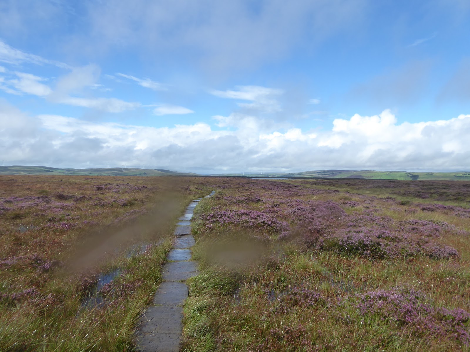
So we turn west, with the wind blowing the rain right across our path, keeping to the drain passage as it gradually peters out, passing the split boulder by the pathside known as the Cloven Stone, with the ground rapidly dampening as we come up to conveniently find another old shooting shelter which can at least offer us shelter from the wind within its wall, if not the worst of the downpour as it blows over, thanks to its lack of roof, as we take lunch and steel ourselves for the push to the finish line, probably not more than a couple of hours distant, observing the views from door and window to see if the rain is abating. It doesn't matter much either way, as we need to move on regardless, and we are hitting the hardest part of the route as we land between the pair of drains on the moorland as we press west, over muddy and uneven going that just does not invite trying to go at the hurry-up as the streams that run down into Withens Clough have to be traversed, and the intensity of the rain worsens, to keep the reservoir below almost completely hidden from view while the track ahead gets so damp that the boots and trews are waterlogged within minutes, and on rush of precipitation is kept off by my waterproofs. The way to the head of Warland Drain is provided by pipework that feeds it over the undulating moor surface, which keep the mind focused in the right sort of direction as we go, sometimes finding it easier to walk atop it rather wading than through the ankle deep water that sits on the path across this damp aquifer, and the intensity of the rain across Withens Moor gets so bad that I even put my camera away, as the last rainfall of similar vigour experienced in upper Wharfedale managed to completely cook it, and I've no desire to have to retrace this route in the future solely for the purposes of documenting it. So it's head down and press on as the weather sweeps over, keeping on the westwards push on a route that is thankfully never in doubt as the drain and contour aim us on towards the Pennine Way path, and the ridge between the Cragg and the Calder, carrying on below the Holder Stones on the Moorland above as we aim at the fingerpost on the path junction ahead, with the rain easing off just enough to take pictures again as we approach our high moors route from 2013, at the western boundary of our experience field. As the rain still falls steadily I can still feel like a rare sort of explorer as the flagged route of the Pennine Way to the southwest is all mine for today, as all the wise souls have kept away from this route in this weather, but there's reason to feel hopeful as the upper Calder valley creases the horizon to the west, as there's a distinct break in the clouds visible, the first one seen in more than an hour, which suggests we might not receive a continuous saturation all the way down to the finish line.
 |
| The shooting hut above Withens Clough. |
 |
| Stoodley Pike and Sunderland Pasture plantation, above Withens Clough. |
 |
| The Warland Drain pipework on Withens Moor. |
 |
| The rain easing off a bit as we approach the Pennine Way |
 |
| The Pennine Way traces Warland Drain, and approaches a break in the clouds. |
We need to orientate ourselves as we meet the sluices and run-off channel at the path corner above Warland Reservoir, as this is our long way down, wandering a way down into the uppermost reaches of Calderdale along a new boundary path, hitting another flagged path that drops downhill very slightly across the waterlogged terrain of Langfield Common, aiming us the moorland cistern of Gaddings Dam ahead, but the slow going of the route is offset by the rain stopping and the sunshine bursting through, which lifts the spirits as we press towards the cliff tops above Todmorden. It also allows the gear and camera to dry off as we go, so as we push down to the damside we can get an horizon to admire from the wind farms on the high eastern flanks of Rossendale around to an apparent waterfront view over to Stoodley Pike, able to to be photographed at will despite my Lumix wanting to engage its telephoto lens every time it is switched on, ahead of the reveal across the valley to the ascent of the A681 up Midgelden Clough, which leads the eye all the way to Pendle Hill on the far horizon. More locally, we descend from the dam, finally quitting the high altitude that we have been at for most of the last four hours, and aiming ourselves downhill into the main branch of the Upper Calder, keeping the pace going as the weather still isn't promising to play nice on the last hour or so, and it feels like we are racing the next downpour as we hurry down to the rock outcrop that sits above the valley, namely the Basin Stone that looks like the NHL's Stanley Cup or a baby's high chair from certain angles, one of the few surviving wind-carved hunks of gritstone in the valley that isn't on Bridestones Moor. There's choice of paths here, one of which could send us directly downhill, but I'll stick with the clearer and signposted route to the northwest as slithering down into the valley of Walsden Brook without having a clue about the terrain I'm trying to traverse does not seem too wise as more rain falls, and so we drop downhill towards Rake Head where paths converge above the junction of the Calder, either directing you towards Todmorden or back towards Walsden, the most hidden of villages in the high valley, where we intend to head. We are also upon the Pennine Bridleway as we head down the long run of steep setts to the south, getting us off the high moors and reminding us of the plan that we'd had, back before the pandemic, to walk the Mary Townley Loop in my late Summer Jollies, an absolute pipe dream to reflect on now as Walsden is revealed below, with the canal pound obvious from our 2012 traversal, as well as the cricket club, where we once crashed the beer festival, many more moons ago.
 |
| The sunshine returns for the passage of Langfield Common. |
 |
| Stoodley Pike above the Gaddings Dam shoreline. |
 |
| Basin Stone, ahead of the next wave of rain. |
 |
| Rake Head and the Pennine Bridleway towards the Calder. |
 |
| The view to Walsden from Salter Rake Gate. |
This is a corner of the county that clearly has no interest in offering any direct route off the moors, and Salter Rake Gate has a good old undulate and meander as it comes in above the runoff channels of Birks Clough, flowing off the rugged and sloped grasslands and charging away noisily as the last rainfall of the day passes overhead, ahead of the sunshine resuming and us landing back on a road surface by North Hollingworth farm, and the cluster of suburbia that has grown around it, high above the valley. Hollingworth Lane doesn't offer the friendliest of driveways though, steeply dropping downhill with barely enough space to accommodate a single vehicle as head down below the roughly rocky outcrop surmounted by a microwave mast, before it drops into the woodlands around the still noisy Birks Clough, where the direct route downhill looks treacherous and the ongoing path from the hairpin of the lane, through some suburban gardens to Henshaw Road cannot be easily located, and thus we continue down to the valley bottom past the village vicarage and Birks Mill, disused and derelict. This lands us below St Peter's church and its old school, and as we cross over the Rochdale Canal via Birks hall bridge, by Lock 28, we seal ourselves a new boundary to the field of walking experience as we touch our 2012 towpath route, before almost dropping out onto the A6033 Rochdale Road at the bottom of the terrace on St Peter's Gate, eschewing the main road walk by heading up Hollins Road to pass the still in use Hollins Mill and over the canal again via Hollins Bridge, with a fine view back to the parish church ahead of meeting the split level Terrance and local flatiron simulacrum at the corner of Alma Street. We join this, as it takes us past its tall terraces and the redeveloping mill site and on to Alma Road, our second such location named after the Crimean War battle of 1854 on today's trail, getting the view up to more multi-storey terraces that is my definitive memory of last being here eight years ago, and we then thread the new boundary thoroughly with a third passage over the canal, ahead of passing over the noisy upstream flow of Walsden Water, bottoming out the valley ahead of landing on the A6033 again, just across from Walsden station. Over the footbridge we have to go to land on the inbound platform, concluding the trip at 2.35pm, well ahead of my ride home, but with enough time to finish lunch and wring out my socks, whilst simultaneously celebrating my arrival at the 69th and final railway station in West Yorkshire to be seen on my walking travels, an odyssey that shouldn't have taken me nine seasons to complete, but one that has caused me endless amusement since it dropped onto my planning radar, and one that ought not to be considered complete by any means, as there's still a lot more stations to find further afield, in Lancashire and South Yorkshire, just for starters.
 |
| Birks Clough, above Walsden. |
 |
| Descending Hollingworth Lane to Walsden. |
 |
| St Peter's church and the Old School, Walsden. |
 |
| Walsden's High Terraces from Alma Road. |
 |
| Walsden Station, 69th and final to be visited in West Yorkshire. |
5,000 Miles Cumulative Total: 4578.5 miles
2020 Total: 312 miles
Up Country Total: 4115.5 miles
Solo Total: 4251.9 miles
5,000 in my 40s Total: 3172.3 miles
Next Up: Five Day August Bank Holiday Weekend, featuring, uh, Colne to Calder, again?


No comments:
Post a Comment