19.8 miles, via Fartown, Norman Park, Cowcliffe Side, Reap Hirst, Burn, Stone, Ainley Top, Blackley, Hullen Edge, West Vale, Greetland, Greetland Moor, Norland, Longley, Triangle,
Field House, Hubberton Green, Long Edge Moor, Cragg Bottom, Lumb Stone, Knowl Hill,
Blaith Royd, Sunderland Pasture, Stoodley Pike, Harvelin Park, Mankinholes, Lumbutts,
Causeway Wood, Oldroyd, Kilnhurst, and Stansfield Bridge.
The end of July may have seen Kirklees and Calderdale districts put back into a local lockdown after spikes in Covid infections, but the restrictions seem to apply to private gatherings only, still allowing for free movement and travel, which means I won't be deterred from heading out onto a frankly bonkers distance to be attempting, and the fact that my headline says what it does immediately tells you that walking fortitude came my way despite the distance and the terrain, so let's get right into it here, as this is gonna be a long one. So to Huddersfield in the sunshine we ride, as early as is possible to depart the station at a whisker ahead of 8.10am, aiming ourselves onto the trajectory that opened this 2020 walking season as we head from the square past the George hotel, onto John William Street and past the old Empire cinema before passing under the end of the railway viaduct and on to meet the crossing of the inner ring road, picking the Unna Way side and finding that I've chosen the spot that doesn't have a crossing. Around the commercial estate on the old Newtown goods site we pass, to tangle up with the A641 again, because Bradford Road offers us the way through to the bottom of Halifax Old Road, which splits off to the northwest by the Slubbers Arms, a pub name that I'd hope was unique, as it then leads us on among the residences and terraces of Fartown, taking us over the old MR lines and greenway, and on past the Grimescar club and the mosque in an old chapel before we are soon upon Birkby Hall Road, the route of urban circular route from last year. The housing quality to the east of the lane improves as we rise on, above the edge of Norman Park, which is quiet at this hour and has a war memorial separate from the main one in the town, beyond which we start to find ourselves among the elevating wrinkles that rise over suburban Huddersfield, with the terraces of Cowcliffe side piling up above the road, with the cleft of the Grimescar beck valley cleaving its way through the spread below us, where suburban arrivals cling to the steep side of the lane to ensure feature views from their rears. The single depth of terraces fills the roadside right up to the woods above the town, and the suspicion that the old road has been much more under-used than usual with surpassed route is revealed as we come upon the bottom of Grimescar woods, with the road closed off for ongoing and extensive repairs beyond, and while my instinct says to carry on, the sound of tree surgery uphill suggest that such a move wouldn't be wise and our route will need a revision, heading down the drop of Slant Gate to reacquaint ourselves with the Kirklees Way.
 |
| Empire House, John William Street, Huddersfield. |
 |
| The Slubbers Arms, on the Halifax Old Road corner. |
 |
| Norman Park, at the foot of the Grimescar valley. |
 |
| As deep as we'll be venturing into Grimescar Woods today. |
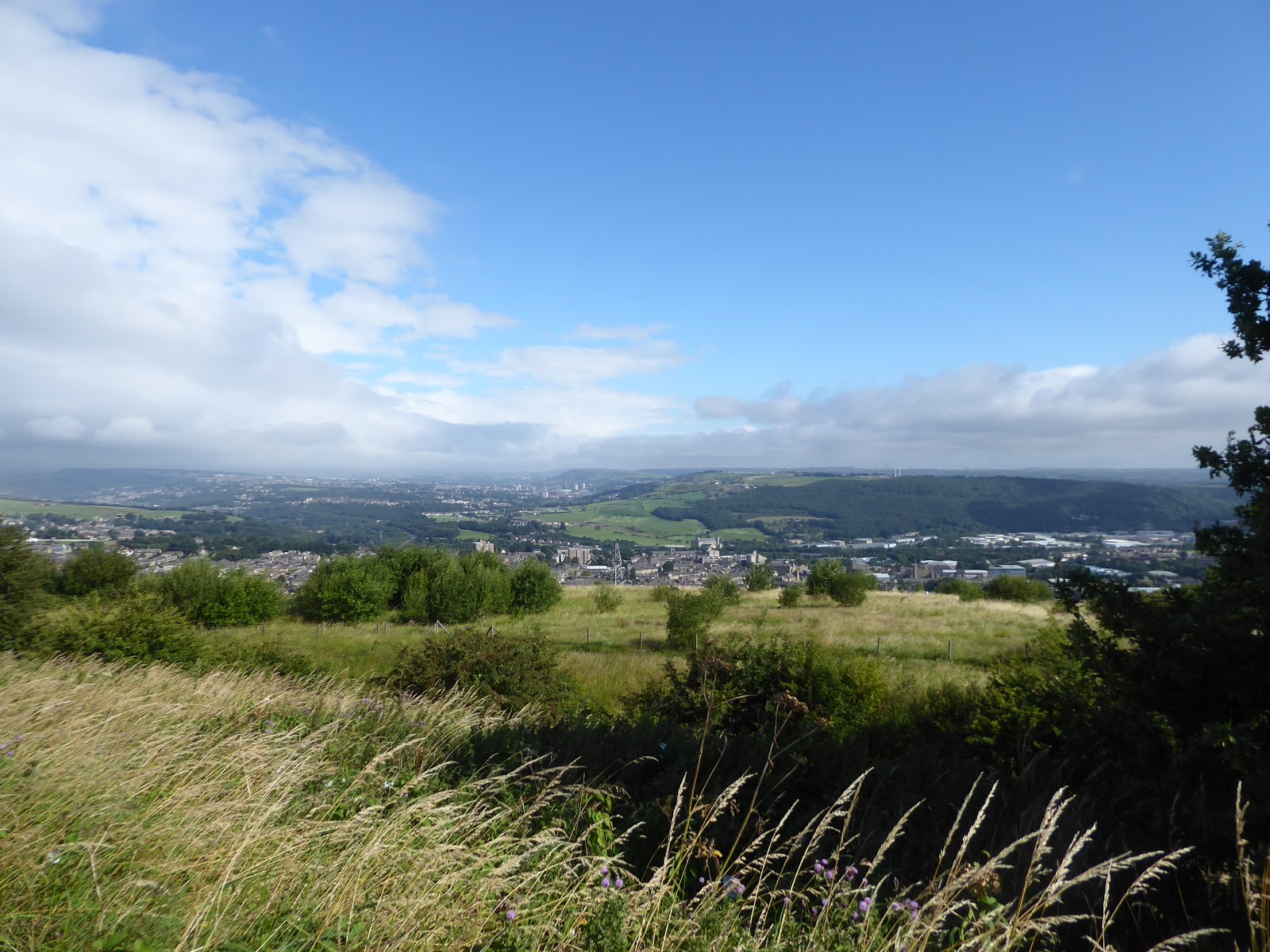
So retracing a path last seen six years ago, almost to the day, will be our alternative as it takes us down the shaded route to the side of Grimescar beck, and onto the farm track that leads to the enduring cluster of farmsteads at Reap Hirst, still enduring at the valley floor with the bank of Grimescar Woods rising off the north and east of us, up the valley side, and we'll press on with the rising track as it takes its turns, guiding us around the suburban growth that has spread down from Birkby Road, while still leaving the bulk of the valley rural and undisturbed. My takeaway from our previous passage along here was of objections having been raised about the potential further residential development of this area, and it seems that they haven't been entirely successful in preventing it, as we meet two burgeoning suburban estates that are coming down from Birchencliffe as we reach the lane top, filling in the fields to the south and west of the farm hamlet of Burn, where we split off to the rising Burn Road as it ascends sharply away to the north, through the hamlet of Stone and back up to the road we were forced to abandon, a mile or so ago. Landing back on Grimescar Road, we get quite the view down the valley that splits northern Huddersfield in two and it's then uphill, past the meadow mowing that make the air offensive to sensitive eyes, to meet the A643 as it comes around Ainley Top, and we'll pick our route to take us along the suburban face of Branch Road, around the back of the Toby Jug carvery, and then over the top of the A629's northward descent and past the front of the Cedar Court hotel complex before we meet the footpath that leads us down to the side of the dual carriageway link that leads to the M62's junction 24. We pass under the motorway and around the traffic island to get a variant on the elevated view over Elland and Halifax that's one of the best from the local highways, a grand aspect to absorb, despite the heavier clouds coming in over the Calderdale hills to the west (showing that this district just can't help itself when it comes to climatic conditions), and with one valley ascended out of we start on down into the next one, gently to begin with along Blackley Road, into the hamlet that shares its name, at the top of the lost lane coming directly uphill from Elland. It seems to have acquired a stray and isolated suburban development beyond its cluster of farmsteads on the hillside, like a plot for the town below got lost or the difference in altitude wasn't considered during its planning, but it does have views to compensate, as we can also look west to see how high we are above Holywell Green and Stainland, themselves settled below the Colne - Blackburne watershed, with the Baptist chapel on the hill crest at the village's end, seeming to be massively out-sized for the settlement that it served.
 |
| Grimescar Wood from Reap Hirst. |
 |
| Suburban creep in the Grimescar Valley. |
 |
| Looking back down the Grimescar Valley, from the Old Road. |
 |
| The superlative view to Elland and Halifax from Ainley Top. |
 |
| Blackley Baptist Chapel, Blacley End. |
The lane descends past the old school house and the fields with the old railway vans in them, offering a footpath that avoids the hairpin of the road, which we don't take as I can't get its gate to open, and thus the road walk down is cramped and frightening as we traverse the apex, regaining safety as the footway resumes and we meet the outermost western edge of Elland, a town we can now consider 'done' as it leads us to the passage over last week's route and onto Hammerstones Lane, which traces the boundary of the parkland of Hullen Edge house, which still sits somewhere beyond its lodge house. Downhill is the continuing path as we head down Hullenedge Lane, leading us off Elland's high bluff and down into West Vale, with the viaduct soon becoming apparent as we look through the tree cover, though our route down to the urban foot of the Blackburne valley isn't straightforward as we need to switch back a couple of times, sharply down Featherbed Lane below the houses with lofty views, angling along Featherbed Close and thence onto Green Lane, with its chapel, old school and multiple views down its many branching terraces as we head down to Saddleworth Road and another familiar route of not-so old. Across the A6114, and down through the old and haphazard industrial buildings we head to meet the A6112 Stainland Road, which we cross in the shadow of the towering Victoria Mills, still dressed in their best vintage colours, to quickly join the B6113 Rochdale Road, which visibly leads us over Black Brook, ending the first descent of the day, and after our pile up of B-roads here, we'll stick with this one as it leads us uphill again, past Clay House and the old Stainland branch line route as we press on into Greetland. Despite having come this way three times over the years, this isn't a village that I could say I have any kind of feel for, and even now it's history doesn't seem overtly rural or industrial in spite of its apparent vintage as it reaches up from the main road, offering only a pair of pubs and an old Co-op store on the rising lane and thus we can conclude that it exists as a pleasing dormitory suburb for its neighbours in Elland and Halifax, with the views over the Blackburn valley being the prime bonus. They are fine views, revealed as we come up by Cross Hills Methodist church, where lanes angle themselves down to the Sunnybank suburbs and Saddleworth Road, ahead of the rise up to the Liberal Club and its roll of honour, and St Thomas's parish church at the climb's apex, where the views over the rooftops of all vintages are grand indeed, giving as good a view as you'll get over this lower end of the valley, with the railway viaducts visible downstream and the long upstream flow of the brook running west.
 |
| Hullen Edge, our close call with greater Elland. |
 |
| Sneaking a view to the viaduct from Green Lane, West Vale. |
 |
| Victoria Mills, Stainland Road, West Vale. |
 |
| Ascending Rochdale Road by the Rose & Crown, Greetland. |
 |
| The high run up the B6113 to the Liberal Club and St Thomas's, Greetland. |
As we reach the suburban limit of Greetland, we can ponder if the descending lanes are named after people called Martin Green and Brian Royd, and fields await to the north of us as we move on, passing the rural cottages that heve yet to be subsumed before slipping off the B6113 to make our passage towards the Ryburn via the high open fields of Greetland Moor, joining Turbury Lane and losing the views to the south as our ascent levels off, with only the rising Calder valley lingering beyond the fields to the east as we gain Norland Moor on our northern horizon. We are lead to meet the moorland edge, with only a few farmstead in our wake as we also encounter the Calderdale Way route, coming up from North Dean Wood and showing up the many years we've been away, as we follow Clough Road, just off the blooming heather-clad fringe, with attention drawn to the farmstead and scattered cottages of Norland, hanging high above the angle of the Calder Valley below, with our path route taking a left as we meet the junction by St Luke's church and the village school, with a rest stop feeling due as we meet the local rec, even though it's still not 11am. Feed and water, knowing that there are still a lot of miles to come, tracing the side of Shaw Lane as it passes to the southwest, below the purple-tinged moorland bank at a remove, with the view ahead soon revealed, as Crow Hill rises beyond the Ryburn, and looking across the local golf course gives us some context to the spread of greater Halifax, which is already far behind us as we assemble the view over Calderdale, showing just how much Sowerby and its Bridge fill the valley confluence ahead. It's a long trek, showing us that we have a proper descent and climb to come, which won't be the last of the day either, and as we come downhill slightly, meeting Moor Bottom lane and the fields of Bents farm, we encounter the Moorcock inn, which is making distinct dinner smells, and the brightness of the early going starts to fade, as if this valley can't help itself, and thus its all a bit glum as we split off to make our descent into the Ryburn. So down Longley Lane we go, with the tarmac soon being replaced by setts as we steeply drop down to the farm hamlet that names the road, and being mildly surprised that the lane beyond is still a notional road, leading off to Oaken Royd and Dodge Royd farms, but our route which cuts west is no such thing, as my reading of OS maps reveals that some enclosed paths are not lanes in the contemporary sense as we have a long and slippery run of grassiness and cobbles to traverse, off the field edge and down into the tree cover of the Ryburn valley below.
 |
| Traversing the high lane over Greetland Moor. |
 |
| St Luke's Norland. |
 |
| The Ryburn valley, and golf course, from Shaw Lane. |
 |
| The Norland Moor fringe, by the Moorcock inn. |
 |
| Longley Hamlet, and Crow Hill. |
It's baby steps all the way down then, to meet Stansfield Mill Lane, where the bridge passes over the site of Triangle station, though no sight of the railway is available in either direction as we pass over and down, past the local cricket field at the riverside and then over the river Ryburn at Stansfield Bridge, with the mill site beyond, mostly residentially refitted these days, and the next climb starts immediately to rise up to the A58 Rochdale Road, where Triangle village stretches along the roadside, and we'll pass the post office on our way up to Butterworth Lane. We start our third climb of the day, bur our first hardcore one as we pass between the old Wesleyan chapel and the village CofE school, and up past the suburban close above the village, beyond which steeply angled fields surround the steeply angled lane as it rises to the kink at Lane Head house and then pushes up the valley side to rise up to Field House, which got its commentary last week, and thus we press on into the Ryburn-Calder-Cragg upland, passing above the tree cover around the valley and directing ourselves up towards Upper Field House farm. Oncoming cloud cover obscures what was left of the early day's brightness, diminishing the quality of the views back as we come around the top of the descending Nether Ends Beck, passing the Tommy Topsoil landscaping suppliers and moving on among the tangling lanes to meet the hamlet of Hubberton Green, one of the largest of the farm hamlets that sit up here, giving an illustration of just how many people used to work the rural industries up here a century and more back, now desirable residences that just don't have the parking needed by the modern world. There's still more climbing to come, as we'll soon come upon the moorland ahead, rising on with the Well Head and Red Brink Lanes, where the terraced houses and rural cottages are still desirable on the edge of the 300m contour, with a grand view over most of the catchment of the Ryburn from above the high fields, where even at the height of summer a dose of gathering gloom can get it all feeling a bit remote, ahead of our push onto the rough and heavily rutted track of Long Edge Road. We're just about among the cultivated fields still as we cross Long Edge Moor, but the moorland rise of Crow Hill elevates itself to the south of us, just far enough away and that bit too much higher for a detour visit despite our proximity at almost 350m up, beyond which the obscured second half of our day lies, with the cloud still oncoming and an expansive panorama emerging behind us to the east and south, which draws all of my geographer's attention, just as the rain starts to fall, as if Calderdale just couldn't help itself.
 |
| The Ryburn at Stansfield Mill, Triangle. |
 |
| The ascent to Upper Field House. |
 |
| Hubberton Green hamlet. |
 |
| The Ryburn, Norland Moor, and the path just traveled, from Red Brink. |
 |
| As close to Crow Hill as we'll be venturing today, from Long Edge Moor. |
So waterproofs are hurriedly retrieved and donned as we crest over the top of this upland, with greyness obscuring the main body of the Calder valley to the north as we drop down to meet High Stones Lane, the main route across this upland, meeting the folks who got caught out by the weather as they hurry back to the local campsite, as we have a descent to come, attention draws around to the emergence of Cragg Vale as it appears, beyond the woods and high lane which we passed among back in 2013, with Stoodley Pike appearing shrouded by cloud as the passing weather passes. It's odd that the landscape up here should feel so unfamiliar despite my many visits to the locality far below, so a new perspective keeps it all fresh as we seek our way down, uncertain if we're taking my plotted route as we shift down the track and bridleway down past Collon Bob and High Stones farms to meet Copy Nook Lane, giving us an aspect downstream to the merging Cragg and Calder and up to the branch of Withens Clough, with our uphill route between them revealed in all its steepness. We stay high with this lane for a while, noting the absence of as much as a hamlet on these fields, and noting more panel vans in the fields before we identify our route down, joining the footpath that follows the concreted farm track of New Lane, as it initially surges downhill across the high apron of fields, with sunshine again bursting though to make the valleys ahead as colourful as possible, as well as showing the coming ascent in greater detail, before we land by Higher Brig Hey farm. The track quality then reduces, with slippery setts and grass taking over in the local style, and the descending pace drops as we shed height more rapidly as we come down to Lower Brig Hey farm, the section of the lane that modern transport didn't seem to want to challenge, before the concreted route resumes to direct us down to Smithy Steads, which has had the smartest of makeovers, like more than every other farmstead in this valley, which has a commanding view downstream of Cragg vale and across to the woodlands that spill out of Broadhead clough. New Lane has been replaced beyond, so that a vehicle larger than a packhorse might get up the hillside, but the old lane endures as the RoW, taking a shallower angle and grassier route down towards the main road up the valley, demanding careful steps as we head on down, wondering just how hard to might be to access the Fair View cottages midway up, passing behind the Robin Hood inn before we drop out into the hamlet of Cragg Bottom, and tagging ourselves onto our Bubble walk routes once again.
 |
| Capricious weather moods over Upper Calderdale. |
 |
| The way to come, to Stoodley Pike, with sunshine and cloud. |
 |
| Withins Clough, and Cragg Vale from Coppy Nook Lane. |
 |
| The green middle of New Lane, above lower Cragg Vale. |
 |
| The old New Lane, descending to Cragg Bottom. |
Despite the hours on the trail, and the ups and downs so far, I'm still feeling enthusiastic as our last viable bailing point passes, and so we'll carry on between the rural terraces, having no out-psyched ourselves, dropping off the B6138 Cragg Road, to follow Castle Gate as it falls below the main road and traces Cragg Brook upstream, past the former mill houses and the yard that looks like its kept every bit of waste produce that it's ever handled, coming around above the millpond shrouded in greenery before we meet the New Bridge at the bottom of our third descent, and at the start of our fourth ascent. So waterproofs are shed for the climb, and water is taken to replace that which was sweated out, passing in the shade of Cragg Hall Woods before we start our push up the steep switchbacks of Sunny Bank Lane, which is nonetheless the most viable route out of Cragg Vale, rising out above the trees and up to Sunny Bank farm and its cottages at the sharpest point on the lane, and then carrying on uphill to the Lumb farms, where we've also been before, hitting the climb up to Upper Lumb and its millennium vintage woodlands with such alacrity that I might start feeling that Calderdale's ascents hold no terrors for me anymore. It's not wise to think such thoughts, of course, especially as a rough and steep path can trick you without hesitation, and steps from Bubble Walk #3 are retraced uphill, to the best view over Cragg Vale where another walking couple are aptly picnicking, and the lack of livestock fouling the route ahead means its somewhat easier to keep to the official path up to the moorland edge, despite the reedy growth and collapsed walls, reaching the High Green track with the Lumb Stone not much further up the hill, a place to pause for lunch while it's still lunchtime. With Cragg Vale views absorbed, it's time to push up over the high moors, rising onto the plots of Knowl Hill following a vague track through the heather in the directions of the long moorland wall, angling to the northwest above Bell House Moor, and the gloomy weather brings bleakness back to the moors as we press uphill, soon finding the step stile that leads us over the wall and into the neatly trimmed fields of Stony Royd Farm, where fun is had with gates before we land on the high track of Cragg Road. This leads us to a view over Withins Clough, with its reservoir at its heart, built to service Morley Corporation's water needs, apparently, and we'll trace a route past Knowl Lodge, possibly the remotest and most exposed holiday let in the county, ahead of us dropping down Blaith Royds lane, where the farmstead that tended these fields lies in piles of rubble and its plots disappear back into the moorland grasses, with the track gradually getting grassier and damper ahead of spilling us out onto the moorland proper.
 |
| New Bridge, Cragg Brook. |
 |
| The ascent to Upper Lumb farm. |
 |
| The reverse view over Cragg Vale is too good to share only once! |
 |
| The moorland scramble up to Knowl Hill. |
 |
| Withins Clough reservoir. |
I'd allowed myself to think that we we're going to get any challenging going on my route, having chosen my paths and RoWs for maximum visibility, but here we land on a surface that seems most unwelcoming, presenting long grass, marshiness and random pools of uncertain depths as we land on the Pennine crest and make for the plantation on Sunderland Pasture, which makes for some heavy going while aiming at the footpath route among the conifers, a route that I immediately don't recommend to folks travelling in the opposite direction. Settling onto the rising track among the trees, we gain the combined problems of tussocky grass and ankle-injuring unevenness on the soft turf, which is probably why there's a permissive alternative eastwards that seems to claim most of the local foot traffic, combined with the odd and stifling airlessness that comes with forest walking, which alleviates in the upper half as wind finally starts to disturb the atmosphere from the north west, beyond the open moors that we meet by the wall with the impractical step stile. This lands us on the upper end of Dicks Lane, and our finale route from 2012, which has been enhanced with duck-boards to get over the dampest parts on the way to the path junction off to Hebden Bridge, which isn't really a bailing option having gotten this far, and thus we hit the improved path of the Pennine Way as we rise up towards Stoodley Pike, possibly the most surprisingly drawn out and tougher than you'd expect rise in the dale, which reveals the upper half of Calderdale and the Lancashire moors which we haven't ventured towards in a long while. The monument on the 400m moor top is naturally our summit for the day, and a target for many other local walkers, not discouraged from venturing out by the renewed lockdown and forming the biggest crowd I've seen in a while, and thus we shan't linger on this hillside for too long, pausing only to absorb the view down to Todmorden, hidden away a solid three miles distant and on to the combining branches of the uppermost Calder and to the moors of Rossendale, where we had intended to end up in the Springtime holidays. A fierce wind also discourages any more time being spent at altitude and thus it's straight off the cliff face we head, to shed 150m on the old quarry track in relatively short order, heading down to admire the almost alien sweep of the declining moorside to the west, and aiming into the apron of fields below, through which the Pennine Bridleway runs, which we will pause by for our final feeding break delighted at my time keeping so far, as we are still on schedule despite the distance and terrain, with a two hours window still available for us to aim for the finish line.
 |
| Some real moorland walking to come on Sunderland Pasture. |
 |
| Deep among the conifers of Sunderland pasture plantation. |
 |
| The way to Stoodley Pike has been massively enhanced. |
 |
| North Calderdale, and the Lancashire moors. |
 |
| Gratuitous Stoodley Pike selfie! |
 |
The descent towards Todmorden, and the merging rivers,
with Rossendale beyond, not to be seen this year, sadly. |
That's just as well really, as the legs are finally starting to lose enthusiasm as we set off onto the last stretches of the day, crossing the 'London Road' track to make the descent down to the odd little 1980s estate of Harvelin Park that has grown up high above Calderdale, made up of houses that look more like a seaside holiday village that one suited to 200+m inland altitude, and situated between the former Infectious Diseases isolation hospital and the Todmorden Union Workhouse, though it predates the redevelopment of both of those sites. Altogether a puzzling sort of place, one that would only appeal to live in for the pleasant parts of the year, which we pass by on Lee Bottom Road before hitting the rough track that rises towards Mankinholes Tops, away from one of the steeply descending roads that heads down into the valley, arriving by the old laneside tavern on Cross Lane, which rises on and passes the booster mast for TV and mobiles in the upper valley, by which an ancient stone cross of deeply uncertain provenance stands, on its high bluff over the valley. We aren't taking a direct route down from here either, venturing on as the sunshine returns to the day and making a turn towards Mankinholes hamlet, approaching it from the opposite direction to the passage of the Calderdale way in 2012, passing the non-conformist cemetery, the Youth Hostel and the tightly clustered cottages before getting all the aromas of the active farmsteads at its southern end, beyond which we find ourselves outside our field of experience, as the high moorland edge that hangs beyond above has not seen a visit in the eight years that I've been travelling. Take the turn as Mankinholes Bank comes around towards Lumbutts, where the Methodist chapel stands prominently above that hamlet's southern edge, looking like it would still be large enough to accommodate everyone who lives up here, and as we're still forging an unexpected boundary extension we'll switch off the lane to join the bridleway that leads over the embankment of Lee Dam, forming the millponds that fed the cotton Mill below, the noted one with the waterwheel tower just downstream on the beck. We are led past the farmsteads of Lees, as well as a couple of sharp kinks in the lane, before the access track loses it surface with another batch of roadworks getting in the way of the path, but these seem to be a bit more of a family affair and thus the local residents can get the excavator to stop tearing up the tarmac on Lee Lane to allow me to pass and get back onto Lumbutts Lane to settle us back onto the route of eight seasons ago, ahead of the inbound turn being made at the Jack Lee Gate corner.
 |
| The London Road track of the Pennine Bridleway. |
 |
| Harvelin Park, suburban living above upper Calderdale. |
 |
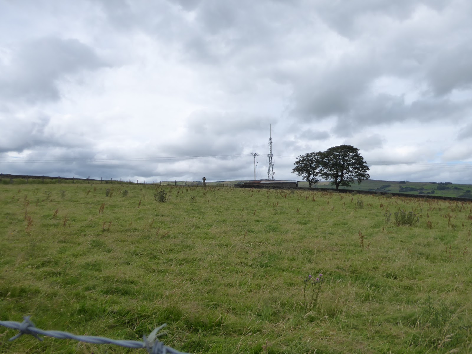
| Mankinholes Tops, with cross and mast. |
 |
| Mankinholes Youth Hostel. |
 |
| Lumbutts Methodist chapel. |
 |
| Lumbutts Mill and the roadworks on Lee Lane. |
Downhill feels like the order of the remainder of the day, heading down into the deep cleft of Lumbutts Clough and into the tree cover of Causeway Wood, snaking downwards with the shaded lane to meet the old millpond upstream from the now lost Old Royd mills, and also noting the cellar remnants of the Causeway Wood Hall, now mostly hidden by undergrowth at the roadside, ahead of our emergence below the high apron of the valley, which has a prominent rough edge, ahead of our turn towards Old Royd hamlet. The unadopted road rises to the terrace and house that were surely built for the mill site below, now forming their own little rural idyll beyond the edge of the town, which sits just up the valley, with Whirlhaw Stones looming above it, with our path becoming a secluded track that I'd mistaken for an actual road, leading us to the hamlet of Kilnhurst, which is fully absorbed into the urban spread of Todmorden, below the old hall and the toll house on the once private lane which we have just traversed. So it's downhill again, to shed the last of the accumulated altitude among the suburban growth that has sneaked as far up the valley side as it could, twisting down Kilnhurst Lane to meet the ranks of terraces in the older town, ahead of our passage over the Rochdale Canal at Kilnhurst Bridge, and thence meeting the Calder riverside beyond the Commercial Street terrace, looking a modest sort of stream at this quarter but still contained by high flood walls that are followed as we meet the main Calderdale valley road of the A646 at Stansfield Bridge. A riverside walk into the town feels like it ought to offer itself to us, but it's harder to get that was imagined, as River Street turns out to be a dead end, and the ongoing route has to be sought from the Rochdale Road, not immediately accessible from Anchor Street either and only available in part along Sackville Street, with passage otherwise being made along the Industrial Street terrace before finding the footpath beyond, which gives us our Calder views, and the confluence with Walsden Brook, on the run in to the Market Hall and place. This lands us at the junction of the Uppermost Calder, for the first time in 5 years, madly, landing on the Burnley Road by the Polished Knob, taking our town tour past the Neo-Classical (and over-large) Town Hall, the parish church of St Mary on its perch above the main road junction, and the Toy & Model museum opposite, ahead of the rise up Rise Lane behind the Queen Hotel to seal the day at Todmorden railway station at 4.40pm, just shy of 20 (twenty!) miles out from the start of the day, still standing after four valley ascents, four hillside crests and four valley descents and feeling mightily delighted that I achieved this in August, rather than the Spring conditions that it had originally been planned for.
 |
| Causeway Wood. |
 |
| Todmorden and Whirlhaw Stones, from Old Royd. |
 |
| The Downstream Calder and Commercial Terrace, Todmorden. |
 |
| The merging Walsden Brook, and Uppermost Calder, with Todmorden viaduct. |
 |
| Todmorden Town Hall, on the Burnley and Rochdale Roads corner. |
5,000 Miles Cumulative Total: 4544.9 miles
2020 Total: 278.4 miles
Up Country Total: 4081.9 miles
Solo Total: 4221.3 miles
5,000 in my 40s Total: 3138.7 miles
Next Up: The Holme valley to the Calder valley, because Why Not?
~~~
Pandemic Thoughts: Week 21
Yeah, I'm done with writing about this every week, you'll get my thoughts at the end of each month from now on, as trying to deal with it every time I blog is just too damn exhausting...


No comments:
Post a Comment