Greetland (Sunnybank), Barkisland, Slack, Ringstone Edge Reservoir, Scammonden Dam,
Bilberry Hill, The Mosses, Doe Holes, Deanhead Moss, Buckstones, March Haigh Reservoir,
The Dean, Hey Green and Tunnel End Reservoir.
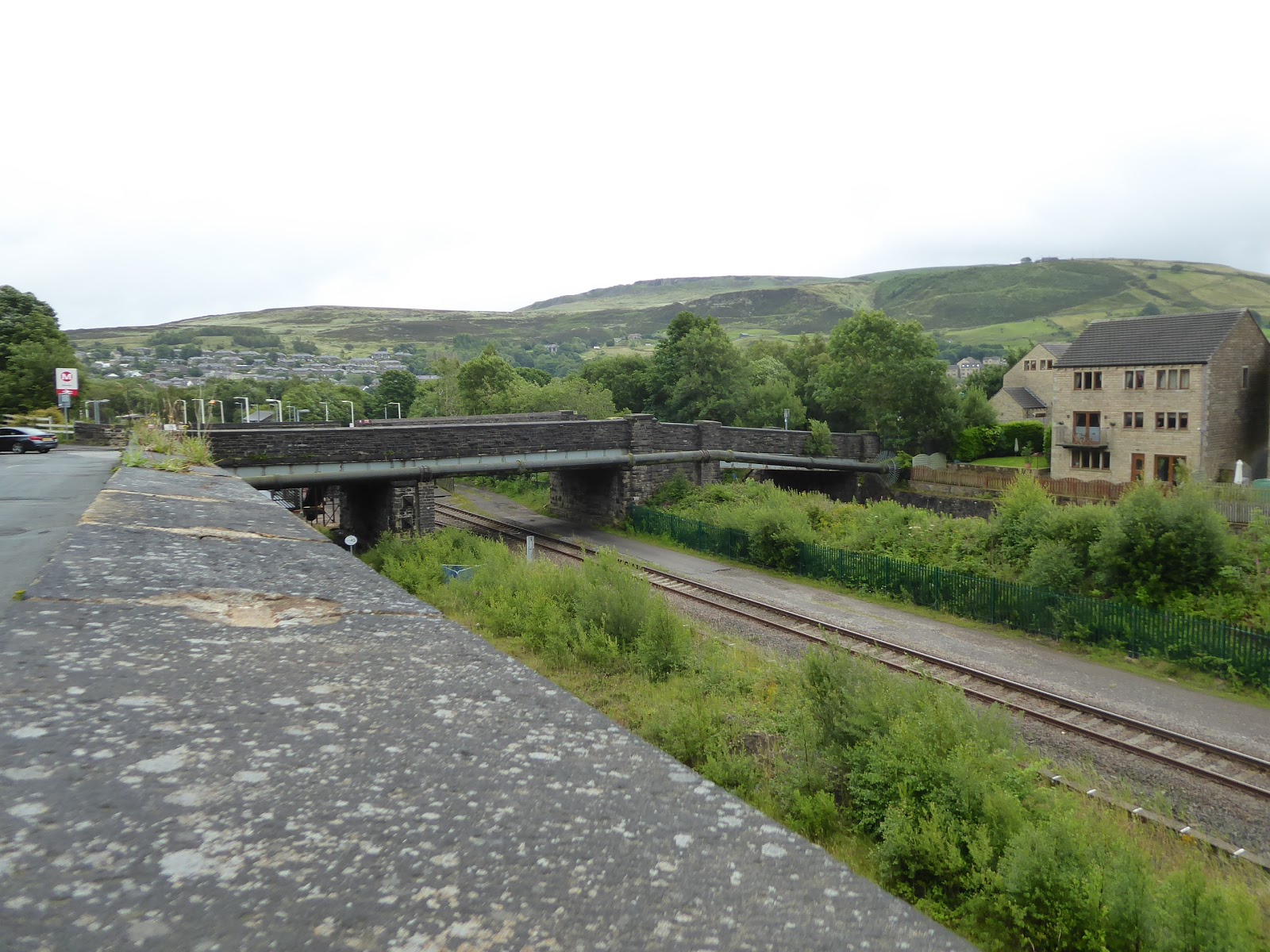
It's been a long time coming, and it might not be the wisest decision that I've ever made, but we are not living in age of wise cultural decisions at present, and thus after 4 months of lockdown and restricted walking, I'm ready to get back into my routine of proper walking for 2020 while I'm NIW, donning heavy boots again, and accepting the risks of travelling far from home, picking up the slate of walks that I'd hopefully scheduled for the Spring and hoping that Summer will last long enough to get them down, though if it continues in the vein of mixed up weather that it has so far, conditions other than a global pandemic might yet shut me down. So off on the train we ride, under grey skies that fail to scream 'July' at us, alighting at Brighouse at a measure ahead of 8.55am, with another trip from Calder to Colne on the schedule, shadowing my last excursion out back in March, and starting out from the A641 Huddersfield Road (which we visited at this year's opening), but not heading directly uphill as the roads down't align, instead slipping down to meet Cliffe Road, which shadows the river Calder between the two main road bridges, giving us sight of the climbing wall in the flower silo before we come upon Bridge End, where the railway line up the valley passes overhead on a five-arched viaduct that you's fail to acknowledge under any other circumstances. The A643, my hometown trunk road, will lead us on from here, with Bramston Street forming the initial stretch, up through the stone terraces of Brighouse's spread on the southern side of the river, leaving the growing apartment block on the corner in our wake as we press away, past the imposing chapel, the recreation ground and the suburban development in the roadside depression that was once filled by a dye works, getting a feel for just how sharp the landscape edge of this side of the valley are as Thornhill Road transitions us into Rastrick. This village is indelibly linked to its downhill neighbour, thanks to its infamous brass band heritage, and the centre of it lies ahead, with a short shopping parade sitting between the village school and St Matthew's church on a distinct kink in the road, and the pitch of the climb continues, as we transition among stone cottages and suburban semis on Crowtrees Lane, where the former mill sites have redeveloped and the outlying districts above the valley are passed though before the name of New Hey Road gives us something to grasp hold of, ahead of landing by the Sun Inn at Badger Hill, on the crossroads that we touched on our last solo trip far from home.
 |
| Brighouse Viaduct, hiding in plain sight. |
 |
| Ascending Thornhill Road from Brighouse to Rastrick. |
 |
| St Matthew's, Rastrick. |
Here, we thus shift westwards onto the B6114 Dewsbury Road, high above middle Calderdale, with the suburban outliers sitting among the elevated fields below the quiet roar of the nearby M62, and we get some nice views across emerging through the gaps towards Elland Park Wood before we enter the settlement of Elland Upper Edge, a remote village on the valley side that has retained a lot of its rural character, largely due to a lack of space for suburban growth, still sustaining a chapel and a pub, the Rock Tavern ahead of the revealing view down towards Elland proper and the converging valleys of the Calder and Blackburne. A grand place to absorb the surroundings and the view towards greater Halifax, though we'v hardly got the best conditions for it, with suggestions of rain coming in from the west and thus waterproofs are donned as the western horizon greys out, following the long steep decline above the enduring farmsteads and below the roadside cottages, ahead of the town's industrial and suburban band, shedding all the height gained early on as we come down to pass under the A629 Calderdale Way, and to enter the town beyond, among the converted and enduring mills and factories that line this end of it. We are lead in towards the centre but navigation has to be used to not send us up the Elland Riorges Link Road, instead scooting around the traffic island to trace another early season path that take us past the Southgates Methodist church and the old Town Hall, tracking in towards its heartland of shops before Victoria road swings us away from it, around the ends of the long terraces that split off to the south and up towards St Patrick's RC church and the Bethesda chapel, and it's worth noting the stucco clad terraced house beyond, which cries out for a colourful paint job, before we switch onto Jepson Lane. The long terrace here leads us up to the Wainwight Hall, the old Sun inn and the enduring Golden Fleece, which might well be the oldest pub in the town, ahead of us grazing that odd local landscape of tower blocks that terminates at the end of Westgate, beyond which we slip downhill again, as the decline below the wooded bank of Nab End leads us down the sheltered lane of Long Wall, leading us out of town and through the trees in close proximity to the river Calder once again, and leading us to the convergence with the B6114 Saddleworth Road, where a poor route decision ahead could easily be made if you were to slip onto the B6113, which would take you to Halifax or the completely wrong part of Greetland.
 |
| Elland Upper Edge. |
 |
| Dewsbury Road(?), above Elland, with the Blackburne and Calder valleys. |
 |
| Southgates Methodist Church and the old Town Hall, Elland. |
 |
| Long Wall, below Nab End. |
Back on our road of choice for the day, we pass among the terraces, mills and rag warehouses that sit at this corner of greater Halifax, namely West Vale, where we've also been before, forming a loop some six years back as we came down the the B6112 Stainland Road, and thence over the West Vale viaduct, when my idea of filling in the blanks of West Yorkshire were much less though than they are now, and this major relic of the L&YR's Holywell Green branch is that bit more visible now, thanks to some more mill remnants having been demolished, though it still manages to hide in plain sight once the Saddleworth road has passed below its northern end, obscured by trees and industrial units. We've now slipped into the Blackburne valley, as it is apparently named, having not seen its parent stream, Black Brook, at all as we passed over it in the town below, and as we set off up the northern valley side on the long drag of the B6114, we get the suburban face of Greetland, neatly named Sunnybank, filling in the rising side of the road, where old terraces and many newer semis have been developed to make best use of the view over to the ridge on which Stainland sits, with the other railway viaduct hiding among the trees off to the south, stretching all the way out to the old Ellistones farms and mill sites, terminating by Brian Royd mill, beyond which open countryside awaits. Still on a steady rise, the ongoing curve of this most hidden of valleys still manages to be beyond viewing, possibly being lost behind the waves of drizzle that keep coming in from the west, reminding us of the Pennines Proximity Problem (that the rain will come the closer you get to the hills, despite the forecast), and attention wanders up the north side of the valley that rises toward Calderdale, and the pleasing farmsteads that sit above us as we come past the workshops and former inn on the Branch Road corner, and start to get a feeling of remoteness as a wave of summer rain washes over us. It's going to be that sort of day it seems, as we get some cover below the trees and thick hedge that bound Bowers house, finally getting a landscape reveal above the farmsteads of Middle and Lower Barsey, with our route snaking up the high valley side ahead, while we look across to the Crow Edge hillside on the high south side, and also way upstream to the Worts Hill and Pole Moor uplands, teasing the proximity of Kirklees district on the far side of the ridge that hides the Colne Valley, though it's still a long way until we get there, with much more ascent to come.
The climb of the lane doesn't feel challenging as we slip below the hamlet of Greetland Wall Nook and up to the Stone Stile and Wood Royd farmstead, but my under-utilised legs clearly aren't going at full strength as an older lady burns me off on the rise up to the road angle at Sandfoot Clough, ahead of our route taking a sharp turn up towards the last outpost of habitation on this lane, as we meet the North Field terrace and the old vicarage house ahead of the village of Barkisland, which at over 230m up feels like it's at a good three or four steps removed from the nearest towns, but still manages to have attracted suburban growth and a council estate for the folks who like to be far away from so many others. It must be grandly remote in the good seasonal weather but must feel isolated at worse times, and I'll just assume the residents are hardier souls than myself, who'll regard the crossing roads of the only major routes through the Blackburne valley, as I pass, ahead of the parish War Memorial and the secluded Christ Church, behind its thick bank of trees, where a bench doesn't seem to be available for elevenses before the road climb continues, back among the fields and briefly settling onto the other side of the ridge which we travelling atop, which gives us a look to the high west side of the Ryburn valley, which is not quite as concealed a Calderdale valley as this one, as it does have two notable A-roads up it. The pavement ends as we approach the off-road hamlet of Slack, beneath the parade of pylons that are setting off on their trans-Pennine route over Rishworth Moor, and as we rise we can get a look back from the ridge to see both sides of it, but as we look ahead, hopeful of getting a full-length view of Great Manshead hill again, we seen rain coming over the hills at quite a rate, so we have to pull everything inside the waterproofs as we carry on to the next hilltop, not being afforded any shelter by the rise of Ringstone Edge moor, or any of the remote farmsteads by the roadside. At the leveling off point on the lane, we find an elevated reservoir, that of Ringstone Edge, which was built to supply Wakefield with water and is contained by embankments on both its side, with the lane following its eastern and southern sides around to its valve tower, with enough of dry verge and high wall at its edge for us to sit down to shelter from the rain and wind that's starting to feel most unseasonable, where we take an early lunch, as we get a feel for our newly regarded surroundings, not massively far from the M62 on its route over to Lancashire, or from the reservoirs on the Ryburn, as Baitings Dam can be spotted off to the west.
We've also hit moorland altitude now, having gotten above 300m up and passed the last few roads that tangle up with the B6114 before it sets its solitary course off to the southwest, and the way ahead should feel straightforwards from the rise away from the reservoir, but the signage indictaes that the Scammonden Bridge is closed for repairs and all traffic will need to make alternative arrangements, which is frustrating as passing over its span was a goal of this route, but we've a solid half mile more to traverse before we get there, the road rising above the bowl of the Royd Height quarry to the west and offering a fine look down to the head of the Blackburne valley, with Scammonden Dam blocking it off while also carrying the M62 across it. We are pushed from the road where the grassy footpath leads down to the old Scammonden Road below, where rural cottages enjoy the quiet isolation at the valley head, and our track leads us directly to the edge of the motorway and then sharply downhill to meet the dam top, easily locating the tunnel that passes silently beneath the carriageways, leading us out to the edge of Scammonden Water and entering Kirkless district, where we loop around to find the steep path back up towards road level, eschewing the plausible detour along the high western side of the reservoir to visit the lost village of Deanhead, or Scammonden. Rise up the side of the deep cutting of the M62 to admire the broad concrete span of the road bridge as it's a view we would have otherwise missed, the largest of its kind when constructed in 1967, and it seems that the construction activity going is on is for safety enhancements, but not because it is becoming structurally unsafe, in fact a new anti-suicide fence is being installed along its length, and it looks like they're going to be at that for a while, making route creation in this corner that bit more complicated in the fouture, but for now we've a solid hour of trek along the moorland top with Saddleworth Road to come. Despite having trailed the end of residential habitation a couple of times already, there are still a few outliers up here, with the Old Coach House having been a pub until not too long ago, now someone's plush house on the exposed moor as it's far too far away from any constituency of locals, or any passing traffic for that matter, ahead of the Mount Pleasant and Green Field Lodge pairing, which have fine views above the Deanhead Clough at the very least, with civilisation ending past the Moselden Height quarry and the last farmstead of all, The Delight.
At over 350m up, the character of the moor changes, with the walled enclosure abruptly ending, and New Lane offering the last alternative route away, down into the valley, which gives us a familiar look across having ventured into it in 2013 & 14, and after burning many new miles across the day, the route of the silent lane across the open lots of Bilberry Hill and The Mosses has us getting fed another dose of rain, which can get warning of as it rushes in from the west, as we scope out the look to the Colne Valley fringe behind us, seen so many times from other angles, as our road leads on, arrow straight and devoid of all traffic except that travelling purposefully to the bridge works. The West Riding styled mile posts will keep us company along here, giving us something to look for over this barren ridge, which doesn't give us a good feel for the proximity of Moss Moor edge and the upper Ryburn valley to our west, but we can look down to the east to see Deanhead Clough reservoir hiding down at the valley floor, while pressing on to the path route that brought us over here seven seasons back, our first path crossing since West Vale, illustrating just how much of West Yorkshire remain unseen and thus still needs to be visited on my walking travels. Moorland in its rawest form awaits on the long press up to the road junction, with stiles offering a route onto the access lands on both sides of the road, and that's still not something I feel to secure about doing, especially as we keep getting the weather coming on to grey out the horizon, and just as I was starting to scope out our location relative to sites on the south side of the Colne Valley ridge, which vanish from view as I become convinced that the summer of 2020 is mocking me and my walking choices as we come upon the road angle that counts as a feature after a solid mile walking in a straight line. This improves the angle of our view over Deanhead Clough, allowing us to sight both of the reservoirs below us, while we press on uphill over Deanhead Moss, still a way off the junction, with the clouds lifting occasionally to show that we are now significantly to the west of the mass of Meltham Moor, while also finding that a layby at the roadside has had a huge pile of furniture fly-tipped in it, showing the depressing amount of effort that some people will go to to do the wrong thing, but at least our path crest approaches, at over 450m up, showing us to the west of Pule Hill too as its sharp edge rises over the local horizon, as we finally come down onto the A640 on its Trans-Pennine passage.
It's a desolate and under used road these days, and as we meet the National Trust's car park above the headwaters of the Colne Valley, we can pause for a final refortification with provisions and admire the view up to the English Watershed, only a mile or so off to the west atop Blacker Edge, beyond the rise of March Hill, which looks like its suffered a Mam Tor-esque landslip in its past, while our route is presented straight downhill, on a steep and snaking path among the sharp gritstone boulders and outcrops of the Buckstones, which reach along this side of the valley, and amazingly having not been quarried out, as we shed height rapidly on a firm surface, aiming us down towards March Haigh Reservoir. It's still raining hard as we meet the fence and gate that separates us from the leveler stretch of moor, which is much more characteristically damp and muddy, picking our way down a path that doubles as a stream as we direct ourselves to the reservoir corner, passing over a pair of moorland ditches as we end our shedding of over 100m of altitude in a quarter hour's trudge ahead of landing on the shore with only a couple of running dogs, far from their owner, for company, and this shoreline in its natural bowl might be idyllic in pleasant weather, but that's not a day like today, and we'll make our turn for home from here, having come out some way to the west of Marsden. Two routes are available on the ground and map from the end of the run-off channel, and we'll pick the higher of these as it pushes away above Haigh Clough and the young river Colne, starting off with some purpose over an interceding stream but gradually losing definition, until it become indistinguishable from the long moorland grass around it, suggesting that no vehicles have traveled this way in a long while. Wisdom suggests a route change and we overland down to the lower path, that has a clear route at the edge of the clough, as boot height muddiness is entirely preferable to waist high grass dampness as we travel on tiring legs. It's a half mile or so to the nearest road, and we'll have Deer Hill and Pule Hill head of us as we press downstream, spotting the tunnel spoil still in place atop the latter as we are angled around the cloughs of the streams that feed the young river, with the rain and low cloud coming and going as we progress, which seems like its a recurring feature of this landscape having suffered variations of these conditions in 2013 and 2019 while traversing nearby paths, so it's a relief to finally rise and come up to the track to White Hall farm, getting us off the moorlands and giving us a clear path for the last miles of the day,
I don't think that the men with the van from the Canal & River Trust were anticipating meeting any walkers out there while they were doing their thing as I land back on a hard surface, finding that the road is going to be far from direct in getting me back to my finish line as it wanders its way through the farm cluster that maps call The Dean, setting off down the the bottom of the cleft of Green Owlers Clough before rising again past Lower Green Owlers farm, now in full rural getaway mode, and cresting over the level hill top on which Bank Top farm sits, looking so out-sized large that I wouldn't be entirely surprised to learn that it had once formed a small dissenting religious community. Our wandering route lands us above Close Gate bridge and the converging cloughs on the uppermost Colne, where our previous path out here set us off up the watershed, and we can also trace the passage of the A62 over to the Tame Valley as it sets off southbound on the west side of Pule Hill, and it's rather amazing that this expanse of moorland, which seems to form such a natural Pennine break with Lancashire used to be all part of the West Riding of Yorkshire until boundaries where redrawn in 1974, terrain that won't be seen any closer thanks to the truncation of the 2020 walking season. We'll turn our back on this landscape as we head down to meet our 2013 route as it splits off from Blake Lee Lane by the riverside, in the secluded vicinity of Hey Green house, with it's private access drive and bridge over the Colne to Manchester Road, as well as its parade of associated cottages and its preserved hydro that was the first electrical power plant in the valley, beyond which the remotest suburban ribbon of Marsden arrives along Waters Road, overlooking the permissive paths that trace the footprint of Tunnel End reservoir, which is mostly drained and forming a nature reserve these days, no longer needed to feed the Huddersfield Narrow Canal. We pass with the lane aobev the canal warehouse, and spy the old and current railway tunnels, with the Colne itself running over the line via an aqueduct, and as we carry on below the outlying terraces on the valley side and above the cutting, there's not a single train, Nova or otherwise, to be spotted as we come around to have the bulk of Deer Hill present above the town, which we won't be seeing up close as Marsden station is the day's destination, where we land at 3.05pm, happy to finally feel like 2020 has space for me to do my thing again and has now been taken back for my own personal entertainment, but less cheered by the fact that might right knee and hip are choosing this time to loudly object at being so exercised after not being tested hard for so long.
5,000 Miles Cumulative Total: 4493.8 miles
2020 Total: 227.3 miles
Up Country Total: 4030.8 miles
Solo Total: 4170.2 miles
5,000 in my 40s Total: 3087.6 miles
Next Up: Aiming at the sole West Yorksire station that I haven't visited so far.
 |
| West Vale viaduct, slightly more visible than it used to be. |
 |
| Sunnybank, Greetland. |
 |
| The Blackburne valley, looking east. |
 |
| The Blackburne valley, looking southwest. |
The climb of the lane doesn't feel challenging as we slip below the hamlet of Greetland Wall Nook and up to the Stone Stile and Wood Royd farmstead, but my under-utilised legs clearly aren't going at full strength as an older lady burns me off on the rise up to the road angle at Sandfoot Clough, ahead of our route taking a sharp turn up towards the last outpost of habitation on this lane, as we meet the North Field terrace and the old vicarage house ahead of the village of Barkisland, which at over 230m up feels like it's at a good three or four steps removed from the nearest towns, but still manages to have attracted suburban growth and a council estate for the folks who like to be far away from so many others. It must be grandly remote in the good seasonal weather but must feel isolated at worse times, and I'll just assume the residents are hardier souls than myself, who'll regard the crossing roads of the only major routes through the Blackburne valley, as I pass, ahead of the parish War Memorial and the secluded Christ Church, behind its thick bank of trees, where a bench doesn't seem to be available for elevenses before the road climb continues, back among the fields and briefly settling onto the other side of the ridge which we travelling atop, which gives us a look to the high west side of the Ryburn valley, which is not quite as concealed a Calderdale valley as this one, as it does have two notable A-roads up it. The pavement ends as we approach the off-road hamlet of Slack, beneath the parade of pylons that are setting off on their trans-Pennine route over Rishworth Moor, and as we rise we can get a look back from the ridge to see both sides of it, but as we look ahead, hopeful of getting a full-length view of Great Manshead hill again, we seen rain coming over the hills at quite a rate, so we have to pull everything inside the waterproofs as we carry on to the next hilltop, not being afforded any shelter by the rise of Ringstone Edge moor, or any of the remote farmsteads by the roadside. At the leveling off point on the lane, we find an elevated reservoir, that of Ringstone Edge, which was built to supply Wakefield with water and is contained by embankments on both its side, with the lane following its eastern and southern sides around to its valve tower, with enough of dry verge and high wall at its edge for us to sit down to shelter from the rain and wind that's starting to feel most unseasonable, where we take an early lunch, as we get a feel for our newly regarded surroundings, not massively far from the M62 on its route over to Lancashire, or from the reservoirs on the Ryburn, as Baitings Dam can be spotted off to the west.
 |
| Stone Stile farm. |
 |
| Barkisland and the crossroads. |
 |
| The rise to Slack Hamlet, on the Blackburne - Ryburn ridge. |
 |
| Ringstone Edge Reservoir. |
We've also hit moorland altitude now, having gotten above 300m up and passed the last few roads that tangle up with the B6114 before it sets its solitary course off to the southwest, and the way ahead should feel straightforwards from the rise away from the reservoir, but the signage indictaes that the Scammonden Bridge is closed for repairs and all traffic will need to make alternative arrangements, which is frustrating as passing over its span was a goal of this route, but we've a solid half mile more to traverse before we get there, the road rising above the bowl of the Royd Height quarry to the west and offering a fine look down to the head of the Blackburne valley, with Scammonden Dam blocking it off while also carrying the M62 across it. We are pushed from the road where the grassy footpath leads down to the old Scammonden Road below, where rural cottages enjoy the quiet isolation at the valley head, and our track leads us directly to the edge of the motorway and then sharply downhill to meet the dam top, easily locating the tunnel that passes silently beneath the carriageways, leading us out to the edge of Scammonden Water and entering Kirkless district, where we loop around to find the steep path back up towards road level, eschewing the plausible detour along the high western side of the reservoir to visit the lost village of Deanhead, or Scammonden. Rise up the side of the deep cutting of the M62 to admire the broad concrete span of the road bridge as it's a view we would have otherwise missed, the largest of its kind when constructed in 1967, and it seems that the construction activity going is on is for safety enhancements, but not because it is becoming structurally unsafe, in fact a new anti-suicide fence is being installed along its length, and it looks like they're going to be at that for a while, making route creation in this corner that bit more complicated in the fouture, but for now we've a solid hour of trek along the moorland top with Saddleworth Road to come. Despite having trailed the end of residential habitation a couple of times already, there are still a few outliers up here, with the Old Coach House having been a pub until not too long ago, now someone's plush house on the exposed moor as it's far too far away from any constituency of locals, or any passing traffic for that matter, ahead of the Mount Pleasant and Green Field Lodge pairing, which have fine views above the Deanhead Clough at the very least, with civilisation ending past the Moselden Height quarry and the last farmstead of all, The Delight.
 |
| Scammonden Dam, and Reservoir. |
 |
| Downstream on the Blackburn, from Scammonden Old Road. |
 |
| The Passage below the M62. |
 |
| Scammonden Bridge. |
 |
| The Old Coach House, and company, Saddleworth Road. |
At over 350m up, the character of the moor changes, with the walled enclosure abruptly ending, and New Lane offering the last alternative route away, down into the valley, which gives us a familiar look across having ventured into it in 2013 & 14, and after burning many new miles across the day, the route of the silent lane across the open lots of Bilberry Hill and The Mosses has us getting fed another dose of rain, which can get warning of as it rushes in from the west, as we scope out the look to the Colne Valley fringe behind us, seen so many times from other angles, as our road leads on, arrow straight and devoid of all traffic except that travelling purposefully to the bridge works. The West Riding styled mile posts will keep us company along here, giving us something to look for over this barren ridge, which doesn't give us a good feel for the proximity of Moss Moor edge and the upper Ryburn valley to our west, but we can look down to the east to see Deanhead Clough reservoir hiding down at the valley floor, while pressing on to the path route that brought us over here seven seasons back, our first path crossing since West Vale, illustrating just how much of West Yorkshire remain unseen and thus still needs to be visited on my walking travels. Moorland in its rawest form awaits on the long press up to the road junction, with stiles offering a route onto the access lands on both sides of the road, and that's still not something I feel to secure about doing, especially as we keep getting the weather coming on to grey out the horizon, and just as I was starting to scope out our location relative to sites on the south side of the Colne Valley ridge, which vanish from view as I become convinced that the summer of 2020 is mocking me and my walking choices as we come upon the road angle that counts as a feature after a solid mile walking in a straight line. This improves the angle of our view over Deanhead Clough, allowing us to sight both of the reservoirs below us, while we press on uphill over Deanhead Moss, still a way off the junction, with the clouds lifting occasionally to show that we are now significantly to the west of the mass of Meltham Moor, while also finding that a layby at the roadside has had a huge pile of furniture fly-tipped in it, showing the depressing amount of effort that some people will go to to do the wrong thing, but at least our path crest approaches, at over 450m up, showing us to the west of Pule Hill too as its sharp edge rises over the local horizon, as we finally come down onto the A640 on its Trans-Pennine passage.
 |
| Saddleworth Road assails the high moors. |
 |
| The path previously traveled to the Ryburn Valley. |
 |
| Looking back down Deanhead Clough to the reservoirs and Colne Valley hill tops. |
 |
| Fly-tipping on the moors. (You are a special king of asshole, if you would do such a thing) |
It's a desolate and under used road these days, and as we meet the National Trust's car park above the headwaters of the Colne Valley, we can pause for a final refortification with provisions and admire the view up to the English Watershed, only a mile or so off to the west atop Blacker Edge, beyond the rise of March Hill, which looks like its suffered a Mam Tor-esque landslip in its past, while our route is presented straight downhill, on a steep and snaking path among the sharp gritstone boulders and outcrops of the Buckstones, which reach along this side of the valley, and amazingly having not been quarried out, as we shed height rapidly on a firm surface, aiming us down towards March Haigh Reservoir. It's still raining hard as we meet the fence and gate that separates us from the leveler stretch of moor, which is much more characteristically damp and muddy, picking our way down a path that doubles as a stream as we direct ourselves to the reservoir corner, passing over a pair of moorland ditches as we end our shedding of over 100m of altitude in a quarter hour's trudge ahead of landing on the shore with only a couple of running dogs, far from their owner, for company, and this shoreline in its natural bowl might be idyllic in pleasant weather, but that's not a day like today, and we'll make our turn for home from here, having come out some way to the west of Marsden. Two routes are available on the ground and map from the end of the run-off channel, and we'll pick the higher of these as it pushes away above Haigh Clough and the young river Colne, starting off with some purpose over an interceding stream but gradually losing definition, until it become indistinguishable from the long moorland grass around it, suggesting that no vehicles have traveled this way in a long while. Wisdom suggests a route change and we overland down to the lower path, that has a clear route at the edge of the clough, as boot height muddiness is entirely preferable to waist high grass dampness as we travel on tiring legs. It's a half mile or so to the nearest road, and we'll have Deer Hill and Pule Hill head of us as we press downstream, spotting the tunnel spoil still in place atop the latter as we are angled around the cloughs of the streams that feed the young river, with the rain and low cloud coming and going as we progress, which seems like its a recurring feature of this landscape having suffered variations of these conditions in 2013 and 2019 while traversing nearby paths, so it's a relief to finally rise and come up to the track to White Hall farm, getting us off the moorlands and giving us a clear path for the last miles of the day,
 |
| March Haigh reservoir from the Buckstones car park |
 |
| The path down through the Buckstones. |
 |
| March Haigh Reservoir, and March Hill. |
 |
| Haigh Clough and the young Colne, with Pule Hill. |
I don't think that the men with the van from the Canal & River Trust were anticipating meeting any walkers out there while they were doing their thing as I land back on a hard surface, finding that the road is going to be far from direct in getting me back to my finish line as it wanders its way through the farm cluster that maps call The Dean, setting off down the the bottom of the cleft of Green Owlers Clough before rising again past Lower Green Owlers farm, now in full rural getaway mode, and cresting over the level hill top on which Bank Top farm sits, looking so out-sized large that I wouldn't be entirely surprised to learn that it had once formed a small dissenting religious community. Our wandering route lands us above Close Gate bridge and the converging cloughs on the uppermost Colne, where our previous path out here set us off up the watershed, and we can also trace the passage of the A62 over to the Tame Valley as it sets off southbound on the west side of Pule Hill, and it's rather amazing that this expanse of moorland, which seems to form such a natural Pennine break with Lancashire used to be all part of the West Riding of Yorkshire until boundaries where redrawn in 1974, terrain that won't be seen any closer thanks to the truncation of the 2020 walking season. We'll turn our back on this landscape as we head down to meet our 2013 route as it splits off from Blake Lee Lane by the riverside, in the secluded vicinity of Hey Green house, with it's private access drive and bridge over the Colne to Manchester Road, as well as its parade of associated cottages and its preserved hydro that was the first electrical power plant in the valley, beyond which the remotest suburban ribbon of Marsden arrives along Waters Road, overlooking the permissive paths that trace the footprint of Tunnel End reservoir, which is mostly drained and forming a nature reserve these days, no longer needed to feed the Huddersfield Narrow Canal. We pass with the lane aobev the canal warehouse, and spy the old and current railway tunnels, with the Colne itself running over the line via an aqueduct, and as we carry on below the outlying terraces on the valley side and above the cutting, there's not a single train, Nova or otherwise, to be spotted as we come around to have the bulk of Deer Hill present above the town, which we won't be seeing up close as Marsden station is the day's destination, where we land at 3.05pm, happy to finally feel like 2020 has space for me to do my thing again and has now been taken back for my own personal entertainment, but less cheered by the fact that might right knee and hip are choosing this time to loudly object at being so exercised after not being tested hard for so long.
 |
| White Hall farm, and The Dean. |
 |
| Close Gate bridge and the passage of the A62. |
 |
| Tunnel End Dam and Cottages, and the Pule Hill Spoil Heap. |
 |
| Deer Hill, and company, above Marsden. |
5,000 Miles Cumulative Total: 4493.8 miles
2020 Total: 227.3 miles
Up Country Total: 4030.8 miles
Solo Total: 4170.2 miles
5,000 in my 40s Total: 3087.6 miles
Next Up: Aiming at the sole West Yorksire station that I haven't visited so far.
No comments:
Post a Comment