 |
Long Distance Trail means
Selfies! #7 at the Hercules
Revived, Sutton Cheney.
|
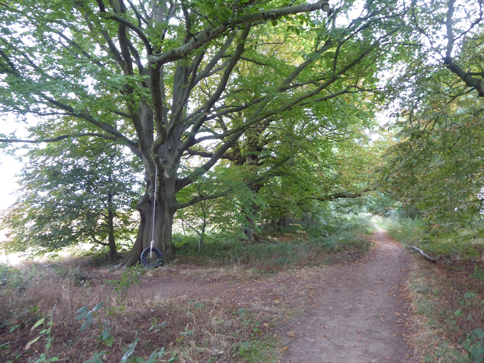
A relatively chilled couple of days drop in between my trekking days, with nothing more active than having My Sister and her family drop by for lunch while passing through on a cross country jaunt, and getting My Parents over to the church dinner club the following day, knowing that the gardening exploits are due once my walking days are finished, so I feel decently recharged once my second 17 mile jaunt of my Down Country break comes around. Unfortunately, after six clear runs to my start points on the Round, the seventh and final one is the longest trip of all, which forces us through Leicester's morning rush hour traffic, preventing a very early start and meaning that we don't get our jump off in Sutton Cheney until 9.05am, with the skies suggesting coming blueness in the west, but general grey pudding hanging over the rest of the county. Depart from the Hercules Revived public house (a name I really can't get enough of), and roll up Main Street, through a village that would surely glow red on a sunnier day thanks to all it construction in brick, passing the Old Hall that is plainly the most impressive structure in the village, running up as far as the Royal Arms Hotel, the other village pub that has a sideline as an actual hotel complex, and our route passes through its car park and into the fields beyond. Trace a bunch of boundaries as we tack to the northwest, which will be our trajectory for the next 5 miles, noting that we are passing though enclosures that were growing beans, judging by the quantity still on the ground post-harvest, rising towards Spring Wood and Woodhouse farm whilst feeling a light regret that the Round doesn't pass through Cadeby, a mile or so inside its path, where the Reverend Teddy Boston used to famously operate a narrow gauge railway in the Rectory Garden. The path leads us into Bosworth Park, once the extensive parklands of Bosworth Hall, seat of local benefactors, and general oddballs, the Dixie family, where we follow a tree lined avenue that leads among the open meadows and small spinneys, still looking the same as the would've a century ago, for a solid half mile before we arrive in the public park at the top end. Meet the local exercisers and strollers here as our route tracks around the shaded memorial garden and the Bow Pool before meeting the open parklands as we run in towards Rectory Lane, with both Bosworth Hall and St Peter's church just beyond the passage of the Round path as we enter Market Bosworth.
 |
| The Old Hall, Sutton Cheney. |
 |
| Field Walking to Spring Wood. |
 |
| The Avenue of Trees, Bosworth Park. |
 |
| Bow Pool, Bosworth Park. |
This is one of those large villages that really fancies itself as a town, of which this county has many, but it does make its case well as we pass the old rectory and pass around the corner to the Market Place, where the market is in session and the scale of the late Georgian shop fronts and the bulk of Dixie's Grammar School certainly make it look like an imposing centre, and it also knows that it's more than just the local centre of gravity, sharing half the district name with Hinckley, while displaying its links to the events of 1485 that have probably aided keeping in in bread for centuries. It's certainly very lovely and well dressed, though I can't be certain that I ever visited before, despite at least three trips to the battlefield ever, but we need to move on, down Back Lane between the village surgery and secondary school, to soon find the field path that will skirt us around the suburban west of the village, situated here for the best placed gardens in the afternoon sunshine, pacing around through the rough plots to meet a green lane at the village's extremity, where we can look back to the spire of St Peter's church, feeling sure that this is one that will linger on the horizon. Heading northwest again, the lane ends and runs into the edge of King's Golf course, tracing a grassy ditch between the fairways to right and left, looking somewhat devoid of life and rather uncared far, altogether one of the roughest looking courses that I've encountered, finding the passage off of it as we meet Mill Covert, crossing a stream and a rough meadow to get onto the course towards Carlton, one of those village names that every county seems to have. Trace a long boundary through another field that appears to be growing fodder crops, with only half the village to come visible thanks to the thick hedges on our right, eventually arriving on the western end of Main Street, where residential growth has claimed most of the gaps between the older houses, though charm is still strong around the old village school and the cluster of farmsteads around Shackerstone Walk. I'm certainly seeing a lot of place that will need a revisit as I go, as we head into the fields again, meeting a combine harvester bringing in the oats crop from the fields around the village, before the field boundary paths lead us on to grassy pasture and wide open fields that have been thoroughly harrowed recently, where we are ringed by a level horizon, surrounded by scattered copses of trees, with tower of St Andrew's Carlton and St Peter's Market Bosworth on the receding skyline. Clear going towards Shackerstone is then interrupted as I enter a field of cows, mostly grazing around the remotest corner of the field, who seem undisturbed by my presence until one excitable Friesian decides to hurry over to take a closer look at me, causing the whole herd to hurry over towards the field exit point behind me, and I have to run to get there before them, which is more alarm than I need as I force the pulse to settle as I stroll the last field over to Long Covert and Congerstone Road.
 |
| The Market Place, Market Bosworth. |
 |
| The green lane, and the spire of St Peter's, Market Bosworth. |
 |
| King's Golf Course. |
 |
| The Village School, Carlton. |
 |
| Racing the Cows, between Carlton and Shackerstone. |
Water break by the remote Keepers Cottage and then field walk again, to the corner of Orange Hill plantation, to meet the path redirection, which has been in place for a decade now due to the footbridge at Shackerstone station being unsafe, visible across the field at the head of the Battlefield Line, the preserved railway that has always played second fiddle to the GCR since its creation in 1970, and the detoured path to the Barn Farm access road gives us a view to Bardon Hill, distant in Charnwood Forest with half of it mass clearly missing due to quarrying. Descend to pass underneath the railway at Shackerstone Junction (of the L&NWR/MR joint line from Nuneaton to Ashby of 1973-1965) and then get no closer to Shackerstone village than the Turn Bridge on the Ashby canal, the path of which we join for a second time as we pass the wharf that has grown by the canalside farm, but only enjoy the briefest of dalliances with it before we leave the westernmost extremity of the Round and start the eastern leg to the finish line. That's nine legs of the guidebook's version done too as we interact with the old railway once more, rising over the embankment of the line to Measham and Ashby, which now forms the Battlefield Line's access road, before descending to meet the fields between the lines and then pass under the branch that once split off to serve Coalville and the Charnwood Forest Line to Loughborough. Beyond here we meet the problem of the largest herd of dairy cows met so far on all my travels, in the enclosure that I have to walk through the middle of, a big enough group to give me severe anxiety about getting slightly close to them, and not having an alternative route to take, I press forward with purpose and while these multitudinous bovines do get vocal and mobile, they don't get agitated and I've never been happier to meet an electric fence that prevents them following me and allows me to make in out of their field unmolested. The stretch around Shackerstone starts to feel like a loop that has merely added distance to the round route as we join the field path that gradually works us forwards and uphill towards Odstone, giving us some contextual views to the northwest and keeping us away from one of the best named villages in the county, Barton in the Beans, which the Round path avoids on three sides as we link up with the local circuit of the Ivanhoe Way. Follow a tractor as harrows the neighbouring fields, attended by its own vast company of gulls, before the rising path levels off to pass in front of Odstone Hall, Georgian and redbrick above its ha-ha, and then on to meet Odstone proper beyond Ivy House farm, looking hamlet-sized as it shows to us two vintages of social housing, newer and council owned on Hall Lane; older and agriculturally tied on Smithy Lane.
 |
| Shackerstone station, the Battlefield Line. |
 |
| The Turn Bridge and Shackerstone Wharf, Ashby Canal. |
 |
| Too Many Bloody Cows, by the old L&NWR/MR joint line. |
 |
| North West Leicestershire, with many, many gulls. |
 |
| Odstone Hall. |
Descend from this hilltop settlement via Barton Road, splitting off into the fields before we get even slightly close to the village to the south of here, meeting a field track that rises to join the rough path that sets course across a couple of fields full of potatoes, which does get you wondering that if beans hadn't been the famous staple crop in these parts back in the day, the village to the south of here might have been named Barton in the Spuds? Pass over a stream and rise up through a pair of meadows to meet Green Lane, one of the county's forgotten country roads, and then it's back into the potato fields again as we continue over the rise towards Nailstone, meeting a trio of farm workers who have parked their heavy machinery on our track while they are collecting their extensive watering apparatus that has been spread across the field, suggestive that harvest season is due, left in our wake as we join the fields of other root vegetables beyond the woods of Nailstone Gorse. The spire of Nailstone church sits on the high ground to our east as we press on over the fields, seeing the A447 cutting a distinct ribbon over the landscape as it runs north towards Ibstock, and also looking towards Hollow Farm in its distinctive square plot, and seeing Bardon Hill displaying its broken profile on the horizon once again. Through the wheat stubble plot and on to cross the A447 and run on into Nailstone along Vero's Lane, beyond the small estate of council houses to land on the Main Street, just down from the former Queen's Head inn, which displays a sign that also names it the Nut & Squirrel, and our path leads down to the church through the suburban arrivals to arrive below the bulky All Saints church, with its massive brooch spire, where we will stop for lunch as the half way point on the day has come. Nailstone seems to be not as big a village as I was expecting, but blends its older cottages and newer arrivals rather well, admired as we resume down Church Road and strike into the fields again, crossing one enclosure of pasture before we get landed in multiple fields of corn, and as it has grown to mature height there's no way to see where you are headed when you are as short as I am. At least we can see where we are from the field boundaries, while the path cut is distinctly un-straight to add to the confusion, making you note why cornfields are such an effective staple for horror movies, thankfully leaving them behind after more than half a mile as we emerge into the open field by the B585 Bagworth Road, which runs southwards to the major suburban villages of West Leicestershire, such as Barlestone, Newbold Verdon and Desford, all of which are hidden from here as we press on along the field boundary around Crown farm.
 |
| Potato field walking. |
 |
| Field walking to Nailstone. |
 |
| All Saints, Nailstone. |
 |
| Cornfield walking, away from Nailstone. |
 |
| Crown Farm, and the blue sky teasing us. |
Descend with the hedge, admiring the wind turbine turning away to the south of us, and receiving the lunchtime phone call that allows me to give a progress report to My Parents, meeting the stream at the edge of Underhills Wood, and as we are on the boundary of both the former northwest Leicestershire coalfields and the contemporary National Forest, it's tough to immediately recognise which sites might be a reclaimed colliery or a contemporary plantation, and despite the fact it looks a lot like the former, it is most probably the latter. The rising fields beyond do give us our last look over the western portion of the county that we've spent the last 4+ hours in, as well as teasing us with the blue skies that have lingered to the northwest without ever arriving over the trail, despite all the wind movement, as we progress east along the field edges, feeling pretty sure that the plantations to the north are on the sires of the former Nailstone and Bagworth collieries, as we move on towards the village namesake of the latter. We meet Bagworth via the side of Barlestone Road and the perimeter of Recty Wood, and it could easily be mistaken for a rural village with suburban additions like so many others, but the terraces and working men's club on Station Road are indicative of an intermediate industrial heritage, and the major scar on the village is the loss of its Medieval church, demolished after damage by mining subsidence, the subsequent replacement having also gone as we see as our path takes us around and through the churchyard. Deep into National Forest territory now, we set a course south through Bagworth Wood, where the route is clearer than it appears on the map and a local dog being walked feels hopeful that I might have some spare lunch for it, which I don't, and move out onto Heath Road to meet our passage into Manor Wood, a much more extensive plantation that offers paths in many direction to be traversed or jogged, which might be confusing if it wasn't for the fact of our path progressing over the undulations below the tree cover in a straight easterly direction. We land by the Leicester - Burton line, partly the oldest railway in the county, and still active thanks to the quarry workings to the north of here, which we cross before dropping through the fields down to Thornton Mill, where we pass over its stream and millrace, and I'm struck just how many mill sites we seem to have encountered on the path of the Round, for they're features of the county that I'd never really been aware of. Mill Lane isn't to be walked up into Thornton (another village name that gets everywhere), and the footpath head over a sloped paddock and into the suburban close of Hawthorn Drive, which we follow up to the Main Street, where terraces again show its heritage of mining, but we don't linger long here as we quickly drop down the other side of the ridge that village sits on, past the Primary school where the kids seem to be playing All-in Cricket in the yard.
 |
| Underhills Wood. |
 |
| Colliery Terraces, Station Road, Bagworth. |
 |
| Bagworth Wood. |
 |
| Manor Wood. |
 |
| Main Street, Thornton. |
Down through the playing fields we head, with Markfield as our next target, so the last stretch feels definably imminent, and the path touches the very furthest end of Thornton Reservoir as we head north, passing around the reed filled lagoon at its western end, and we'll have to take a detour to see more of the first reservoir built in the 19th century to service Leicester's fresh water needs, and even from our vantage point half its mass stands on the arm stretching north with its 2.5 mile perimeter being a temptation for another day. We've another rise to negotiate, as this day keeps on bringing them despite their modest heights, heading up across the fields of barley to enter Browns Wood, another plantation of the National Forest, which looks like it has a good 20 years of maturity under its belt as it stretches over this hillside for what feels like half a mile, before we get ejected into a grassy depression with fields of cattle to negotiate through, though these brown bovines will ruminate at a distance, which is grand as I'm in I no mood to run away from them uphill. A plantation awaits next up, surprisingly, though neither guidebook nor signage seem to give it a name, but there's another broad path to follow as it drops to cross another shaded stream before rising again towards the sound of the motorway, not offering any guide posts until we are out into open fields, where another herd of caw and calves sit right across the path, but this time my attempt to give them a wide berth does have the desired effect of not disturbing them at all. Onwards across plots by the M1, that really is as loud as the guide says, traversing three before we meet the track that passes below it and would then guide us up to Markfield if we were to follow it but the Round path thinks that field paths are more pleasant and less muddy, which they probably are as it detours us through three more rising field, just like it dis on our approach to Barwell, landing us in the suburban perimeter at the close of Croftway, which we rise up through to meet London Road by the Bulls Head inn, where we break for water and a time check. Still on schedule, we then move onto Main Street, to pass the point where my early season trek wound up, closing the Round loop an hour early, not that I'll be counting any short cuts today as we press on north, past Trinity Church and the village green and on up the main drag that I have now seen all of on my travels, looking much the same as before though I'm sure it's got a bigger Co-op than it did in 2013. I wouldn't want to live here among the suburban splurge, but scoring a cottage on Main Street would certainly feel like a win as there are so many lovely ones up here in whitewash or granite, and it would have been a decent pub crawl back in the day too, having had four along the drag from London Road to Leicester Road until recently.
 |
| Thornton Reservoir. |
 |
| Browns Wood. |
 |
| Un-named Plantation, near Markfield. |
 |
| The Bulls Head, Markfield. |
 |
| The Congregational Chapel and the Old Rectory, Markfield. |
Past Town Head equestrian farm, we join the path that dives under the A50 bypass, completing our traversal of every major route that runs through the county (probably), and set course for the last hour through the wooded enclosure along the side of the A Road, before dropping us into an enclosure of birch trees and wild undergrowth that never quite advertises the path clearly, but as we keep pressing east we get sight of the War Memorial end of Old John Hill that gives the hint that we're going the right way as the path drops through brambles that stand shoulder high. Into clear fields beyond that, rising among the fields of sheep on the way up to Cover Cloud wood, giving us a northern aspect that shows up the high rolls and ancient woods of Charnwood Forest, with the distinctive masts at Copt Oak rising above them and Chitterman Hills farm looking idyllic at the centre, a view that finally brings hints of the sunshine that we've been denied these last six hours. Pass though the new forest plantation that edges onto Brown's Hay grasslands and arrive on the edge of the equestrian enclosures of Tangle Trees farm, passing the grazing horse and through the jumping field before arriving on the driveway between the stables and the barn, where the dogs aren't happy to have a guest, and our course leads beyond onto the track alongside John's Lee wood (not John Lee's wood, as your brain surely read it). The old woodland to the north is home to a Scouts' camp, which may also be associated to the nearby glamping pods, and the plantation to the south is newer, another addition to the National Forest, as it the Bailey-Sim wood that lies beyond, where bilberries grow by the path to offer sustenance to those who've had enough after a half mile of woodland walking (and who don't know the finish line is less than a mile distant), with Newtown Linford village even closer than expected beyond the last pair of open pasture walks for the day. Emerge onto Markfield Road by the last few semis in the village and join Main Street as it presses down through the most desirable village street in the western half of the county, where even the new additions harmonize well in this landscape of thatch, redbrick, whitewash and and granite, noting that there is a second pub here, named the Linford (not after Mr Christie, though), just up the lane from the Bradgate, confirming that I'm not wrong when I mix the names up. Pass the Primary school, just after kicking out time, and traverse around the cricket field and the offers of refreshment in the Old Post Office café and the Jade Tearooms, to arrive at All Saints church once again to pass the Leicestershire Tardis and arrive at the gates of Bradgate Park at 4.05pm, to close the loop on the Leicestershire Round mere minutes ahead of the arrival of my Parental Taxi.
 |
| The 'Other' end of Old John Hill. |
 |
| Charmwood Forest from Cover Cloud wood. |
 |
| John's Lee Wood, and plantation. |
 |
| Newtown Linford, where even the suburbia looks good. |
 |
| All Saints, Newtown Linford, where the Round loop closes. |
POSTSCRIPT: After seven walking days, spread over more than three months, that's my longest Long Distance Trail completed, with over 105 miles put down with all the various digressions off the route, an equivalent distance of trekking from Leicester to Leeds, or to London to put that distance into perspective, a route that has had me seeing about as much completely unknown territory in the county of My birth as all my days around the West Riding have this year. I'd never had any doubt that my legs would carry me around it, despite the fatigue that has been gripping me hard through the back half of the summer, and the fact the we had logistical issues that had My Mum running the Parental Taxi for close on 200 miles across the county, but most importantly all three of us made it, as we'd had our doubts about it happening back in May and even as recently as July. Indeed, Dad is still with us, having securely slept in when we travelled out in the mornings and managing to come out for six of my pick up journeys, only missing out on one because his bi-weekly visitor from Loros was in attendance, despite the physical issues that afflict him with the onset of Parkinson's disease, and it means the world to me to be able to celebrate the conclusion of the trail with him in attendance as we take tea and cake at Bradgate Park's Conservatory Tearooms. His chatty days may have ended as his speech has gotten less and less comprehensible, and he's not even particularly demonstrative in his demeanour, but put a mug of coffee and a thick slice of cake in front of him and he'll demolish it with alacrity, which shows that My Old Dad is still in there, regardless of how difficult it can be to reach him, or for him to reach us, at times. As for the future, who knows? We can really only speculate on what might happen next or how long My Dad might endure in his condition, I can only speak for myself and all other thoughts on that matter aren't for a public forum, so I know that I immediately need a rest from the trail as this Summer has burned me out and the plans I'd cast for the rest of the year are unlikely to happen, and I've no idea at all if I can speculatively plan for a Long Distance Trail for 2019 as the Parental Taxi's availability in 8+ months time is unknown. I do know that Leicestershire still has plenty to offer as 100+ miles of Round Path took me nowhere near many of the towns that ring the county, like Melton Mowbray, Lutterworth, Coalville or Ashby de la Zouch, so I'll certainly be seeking more paths when I am Down Country again, but I won't be doing any more miles in Pair of Boots #5 though, as they've tested me on the whole circuit around the county, and if they were done before 2017's season closed, they are certainly far beyond further usage now, surely only suitable gardening exploits from now on.
 |
Long Distance Trail means Selfies!
#8 & final, at Bradgate Park.
|
 |
| We All Made It! Celebratory Tea with My Parents at the Conservatory Tearoom. |
 |
| The Last Act for Pair of Boots #5, having given me 100 miles more miles than they owed me. |
5,000 Miles Cumulative Total: 3549.4 miles
2018 Total: 436.9 miles
Up Country Total: 3156.3 miles
Solo Total: 3263.1 miles
Miles in My 40s: 2143.2 miles
Next Up: A Rest, and most probably trashing all my Late Season plans.


No comments:
Post a Comment