11 miles, via Burley, Kirkstall, Hawksworth, Horsforth, Rawdon & Yeadon.
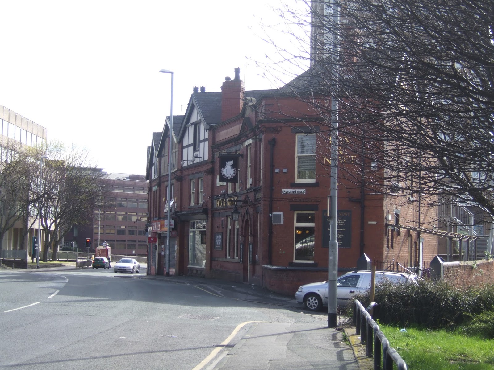
A nice weekend off to start the month, drinking and socialising, returning to the trail on that weekend, the second one in April, where I always feel there's a shift in the air temperature and it actually starts to feel like Spring, and the initial suggestions for today are good, with clear skies and plenty of sunshine, but as soon as that wind from the north-west cuts in, it's evident that wintery feelings might be around for a while yet. At least starting out from the Big City might keep some extra warmth in the air, starting out from Leeds station at 10.05, and immediately heading from the Aire Street exit to head down Whitehall Road to seek out the other remnants of Leeds Central station, still enduring since its closure, notably the remains of the passageway leading into the station hotel, and the wagon hoist that remains in the midst of the Wellington Place office park, an odd survivor that is treated with due reverence, though it's frustrating that there are no good angles on the approach viaduct from this quarter. Set the north-western course by heading across Wellington Street and up Lisbon Street, past the desolate site of the International Swimming Pool, and over the Inner Ring via the footbridge that leads to the knot of council houses around Duncombe Street. Rising to Burley Street we take an interest in passage of the many terraces that once endured between Burley Road and Kirkstall Road but were swept away by the city planners to be replaced by light industry and offices in the 1960s, these days only The Fox & Newt (a regular watering hole) and The Highland (which I've never visited) remain, along with the former vicarage of St Andrew's church (itself gone). Hopefully life will return to this quarter as blocks of student flats continue to develop, and I'll wander down the access road parallel to Burley Road as far as the ITV studios before returning to the roadside, where there are plenty of terraces remaining in the LS6 - Hyde Park sector, but for some reason the missing ones interest me more as I pace on to pass under the Harrogate line, noting the only pair of 19th century houses that still stand before pressing on past St Matthias's church and down to the site of Burley Village, a patch of parkland where the old village endured until the early 20th century.
Burley Road continues to Kirkstall Hill, passing out of the Victorian city (and my old stomping ground) and into a land of less inspired housing, and a large number of lodge houses that suggest the hidden presence of older villas among, past the Merry Monk, and on to the surprising view of the Aire valley that comes up before the descent to Kirkstall Lane. Never quite placed the middle of Kirkstall, historically, but it must be around here somewhere, along with the Vesper terraces and St Stephen's church, with the pre-turnpike alignment leading to the excellent view of Kirkstall Abbey from Morris Lane, along with more proud villas and old farmsteads as we move to Spen Lane. Before passing under the railway, Vesper Road leads to the edge of the Hawksworth Estate, where all the nicest houses face outwards on the perimeter, and the most obvious route through it doesn't become readily apparent, so pass through via Broadway and the Hawkswood Avenue circus to find our way to a moment of off-road going by slipping down through the top end of Hawksworth wood, one of those locations that's just going to keep showing up as I walk in this corner of the city. Butcher Hill leads to the Bridge Inn and Low Lane, meeting a path shared from a few weeks back as we pass over the A6120 Ring Road, and then shift towards Horsforth up Broadgate Lane, with more council houses to its south and stone built terraces to the north, indicating a decisive break from the Leeds style of building. This leads neatly to Town Street and the satisfaction that this is the middle of Horsforth, with the Mechanic's Institute doing an impression of a town hall, and it's thus a bit strange to find that St Margaret's church, as Victorian a pile as you could want for, sits some way apart from the village along Church Lane. The modern city has moved outwards to surround it, of course, and a way is found away from the houses to the sticky path up to Hunger Hill, a viewpoint that I loved on my first visit in 2012m and view that I understand a whole lot better now, a good point to pause for lunch before carrying on along the field walk to the odd Southway estate, where Arts & Crafts styling rules on one of the most notable Post-War out of town developments. Back to field walking beyond and curse North West Leeds for the gooiness of its rural paths as mud and standing water do not make for straight-forward passage on the way down to Gill Beck and up to Town Street, Rawdon.
It doesn't seem long since we were last here, but this time we are getting a much better view of St Peter's church from the front and the shared footfalls do not last for long before the path to Billing Hill is met around the perimeter of the primary school, and more wet going mars the ascent, passing the angler's pond before seeing that the way up to the viewpoint has a lot of cows upon it. Thankfully, they are totally docile and the way up to the 223m trip point is clear, another grand viewpoint to look down over the city of Leeds, down to the Aire valley and over to the high moors and the gap into Wharfedale, but oddly Leeds & Bradford airport hides from view despite its proximity. Shift attention to the Wharfedale side as we head west along the high edge and up to the wooded top of Billing Hill to get the view over Yeadon and Guiseley, and it seems to be a popular spot to linger, judging by the decorated trees (?) but I need a way down, and despite the absence of PROWs on this side there's a clear trod going down across the fields to Rawdon Dam, home of the local model boating club. Canada Road is the quickest way down into the Rawdon - Yeadon Hinterland, heading down to the old Harrogate Road and Benton Park, before passing down Quakers Lane, complete with the Friends Meeting House on the way down to the A65 roadside, just up from the A658 island complete with Trinity Church Rawdon, and the JCT600 Lotus dealership. Still uncertain where Yeadon actually starts, we hit Henshaw Lane, that's definitely urban enough to be somewhere to seek out the Station Inn (definitely a fixer-upper!) and the terminus of the Midland Railway's Yeadon branch of 1894, which operated for 70 years and yet never had a timetabled passenger service. Bridge abutments and one small building remain at the station site, but great joy is to be expressed that the whole of the branch line's trackbed has endured beyond Parklands View and is now a popular local path and nature space, with nicely preserved bridges at St Johns Road, Whack House Lane and the A65 New Road. Only a mile in distance, and a complete white elephant for the MR but something for all of us to enjoy now as it rolls us up to Rawdon Junction on the Ilkley line and only a little way short of Guiseley. Ghyll Royd and a hidden footpath lead us out to Leeds Road and its funny traffic island, but there'll be no trip to Mountain Warehouse today, instead moving on to see how Guiseley's centre of gravity shifted with the arrival of the Turnpike and it's first official visit to this corner of town as we make our way to Station Road for a finish at 2.30pm, with enough time for some railwayana photography before boarding my ride homewards.
5,000 Miles Cumulative Total: 2113.8 miles
2016 Total: 99.4 miles
Up Country Total: 1917.1 miles
Solo Total: 1883.7 miles
 |
Leeds Central Station Wagon Hoist, still standing like a sentinel,
and treated with the respect of an ancient monument, thankfully. |
 |
The Fox & Newt terrace, Burley Street, one of the few remains of the vast
residential area that once sat between Kirkstall Road and Burley Road. |
 |
| Burley Village, not sure why it vanished, or why it was never replaced? |
 |
Kirkstall Abbey, and despite closely shadowing my Aireside walk,
we get a completely different aspect on the city this time around. |
 |
| Broadway Circus, Hawksworth, where even the smallest of estates gains an interesting focal point. |
 |
| Mechanic's Institute, Town Street Horsforth, finally putting to rest the mystery of the village centre's location. |
 |
| St Margaret's Horsforth, from Hunger Hills. |
 |
| Southway Estate, Horsforth, you don't find many estates prettier than this one. |
 |
| St Peter's Rawdon, looking a lot more interesting from the south. |
 |
| From Billing Hill, the view over Yeadon and Guiseley and onward to the Aire-Wharfe gap! |
 |
| The Station bridge and the Station Inn, Yeadon (also, note the Wolseley, Jalopy fans!). |
 |
| A65 New Road bridge, the Yeadon Branch, what was the MR thinking? |
 |
| New Road Guiseley, the turnpike moving the centre of the village, and thus growing a town around it! |
Next Up: Enough with ambling around the city, let's set a course towards York!


No comments:
Post a Comment