10.4 miles, via Rawdon, Esholt, Baildon (& the Bank) & Shipley Glen.
Easter Monday dawns and British Summer Time is here at last, and a late start is in order to get in behind the rain, so the ride out to Horsforth station doesn't have me getting on the trail until almost 11.15am, but the clocks change has us in exactly the same part of the solar day as I'd previously employing, and in keeping with the West Leeds theme of the early part of 2016, it's time to start using the suburban stations on the Harrogate line to see what scope on the city they can open up. So set out onto Station Road, still uncertain where the actual centre of Horsforth might be, and find this corner looking rather desirable if it wasn't for the fact that it is located directly below the Leeds & Bradford airport flightpath, and once the turn is made onto Brownberrie Lane by the Old Ball, a feeling of sudden elevation is gained as you look out over the cricket field to Hunger Hills and the realisation that we are quite a lot higher than the Aire Valley up here. Press on through the smarter lands of outer suburbia, passing Trinity University, which I still call TASC when I want to show my age, and this is a site still growing beyond the confines of the Theological and Arts college that it started out as. Moving beyond the periphery of Greater Leeds, the lack of views starts to get frustrating, and only once we meet the green space before Rawdon can we get a look of two in the direction of Calverley and Pudsey, with the faintest glint of snow on the far distant hills to the south of Kirklees. Slip onto Layon Avenue for some quieter going and to pass around the back of St Peter's Rawdon, before returning to Town Street for a look uo to Billings Hill, the other good viewpoint in this quarter and pass the Emmott Arms and the cricket field to clock the fact that there's a lot more to Rawdon than the snippet that you see when travelling up the A65. Hit the ginnel that snakes its way among the Larkfields and start the first descent of the day past the allotments with the memorial to J. Arthur Godwin, first Lord Mayor of Bradford, before passing out across Park Road and down the passageway that leads out to New Road Side and the A65, for a short look at the familiar face of Rawdon before finding the semi waterlogged path that slips around Littlemoor Primary school and down to the A658.
Warm Lane passes the local farm park and focuses the attention forward to the woods around Esholt and Thackley, and we're soon back into a rural aspect before we pass over the high bridge of Yeadon Gill and meet the lane of uncertain accessibility that passes over the Ilkley branch line and down into Spring Wood, and just like the last time I was here, I'll take the presence of plenty of other people out on the tracks as being indication that all is good with bus being here. Down to Guiseley Beck once more and follow the long path that runs around the perimeter of Esholt waterworks, and despite this sight having utterly consumed this landscape over the last century, it's cheering to find the odd old farmhouse still extent within the boundary. There's a lot of settling beds to look into as we go, many dry and some filled, giving me little new knowledge as to how the water processing actually goes on here, and if a chance of scenery is needed, take a look to the north and admire the steep sides of Jerrision Wood instead. Roll out at the end of the lane, and look uphill to Esholt Viaduct on the line through Baildon before descending into Esholt village, one of the most peculiarly out of the way villages in the county, and alternately famous as Beckindale, the original home of the production of Emmerdale Farm, another pairing of names that shows my age. It's honestly unlike any other village in the county, and it deserves a proper tour, walking to the bottom of the village and down to St Paul's chapel and the Old Hall before pausing for lunch in the local play area, when it might have been appropriate to go for dinnertime service in The Woolpack. Depart via Esholt Lane, and meet the River Aire once again, and the post-flood debris is well in evidence on the trees and fences here too, indicating several feet of inundation across the low lying fields in this quarter, which completely failed to get noticed among everything else, and the lane gradually winds its way inland, past the golf driving range and up to the A6038 Otley Road and the curiously named pub, the Little Blue Orange. Thus we meet the edge of Baildon, and Roundwood Avenue leads us to Roundwood Drive and the start of the steep ascent up through the town, and a look across the nearby streets will show up the odd, odd development of the settlement, with houses of all kinds of vintages seemingly piled up on top of each other without rhyme or reason.
More ascent to come above the railway, up Silson Lane and Old Langley Lane, both of which seem slightly forgotten among the many housing developments, and the road only gains a sense of residential purpose as it approaches the top of the town, where Hallcliffe leads over to St John's church and the meeting of all the various lanes that converge in Baildon town centre. It's all together an odd place, located at a seemingly inconvenient altitude above the river and below the moorland, and it's an even odder candidate for massive suburban growth, as I can't imagine it's too hospitable a place in hostile weather, but it's really not up to me to question the motive of the locals when I have Baildon Bank to seek out. Found beyond Bank Crest and Bank Walk, naturally, it's a steep and undevelopable slope that separates the upper town from the spread down to the Aire, and there are paths all over it, descending and ascending, and it's natural to want to try to stay as high as possible, up the switchback path that hangs below the roughly quarried high edge, and it's a great spot for fresh views into the Aire Valley, and over to Idle, Shipley and Saltaire, with even the odd view down to Bradford. The path eventually drifts to the high edge of Midgely Wood and Walker Wood, and rather than come out at the top of the Shipley Glen tramway, I'll take the alternate path among the upscale dwellings up here and continue to wonder why people would want to live at this elevation. Downhill on the familiar path by the Old Glen House, and take the path into Shipley Glen, and despite the tree cover, it's not going to prevent a dousing when the rain comes on, and so a bit of a grim trudge takes over as we pass the dam at the bottom of the Glen and then start the long ascent up Spare Lane in the direction of Gilstead, finding the going much harder than it should do as my left knee starts to object noisily to continued walking. Better paths are found once we are on the outer edge of Bingley, a town that spreads up the valley side much more markedly that I had thought, and a hurry up is needed to get to the end before the rain comes again, but I'm in no condition to hurry down Ferncliffe Road, and the shortest route to the railway station isn't clear as my E288 was printed before the A650 Aire Valley Road was built. A look for the town centre will have to wait for another day then, descending to cross Canal, Road and River before finding the way between two superstores and over the portal of Bingley Tunnel to the station, taking a second dousing for my trouble, finishing at 3.20pm and properly checking off the largest settlement in the county that hadn't featured as a start or finish point during my walking career so far.
5,000 Miles Cumulative Total: 2102.8 miles
2016 Total: 88.4 miles
Up Country Total: 1906.1 miles
Solo Total: 1872.7 miles
 |
| The Old Ball, Horsforth, near the middle of town or not? |
 |
From Layton Road, looking towards Pudsey, Emley Moor and
distant snow capped Pennine hills (no, really). |
 |
| Billing Hill and Rawdon Cricket field. |
 |
| Rawdon Allotment and the rather fulsome dedication memorial. |
 |
| The track to Spring Wood, and I'll guess if you can walk on it, it's accessible. |
 |
| Esholt, just like wandering onto the set of Emmerdale. |
 |
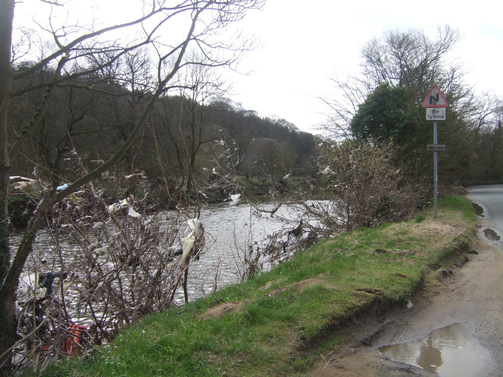
The Aire near Esholt, the river was at least 6 feet above
the banks when the floods came last December. |
 |
| Baildon, where town planning exists in three dimensions. |
 |
Baildon Bank, where a rough slope runs right into the town,
giving us a walkers a challenge to include it on our tour. |
 |
| Elevated walking is all about the views, looking towards Saltaire. |
 |
| Spare Lane, lots on undulations and moisture between Shipley Glen and Bingley. |
 |
| Bingley in the rain, one of the dampest arrivals so far. |
Next Up: Rest, and Social Drinking, and then I guess, April Means Serious Business.


No comments:
Post a Comment