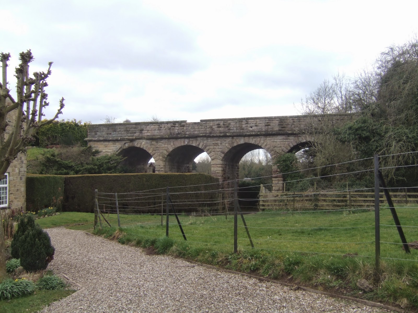
Resuming the trail on the 1848-1964 Church Fenton to Harrogate line, we start out from Tadcaster at 9.50am, and start of along the north bank of the Wharfe, so the first couple of miles of this railway walk will actually be river walking, as the extent formation to the south is fragmented with the river proving to be an insurmountable barrier. Beyond Mill Lane we can get one railway relic in though, the 1849 viaduct built for a projected line to York, which was never completed and hasn't had a proper use since, and then the trail strikes on along the riverbank until the grounds of Healaugh Manor get in the way and Wighill Lane has to be paced as far as the site of the abandoned village of Easdike. Return down to the riverside to skirt the edge of many fields, with the Wharfe at my left, sometimes below the crumbling banks and sometimes hidden behind the flood embankments and piles of accumulated driftwood, this couple of miles eventually past the sewage farm, bringing us back to the railway alignment, and the Thorpe Arch Viaduct, a sad looking mix of tone and steel, which must surely be crying out for redemption as every river crossing in these parts must be considered valuable. Rise onto the formation for a short while before slipping across the rough ground at the back of the Thorpe Arch Trading Estate, descending to the perimeter road to join the Wetherby Railway path, another triumph for Sustrans which we will accompany for the middle part of the day. Cyclepath and bridleway shadow the alignment to the site of Thorpe arch station, where the goods shed is still visible in the station house's garden, before descending to track level through a mile of stone lined cutting, know as Dave's Mile, dedicated to one of Sustran's most committed members, and it is a lovely bit of preservation work. Pass the keepers cottages at the Walton Road crossing, continuing along the alignment as it parallels the edge of Wetherby Racecourse, before passing under the A1 (M) and A168 and moving along Freemans Way and down a short ginnel before the alignment comes to an abrupt halt at the missing bridge on York Road.
A detour is necessary to the site of Wetherby's other station, but progress forward is blocked by redevelopment forcing a ways around via Deighton Road to meet the formation again, seeing the northern side of the Wetherby triangle again, before striking on as the track surface roughens slightly in the direction of Spofforth. We are soon gifted another excellent section of cutting, lined with greenery which puts a spring in the step for mile or so before the going get rather mundane, and the next village seems to feel a long way off, eventually met by abandoning the cycling surface and following the formation straight to Park Road and emerging by the Railway Inn. Redevelopment has claimed the station site, so the route through the village follows the A661 and Castle Street before detouring to get a close look at Spofforth Viaduct, rising over someone's back garden, with the alignment falling ridiculously close to Spofforth Castle. No way can be made onto the trackbed here, so a route around the impressive fortified manor house is made before striking out along the edges of Follifoot Lane and Haggs Road, crossing the formation at Haggs bridge but still having no right of access.so paces are made much further along the road, with the lack of railway being offset by this high ground offering views as far as Knaresborough parish church and the broad fringe of the North York Moors. Eventually a field walk leads us back to trackbed, where the Ruddings park estate has recently instituted a right of way along a heavily landscaped section of the formation, which is a most welcome development and can be followed to the bridleway under the A658, and a short step down here is the hidden gem of the line. Prospect tunnel is arrow straight and half a mile long, leading on to the bottom end of Crimple viaduct, and it has nothing to prevent you making your own way through below Follifoot ridge, but the darkness, poor footing and dampness have me putting this on off for a day when I am feeling a lot bolder. Instead, we rise to make our own way over the ridge with the jets on, for the last mile or so, to slip between the golf courses along Pannal Road to finish at the railway station at 3.50pm, scant minutes before my ride arrives.
5,000 Miles Cumulative Total: 1540 miles
2015 Cumulative Total: 137.8 miles
Up Country Total: 1413.6 miles
Solo Total: 1313 miles
 |
| Tadcaster Viaduct, built in 1849 and never officially used for anything. Its current status as a footpath is currently suspended due to land dispute. |
 |
| Healaugh Manor, interrupting my river walk but sure looking nice when the sun shines upon it. |
 |
| The Wharfe, Hello again to my old friend, we'll be seeing a lot more of you this year! |
 |
| Thorpe Arch Viaduct. Put this one on the list, after Castleford Viaduct, of river crossing that must be put back into public use. |
 |
| Thorpe Arch Goods Shed. The whole station seems to be intact, but most of it is hidden away behind a thick wall of conifers. |
 |
| Dave's Mile. The Y&NMR line's finest section of cutting on the whole route and Dave Hall should be proud to have his name attached to it. |
 |
| Walton Road crossing houses. It seems that almost everything required man power in the 19th century, automation has a lot to answer for. |
 |
| Wetherby Racecourse. No horse tracks on my first 3 years of walking, already gotten in two in the first 3 months of season 4. |
 |
| Wetherby Good shed, now a dance club and one of the town's hottest nite spots? |
 |
| Wetherby triangle, northern side. How could a town so blessed with railways end up with nothing? |
 |
| Wetherby Railway path, another grand section of cutting, so far un-named. |
 |
| Wetherby Railway path, the run in to Spofforth, a long time coming. |
 |
| Spofforth Viaduct, if you own the house adjacent, does this bridge become your responsibility? It certainly is a grand garden feature! |
 |
| Spofforth Castle. Original home of the Percy family, later to enter history as the long line of the Dukes of Northumberland. |
 |
| Haggs Bridge, with the trackbed inaccessible on both sides, so boo to golf courses and miserable land owners. |
 |
| Ruddings Park estate does deserve credit for allowing a right of way to be established on this section though, so kudos and credit due there. |
 |
| Prospect Tunnel, south portal. Dark, moist and inviting, but not somewhere I'll be venturing without galoshes and a much more powerful torch. |
 |
| Crimple Viaduct. The other major feature of the Y&NMR line remains in use, of course, and it's pretty enough to deserve another appearance here. |
No comments:
Post a Comment