No walking occurs on the weekend of 11-12th as there's a ice risk to deal with after the only significant snowfall of this persistently chilly winter coming at the end of the preceding week, and I value my ankles to much to be testing out some challenging going, and thus I can't be inspired to get going again until some actual sunshine arrives, to not be seen until the following Sunday, which means we are yet to get into a routine of Saturdays when starting from home, as we finally travel away from Morley to start from Cottingley station instead, as we need to make use for it now that notice for its formal closure has been posted. Get away ahead of 10.20pm, and pass over the footbridge to pass away from our local paths by taking the route across the Cottingley Hall estate, via the Dulverton Grove paths to pass north of the towers and over the Cottingley Drive orbital route to descend through Cottingley Cemetery as a path exists to take us past the crematorium and chapels before we dropped out at the point where the A6110 Ring Road Beeston and A643 entangle themselves, where we cross by the builders yard and cement plant to follow the latter as it leads up to, and under, the railway line to reveal the Planet Ice rink, which has finally opened after an extremely prolonged construction. We'll move toward the city, and our planned targets as we join Bobby Collins Way as it leads though the lots of the Elland Road Park & Ride, where the Covid vaccination centre loitered for most of 2021-2, taking us round the side of Leeds United's ground that regular traffic doesn't normally see, before we split under the M621 to the Lowfields industrial estate, and move with the footpath down to Junction 2 where all sorts of heavy engineering work is going on the remodel the traffic island, which looks certain to be ongoing for a while, before we shadow the A643 once more as it heads off to form the Leeds inner loop road.
 |
| Dulverton Grove, Cottingley Hall estate. |
 |
| Cottingley Cemetery. |
 |
| Elland Road stadium, Bobby Collins Way. |
 |
| Extensive Roadworks ongoing, M621 Junction 2. |
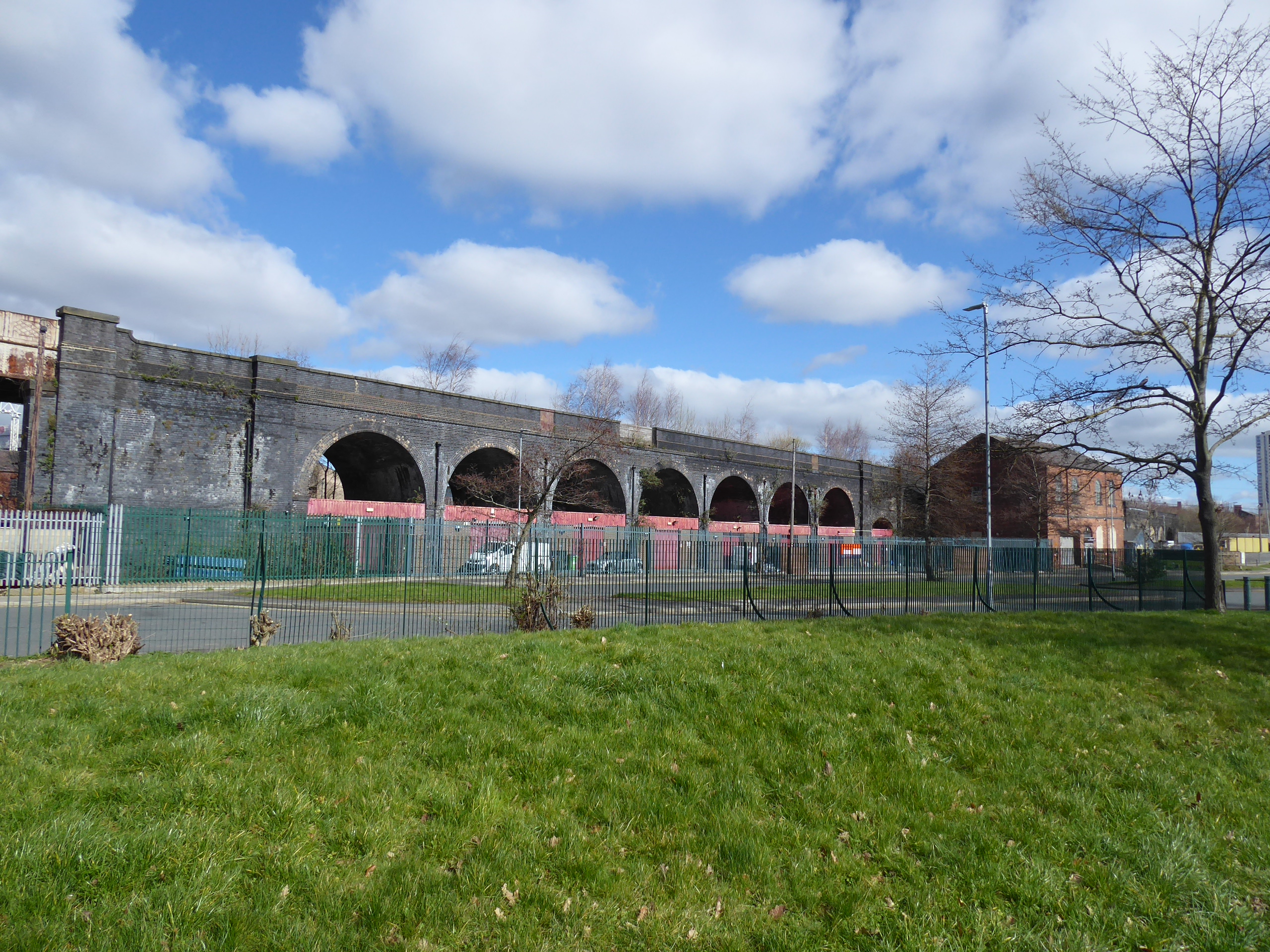
Having switched sides by the Matthew Murray school site, we can approach the first target of the day, which is Farnley (or Holbeck) viaduct, on the L&NWR's alternate line into the city which is still disused after 35 years of inactivity, but still poses an impressive structure in blue brick as it reaches into the city, looking like a formidable landscape barrier but with the industrial city actually dictating its original placement, to be regarded up close as we return to the path we saw it from a decade(!) ago as it shadows the Domestic Road flyover and passes over the culverted Hol Beck on its way east. Passing over Domestic Street, and north of urban Holbeck, its arches and spans reach towards the city from Balm Place to Czar Street, with the industrial units enduring below, along to the site of Holbeck MPD on Bridge Street, where we'll switch sides to walk along the footpath that leads tightly under the former MR line, and the suddenly curving viaduct by an impressively sked high arch which leads us to the side of Bath Road where it starts to describe an S-curve above the cluster of motor garages with their surprising selection of vintage cars. From Water Lane we can get a fresh perspective on the viaduct by walking down the dead end of Silver Street as it leads to the Midland Mills site but can't sneak north by following the rough and overgrown path by the Chow Down enclosure, and instead we have to follow the beck channel as it leads us to the Holbeck Urban Village development by the Cross Keys and Midnight Bell taverns, and onto Globe Road to double back between the unappealing developments of Globe Point and Tower Works to meet the final ironwork span as it passes overhead, just shy of the west end of Leeds City station.
 |
| Farnley Viaduct, from the Inner Loop Road. |
 |
| Farmley Viaduct, from Domestic Street. |
 |
| Farnley Viaduct from Czar Street. |
 |
| The Bridge Road - Bath Road passage. |
 |
| The Silver Street crossing. |
 |
| Farnley Viaduct. from Globe Road. |
We can still hope it might have a future as an elevated and linear urban garden, for just a short ways away beyond Whitehall Road, we have such a development emerging atop the Monk Bridge viaduct, on the approach to the lost Leeds Central station, which can be approached on its south side as the Latitude Towers development continues apace, to see that its presence still looms despite the buildings continuing to grow around it, but the real interest comes from seeing what's going on the trackbed level, now officially accessible once a jaunt has been made across the canal and the river Aire. From the Wellington Place side we can rise with the newly constructed steps and lift to reach the railway alignment level legally for the first time since closure in 1967, to find that shrubbery gardens have been laid out on the spans across the river and canal, providing us with a new vantage point to regard the city, as well an an access path to the five towers of the Monk Bridge development, which needs to be followed despite the fact of it apparently entering a building site, with scaffold shrouds and security fencing everywhere, taking us beyond three of the residential towers that are still developing around it. Ahead of Tower 3, the viaduct splits, with the branch alignment down to the NER and MR lines leading into the tower block, and the main structure towards the GNR lines having more garden created upon it, illustrated by the vast amounts of bagged topsoil abounding, while below the junction a covered plaza is developing to create commercial enclave under the arches, with multiple access points of steps and lifts installed to render this south bank side accessible as the development expands in the future, altogether a fascinating work in progress that we can look forward to returning to, I'm certain.
 |
| Monk Bridge Viaduct from Latitude Park. |
 |
| Monk Bridge Viaduct from Latitude Park, again. |
 |
| Monk Bridge Viaduct from Wellington Place. |
 |
| The Monk Bridge Gardens, looking Southwest. |
 |
| The Junction Gardens, Monk Bridge. |
 |
| The Monk Bridge Gardens, looking Northeast. |
It's a spot to loiter for a light lunch of sports before we descend and return to the paths, with the Leeds and Liverpool towpath being the most direct route to the final themed target of the day, not an original choice to make by any means, having paced down here as recently as last June, but it is a walk I like a lot, from the railway workshops at St Ann Ings lock, with the tower blocks looming around, up past Castleton Mills to the residential enclave between Oddings Lock and Spring Gardens Lock and, on along the embankment above the River Aire to meet Kirkstall Viaduct. It's the only active one of Leeds's trio, and possibly the least regarded of them too, and while having done hundred of journeys over it on the Harrogate line in my locally resident days, this might be only the second time that I've walked below its quarter mile length, descending with Viaduct Road from its passage over the Aire, down past the council grit depot to the A65 Kirkstall Road crossing that we've seen a whole lot, and up through the open parkland behind the still vacant Rising Sun inn and down from St Matthias's church, still looking in fine fettle and still displaying its 1849 vintage well. A passage through the Wolseley Road enclave leads us towards Burley Road, and then into Burley Park itself, our regular stomping ground in the 1999-2007 window, where we rise up the eastern perimeter alongside the railway, past the still surprising-in-this-landscape apartment developments, the woodyard and the redeemed St Margaret's church, now know as Left Bank Leeds, as we also skirt the playground and bowling greens before emerging out to Park View Road and then follow Park View Avenue as it leads us through the semis in a district of terraces, around to Ashville Road, where Burley Park station, our finish line lies below.
 |
| Monk Bridge Viaduct, on the Leeds & Liverpool Canal. |
 |
| Kirkstall Viaduct, on the Leeds & Liverpool Canal. |
 |
| Kirkstall Viaduct, from Viaduct Road. |
 |
| Kirkstall Viaduct, from the Kirkstall Road playground. |
 |
| Burley Park, the Park. |
 |
| Burley Park, the Station. |
For me, it's still the third most used of all the West Yorkshire stations, but only making its third appearance in my walking career, where this relatively brief urban walk ends, just after 1.15pm, with me really feeling like I'm done for the day, despite the sunshine and warmth, after only three hours out, and we're thankfully not too far ahead of the next ride into Leeds, seeing as the Harrogate line doesn't have a trash-fire Sunday service, because busing it home will have to be the path from there, once the days last footfalls are made as we quest around the city centre, looking for new socks and a cheap (and much needed) loaf of bread...
5,000 Miles Cumulative Total: 5948.1 miles
2023 Total: 25.9 miles
Up Country Total: 5,467.4 miles
Solo Total: 5605.5 miles
5,000 in my 40s Total: 4537.9 miles
Next Up: WOO!!! SPRING BREAK!!! (not that I actually have a plan for it...)


No comments:
Post a Comment