13.4 miles, via Northorpe, Little London City, Kitson Hill, Lower Row, Cooper Bridge, Bradley,
Bradley Bar, Fixby, Round Hill Bottom, Badger Hill, Fixby Ridge, Ainley Top, Lindley Moor,
Mount, Hirst Wood, Scapegoat Hill, Clough Head, and Crimble Clough.
It's been in the background since my walking season opened out, but this week the Wuhan Covid-19 Outbreak has officially spread enough to be classified as a global pandemic, and that means that enforced social distancing and self-isolation are a near certainty in the coming weeks, and the probable restriction of travel means that a severe crimp on my walking plans as usage of public transport for leisure, and potentially exposing myself and others to the risks of the Coronavirus, will be an absolute no-no for a while. There's no formal restrictions in place yet, and working in the NHS means that I'm not likely to be able to be kept out of work unless I'm felled by illness, and on the edge of the walking year really getting going, there's a significant chance that all of Spring will be lost as the country does what it can to restrict movement and contain the spread of this virus, so we'd better put down some miles on the trail before the opportunity gets taken away, pulling up a left over trip from last year to take us over the hills between Calder and Colne. So away from Ravensthorpe at 10.15am, leaving the station for the fourth time, having yet to end a walk there, but pressing north for the first time, and finding it frustrating that it's hard to get a good look at the L&YR vintage goods shed, as it's hidden away just a bit too deeply in its industrial estate, so we head on over the Calder via the Truss bridge, noting that the river looks placid below, and that there is access to the north bank path that I failed to see in 2012, before press up towards the A644 between the mass of riverside industry and long runs of terraces. Cross over the Huddersfield Road and get tied up with the paths of the roads around the traffic islands that I believe simplify access to the retail park across the way, on the site of the old gasworks just along from St Saviour's church and the old Co-operative store, where we take a right turn onto North Road, which goes further to reveal the extent of Ravensthorpe as we pass its terraced face and the Diamond Wood school, noting that both churches and pubs along the way have been re-purposed to suit the needs of the local population. Pass into Northorpe, if it really is a place, as the lane divides, with both portions meeting the site of the station on the former L&YR Mirfield - Low Moor lines, of which some embankment and retaining walls endure, making this corner of the village feel over-served in the pre-suburban past, as it sits just a short way south of the equally lost station on the L&NWR Heaton Lodge - Wortley lines, which we touch base with again, along with The Plough inn as we start to graze the upper edge of Mirfield proper, as Shillbank Lane passes above the suburban splurge over the railway alignment to meet Flash Lane, where proud terraces face the view down to St Mary's church.
 |
| The Calder bridge, Ravensthorpe. |
 |
| St Saviour's church, and the Old Co-op, Ravensthorpe. |
 |
| The remains of Northorpe L&YR station. |
Land on Dunbottle Lane, just up from the Dusty Miller inn, and as we progress on westwards, it feels like we've settled onto the local pub crawl route, as the rising lane takes us past the Old Colonial and the local cricket club before we land on the Lee Green road, where some of rural character remains in the suburban growth and which the old OS map rather over-names as Little London City, where we also encounter the Shoulder of Mutton, and the Savile Arms on the Old Bank Road corner, crossing the last path that we burned across the town. Kitson Hill Road leads us above the council estate that has filled out a large portion of higher Mirfield, as we move to pass the extensive site of the Mirfield Free Grammar school, with the playing fields opening out opposite to give us a perspective over the middle Calder valley to the south, ahead of the decling road that gives us a view towards the mist shrouded Colne valley and the wooded banks of the upper Calder as we descend, before settling into a urban-rural landscape once more. At the corner with Stocks Bank Road, we meet the buildings of the Community of the Resurrection, the home of an Anglo-Catholic order, with a Romanesque church that stands prominently over the valley, certainly more imposing than the parish church of Battyeford, Christ Church, which sits next door, low rise and very mid-20th century modern, ahead of the limits of the suburban spread of greater Mirfield, along the lane as it declines to meet the side of the A62, opposite the Nun Brook Farm complex and up from the Three Nuns inn. The paths seems to converge on this corner when on this north side of the Calder, and this will probably be my fourth trip along these pavements as we move to tangle up with the A644 and the route of the Kirklees Way as we come up to the traffic island by the Dumb Steeple, the roadside monument that was a gathering point for the Luddite uprising of 1812, ahead of our shift southwards to pass under the railway, past the sewage works and on to the passage over the Calder & Hebble Navigation channel and the river Calder at Cooper Bridge, ending the day's preamble before we settle into walking the limits of greater Huddersfield.
 |
| St Mary's church and the Dust Miller inn, Mirfield. |
 |
| The Mirfield Free Grammar school. |
 |
| The College of the Resurrection, Mirfield. |
 |
| The Dumb Steeple, Cooper Bridge. |
Leaving the Kirklees Way route, of which we will see much more before today is out, we rise with the side of the A62 to the White Cross inn junction, where we split onto the A6107 Bradley Road, which feels like a relatively modern bypass around Huddersfield, but has actually been on the ground for a very long time, climbing to the north of the town, and onto the Colne-Calder ridge, ensuring plenty of ascending to come as we head up between the council estates and suburban spread of Bradley, while keeping an eye out for the rural residue of history, which we find around Bradley Grange farm. Keep gaining height among the gradually narrowing suburbia, sneaking a view over to Castle Hill before we settle firmly onto the northern Calder side of the ridge, soon coming up on the ancient and enduring Screamer Wood on the southern side of the lane, around which every non arboreal plot has been claimed by residential development, the High Park pub & grill, or the Pennine Business Park, ahead of our third point of contact with the Kirklees Way, as it passes over on its way to the perimeter of Bradley Park Golf course. There's some sunshine to briefly enjoy up here as we switch sides on the road, taking us past the All Saint's RC college, and the run of suburban semis that have been perched on a high knoll for the best possible views to the north, but gloom has returned as we come up to Villa Farm at the Bradley Bar island with the A641, where a roadside marker indicates we are on the Dewsbury & Elland road, indicating to me that this lane probably predates the riverside route much further down the valley. We rise on with Fixby Road as we sit at Huddersfield's smart suburban perimeter, with the houses on the north side looking like the kind that you could never hope to afford, while our side to the south takes on a wilder aspect as we pass the high edge of Upper Fell Greave woods, before coming upon Fixby's parish church, St Francis (in the Modern Style, again), opposite the entrance to Huddersfield's crematorium, and just along from another contact with the Kirklees Way, as it dives away from the road and into the trees to the south.
 |
| Ascending the A6107, Bradley Road. |
 |
| Screamer Wood. |
 |
| Villa farm, Bradley Bar. |
 |
| Upper Fell Greave wood, Fixby Road. |
We'll only share its path along the pavement as it passes the Nisa Local, before Clough Lane peels away around the edge of Fixby Green, where the daffodils and crocuses are almost ready to bloom with the colour of spring, with the A6107 beyond ending its long ascent, slipping out of this outer edge of Huddersfield past the Four Sons inn and then diving down under the M62, landing us briefly on the outer edge of Calderdale at Round Hill Bottom, by the cricket field with the large wooded knoll above it, which is super obvious when passing east on the Motorway. This leads us to the end of this trunk road at the top end of Rastrick, the neighbour up the hill to the south of Brighouse, passing the fire station, the pebble-dashed council house and the terrace with the over large eaves as we hit the Badger Hill crossroads by the Sun Inn, perched high over the Calder valley, where we split onto the rising A643 New Hey Road (Morley's local A-road again), as it heads uphill to the M62 again, while also illustrating that even at this altitude at the valley, a desirable residential development or two can be found. Pass under the motorway and settle onto a rough footway that rises below the looming wooded bank of Fixby Ridge, the hillside on which both the waterworks and the major microwave tower for Huddersfield both stand, neither of which can be spied for an age, but as the road rises we eventually come up higher than the M62 and get a reveal of the Calderdale view over Elland and towards Halifax, with sunshine passing over to illuminate it as we rise. The lattice tower on the ridge eventually rises prominently, as should be hoped, standing sentinel over the fine view to the north, ahead of the road cresting by the main gates to the parkland of Fixby Hall, at quite a remove from the golf course that now occupies most of it, and get a reveal over the northern portion of Huddersfield as the altitude of the ridge drops away, revealing the Colne and Holme valleys' horizon beyond the many rooftops, while our route splits us off to approach the village of Ainley Top, and outermost suburban settlement if there were ever one, enduring above the tangle of roads on this high hillside.
 |
| Fixby Green. |
 |
| The Sun Inn, Badger Hill, Rastrick. |
 |
| The Calderdale view over Elland, from Fixby Ridge. |
 |
| Fixby Hall's gates, and the Fixby Ridge microwave tower. |
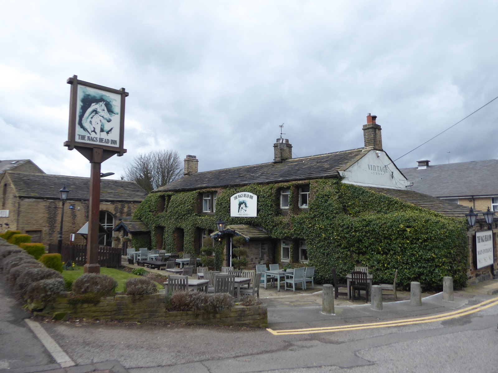
It's all very suburban to the east of the deep cut made by the Halifax Road, with the Nag's Head inn and its associated Premier Inn at the heart by the junction of the old Grimescar Road, where we'll pause for a watering ahead of passing over the A629 to find council houses and the Clarion Court hotel located in the loop formed by the A643 and the Blackley New Road, gouging its way through the landscape down to junction 24 on the M62, where we get back onto the main route with the rising Lindley Moor Road, hitting another grand elevation into the fields that actually rises higher than Fixby Ridge. The M62 and the view towards Halifax will keep us company to the ridge top by the road contractors depot, and beyond lies a landscape that has shifted somewhat since the Kirklees Way brought me this way in 2014, with all the plots beyond having been filled out by residential and commercial use, largely as Huddersfield wants for large level areas for redevelopment, and the old field path that we traced back then now being tarmacked, and the nearby Wappy Spring inn no longer really being a country inn. The A643 gradually draws right up to the side of the motorway, with only a bank of trees keeping us away from it, as we meet the older edge of suburban Huddersfield once more, at a limit that it literally cannot exceed without slipping into the Calder Valley, and we'll not quite get to the very end of this route as it concludes at the nearby Outlane roundabout, as our route over to the Colne valley needs us to take a turn onto Woodlands Road through the suburb of Mount, which isn't nearly as 1970s suburban as you might expect. Away from the watershed and beyond Moorlands School, we find a run of terrace houses by the Mount Methodist church, next to the dual carriageway of the A640 New Hey Road, which a subway tunnel passes beneath, traversed as the only rain shower of the day pelts down, dropping us out on Ray Gate at the top of the old roads that passed up and out of the Colne valley from Longwood, among some distinctly rural flavour by the Hirst farms, where we make a seventh(!) point of contact for the day with the Kirklees Way.
 |
| The Nags Head inn, Ainley Top. |
 |
| Urbanisation claims the fields of Lindley Moor. |
 |
| The suburban face of Mount, on Moorlands Road. |
 |
| The Rural face of Mount, at the top of Longwood Clough. |
Having paced metaled surfaces for trail so far, we're going to actually off road for a while, steeply descending the grassy and muddy track of Shaw Lane, where we can look south-east down Longwood clough towards its reservoirs, to bottom out in Hirst Wood, where we detach from the Kirklees way route again, heading upstream with Longwood Brood below the tree cover to the crossing point, where the water noisily cascades into the bottom of the valley and a track of setts twists its way sharply uphill to the south-west. The track rises to become broken tarmac and then concrete, passing up the side of part of Outlane Golf course, with the steep climb up to Shaw farm proving an excellent descent for the mountain bikers that come the other way, while run-off water also pours onto this track, with the local sheep looking on quizzically as we gradually rise to the altitude of the Calder-Colne watershed, where more afternoon sunshine reveals the evolving view over toward Halifax as we rise on with the roughened lane up to Whin Gate farm. Hairpin back on the track that rises above it, hitting moorland altitude as we go, with the sunshine bathing the view over Calderdale beyond the M62 on the ridge, finding it odd that the high climb isn't actually over the watershed, while also peering out to the west and wondering if we'll actually have a chance to explore that landscape before we crest up towards the moor top, seeing views over Huddersfield and sight lines to much further afield emerging to the east as New Lane directs us over towards Scapegoat Hill. It's cold at 330m up, with the wind from the south-west bites in hard, bringing ominous skies with it, as we progress along the dirt track to the south, gaining a hard surface and touching the Kirklees Way route for the last time as we cross over Nettleton Hill road, downwind form Longwood Common and the Pennine Manor hotel, and below the shadow of the bulk of the village's imposing Baptist church as we land on the High Street of Scapegoat Hill, a farming settlement at altitude that has retained all of its rural appeal whilst also becoming the absolute remotest and most elevated of all of Huddersfield's suburbs.
 |
| Descending Shaw Lane to Longwood Brook. |
 |
| Ascending Shaw Lane to Shaw Farm. |
 |
| The view over the watershed to Halifax and Calderdale. |
 |
| New Lane leading into the back of Scapegoat Hill. |
High Street swings around its western edge, with many cottages sitting right on the cusp of its promontory, and we then decline around the village with Taylor Lane, below the village burial ground and the ranks of desirable residences that have arrived here, high above the Colne Valley, a fine place to live if you don't mind the remoteness, the challenging and steep roads and the bus service that takes a circuitous route to get up here, our location well-revealed as the sight lines open out below to give us a look down towards Bolster Moor and Golcar, right at Huddersfield's western edge. Meet the wider path of Pike Law road below the town, which never quite gives us that view of how the village appears to be stacked up upon itself, and teasing views over the Colne Valley to Meltham Moor as it leads us away to the top of Slaithwaite Gate, keeping the way down as well concealed as possible before we start out descent properly, as we land in the hamlet of Clough Head, with the masts on Pole Moor standing prominently above, passing the old Dog & Partridge inn site before the road dives down into Crimble Clough, above which the village school stands, with a cliff forming it's own climbing wall below it. Our destination sits far below here, not to far as the crow flies but well hidden by trees and the folds of the landscape, with steps having to be taken carefully against the ascending traffic on the narrow lane as we come down to the hamlet-let midway up, where the houses seem just a bit to smart to be hanging on the valley side, which is where we meet the Colne Valley Circular route and pass within it, revealing a good view up and down this side valley and making me glad that this isn't a route that I am ascending, as was originally planned. Heading down to the marked kink at Window End, the road narrows sufficiently to cause a snarl up when vehicles have to pass each other, and there are llama in the field to watch the shenanigans too, below which we run into the bank of trees that sits above the outermost reach of Slaithwaite, with terraces reaching up the valley in long fingers, and the stream that forms the valley arrives in a deep channel along the front of Brook Side and below Brook Terrace. Bottom out at the bottom of Crimble Bank, by the Swan Inn and then it's rise to get to the actual finish line, rising back up to the level of the railway and spotting the new, and un-liveried, TPE Nova units running over Slaithwaite viaduct before we swing around the well placed terraces above the valley and the town to land at the railway station at 3.15pm, with the best of the day's weather in our wake, while really getting the feeling that my walking exploits might soon be brought to a sudden halt, with the planned jump-offs from here to fill out the Spring between Colne and Calder look distinctly doubtful.
 |
| Scapegoat Hill raked above it cemetery. |
 |
| Slaithwaite gate leading to Clough Head. |
 |
| Descending Crimble Clough. |
 |
| Slaithwaite arrives in the valley. |
 |
| Brand New Trains on Slaithwaite viaduct. |
5,000 Miles Cumulative Total: 4362.1 miles
2020 Total: 95.6 miles
Up Country Total: 3899.1 miles
Solo Total: 4047.9 miles
5,000 in my 40s Total: 2955.9 miles
Next Up: 10 Days Not In Work, and I've no idea what I'm going to do with them...


No comments:
Post a Comment