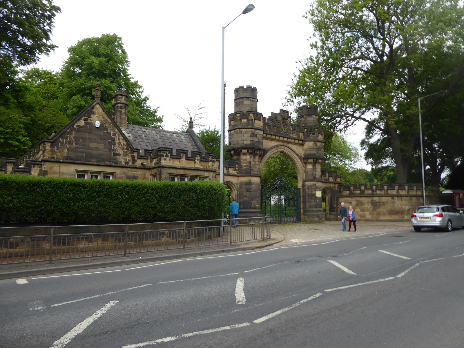
Return Up Country with 40% of the Leicestershire Round off the slate already, and a slightly less downbeat assessment about the progression of the onset of Parkinson's disease on My Dad, but also bring back a right foot that has suffered unprecedented blistering, and a calf muscle that suffered quite a strain in my attempts to not put pressure on the foot below it, but after three days of relative rest away from the trail, I'm ready to go again once Bank Holiday Monday morning rolls around. So slap on the plasters and the support bandage and get used to the new railway timetable as I start out late-ish for the latter stages of my Spring trails over the hills between the Aire and Wharfe, as this last week has had too many hours walked in the cool and overcast mornings before the day takes a turn for the warmer, so we depart from Keighley station at just before 10.35am, with most of the day's gloomy opening having already passed as we depart for the day on a north-westward track. Pause to admire the MR vintage tilework at the station before heading out and down Bradford Road to cross to Cavendish Street, home to the long shopping parade with the glass canopy down its full length, home to stores that don't quite deserve their setting and altogether a frontage that wouldn't look out of place in Harrogate, and also wonder if the styling of the car park of the Airedale centre is a cheap version of that at the Victoria Gate centre in Leeds, or if it might be the other way around? Meet the Cenotaph gardens and the town's municipal buildings, where a false owl lives in the cupola above the public library, before turning onto Skipton Road and passing the pair of cinemas, the contemporary Picture house and the former Odeon, home to Gala Bingo, before heading out into Keighley's Victorian villa and terrace district, opposite the castellated entrance to Cliffe Castle park and on to the B6265. Instead of following Skipton Road exactly, we'll wander a little to get a bit more landscape interest along the way, dropping down to get some improved views up to the looming Rivock Edge across the valley from the terraces along Arctic Street, and by heading up Green Head Road to pass Keighley University Academy and to get some contextual views up the Aire from the village suburb of High Utley, where St Mark's church is its best feature. Off the main roads we descend to meet Low Utley, with an ancient farm and cottage cluster at its heart, with suburban growth all around, with the cobbled Keelham Lane leading on over the railway, the A629 and behind the town cemetery, and on down to the bottom of the river valley as the road leads us over the Aire via the most obscure of bridges and on into Holden Park, nowadays home to Keighley golf club, where the golfers teeing off pose the most immediate risk to the walker.
 |
| Cavendish Street and its long Canopy. |
 |
| Cliffe Castle park gatehouse. |
 |
| St Mark's, High Utley. |
 |
| Keelham Lane, Low Utley. |
 |
| Holden Park and Keighley Golf Club. |
Beyond the former farm at the centre of the course, the path leads straight across the fairways for more golfer avoidance action before we run into the woods below the Leeds & Liverpool canal, where you might expect the bridleway to join the towpath, but it remains separate to pass through the rough ground between canal and golf course, through a sea of giant rhubarb and sprouting bracken before finding a more path-like path by the perimeter wall that leads us below the rising Lodge Hill. This rolls us out at Low Holden farm, and on to Low Lane, where the views up to the edge of Rombalds Moor are grand, from White Crag around to Spring Crag Wood, and this quite lane seems rather busy with human traffic, as it seems that the towpath has been closed through Silsden for necessary rebuilding work, which I could have told you about the need for in 2012, before we meet the route of the Bradford Millennium Way at Howden House. Carry on towards Hainsworth Road, and take in the views to south sided of the Aire valley as we go, from Hollins Bank and around to Earl Crag, as we move on to the edge of Silsden, having seen most of these leafy lanes before but not in such nice weather as today's, passing the civil engineers' sit for the canal work before we meet the suburban closes at the canal side and industrial park below. Altogether this quarter is not the type of suburbia that I enjoy all that much, but it's the route that I have to take to meet the passage below the canal aqueduct that leads over the road and the adjacent beck, where the immediate environs have a bit more vintage to them, and the residential complex at Waterloo Mills is altogether more appealing to my tastes. St John's Street leads us up past the terrace ends of the older town and up to the weir on Silsden Beck where the ducks bask and bathe, before we cross over and head up the beckside on a fresh path through the town centre, behind the Methodist church and onto Wesley Place, home to the RC church of Our Lady of Mount Carmel and into the town's memorial garden, where a sole bench can provide shade for lunchtime, which has already arrived. Then onwards, over Kirkgate in the shadow of St James's church, and on to Briggate, which really looks like the ancient heart of the town, leading us across Bridge Street and past the exciting retail opportunity in the old butchers shop before we join Bradley Road to start our ascent out of the town and onwards to our target for the day, some 270m further up the hill at Skipton Moor. Before we've gotten too far out though, we need to pause to admire Silsden Old Hall and its neighbouring farm, an admirable 17th century edifice with three gable ends that might well be a tourist attraction in a different location, almost feeling a bit hidden in plain sight as suburbia has spread around it and up the hillside on the north bank of the Aire.
 |
| The old bridleway below Lodge Hill between the Holden farms. |
 |
| Looking to White Crag and Spring Close Wood. |
 |
| Looking up the Aire to Earl Crag and beyond. |
 |
| The Hainsworth Road aqueduct, Silsden. |
 |
| Silsden Old Hall. |
Greenness soon arrives at the roadside, as trees contain the road below the suburban gardens above, as a Calderdale-esque ascent leads us uphill to the vantage point by the Raikes residential home of the Elderly sits, where the steepness of the roads ensures your relatives are unlikely to be running away with any ease, rising on onto open countryside to get the first of many views back to the western profile of Rombalds Moor and back down into the haze-filled cleft of the Aire Valley. Bradley Road rises on, not offering many views beside these initial two, before we split off onto Horn Lane at 100m into our climb and finally start to get an evolving view over into Wharfedale as Beamsley Beacon rises above Cringles and its mysterious chimney, and sneaking a brief view of the sharp edge of Earl Crag before we elevate onward past Upper Hayhills and Dixon Green farms, and look on again to see Woofa Bank and Draughton moor rising to the north east. Passing Low Lane, it's worth noting again that we are running close on the Millennium Way path again, but from a field or two further up the hill there's not much to remind me of being out here before, so the feeling of being in a new landscape endures as we pass on uphill, with the pastures and campsite of Lower Heights farm behind us and the shape of Horn House focusing our attention forwards as we approach Heights Lane. Switch a junction or two to hit Kiln Hill Lane, passing on a shady rise before we can finally level out the track at about 280m up, finally getting a hint of the crest of Skipton Moor ahead, as the lane brings us on past High Bracken Hill farm, where the local dairy herd gets curious and mobile behind their wall, and the views across to our last path up this way evolve pleasingly, though there's no view down into Airedale still as the rise of Cocklick Hill (no sniggering at the back, thank you) proves to be a grassy impediment. Meet Green Lane and the bulk of Skipton Moor starts to form the horizon to the north, and as we pace up to Lower House farm (aka Peel's Laithe), the view down to the Aire valley opens out again, drawing the eye down towards Low Bradley and over to the upland which Pinhaw Beacon sits atop, off to the west, as we continue onto the driveway to Moorgate farm, which hides in a dip in the landscape, but remains obvious because of the wind turbine on the cresting fields that forms its large front lawn. The grazing sheep here are certainly curious to have a visitor on their plot, and beyond the farm we have a rise on through fields which are home to the local diary herd, and it doesn't look like much of a fun ascent to get up to the moorland altitudes whilst avoiding the cows but meeting another pair of walkers coming down the path from the moor suggests that these cattle might be appreciably docile.
 |
| Bradley Road ascends out of Airedale. |
 |
| The Western face of Rombalds Moor. |
 |
| North East to Draughton Moor, Woofa Bank and Beamsley Beacon. |
 |
| High Bracken Hill farm, with cows and the looming moor. |
 |
| Moorgate Farm, with Skipton Moor beyond. |
It turns out that these cows will not be moved from their ruminating as the afternoon sun beats down, and all the curious ones aren't in the same field as us as we hit the rise again, gaining a further 30m of altitude in a single field to cross over the 300m barrier and onto moorland altitude, and the periphery of High Bradley Moor, and the view back expands before we press on, looking down towards Cononley and on to Gib, that other hillside with an inexplicable chimney atop it. Hit the moorland grasses and rise to cross the next plot, with our next target of Millstone Hill rising beyond, though we have some marshiness to negotiate before we can rise on to this subsidiary hill, which rises above 335m and is littered with loose chunks of gritstone that resisted attempts to be removed for industrial use, a fine viewpoint to look down to Airedale before we strike on to the moor top. There's another stretch of bogginess to descent to and negotiate as we pass over the headwaters of Black Sike before we hit firmer ground on the rise to Standard Crag, the sharp southern edge of the highest moorland at 350m up, where the cotton grass is in full bloom already and the view beyond the moor reveals the path's crest and the view down to Skipton in the valley below. Another good secondary summit to pause upon, to look to the nearby Flasby Fell and Barden Moor, and to the distant Forest of Bowland, and to Kirkby Fell and Rye Loaf Hill, but the interest point is to the north east and much closer as the summit wrinkles of the moor rise a half mile distant and offer a clear path down and up that isn't advertised on any map but is plain and obvious on the ground. So back along the crag edge and descend into another sea of burgeoning cotton grass, getting a view over into Wharfedale over the level and moist moorland plateau to the east before meeting sheep in the sheltered pasture between the moorland crests and following them as they attempt to retreat along the path that leads up to the summit ridge, where cairns and trig point stand prominently. To the eastern end we go first, to the cairns that are taller and wider than I am, with the Wharfedale moors as a backdrop, revealing a perspective of this moor that you just cannot get from using the old turnpike path along the northern edge, and then it's on to the middle of the ridge, neatly framed by the 350m ridges on the north and south sides to attain the summit at 373m at the trig point. A fine panorama over Barden Moor can be had here, though Embsay Crag is completely hidden by its elevated backdrop and the eye is drawn over the western edge from Crookrise Crag up to Cracoe Obelisk, and despite expectation sit looks like I've not got the top to myself as two other walking men are greeted before I move down to the guide cairn to enjoy the view down over Skipton.
 |
| Airedale view to Bradley, Cononley and Gib (& company). |
 |
| Millstone Hill, and Black Sike. |
 |
| The Skipton Moor summit crests, from Standard Crag. |
 |
| The eastern summit cairns, with the Wharfedale moors, and sheep. |
 |
| The Skipton Moor summit trig, western cairn, and Standard Crag. |
Note the distant Pendle and Boulsworth Hills before needing to pick out the path down again, not too difficult to find down from the sharp edge to get down to the transverse path we came up on, rapidly losing 70m of altitude as we come down from the so-called Vicar's Allotment, finding that the highest ridge look nowhere near as prominent as we look back uphill and find some frustration that the path over the access land that I had intended to walk down is blocked by a moorland wall taller than myself. So the way down to Cawder will have to be a slightly less direct route, hanging by a wall and running close to the path down Jenny Gill which we have already seen, focusing attention over the town and to the hills beyond as we pass down from moorland altitude and meet the grassy track that runs above the Greatwood estate and the cistern reservoir above the town, sharing the best views over the crags with the local sheep and their lambs. The way down leads us to a field behind Great Wood plantation, which I'd misidentified as the way to go descend, as the right of way starts to lead us away from the town rather counter-intuitively, around a blind rise to meet the woods that cling rather loosely to the edge of Cawder Gill, which leads us into the grounds of Cawder Hall and the high fields of Airedale where hay making seems to be the business of late May. Look back to Gib and Earl Crag before we meet the hard surface of Cawder Lane which leads past the desirable developments of High Snaygill and Horse Close farms, in the shadow of Horse Close hill before we meet the hidden footpath that leads back towards to the town, down into the council estate of houses in pale stone and stucco that has named all of its roads after local hillsides. Cut a slightly incongruous figure as I pass along Sharphaw Avenue and Roughaw Road, before crossing over the Grassington branch (former-ish) and meet what feels like Skipton proper beyond, as Firth Street swing around the extensive site of the former and partially redeveloped mills and on down among the long frontages and terrace ends that face it before switching off Sackville Street and crossing the Leeds & Liverpool canal again to enter New Town. Pass more terrace ends and Brindley Mill as Lower Union Street leads us to Keighley Road, and Christ Church, the major Victorian companion to the Medieval Parish Church, built as the town grew in the 19th century, walked around at a slight remove before we cross Craven Street, betwixt the Railway and the Craven Inns, and meet the Black Walk, leading us between Tesco and Morrisons to our destination. Or between the former railway goods yard and the former cattle market if you'd prefer, giving us a mostly new perspective over Skipton before the excursion runs out at 3.35pm, concluding another hot and slow day (on mostly one leg) at the end of this very satisfying and productive Spring break, let's hope the looming High Season proves to be so fruitful and rewarding!
 |
| Enjoying the view over Skipton with the sheep. |
 |
| Cawder Gill 'woods'. |
 |
| Cawder Lane and the edge of Bucolic Airedale. |
 |
| Firth Street Terrace, Skipton. |
 |
| Christ Church, Skipton 'New Town'. |
5
,000 Miles Cumulative Total: 3306.7 miles
2018 Total: 194.2 miles
Up Country Total: 2976.5 miles
Solo Total: 3027.9 miles
Next Up: Walking back into Wharfedale and to the jump-off point for the High Season!


No comments:
Post a Comment