16.1 miles, via Frog Island, Abbey, Stocking Farm, Leicester North, Mowmacre Hill,
Thurcaston, Rothley, Swithland, Woodhouse, Quorn, Woodthorpe, & Charnwood Water.
No Late Summer Jollies away this year, as we are instead Down Country to celebrate My Parents' Golden Wedding Anniversary, and after the exertions of the last walking weekend and a frankly harsh four day week, I could be forgiven for not wanting to walk at all when my nine day break comes around, but that would be a foolish choice to make, with 3,000 miles on the immediate horizon, and so we fit in one day to wander at the mid point of the week, tidily accommodated amongst everything else that's going on. I do seem to have spent a lot of my blogging life lamenting the industry and the railways that we have lost over the last half century and more, and so to make a change, we will today take a more positive approach and go in search of the Great Central Railway, both former and preserved, between Leicester and Loughborough, because as of this very week, exciting developments are afoot, and probably demand my immediate attention while I have another landmark to attain in my walking career. To the Town then, bussing it out to give the Parental Taxi another break, starting out, as so many days used to in Leicester, from the Clock Tower at 9.05am, with our long and meandering path setting off down High Street, rapidly away from the shops that haven't even opened yet, to the High Cross, and on to St Nicholas's Church on the far side of the Inner Ring road, a location that seems to always turn up on my city walks regardless of where I'm headed. Detour to Great Central Street to start the railway exploration proper, at the site of Leicester Central station, active from 1899 to 1969, it's still largely intact, probably because it would be too hard to demolish, and we keep on hearing of the redevelopment plans for it, but for now it still hosts light industrial units within and upon, high above street level. Press north to meet the A50 across the canal and Frog Island, still a largely industrial quarter, taking the turn onto Slater Street to catch the sole section of viaduct that endures, standing tall in blue bricks up to the edge of the River Soar, and it hurts my mind to think that there used to be so much more of it, having not been demolished along with its many bridges until 1980, on measure, one of those sights that I'm really glad I didn't witness in person.
 |
| Leicester Central Station. |
 |
| Slater Street viaduct remnant. |
 |
| Abbey Gate viaduct remnant. |
Meet the side of the A6 St Margaret's Way to pass over the river, where a single pier of the crossing remains, and then slip down to Abbey Gate to see the sole enduring arch of the northernmost section of the viaduct, sat on a traffic island and occupied by a garden fencing supplier, and the GCR line to the north, mostly on embankments and now largely lost behind and beneath industrial units, a passage we don't follow as Ravensbridge Drive leads us over the familiar side of Blackbird Road. This residential portion of Abbey ward has been met before, and leads us up to where the railway once passed overhead, with the northern bridge abutment still in place, and the sidings site above, now occupied by light industry, is where the preserved GCR had once hoped to place their southern terminus, a plan doomed to never come to fruition. Parker Drive takes us north, with houses facing the industrial units that back on the railway alignment, rising and falling on the way over to Beaumont Leys Lane, where a right turn needs to be made to check out the site of the missing bridge, where the substantial abutments and high embankments are still in place, and easily traceable to the north, alongside the grounds of Wolsey House primary school. My ambitious self might have chosen to explore the long stretch of formation that goes on to the north, but my timid self has no idea as to just how accessible it might be, so a push into the wild vegetation is passed over, and the northward tack is resumed up Halifax Drive along the edge of the Stocking Farm estate, passing the excellent examples of 20th century church architecture in St Patrick's RC at the bottom and St Luke's CofE at the top. Leicester doesn't generally do hill, but when it does they can be pretty sharp, testing the lungs and revealing a fine view over the city, before we start to descend again, spotting the alignment hiding behind Helena Crescent, and dropping down to Thurcaston Road to meet the bridge abutment of the crossing that I can't recall as intact, and the cut of the A563 Outer Ring to its north severed the GCR alignment irretrievably, and we pass over it to see where the preserved Railway got to. The Sidings leads up to the site of the end of the contemporary GCR, Leicester North station, developed just to the south of the original site of Belgrave & Birstall, and opened in 1991, after the southern extension of he line commenced in 1986 and has been gradually developed as the new terminus in the years since, it might one day grow to two platforms at the end of the only Heritage railway on a former main line, but now it looks quite lovely and I can wonder why I've never it visited before.
 |
| Blackbird Road bridge remnant. |
 |
| Beaumont Leys Lane bridge remnant. |
 |
| Thurcaston Road bridge remnant. |
 |
Leicester North station on the preserved GCR.
(Belgrave & Birstall station was below the bridge to the north) |
Following the course of the preserved GCR northwards will be less straightforward, as lanes and rights of way do not make a path that follows it particularly closely, so for most of the railway's 8+ extant miles, the route we will be on shall only make occasional acquaintance with it, and we pass back to the side of the A563 Red Hill Way to resume our passage, hitting the other half of Thurcaston Road as it moves away from the KFC that lives on in the pub that never quite made it. What I'd said about Leicester's hills stands true here, rising steeply among the semis and behind the flats of the Mowmacre Hill estate, seemingly oddly quiet, as if this is one of the few lanes of Leicester that had their traffic completely shifted elsewhere, popping out beyond the edge of the city and into the fields, giving off a feeling of being post-historical, as if the modern world forgot about it and allowed it to become overgrown. Its apparent isolation gets confirmed as we approach the top, as it's been cut off to prevent its use as a rat run and now is little more than a driveway to the Birstall Lodge farm and a few remote cottages, returning to the land of traffic as we land on the Greengate Lane - Leicester Road junction, and we progress north along the latter of these two roads, still shadowing the railway, invisible only a couple of fields distant to the east. We're still within the de jure city, despite the many fields, though the de facto city looks like it will soon make its way out here too, as the 1980's growth of the Beaumont Leys estate looks like it is still spreading out into the countryside like a rash, and by the looks of thing, I wouldn't be surprised if both it and Birstall grew to consume all the fields that sit between the city and the A46 western relief road. Enter Leicestershire beyond, getting site of the hills of Charnwood Forest, with Old John prominent, before we slip into Thurcaston Village, itself largely a ribbon of older suburban houses stretched out for quite a distance, not offering many views to its older sections, as most interest is directed to the backdrop of the wooded hills of granite, at least until we hit the junction where the Wheatsheaf Inn seems intent on being identifiable from space. Away down Mill Lane to make passage over Rothley Brook on the elevated footway, pressing on uphill through more fields to meet Station Road, which indicates that we are on the right track to meet Rothley station, sat on its island platform below and dressed in Edwardian garb, closed in 1963 and the southern terminus of the preserved line from 1973 to 1991, it's place I visited many times as a child, and it's almost tempting to abandon today's trail and board the train formed by a green first generation DMU waiting on the Up platform instead.
 |
| Thurcaston Lane appears (and is) abandoned. |
 |
| The City of Leicester keeps growing northwards. |
 |
| Thurcaston village, with the hyper-visible Wheatsheaf Inn. |
 |
| Rothley station, dressed like it's 1910, with 1960s traction. |
Pass the station house and admire the many semaphore signals in the cutting to the north before we press on, still quite far from Rothley village but still well within its compass as we shadow the railway for stretch along Swithland Lane, where the density of houses could convince you that you are in one of the smarter parts of the city, but are actually among the sorts of houses you could never hope to afford, with open countryside stretched out behind the back gardens. It goes on in this fashion for quite a distance, pushing away from the railway in the direction of Mountsorrel, before we have to take a sharp left onto The Ridings to pace on along our first lane without a footpath back in the direction of the GCR, though first sight of railway that we get is of the recently reopened branch to the Mountsorrel quarry, which once saw much of the traffic of granite going outbound on the GCR,(and still sends most of its stone out onto the Midland mainline),that unusual sort of industrial preservation scheme that is rare in most parts of the country. Meet the line again as we pass below Mountsorrel junction, below the bridge that has four iron plate girder sections carrying the line above, as well as a bricked up entrance to Swithland station, which was projected when the line was built in 1898 but was never completed, and its a small shame to have to pass under the railway here as that means we get no sight of the yard at Swithland sidings, where much of the GCR's stock is stored. Next interest point id only a short way along the lane, as we pass over the embankment and bridge that crosses the lower portion of Swithland reservoir, famous from many railway photographs that capture dramatic shots of locomotives crossing the viaducts at the centre of its waters, though from here on the lane we can conclude that the photographers must have excellent telephoto lenses or a bold desire to trespass on the lands of Severn Trent water. The lane emerges from its coating of trees by the lodge house to Swithland Hall, and the village lies not far beyond, passing Hall farm and its tower and spring water plant, and finding the church of St Leonard is the first available spot with a bench to pause for lunch, before moving on to village centre with its charming brick school and the Griffin Inn, familiar from family tour of the past. There's also another tower, placed without obvious reason or rhyme, and really a bit too much suburban growth for my taste, but we can be grateful that so much of it has been done in a sympathetic style that fits in well with, or even apes, the Charnwood Forest style of layered slate with red brick accents.
 |
| The Mountsorrel Quarry branch. |
 |
| The Ridings bridge, with the unused entrance to the unbuilt Swithland Station. |
 |
| Swithland Reservoir, with the lower GCR viaduct. |
 |
| Swithland village, displaying the Charnwood Forest style. |
A field walk comes next to prevent the whole day being country lanes, and we strike northwards with the belief that 3,000 miles (before I'm 43) ought to be around one of the corners on the bridleway over towards Woodhouse, but as is my way, I haven't actually gotten a accurate plot on where that exact point might be, and so we're off across the ploughed fields with a landmark in mind, and feeling disappointment that the day has failed to be as sunny as we'd been promised (pretty much standard form for the summer of 2017). The profile of the Charnwood Forest hills keeps the horizon interesting to the west, and one of them must be Beacon Hill, though I couldn't tell which, despite having been up there, whilst the look north and east offers little, which is a minor problem with the Soar Valley, with even High Leicestershire absent on the distant horizon. I figure that 3,000 miles must have arrived as we hit Rushey Lane, and my celebratory watering break is also handy to allow herding cattle to absent themselves from the pasture behind Rushey Fields farm, as I'm in no mood to run from cows again, especially across a stretch that is a churned up mix of mud and slurry. Pass behind the farm and pass over the path of the Leicestershire Round, which is another one to keep on the slate for later, and join the hard track over to Rushey Fields manor, a contemporary house on an old site, but with the proper kind of styling, and the much lovelier Woodhouse Fields house, which is a bucolic picture of whitewash and thatch. The track to the main road, Vicary Lane, actually brings on the 3,000 miles mark, if my subsequent plotting is to believe, and thus the road to 4,000 start as we land on Forest Road through Woodhouse, which looks to bring together all the local building styles within its footprint, again having enough style to ensure that its latter day arrivals fit in from an aesthetic perspective. It's almost enough to make me wish that northwest Leicestershire was a bit closer to my base of operations in The Old Country, and it's also home to Beaumanor Hall, the Victorian house and Leicestershire County Council conference centre and schools activities complex that had many visits over the years from our family as pupils and teachers, and I think we might all have a funny tale to tell about it on another occasion. Interest today propels us along the lane through the countryside north to meet Quorn & Woodhouse station on the GCR, which is exactly the same style as that at Rothley, as were all the GCR's island station, though dressed in 1940s styling, and I can recall a day spent here with My Dad some 30(?) years back when 71000 'Duke of Gloucester' was returned to steam and was running the line non-stop.
 |
| Field walking with Charnwood Forest as backdrop. |
 |
| On the Lane to Rushey Fields manor. |
 |
| 3,000 miles achieved in Woodhouse Village! |
 |
| Quorn & Woodhouse station, street frontage. |
The feeling of being on the last leg comes on, as we pass the Manor House hotel and start on down the edge of Quorn's suburban splurge on Woodhouse Road, where it desirability and vintage seem inextricably linked, facing the grounds of Loughborough Grammar School's playing fields, which are well hidden behind thick vegetation, and despite not seeing anything of the village heart, I will note that this settlement did name the famous Hunt, but didn't name the infamous Meat Substitute. Rather than immediately join the A6 again, we can take a greener path across the fields to tough base with the GCR line on the footpath over to Woodthorpe, arriving just too late to see the passage of the steam train below the footbridge that offers views back to Q&W station and up to the Loughborough bypass bridge, continuing to meet the hamlet, still isolated down its own cul de sac but looking more and more like it might be consumed by new housing builds within the next decade or so. We have to dog leg across the A6004, bypassing the town but still not the trunk route to pick up Woodthorpe Road on the far side, severed by the relief road and largely forgotten despite being adjacent to a new housing estate that is going to fill up all the fields up to the railway, passing over the GCR metals to finally meet the A6 side to move on into Loughborough properly. Get views to period railway bridges from both sides of the Loughborough - Leicester Road, and note the old sign that gives us a distance of 11 miles between the two towns, that makes my route seem a bit excessive as we detour again to pass over the stone arched bridge that takes us to Charnwood Water, a flooded claypit that is now a nature reserve and greenspace at the bottom end of the town, ideally placed for finishing lunch. Tiredness seems to be taking hold as we make our ways around the lake and depart the parkland to join Tuckers Road to run into the town through 80's suburbia, 50's council blocks and 30's semis, arriving for another railway view from the Beeches Road bridge, getting sight of more signal gantries and parked rolling stock, as well as more action from that Metro-Cam unit, ensuring I see no active steam on my travels today. King Edward Road brings the terraces, naturally, and the turn to Great Central Road brings us to Loughborough Central station, a much larger island station with an elevated booking office at road level with stepped access down to its platforms, dressed for the 1950s and one of the best preserved period stations in the land, which I've visited many times in my first decade or so, and has remained heart of the GCR's contemporary operations since 1970, having been out of service for less than a year since closure in 1969.
 |
| The Quorn - Woodthorpe footpath bridge. |
 |
| From Woodthorpe Road to the A6 Leicester Road. |
 |
| From the A6 to the Charnwood Lake footpath bridge. |
 |
| Beeches Road bridge, with DMU action and many signals. |
 |
| Loughborough Central station, the contemporary heart of the GCR. |
I will resist the urge to board a train here too, and move onward, hopeful for more views across the station and yard as a detour is made down Moor Lane and Little Moor Lane but little can be seen as we pass close, and so carry on to Empress Road and the rise to pass over the bridge in front of the GCR's shed, where LMS '8F' 48624 has pride of viewing place, and other easy spots include SR 777 'Sir Lamiel', GWR 6990 'Witherslack Hall', LMS 47406, and BR 92214 wearing the name 'Leicester City' in celebration of last year's title winning team. That might be the northern end of the current GCR, but the points of further interest lay beyond as we move on to the A60 Wharncliffe Road, and then slip behind the development of flats that has grown on a factory site adjacent to the Grand Union canal, as this is where the railway's plot end, with the iron bridge across the water still in situ beyond the shed, and to get on to the next interest point, we pace the canal side, on the south bank, and not on the tow path to get back to the A60. Pass over the canal and get sight of the finishing line at Loughborough (Midland) station, but interest is to be found once a path among the industrial units on Morley Street and Falcon Street has been blazed, and the broken bridge abutment on Railway Terrace would be the attraction on any other railway walk, but for today, we have something brand new to see beyond it. On Sunday 3rd September, a new bridge span was installed over the Midland Main line as the first stage of reuniting the GCR line to the south with the metals that still endure north to East Leake and Ruddington in Nottinghamshire, the so-called project of Bridging The Gap having long been preservation pipe-dream and aspiration that has finally taken a step towards becoming a reality, the date chosen symbolically as the 51st anniversary of the withdrawal of full service on the GCR line between Sheffield Victoria and London Marylebone. A better view of the concrete piles and steel spans can be gotten from the Nottingham Road bridge, over the existing main line, and despite their current isolation it's a joyous sight, marking the begins of a task that was thought to be impossible, the preservation equal of the Ffestiniog Railway's deviation line, or building 60163 'Tornado' from scratch. There's years more more work to do before it will re-open, reinstating long stretches of missing embankments for a start, but when it completes, creating an 18 mile line linking suburban Leicester and Nottingham, I might well cry tears of joy, a positive thought to take away with me as we descend to the old Loughborough Midland railway station to wrap the day at 4.05pm, in anticipation of finding an express train to take me away.
 |
| Trainspotting from Moor Lane. |
 |
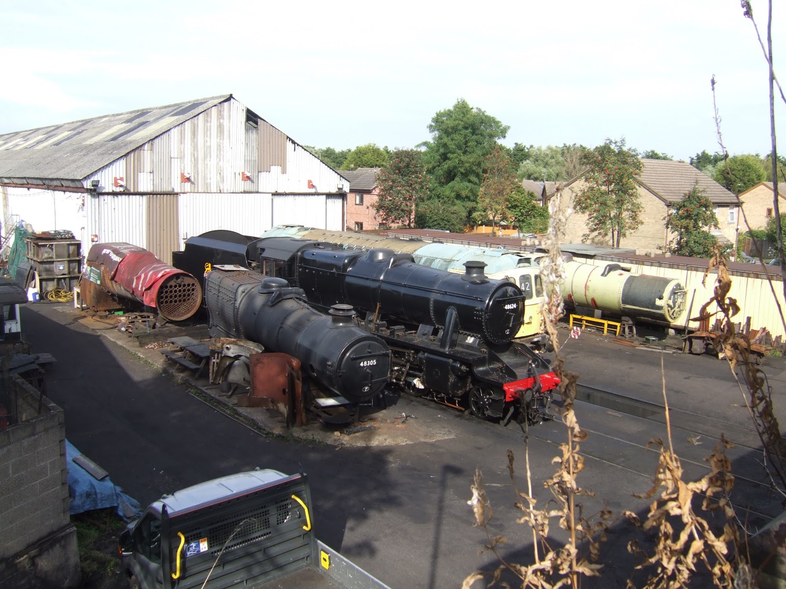
| 48624 outside Loughborough Shed. |
 |
| The GCR crossing on the Grand Union canal. |
 |
| The Railway Terrace bridge abutment. |
 |
Bridging the Gap starts here, the new bridge in situ on the Midland Main line,
the GCR heading into Nottinghamshire will become a reality! |
5,000 Miles Cumulative Total: 3,005.4 miles
2017 Total: 440.4 miles
Up Country Total: 2729.8 miles
Solo Total: 2749.1 miles
Next Up: From Harrogate back to Airedale, symbolically with The End of Summer.


No comments:
Post a Comment