10.4 miles, from Burley Park, via Hyde Park, Woodhouse, Buslingthorpe, Sheepscar, Harehills, East End Park, Cross Green, Hunslet, Beeston, Holbeck, New Wortley & Armley.
So Season 6 gets underway, whilst I'm not in work for the week and under skies that suggest the weather forecasts are kinda approximate at the moment, and it seems odd that it has taken me so many years to conceive and plot a circular walk around the City of Leeds, suggestive that only after blazing so many trails across the urban landscape do I now feel confident enough to visit so many of its Victorian - Edwardian suburbs in one go. Thus we start out from Burley Park station, on the Harrogate line, my station of choice for most of the 11 years from 1996 to 2007, to make a circuit of the city, hopeful for a good tempo to relax the legs and to keep ahead of the drizzle and penetrating cold, setting off after 10am behind the Co-op an striking up Cardigan Road past Our Lady of Lourdes church and the many large houses that were far too good and too big for student land. Strike along Victoria Road, marking the boundary between the upscale 19th century suburbia towards Headingley and the lower scale terraces of Hyde Park, and in this corner you do wonder if the exodus of students to apartment land will free up some of this district for proper living once again, because this is a fate it surely didn't deserve. It seems that the Leeds Girls School has gone from its old sire, getting some midscale urban redevelopment in its place, with only its oldest building remaining and in dire need of a makeover, and then its up to Hyde Park Corner and its pair of churches and awful pub, to make a way over the A660 and into the sketchier corner of student land in Woodhouse, always looking like the slightly forgotten corner of the University Quarter, where enough actual residents have remained to keep the prominent school active among its terraces. The aspect changes as we slip down Melville Road past later residential developments and into the industrial mix in the Meanwood Valley, where the enduring woods will not be enjoyed as we cross Meanwood Road by The Primrose and head over Meanwood Beck and up Buslingthorpe Lane, which along with its mill are the only notable features of this quasi district, where a good view towards the city would come on a clearer day, and it still seems to have actual industry up here too, as well as more traffic than the narrow and twisty lane really needs.
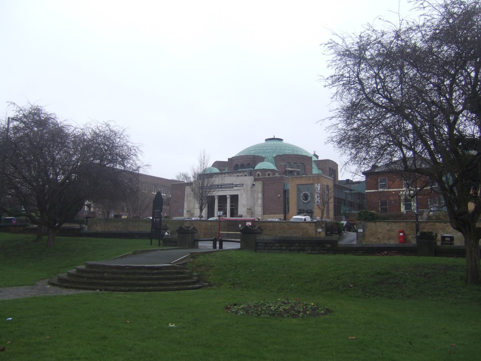
The A61 Scott Hall Road shifts us definitively into the Eastern half of Leeds, the way to Savile Mount taking us above the tangle of roads at the Sheepscar interchange and below the parklands and terraced lanes of Chapeltown, presenting us with a fine view of the Northern School of Contemporary Dance, the former Synagogue, as we roll up on Chapeltown Road. The it's on towards Harehills along the rise and fall of Leopold Street, which has developed very strangely among all the Victoriana, home to multiple schools and surely much wider than it needs to be, and then we meet the bottom of Spencer Place, a wide and leafy lane that shows up that this was planned as a much more aspirational district than it is these days. Cross over the A58 Roundhay Road, and Bayswater Road takes us on over the previous iterations of the Wetherby Road and uphill among the many terraces that surround St James's Hospital, and its all looking a bit calmer up here today as we pass along Harehills Road to Stanley Road, alongside the Cemetery, and on to Compton Road. There's many terrace ends to observe along Hudson Road, as well as an extensive factory complex on the other side, which reveals itself as the Burton's manufactory, still operational it seems and one bit of Leeds history that had completely slipped my notice in 23+ years of residence, well hidden from the casual eye despite its vast acreage. Less interest to see as we meet the later semis on Lupton Avenue, which brings us down towards the York Road, where the prominent tower block stands by the flyover and island at the junction with Torre Road, one of those interchanges that suggest much more significance than actually exists in reality, and there we pass below the A64 and move on into East End Park. Along Ivy Street, we can ponder the house styles that suggest and interruption of development by the First World War, as terraces and semis sit on matching plots, and then we meet the park itself, wandering its western edge and surely having its whole expanse to myself today, hardly a place to relax in the chill and drizzle but the best available place on the circuit to pause for an early lunch. Walking on takes us to the railway bridges of Park Parade and Pontefract Lane, and then we meet Cross Green, almost a forgotten corner of the city, the terraces facing open fields looking to the east towards the A63 and the large industrial district of Knowsthorpe, and it looks to be redeveloping a bit around here, which it probably deserves, and it soon passes as we slip down the old road down to the Aire Valley Road, below St Hilda's church and over the Hunslet Goods line once again.
Join the side of the southbound A61, and look downstream on the Aire on the South Accommodation Road bridge to visually confirm my finding that the Knostrop Cut of the A&C Navigation has been dug out in recent years, which makes it even more frustrating that the photographic record I made in 2012 of this now absent path is the only batch of pictures that I have accidentally deleted in all my walking years. Move on, below the sweeping curves of the John Smeaton Viaduct, and past that wonderfully derelict tower block to meet the Hunslet Road crossing, which can't seem to decide if its the A61 or A639, and make a shortcut along Grape Street for the industrial company of the Schneider Electrical factory, before meeting Jack Lane and sight of the works of Hunslet's locomotive building heritage. Move alongside the A61, for the last time, as it makes its passage over the old NMR metals and the cry of the M621 to slip definitively into South Leeds, dropping us onto paths in the parklands north of Beeston which sit around the Crescent Towers blocks, a surprising green space that must have been Beeston (or Hunslet?) Moor once, from where Moor Road takes us to the A653 Dewsbury Road, by the War Memorial, the former Police Station and The Junction pub, also former. Hunslet Hall Road take us on among that unattractive sort of residential development that came after the terrace clearances, dropping us at the bottom of Beeston Road, where the Old Golden Lion is looking a lot happier than it did two years ago, and passage below the M621 can roll us out onto Holbeck Moor, where new towers have risen on the site of the former ones opposite the playing fields. The abortive redevelopment of Holbeck is something to ponder as we move on towards St Matthews church, feeling that the building of the Motorway and Ring Road did this district no favours, and it take a keen eye to spot its former Victorian highlights on Domestic Street, well hidden among the terraces, before meeting the prosaic builds of the late 20th century around the still huge and immensely impressive Holbeck (or Wortley) viaduct. Still hopeful for that L&NWR monument getting a reuse in the future, as now it forms a barrier between the residential and commercial halves of Holbeck, where the old bank and school stand out incongruously among the factory units and outlet stores, and a snaking path has to be made over the A643 as it tangles up with the A58, and this probably as close as we'll be getting to the city centre today, as its high points rise above the railway bridges beyond the western throat of Leeds station.
We're not short of railway bridges on our path, mind you, as Copley Hill provides three in short order, carrying the contemporary lines to Huddersfield, Wakefield and Bradford in short order, as well as a stub of the former lines into the GNR's shed complex at Wortley Junction, a road worth visiting for this sole purpose, and the day takes this opportunity to smile on us, providing sunshine for the remainder of the trail. Arrive in New Wortley, the corner of the district that bears very little relationship to its Victorian self these days, though the few outliers can still be seen among the tower blocks and low rises these days, notably the pair of pubs at the end of Wellington Road, and attention soon focuses to the west as we rise along Tong Road, and make steps towards Armley, puzzled that it has taken me so long to get out into this south west quarter of the city. Victorian feeling revive as the road heads uphill, with the target of the district nicely obvious as we go, and the best views to be had of St Bartholemew's church are to be had from here, as its east end is the dynamic one, and it's much harder to capture once up close to it on Wesley Road, I've wittered about many churches here, but this one is certainly my favourite in the city, the perfect mix of the religious and industrial certainties of the 19th century. It's not all that Armley has to offer, as the Branch Library on Town Street is well regarded to, and I figure a lot more time could be spent investigating the Victoriana of this township in future trails, but for now, we'll head on, down to the A647 crossing by Mike's Carpets and down Ledgard Way and Canal Road to get more industrial sights, before rolling up by the old Midland Railway station, the passage over the Leeds & Liverpool canal, and the view to Armley Mills that cannot be gained from the towpath. Join the steep flight of steps down to the foot crossing of the river Aire, and admire how Viaduct Road and Kirkstall Viaduct seem to get themselves tangled up before getting a look at the old industrial relics, including Cardigan Mills that have endured among the light industry behind the complex that I still call the Warner Village. Along and over the A65 Kirkstall road before heading past the Cardigan Arms, the 'best' pub in these parts, to rise to Burley Road between the pair of St Matthias's primary schools, and on to my local old country, pacing Cardigan Lane past the former Methodist church and the still contemporary Burley Park, as well as the apartment blocks that have dropped in between the terraces, and soon it's past Beechwood Garage to close the loop and conclude my city tour, happy to have got it done in under 4 hours, wrapping the day before 2pm.
5,000 Miles Cumulative Total: 2575.4 miles
2017 Total: 10.4 miles
Up Country Total: 2348.6 miles
Solo Total: 2320.1 miles
 |
| Cardigan Road, Too Good for Student Land! |
 |
| Leeds Girls School, Hyde Park, in need of Renovation and Love. |
 |
| Woodhouse and its Prominent School. |
 |
| Buslingthorpe Lane and Mill. |
 |
The Northern School of Contemporary Dance,
the former Synagogue, Chapeltown Road. |
 |
| St James's Hospital, the prosaic western face. |
 |
| Burton's Manufactory, Hudson Road. |
 |
| East End Park, the eastern old city limits. |
 |
| St Hilda's, Cross Green. |
 |
| John Smeaton Viaduct, Hunslet. |
 |
| Crescent Towers, and Hunslet Moor, former, Beeston. |
 |
| Holbeck Moor. |
 |
| Adams Court, former Board School, Holbeck. |
 |
| The GNR Bradford line, and Wortley Junction shed stub, Copley Hill. |
 |
| St Bartholemew's Armley, the best church in the City. |
 |
| Armley Branch Library, another beauty. |
 |
| The River Aire, Kirkstall Viaduct and Viaduct Road. |
 |
| Burley Park, former Methodist Church and Park House. |
Next Up: Another City Circular, for route familiarity purposes.


No comments:
Post a Comment