14.4 miles, via Goose Hill, Crofton, Anglers Country Park, Cold Hiendley, Royston Junction, Athersley & the Dearne Valley.
Three years on from making my initial discoveries of the lost railways of West Yorkshire, by brain has finally started to make sense of the confused tangle of lines that developed across the Wakefield and South Yorkshire boundary, and with the 2015 season in its final third, it's time to start putting them down before the days start getting short again. Not that I'm managing to get going at speed, hopping off the train at Normanton station at 10am, hoping that the early mornings rains have had a chance to pass, and making the long way off the station by the hugely long footbridge, away from the ridiculously large single platform that had been intended as the major junction of George Hudson's railway empire in the 1840s. There's not a lot of vintage buildings to be found in the immediate vicinity, but I note that the new apartments on Railway Terrace at least attempt to ape the style of the original station buildings, and I soon meet my track out of town, along Wakefield Road, with mostly council flats for company, though the Roman Catholic church of St John the Baptist and the primitive Methodist Chapel both have a style to attract attention. Goosehill Road has a ginnel at its end to lead me into the countryside, sending me on a field walk to the private road leading to the Welbeck reclamation and recycling site which is gradually filling up the opencast pits which once mined coal along the banks of the Calder, and I'm coming this way to get a look at the site of Goose Hill Junction, and I'm sure that they won't mind me trespassing on the old industrial tracks to get there. I've talked about the old North Midland Mainline before, (1840-1985 for those keeping track) and tracing the section from Goose Hill to Oakenshaw is a trek which cannot be done a track level as it is so thoroughly overgrown, and so a path needs to follow paths that shadow it, passing over the bridges at Goose Hill, and shadowing it on the footpath from Cross Hills farm to Warmfield Road, where a peer from the high bridge will reveal that a lagoon has developed at track level, large enough to go boating on. Shadow again down to the A655, where trees obscure any view down into the cutting, and the main road's footway is paced down to the cluster of buildings at the edge of Heath Common before field walking to an old footbridge over the formation, where the only decent look down to the trackbed can be obtained. Odd that it could be so overgrown after having been closed only 30 years, and that Wakefield MDC hasn't been able to gain access to it, I'd imagine that this is one line that might be on the future slate for revival as an international heavy freight line.
Field walk a rather confused track to the access lane to Burcroft Farm, and pass the throat of the Bombardier Rail yard at Bracken Hill, and actually need the crossing keeper to open the gates for me to get across the Wakey - Ponte line, moving down to meet Doncaster Road and to set course away from the NMR line, towards Crofton down Lodge Lane, passing between to estate houses which named it. I don't get anywhere near the middle of Crofton though, just like on my previous visit, instead passing among the houses on Brand Hill Drive and out again on Shay Lane, moving to shadow the village and for a different railway walk via Crofton Sidings, the sports fields and public park that have grown on the site of the marshalling yard, where cricket, rugby, football and cycling all make a claim on the ground once occupied by the L&Y's Dearne Valley Junction line. A short walk down Hare Park Lane, itself a long walk away from joining the old rail yard, are more railway relics for the avid hunter, the cottages to service Hare Park Junction, and the remains of Crofton station on the Wakey - Donny Line, another one that you'd imagine could be worth a revival. Move into the fields and away from railway walking for a while for the trek through the lands of Hare park farm, which has endured despite being surrounded by opencast coal mining for much of the 20th century, and it's a grassy walk in the direction of Anglers Country Park, to attack another section of the perimeter path, after I've stuffed lunch into my face. Unfortunately only a third of the Lakeside Path on the west side hangs close to the water, the remainder having been moved away to accommodate a wildlife reserve, so the views aren't so good but I do get explanation of all the witch related carvings, having young nieces means I am at least aware of 'Room on the Broom'. Meet the Wakefield Way route and pass out of the park, to follow Haw Park Lane as far as the track that leads into the grounds of Wintersett Reservoir, dropping me below the dam, and thus getting better views of the lower Cold Hiendley Reservoir before cutting a rough track up to get brief view of its much larger neighbour, and that's enough to gain the day a reservoir walking tag. A path through a stubbly field leads me vaguely over to the hamlet of Cold Hiendley, and then there's more of the same beyond, the footpath being invisible due to recent harvesting on the long stretch over to the Common Lane, even trying to use the pylons as navigational aids proves impossible.
Meet Navvy Lane, which leads to the High Bridge over the Barnsley Canal, deliberately avoided on my last visit, and the huge Notton Bridge over the Midland Railway's Royston Junction, unfortunately missed on the same occasion, but I have different line in my sights, the Barnsley Coal Railway of 1882 - 1961, originally operated by the M&SLR between Nostell and Stairfoot, and one of those lines that makes you wonder which way the coal was supposed to be travelling? It does provide me with a red route for most of the way to Barnsley, initially providing an overbridge over a vegetation choked cutting which the path shadows, eventually shifting to trackbed level before descending to Station Road outside Royston, with a large bridge abutment being the only remnant of the station which passed as long ago as 1930. The Royston & Carlton Circular Walk has claimed the trackbed beyond, providing a long and shady walk that carries me parallel to the town, with hints of back gardens and equestrian fields showing up through the foliage as I tramp the border of West Yorkshire, moving into the South Riding (sic) at Lee Lane. More straightforward going along the embankment southwards, running up to the junction into the Wharncliffe Woodmoor Colliery site, where a small fragment of the points levering remains in situ in the ground and the path enters a rather damp, but attractively sun dappled, cutting that slips behind the council houses of the Athersley estate. Pass under the A61 overbridge, and move clearly into the Dearne Valley, and as sights to Barnsley and the South Yorkshire hills emerge, I'm struck just how green this river's dale is when so close to a town built on the coal industry, I'm guessing that late 20th century landscaping is happily responsible. The path remains obvious through this rough parkland, eventually gaining a railway aspect again in its late stages, passing over a couple of underbridges before abruptly ending past the Smithies Lane Bridge, which requires a loop beneath it before following the lane down to the crossing of the Dearne. The greenery continues at the Valley bottom, passing alongside The Fleets Dam fishing lake, a peaceful idyll in the heart of the down, passing away from the River at the Old Mill Lane bridge and hitting the only significant ascent of the day on the closing stretch, among the terraces on Eldon Street North, and cutting the shortest route to Exchange station along Schwabisch Gmund Way, done at 3.30pm just in time to catch the Party Express back to West Yorkshire.
5,000 Miles Cumulative Total: 1866.4 miles 2015 Cumulative Total: 464.2 miles
Up Country Total: 1706.7 miles
Solo Total: 1654.4 miles
 |
| Normanton Station, possibly the longest platforms you'll ever meet on a station that has no inter-city services! |
 |
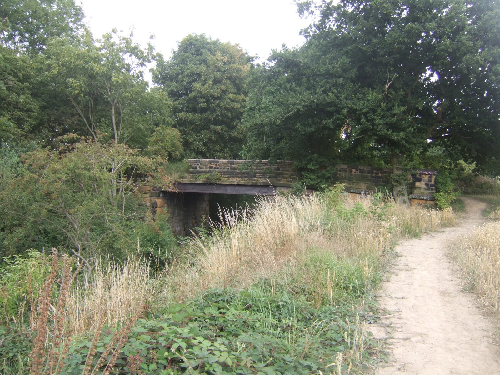
| Goose Hill Junction NMR Overbridge. |
 |
Warmfield Road lagoon, not a river or a canal, this was a railway,
really, one which I once rode along, 30-some years ago. |
 |
| NMR footbridge, between Heath Common and Bracken Hill. |
 |
Bombardier Rail Yard, Bracken Hill. I think the crossing keeper was surprised to see me,
and he didn't find my arrival to be a reason to interrupt his phone conversation, either. |
 |
| Crofton Sidings Playing Fields. |
 |
| Anglers Country Park, again. |
 |
| Cold Hiendley Reservoir. |
 |
| Navvy Lane High Bridge, hello again to the Barnsley Canal. |
 |
| The Barnsley Coal Railway, occupation bridge near Royston Junction, |
 |
| BCR outside Royston, shade most appreciated when I've forgotten to apply sunblock. |
 |
| Wharncliffe Woodmoor Colliery Junction. |
 |
| The A61 bridge, between Staincross and Athersley. |
 |
| Smithies Lane Bridge, Barnsley. |
 |
| The Fleets Dam fishing lake, and Barnsley's capacity for greenness never ceases to amaze me. |
Next Up: Striding out for Bank Holiday weekend (weather and enthusiasm permitting).


No comments:
Post a Comment